mettatec X5 User manual

Category
GPS receiver modules
Type
User manual

mettatec X5: Your Advanced GNSS Positioning Solution

mettatec X5 is a high-precision GNSS receiver that connects to your Android smartphone or tablet. It offers centimeter-level accuracy with fast convergence times and robust performance. Use it for entry-level and professional surveying tasks with RTK+PPK+NTRIP corrections.

Key Features:

  • Multi-band RTK (433MHz and 915MHz), PPK, and NTRIP corrections
  • Simultaneous reception of GPS, GLONASS, GALILEO, and BEIDOU constellations
  • Built-in multi-band helical GNSS and LoRa antennas
  • Data transfer via USB port and Bluetooth
  • Compatible with GIS and Photogrammetry apps that use NMEA data
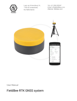
GNSS X5 Mobile Pro RTK
The high precision external GNSS antenna
receiver that works with your Android
smartphone or tablet. The perfect solution
for entry-level and field experienced
professional users with RTK+PPK+NTRIP
corrections.
Description
The X5 Mobile Pro is a high-precision GNSS receiver that operates connected to an Android
smartphone or tablet and features an RTK correction system that receives data via LoRa.
Main Advantages:
Multi-band RTK (433MHz and 915MHz frequencies available), PPK and NTRIP
corrections with fast convergence times and robust performance, offers centimeter-
level accuracy with a Fix solution in seconds
Uses the same GNSS L1/L2/e5 technology found in professional receivers with state-
of-the-art components
Simultaneous reception of all constellations: GPS, GLONASS, GALILEO and BEIDOU
Includes its own multi-band helical GNSS and LoRa antennas
Data transfer connection via USB port and Bluetooth
Compatible with GIS and Photogrammetry Applications that operate with NMEA data
It has a red point Laser for easy location of the points to be georeferenced on the field
Rugged plastic enclosure
X5 Mobile Pro Components:
GNSS X5 Mobile Pro unit
HeliX5 multi-band GNSS antenna
LoRa 433 MHz or 915 MHz antenna (Frequency selected by client)
Rover pole Adapter with 5/8” thread
USB Type-C cable for power supply
Image: X5 Mobile components
Compatible Android apps:
SW Maps
FieldGenius
Survey Master
Mapit GIS / Mapit NTRIP Client
YCServer NTRIP Client
RTK camera (Photogrammetry)
and other Apps and Software that use or accept NMEA data via Bluetooth or Serial
USB
1. SPECIFICATIONS
Mechanical
Dimensions: 85 × 40 × 13 mm (without antenna)
Weight: 80g
Operation temperature: -40 to 85 °C
Enclosed Design
Electrical
Input voltage: 4.75 5.5 V, ≥ 5.0 V ensures output power
Antenna DC bias: 3.3 V
Peak current consumption: 5V @ 250 mA
Average current consumption: 5V @ 120 mA
Current limit on USB cable: 500 mA
Connectivity
Bluetooth V4.2 BR/EDR
USB Serial
GNSS
Concurrent reception of GPS, GLONASS, Galileo and BeiDou
Receives both L1C/A and L2C bands
Signal tracked GPS/QZSS L1 C/A, L2 GLONASS L1OF, L2
BeiDou B1l, B2l Galileo E1-B/C, E5b
Number of channels 184
Navigation update rate: 1 Hz GNSS
Position accuracy: NTRIP 0.01 m + 1 ppm CEP
Convergence time: NTRIP < 10 sec
Time to First Fix: 25s (cold), 2s (hot)
Max Altitude: 50 km (31 miles)
Max Velocity: 500 m/s (1118 mph)
Radio configuration
Global license-free ISM 433MHz or 915MHz band
Air rate: 19.2 kbps (default)
Transmission power: 30 dBm (default)
Antenna gain: 5 dBi
Max distance: 10 km, in clear open area and line of sight
2. PORTS DESCRIPTION
USB-C
Powering the device
Antenna Connector
SMA connector for 433MHz/915MHz LoRa antenna
MCX connector for GNSS antenna
3. LEDS DESCRIPTION
RF LED
Blinking: Transmitting or receiving data with LoRa (Rx/Tx)
BT LED
Blinking: Waiting for Bluetooth connection
Solid: Bluetooth connected
4. OPERATION MODES
The device includes a switch for the different operation modes:
Configuration
To change LoRa parameters with the executable application
Transmission
To receive the corrections from the Base Station
  • Page 1 1
  • Page 2 2
  • Page 3 3
  • Page 4 4

mettatec X5 User manual

Category
GPS receiver modules
Type
User manual

mettatec X5: Your Advanced GNSS Positioning Solution

mettatec X5 is a high-precision GNSS receiver that connects to your Android smartphone or tablet. It offers centimeter-level accuracy with fast convergence times and robust performance. Use it for entry-level and professional surveying tasks with RTK+PPK+NTRIP corrections.

Key Features:

  • Multi-band RTK (433MHz and 915MHz), PPK, and NTRIP corrections
  • Simultaneous reception of GPS, GLONASS, GALILEO, and BEIDOU constellations
  • Built-in multi-band helical GNSS and LoRa antennas
  • Data transfer via USB port and Bluetooth
  • Compatible with GIS and Photogrammetry apps that use NMEA data

Ask a question and I''ll find the answer in the document

Finding information in a document is now easier with AI