
1
TABLE OF CONTENTS
Table of Contents
IMPORTANT NOTICES AND WARNINGS .......................................................... 5
This Documentation.......................................................................................................... 5
Global Positioning System ................................................................................................. 5
Precautions ...................................................................................................................... 5
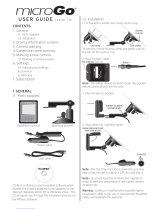
WHAT’S IN THE BOX ....................................................................................... 6
1. GETTING TO KNOW YOUR NAVIG8R GPS .................................................... 6
1.1 Warning ...................................................................................................................... 7
1.2 Before Using Your Navig8r GPS Unit ............................................................................ 7
1.3 Mounting the GPS Unit in Your Vehicle ........................................................................ 8
1.4 Connecting the Car Charger ......................................................................................... 8
NAVIGATION .................................................................................................. 9
Before Using the Navig8r Please Read the Following ....................................................... 10
Key Features ................................................................................................................... 10
2. Getting Started With Your Navig8r GPS System ........................................................... 11
2.1 Start Up Screen: The Navigation Menu ...................................................................... 13
2.2 Buttons and Other Controls on the Screen ................................................................. 14
2.2.1 Using Keyboards ......................................................................................................... 15
2.2.2 Beyond Single Screen Taps ......................................................................................... 16
2.3 Map Screen ............................................................................................................... 17
2.3.1 Navigating On The Map .............................................................................................. 17
2.3.2 Position Markers ......................................................................................................... 19
2.3.3 Objects on the Map .................................................................................................... 20
2.3.3.2 Turn Preview and Next Street ................................................................................. 20
2.3.4 Manipulating the Map ................................................................................................ 22
2.3.5 Quick Menu ................................................................................................................ 23
2.3.6 Checking the Details of the Current Position (Where Am I?) ..................................... 27

2
TABLE OF CONTENTS
3. NAVIGATION ............................................................................................ 29
3.1 Selecting the Destination of A Route ......................................................................... 29
3.1.1 Entering an Address or a Part of the Address ............................................................ 30
3.1.2 Selecting the Destination from the Places of Interest ............................................... 37
3.1.3 Selecting a Map Location as the Destination ............................................................. 47
3.1.4 Selecting the Destination from your Favourites ........................................................ 48
3.1.5 Selecting One of the Most Likely Destinations (Smart History) ................................. 49
3.1.6 Selecting a Recent Destination From the History....................................................... 50
3.1.7 Building a Route from the List of Destinations (Create Route) .................................. 51
3.2 Viewing the Entire Route on the Map ........................................................................ 52
3.3 Checking route parameters and accessing route related functions ............................. 52
3.4 Modifying the Route ................................................................................................. 53
3.4.1 Selecting a New Destination When Already Having a Route: New Route, Waypoint or
Final Destination .................................................................................................................. 53
3.4.2 Setting a New Starting Position for the Route ........................................................... 54
3.4.3 Editing the List of Destinations (Edit Route) .............................................................. 56
3.4.4 Pausing the Active Route ............................................................................................ 56
3.4.5 Cancelling the Active Route ........................................................................................ 57
3.4.6 Changing the Route Planning Method (Route Alternatives) ...................................... 57
3.4.7 Changing the Vehicle Used in Route Planning ........................................................... 59
3.4.8 Changing the Road Types Used in Route Planning ..................................................... 60
3.5 Saving a Location as a Favourite Destination ............................................................. 61
3.6 Watching the Simulation of the Route ....................................................................... 62
4. REFERENCE GUIDE .................................................................................... 63
4.1 Concepts ................................................................................................................... 63
4.1.1 Smart Zoom ................................................................................................................ 63
4.1.2 Daytime and Night Colour Themes ............................................................................ 63
4.1.3 Colour Theme in Tunnels ............................................................................................ 63
4.1.4 Route Calculation and Recalculation .......................................................................... 64
4.1.5 Road Safety Cameras and Other Proximity Alert Points ............................................ 66
4.1.6 Speed Limit Warning .................................................................................................. 67
4.1.7 Battery and GPS Position Quality Indicators .............................................................. 67
4.2 'More' Menu ............................................................................................................. 69
4.3 Settings Menu ........................................................................................................... 70
4.3.1 Sound and Warnings ................................................................................................... 72
4.3.2 Customise Quick Menu ............................................................................................... 74

3
TABLE OF CONTENTS
4.3.3 Traffic Settings ............................................................................................................ 76
4.3.4 Route Settings ............................................................................................................. 76
4.3.4.2 Route Planning Method Types ............................................................................. 79
4.3.5 Vehicle Profile ........................................................................................................ 79
4.3.6 Map Settings ............................................................................................................... 81
4.3.7 Visual Guidance Settings ............................................................................................ 82
4.3.8 Display Settings ........................................................................................................... 83
4.3.9 Regional Settings ........................................................................................................ 83
4.3.10 Trip Monitor Settings ................................................................................................ 84
4.3.11 Log Collection ........................................................................................................... 84
4.3.12 Start Configuration Wizard ....................................................................................... 84
4.3.13 Reset to Defaults ...................................................................................................... 84
5 UPDATING ................................................................................................. 85
6 GLOSSARY ................................................................................................. 86
2D/3D GPS reception ...................................................................................................... 86
Active Route ................................................................................................................... 86
City Centre ...................................................................................................................... 86
Colour Theme ................................................................................................................. 86
GPS Accuracy .................................................................................................................. 86
Map ................................................................................................................................ 87
North-Up Map Orientation ............................................................................................. 87
Road Safety Camera ........................................................................................................ 87
Route ............................................................................................................................. 87
Track-Up Map Orientation .............................................................................................. 87
Vehimarker..................................................................................................................... 87
HARDWARE .................................................................................................. 88
6 MAIN SYSTEM MENU ................................................................................ 89
6.1 GPS ........................................................................................................................... 90

4
TABLE OF CONTENTS
6.2 SYSTEM ..................................................................................................................... 90
6.2.1 Language ..................................................................................................................... 91
6.2.2 Backlight ..................................................................................................................... 91
6.2.3 Power .......................................................................................................................... 91
6.2.4 Sound .......................................................................................................................... 92
6.2.5 Time ............................................................................................................................ 92
6.2.6 Sound .......................................................................................................................... 93
6.2.7 System ........................................................................................................................ 93
6.3 Tools ......................................................................................................................... 94
6.3.1 Calculator .................................................................................................................... 94
6.3.2 Picture Viewer ............................................................................................................ 94
6.4 GPS Test .................................................................................................................... 95
7 TECHNICAL SPECIFICATIONS ...................................................................... 96
T43B ............................................................................................................................... 96
T50B ............................................................................................................................... 96
8 FREQUENTLY ASKED QUESTIONS ............................................................... 97
9 END USER LICENCE AGREEMENT (EULA) .................................................. 102
10 COPYRIGHT NOTE .................................................................................. 106

5
IMPORTANT NOTICES AND WARNINGS
Important Notices and Warnings
This Documentation
Thank you for choosing our product as your navigator. Read the Quick Start Guide first and start
using your device right away. This document is the detailed description of the navigation software
and hardware. You can easily discover the software while you are using it; however, we still
recommend that you read this manual to fully understand the screens and features.
Global Positioning System
The Global Position System (GPS) is a satellite-based system that provides location and timing
information around the globe.
GPS is operated and controlled under the sole responsibility of the Government of the United States
of America, who are responsible for its availability and accuracy. Any changes in GPS availability and
accuracy or in environmental conditions, may affect the operation of your Navig8r. We cannot
accept any liability for the availability or accuracy of GPS.
Precautions
For your safety and the safety of other road users, do not operate the controls of this Navig8r while
driving. Use care when operating the Navig8r. This product is intended to be used only as an aid to
navigate. It is not intended for the precise measurement of direction, distance, or location
topography.
The Calculated routes are for reference only. It is the user’s responsibility to follow all local traffic
regulations and traffic signs when driving. Local conditions and regulations may change at short
notice and may not be included in the software/mapping data of this product.
When leaving your vehicle, do not leave the Navig8r on the dashboard of the car. It should be
removed and placed in a secure place along with the windscreen mount and power cable. Do not
leave the Navig8r in direct sunlight or in an enclosed vehicle when not in use. Overheating of the
battery may cause damage or cause the Navig8r to malfunction. Extreme overheating may cause
the battery to leak.
GPS satellite signals cannot pass through solid materials with the exception of glass. When travelling
through tunnels or inside buildings, such as parking stations, GPS positioning is not available. The
time taken for the Navig8r to re-acquire satellite signals when emerging from tunnels or buildings
may vary and will depend on atmospheric conditions and the environment.
A minimum of four GPS satellite signals is required to determine the Navig8rs current location. Signal
reception can be affected by atmospheric conditions such as; bad weather, thick clouds, solar
activity and dense overhead objects such as trees, tall buildings and large road signs. Wireless
devices can also interfere with satellite reception.
The use of devices with a GPS antenna is prohibited on most aircraft, hospitals and other locations
that contain sensitive equipment. The Navig8r should not be used in these environments.

6
WHAT’S IN THE BOX
What’s in the Box
Unpack the box and identify the contents. You should have the following items:
ITEM
DESCRIPTION ITEM DESCRIPTION
1
The Navig8r GPS unit
2
GPS device holder
3 Bracket/Windscreen Mount 4 Car Charger (12v DC)
5
USB Data Cable
1. Getting To Know Your Navig8r GPS
ITEM
DESCRIPTI
ON
ITEM
DESCRIPTION
1
Power Button
2
3.5mm Stereo Earphone Jack
3
Micro SDHC Card Slot
(Card not supplied)
4
USB Connection Socket
5
Reset button
6
Stylus
7
Speaker
Face
LCD Touch screen

7
WARNING
1.1 Warning
This Navig8r GPS should not be used in conditions of high temperature, high humidity or dusty
conditions. We recommend that the Navig8r is not left in direct sunlight for extended periods or left
fitted to the windscreen, dashboard or glove box.
Prolonged exposure to high temperatures may cause the Navig8r to malfunction and may even
cause permanent damage to the Navig8r.
There are no user serviceable parts in this device. Opening the device may cause harm and damage
the device. Any attempt to disassemble this device will void the warranty.
Images, screen shots and features shown in this manual may vary slightly from the actual product.
We reserve the right to make changes to this product without notice.
1.2 Before Using Your Navig8r GPS Unit
Please check the contents of the packaging and ensure that all equipment is located and identified.
The protective screen cover may be left on the device but may impede the viewing of the device in
normal operation.
Connect the Navig8r GPS unit to power source for a period of 24 hours in the first instance to charge
and condition the battery. It may take several charge/discharge cycles for the device to reach peak
endurance. The charging process will take longer if the device is turned on.
Subsequent charging should take less time to complete.
This GPS can only be charged from the PC USB port when the Navig8r is turned OFF.
Once the initial charge has been completed turn the GPS device on. The Navig8r should launch the
Navigation software.
To turn the device off for short periods simply remove the Navig8r from its power supply (or turn the
ignition off). If the navigation software is running the Navig8r will detect the power off and place
itself in sleep mode. When the power is turned back on again the Navig8r will start at the last screen
shown.
The GPS will continue to draw power from the battery in sleep mode and will go flat after 24 to 36
hours.
To turn the GPS off manually or if the device is not to be used for periods longer than two or three
days, simply press the power button for 3 seconds and then tap the shut down option or cancel to
return to the previous screen.
If no option is selected the Navig8r will turn off after 15 seconds.
Prior to using the GPS system for the first time, it is recommended that the touch screen be
calibrated. Please see the system setting instructions further on in this manual.

8
CONNECTING THE CAR CHARGER
1.3 Mounting the GPS Unit in Your Vehicle
Fit the windscreen mount to the holder which you have attached to the rear of the GPS unit and test
mount the GPS on the windscreen of the car. Choose a position that will not obstruct your vision
whilst driving but will also provide the GPS unit the best coverage of the sky through the windscreen.
Loosen the two knobs on the mount to allow movement of the pivot points.
The Navig8r should only be fitted on fixed windows.
Once the best location has been determined, remove the protective film from the suction cap of the
windscreen mount and, on clean glass, fit firmly against the windscreen. Push the tab located on the
top of the suction cup towards the windscreen until it locks in place. For best results it is
recommended that the suction cup be moistened before fitting.
In a normal driving position adjust the GPS to a position that will be in view whilst driving and does
not obstruct your view of the road. Once the correct position has been found tighten the two knobs
on the mount to prevent the GPS moving from vibration. Do not over tighten these knobs.
Changes in temperatures and condensation may cause the suction cup to become loose and should
be checked on a regular basis. To avoid damage or theft, the GPS should not be left on the
windscreen mount overnight.
To remove the mount from the windscreen, take hold of the mount in one hand and use the other to
pull the tab away from the mount. Locate the plastic tab on the side of the suction cup and gently
pull away from the windscreen to break the seal.
N.B: Tinted windows may impede the Navig8rs ability to detect the GPS satellites correctly.
1.4 Connecting the Car Charger
Caution: To protect the GPS against the possibility of damage caused by power surges when the
vehicle is started, the charger should not be connected to the GPS device when the vehicle is
started.
The car charger supplies power to the device when it is being used in the vehicle.
Connect the USB plug to the USB socket of the GPS and then fit the other end in to the
cigarette/power outlet of your vehicle once the vehicle has been started.
The charge light indicator on the GPS should glow when connected to power.
The GPS can now be started by pressing the power button on top of the device for about 3 seconds.
When starting the GPS in the vehicle it may take a short period of time for the system to acquire a
valid GPS signal. Please make sure that the GPS unit has a clear view of the sky and is not impeded
by trees, awnings, car ports or similar obstructions.

9
NAVIGATION
NAVIGATION

10
TABLE OF CONTENTS
Before Using the Navig8r Please Read the Following
Personal Navigation devices are designed to be an aid to navigation only. They are to be used in
conjunction with all local road rules, laws and regulations. It is the responsibility of the driver to
ensure that the vehicle is driven in a safe manner in compliance with these laws.
In most states it is illegal to operate a GPS system while driving a vehicle. When entering information
into the GPS, please pull over safely to the side of the road before using this device. It is better to set
the destination for the GPS before you start on your trip rather than trying to enter it on the move.
When positioning the GPS system on the windscreen of your vehicle, make sure that it is placed in a
position that provides a clear view of the road ahead and ensure the driver does not have to look
away from the road to check the screen.
Please read the hardware section to ensure that all accessories can be identified and you can
assemble the navig8r GPS. Also please read the section on “Mounting the GPS unit in your vehicle”
in the hardware section to ensure that the Navig8r is mounted safely and securely.
The first time the GPS unit is used, or it has not been used for some time, it may take some several
minutes for it to detect the GPS satellites. Restarting the system in the same location should acquire
the signals quickly.
Please read this section carefully.
Key Features
Spoken Street names (TTS)
Speed limits and over speed warnings.*
Driver Safety warnings including School Zone, Black Spots, Fixed location
infringement Cameras, railway crossing and others.**
Intuitive menus.
Huge array of POI (Points Of Interest) data
Simple to use.
*Data included in this software is for guidance only and is only provided as an indicator and does not
cover work works. Not all roads or areas are covered. It is the responsibility to drive with in the
posted speed limit.
**Warnings are provided as an aid to driving only. The data provided in the device may not cover all
points. Please drive according to the conditions and take note of any posted warning signs.

11
GETTING STARTED WITH YOUR NAVIG8R GPS SYSTEM
2. Getting Started With Your Navig8r GPS System
Mount and connect the Navig8r as described in this manual. Press the power button on the top of
the Navig8r. The Navigation software will run automatically.
The software is optimised for in-car or pedestrian use. There is no need to use a stylus. You can use
it easily by tapping the screen buttons and the map with your fingertips. However a stylus is
supplied.
When using the navigation software for the first time, an initial setup process starts automatically.
Do as follows:
1. Select the written language of the
application interface.
Later you can change it in Regional
settings.
Tap the , or the button to
scroll through the selection. Tap
the button to
confirm the selection.
2. Read the End User Licence
Agreement.
Tap to continue.
If you do not agree with the terms
and conditions please tap the
button to exit the
software and go to the main
hardware menu.
3. To continue with the configuration
wizard please tap the
button.

12
GETTING STARTED WITH YOUR NAVIG8R GPS SYSTEM
4. Select the language that you would
like to hear the voice commands
in. button.
Tap the , or the button to
scroll through the selection. Tap
the button to
confirm the selection.
For Spoken Street name, please
select a voice marked (TTS).
5. If needed, modify the time format
and unit settings.
Later you can change them in
Regional settings.
Tap the button to confirm
and continue.
6. Set the preferred default Route
Settings to be used by the GPS.
Route Settings are explained in detail on
page XX
Tap the at any stage, if
shown to go back to the previous screen.
7. Tap the to
complete the wizard an continue
to the Navigation Screen
Tap the at any stage, if
shown to go back to the previous screen.

13
GETTING STARTED WITH YOUR NAVIG8R GPS SYSTEM
Tap the YES or NO button to allow or
deny the collection of GPS logs.
Tap the at any stage, if
shown to go back to the previous screen.
2.1 Start Up Screen: The Navigation Menu
The software starts with its main menu, the Navigation Menu. From here you can reach all parts of
the Software
Tap to select your destination by entering an address or selecting a place of
interest, a location on the map and or select from one of your Favourites.
Shows the route parameters and the route in its full length on the map. You
can also perform route related actions such as editing, alter route settings,
or avoid parts of the route.
Customise the way the navigation software works and looks, watch the
Tutorial
, simulate demo routes, or run some additional applications.
Start navigating on the map. The button itself is a miniature live map that
shows current position, recommended route and the surrounding map area.
Tap to show full map screen.
Exits the navigation software and go to the Hardware menu.

14
GETTING STARTED WITH YOUR NAVIG8R GPS SYSTEM
2.2 Buttons and Other Controls on the Screen
When you are using the software, you usually tap buttons on the touch screen.
You only need to confirm selections or changes if the application needs to restart, it needs to
perform a major reconfiguration, or you are about to lose some of your data or settings. Otherwise,
the software saves your selections and applies the new settings without confirmation as soon as you
use the controls.
TYPE EXAMPLE DESCRIPTION HOW IT WORKS
Button
Tap it to initiate a function,
to open a new screen, or to
set a parameter.
Tap it once
Button
with
value
Some buttons display the
current value of a field or
setting. Tap the button to
change the value. After the
change, the new value is
shown on the button.
Tap to change value.
Icon
Shows status or
information.
Some icons function as buttons.
Tap to change
List
Displayed when Several
options are available.
List can be moved by sliding
finger tip up and down the
screen until the list ends or using
the & to move between
pages. Tap on the required
selection and then the
conformation button if required.
Radio
Button
When there are only a few
choices, radio buttons may
be used instead of lists.
Only one value can be
selected
Tap one of the buttons to select
the new value.
Switch
When there are only two
choices, a checkmark
shows whether the feature
is enabled.
Tap it to turn the switch on or
off.
Slider
When a feature can be set
to different values in a
range, the software shows
an indicator on a gauge
that displays and sets the
value.
Drag the handle to move the
slider
to its new position.
Tap the
slider
where you want
the handle to appear; the thumb
jumps there.
Virtual
Keyboard
Alphabetic and
alphanumeric keyboards to
enter text and numbers.
Each key is a touch screen
button.
Only available letters or numbers
will be available to touch

15
GETTING STARTED WITH YOUR NAVIG8R GPS SYSTEM
2.2.1 Using Keyboards
You only need to enter letters or numbers when you cannot avoid it. You can type with your
fingertips on the full-screen keyboards and you can switch between various keyboard layouts, for
example English, Greek or numerical.
TASK
INSTRUCTION
Switching to another keyboard layout, for
example from an English keyboard to a
Greek keyboard Tap the button and select the
new keyboard layout from the list.
Correcting your entry on the keyboard
Tap to remove the unneeded character(s).
Tap and hold the button to delete several characters
or the entire input string.
Entering a space, for example between a
first name and a family name or in multi-
word street names Tap the button at the bottom centre of the
screen.
Entering numbers and symbols
Tap to switch to a keyboard offering numeric
and symbol characters.
Finalising the keyboard entry (accepting the
suggested search result) Tap
Finalising the keyboard entry (opening the
list of search results) Tap
Finalising the keyboard entry (saving your
input) Tap
Cancelling the keyboard entry (returning to
the previous screen) Tap

16
GETTING STARTED WITH YOUR NAVIG8R GPS SYSTEM
2.2.2 Beyond Single Screen Taps
You usually need to tap the screen only once. However, some useful features can be accessed with
combined touch screen tapping. Those are the following:
ACTION
DETAILS
Tapping and holding the
screen Tap and keep pressing the following buttons to reach extra functions:
• Tap and hold on list and menu screens: the
Map screen appears.
• Tap and hold any of the , , , , , and
buttons on the Map screen: you can rotate, tilt or scale the
map continuously.
• Tap and hold on keyboard screens: you can delete several
characters quickly.
• Tap and hold or in long lists: you can scroll pages
continuously.
Gestures (drag & drop) You need to drag and drop the screen only in cases like:
• Moving the handle on a slider.
• Scrolling the list: grab the list anywhere and slide your finger up or
down. Depending on the speed of the sliding, the list will scroll fast
or slow, only a bit or till the end.
• Moving the map in map browsing mode: grab the map, and move it
in the desired direction.

17
MAP SCREEN
2.3 Map Screen
2.3.1 Navigating On The Map
The
Map screen
is the most frequently
used screen of the software.
A small live map is displayed on the start-
up screen, the Navigation menu, as a part
of the button. Tap
anywhere in this area to show the Main
Map screen.
This map shows the
cu
rrent position
(the
Vehimarker, a red arrow by default), the
recommended route (an orange line), and
the surrounding map area.
When there is no
GPS
position, the
Vehimarker is transparent. It shows your
last known position.
You see coloured dots circling around a satellite symbol in the top left corner. The more green dots
you see, the closer you are to get the valid GPS position.
When
GPS position
is available, the
Vehimarker is displayed in full colour,
now showing your current position.
There are screen buttons and data fields
on the screen to help you navigate.
During navigation, the screen shows
route information.
By default, only one data field is displayed in the bottom right corner. Tap this field to
see all route data fields.

18
MAP SCREEN
Default data fields when cruising without a destination (tap and hold any of the fields to change its
value):
FIELD
DESCRIPTION
Shows your current speed given by the GPS receiver.
Shows the speed limit of the current road if the map contains it.
Shows the current time corrected with time zone offset. The accurate time
comes from the
GPS
satellites, and the time zone information comes from the
map or it can be set manually in Regional settings
.
(The current time is always displayed in the top left corner of menu screens.)
Default data fields when navigating a route (tap and hold any of the fields to change its value):
FIELD
DESCRIPTION
Shows the distance you need to travel on the route before reaching your
final destination.
Shows the time needed to reach the final
destination
of the
route
based on
information available for the remaining segments of the
route
.
However, the Navig8r is not able to take in to account external factors and
this is an estimated time only.
Shows
the
estimated arrival
time at the final
destination
of the
route
based on
information available for the remaining segments of the
route
.
However, the Navig8r is not able to take in to account external factors and
this is an estimated time only.

19
MAP SCREEN
2.3.2 Position Markers
2.3.2.1 Vehimarker and Lock-On-Road
When your GPS position is available, the software marks your current position with the Vehimarker. By
default, this marker is a blue arrow, but you can change this icon in Settings.
The exact location of the Vehimarker depends on the vehicle type used for route calculation. The vehicle type
can be selected in Route settings.
If you choose pedestrian: The Vehimarker is at your exact GPS position. The direction of the icon
shows your current heading.
If you choose any of the vehicles: The Vehimarker may not show your exact GPS position and heading.
If roads are near, it is aligned to the nearest road to suppress GPS position errors, and the direction of
the icon is aligned to the direction of the road.
2.3.2.2 Selected Map Location (Cursor)
You can mark a map location in the following ways:
• Tap the map when navigating,
• Tap the map when you are asked to confirm the destination at the end of a search, or
• Tap the map in Find on Map (page 47)
When a map location is selected, the Cursor appears at the selected point on the map. The Cursor is displayed
with a radiating red dot ( ) to make it visible at all zoom levels.
The location of the Cursor can be used as the destination of the route, you can search for Places around it, or
you can save this location as one of your Favourite destinations
.

2.3.3 Objects on t
he Map
2.3.3.1 Streets a
nd Roads
The software shows the streets in a way that
Their width and colours correspond to their importance: you can easily tell a
street.
2.3.3.2 Turn P
review and Next Street
When navigating a route, the top section of the Map screen s
event (manoeuvre) and the next street or the next city/town
There is a field in the top left corner that
displays the next manoeuvre. Both the
type of the event (turn, roundabout,
exiting motorway, etc.) and its dista
from the current position are displayed.
A smaller icon shows the type of the
second next manoeuvre if it is near the
first one. Otherwise, only the next
manoeuvre is displayed.
Most of these icons are very intuitive. The following table lists
route events. The same symbols are used in both fields:
ICON
DESCRIPTION
Turn left.
Turn right.
Turn back.
Bear right.
Turn sharp left.
Keep left.
Continue straight in the
Go left on the roundabout, 3rd exit
(next manoeuvre).
he Map
nd Roads
The software shows the streets in a way that
is similar to how the paper road maps show them.
Their width and colours correspond to their importance: you can easily tell a
motorway
review and Next Street
When navigating a route, the top section of the Map screen s
hows information about the next route
event (manoeuvre) and the next street or the next city/town
.
There is a field in the top left corner that
displays the next manoeuvre. Both the
type of the event (turn, roundabout,
exiting motorway, etc.) and its dista
nce
from the current position are displayed.
A smaller icon shows the type of the
second next manoeuvre if it is near the
first one. Otherwise, only the next
Most of these icons are very intuitive. The following table lists
just
some of the frequently shown
route events. The same symbols are used in both fields:
DESCRIPTION
ICON
DESCRIPTION
Enter roundabout (second next
manoeuvre)
Enter motorway.
Exit motorway.
Board ferry.
Leave ferry.
Approaching a waypoint.
Continue straight in the
intersection.
Approaching the destination.
Go left on the roundabout, 3rd exit
20
MAP SCREEN
is similar to how the paper road maps show them.
motorway
from a small
hows information about the next route
some of the frequently shown
DESCRIPTION
Enter roundabout (second next
Approaching a waypoint.
Approaching the destination.
Page is loading ...
Page is loading ...
Page is loading ...
Page is loading ...
Page is loading ...
Page is loading ...
Page is loading ...
Page is loading ...
Page is loading ...
Page is loading ...
Page is loading ...
Page is loading ...
Page is loading ...
Page is loading ...
Page is loading ...
Page is loading ...
Page is loading ...
Page is loading ...
Page is loading ...
Page is loading ...
Page is loading ...
Page is loading ...
Page is loading ...
Page is loading ...
Page is loading ...
Page is loading ...
Page is loading ...
Page is loading ...
Page is loading ...
Page is loading ...
Page is loading ...
Page is loading ...
Page is loading ...
Page is loading ...
Page is loading ...
Page is loading ...
Page is loading ...
Page is loading ...
Page is loading ...
Page is loading ...
Page is loading ...
Page is loading ...
Page is loading ...
Page is loading ...
Page is loading ...
Page is loading ...
Page is loading ...
Page is loading ...
Page is loading ...
Page is loading ...
Page is loading ...
Page is loading ...
Page is loading ...
Page is loading ...
Page is loading ...
Page is loading ...
Page is loading ...
Page is loading ...
Page is loading ...
Page is loading ...
Page is loading ...
Page is loading ...
Page is loading ...
Page is loading ...
Page is loading ...
Page is loading ...
Page is loading ...
Page is loading ...
Page is loading ...
Page is loading ...
Page is loading ...
Page is loading ...
Page is loading ...
Page is loading ...
Page is loading ...
Page is loading ...
Page is loading ...
Page is loading ...
Page is loading ...
Page is loading ...
Page is loading ...
Page is loading ...
Page is loading ...
Page is loading ...
Page is loading ...
Page is loading ...
-
 1
1
-
 2
2
-
 3
3
-
 4
4
-
 5
5
-
 6
6
-
 7
7
-
 8
8
-
 9
9
-
 10
10
-
 11
11
-
 12
12
-
 13
13
-
 14
14
-
 15
15
-
 16
16
-
 17
17
-
 18
18
-
 19
19
-
 20
20
-
 21
21
-
 22
22
-
 23
23
-
 24
24
-
 25
25
-
 26
26
-
 27
27
-
 28
28
-
 29
29
-
 30
30
-
 31
31
-
 32
32
-
 33
33
-
 34
34
-
 35
35
-
 36
36
-
 37
37
-
 38
38
-
 39
39
-
 40
40
-
 41
41
-
 42
42
-
 43
43
-
 44
44
-
 45
45
-
 46
46
-
 47
47
-
 48
48
-
 49
49
-
 50
50
-
 51
51
-
 52
52
-
 53
53
-
 54
54
-
 55
55
-
 56
56
-
 57
57
-
 58
58
-
 59
59
-
 60
60
-
 61
61
-
 62
62
-
 63
63
-
 64
64
-
 65
65
-
 66
66
-
 67
67
-
 68
68
-
 69
69
-
 70
70
-
 71
71
-
 72
72
-
 73
73
-
 74
74
-
 75
75
-
 76
76
-
 77
77
-
 78
78
-
 79
79
-
 80
80
-
 81
81
-
 82
82
-
 83
83
-
 84
84
-
 85
85
-
 86
86
-
 87
87
-
 88
88
-
 89
89
-
 90
90
-
 91
91
-
 92
92
-
 93
93
-
 94
94
-
 95
95
-
 96
96
-
 97
97
-
 98
98
-
 99
99
-
 100
100
-
 101
101
-
 102
102
-
 103
103
-
 104
104
-
 105
105
-
 106
106


Navig8r T50B User manual
- Category
- Car navigation systems
- Type
- User manual
Ask a question and I''ll find the answer in the document
Finding information in a document is now easier with AI
Related papers


Other documents
-
ZENEC Z-EMAP66 Series Owner's manual
-
Laser CASE-2S Quick start guide
-
Isuzu GPS navigation User manual
-
 RoadPilot microGo User manual
-
NAVIG WiFi Crash Camera SHD 1296p User manual
-
ZENEC Z-EMAP50 Owner's manual
-
-
Alpine X800D Owner's manual
-
Alpine X009 User manual
-
Alpine INE-W928R User manual
