Page is loading ...

QUICK START GUIDE TO THE TRIUMPH-LS
WITH J-FIELD 2.0
E
Version 20160930

www.javad.comwww.javad.com
3
2
Introduction. ......................................................................................3
Anatomy - Exterior of TRIUMPH-LS ............................................4
Screen Anatomy - Home Screen ................................................. 7
Charging the Batteries ....................................................................9
Help & Support .................................................................................. 9
Turning on The TRIUMPH-LS ........................................................9
Calibration.........................................................................................10
Updates ..............................................................................................10
Points and Point Filters .................................................................11
Coordinate Systems ......................................................16
Adding a State Plane Coordinate System .........................16
Grid-To-Ground Coordinate Systems .................................17
Files and Data Exchange ..............................................21
Database Structure and Customize Screen .....................21
Mounting a Cloud Drive .........................................................22
Mounting a Shared Network Folder ...................................23
Importing Points From a Text File ........................................25
Exporting Points To a Text File ..............................................26
Exporting Photos, Screenshots and GNSS Data .............28
Exporting Project Archives ....................................................28
Exporting A Project Report ....................................................28
ShapeTags & Codes ........................................................................29
Setup ...................................................................................................30
Base/Rover Setup .........................................................32
Managing Base Files .................................................................40
5 Hz BEAST MODE and Data UpSampling ........................41
Troubleshooting Starting the Base .....................................41
Collect ............................................................................42
Action Prole Setup ..................................................................44
RTK Verication and Validation ............................................46
Recommended Collection Settings ....................................47
Collect Screen Anatomy .........................................................51
Stake ....................................................................................................53
Real-Time Position Shift ...............................................................55
Hybrid RTK with DPOS .................................................56
Recording Raw GNSS Data .....................................................56
Processing Raw Data with DPOS .........................................58
Reviewing DPOS Results .........................................................59
Processed Point Info Screen ..................................................61
M-Local..........................................................................................62
CoGo ..............................................................................64
Direct .............................................................................................64
Inverse ...........................................................................................66
Resection ......................................................................................67
Shift ................................................................................................68
Rotate ............................................................................................69
Appendix A: Creating a RTN Prole .........................................70
Table of Contents This Quick Start Guide to the TRIUMPH-LS contains the
basic information a user new to J-Field, the eld software of
TRIUMPH-LS and VICTOR-LS, needs to know to get started
working quickly. It is important that new users to J-Field
read and understand the information in this manual before
attempting to use J-Field. To obtain good results and RTK
solutions, it is most critical to understand the RTK
Verication and Validation process and settings. More
information and details are provided in the User’s Guide to
the TRIUMPHLS. J-Field also contains its own ever-
growing on-board manual with context sensitive help les
for various screens. Press the hardware (Help)
button to learn more about each screen.
J-Field is rapidly being developed with new updates typically
being released monthly; because of this, screenshots and
features in this guide may appear dierently from the latest
version of J-Field. Be sure to check www.javad.com/jgnss/
and the user forum at http://support.javad.com frequently to
stay current on all of the breaking news and innovative
developments from JAVAD GNSS. Details about new
features can also be found in the Application Notes accessed
from the Support menu.
Central to J-Field are four key concepts, briey introduced
here and that are discussed more fully in their respective
sections:
Project - A user-dened job identier with its own database le and folders
for storing data
Page - Each Project has 10 pages that can contain points and lines and can be
toggled on or o similar to CAD layers. Each Page has the option of having its
own coordinate system.
ShapeTags - User-dened tags for points that can be assigned to create lines
between points with like ShapeTags
Codes - Each point has a Code eld to store commonly used point descriptions.
Once a Code has been created, it can be recalled from the Codes Library or from
the Favorite Codes list.

www.javad.comwww.javad.com
5
4
External GNSS
antenna port
External UHF
antenna port
Warning LED / Battery LED
(when o and charging)
RS232 port
LAN port
Slant height
measurement
point
Charging port
Setup - Cycle between
the Setup and Advanced
Setup screens
Speaker
Collect - Cycle
through the collect
screens
Action - Open the Stake Action screen
/ Expand White Box buttons
Zoom Out / Advance to the
previous page/screen
Navigation
buttons
Start - Start the collection
of a point
Stop - Stop the
collection of a
point
Warnings - Press when
the warning LED is red to
view warning messages Help - learn more
about the current
screen
Stake - Cycle through
the stake screens
Lock - lock the
screen to pre-
vent accidental
actions
Interference - Spectrum
analyzer to check for
interference in the
GNSS bands
Screen - Cycle the screen to
white or black backgrounds for
better visibility in the sun
Print Screen - Capture
a screenshot
A/V - Control
sounds, volume
and display
brightness
Battery - status
of the battery
and internal
temperatures
Zoom In / Advance
to the next page/
screen
Battery status
LED
Charge Status
LED
Check - Used to open or
select the current item/box
Home - Press to return to
the Home screen
On/O - Turn on
the unit, hold down
if the system is
unresponsive
Mute - Mute
the sound
Speaker
Light - Turn on/o the
ashlight
Built in
Microphone
User Dened Buttons-
Customizable to invoke desired actions
/ functions
Light
sensor
Proximity
sensor
Anatomy - Exterior of TRIUMPH-LS
Top, Left and Front Faces
High resolution
capacitance
color touch
screen
Slant height
measurement
point
USB Port - Use this port for connect-
ing USB storage drives and dongles
to the TRIUMPHLS. This is not for
connecting the TRIUMPHLS to the
computer.
Micro USB Port - This is for
connecting the Triumph-ls
to a computer. Use the
provided cable.
Bottom
Camera
Headset
Micro SD card slot
SIM CARD Slot 2
WiFi / Bluetooth
Antenna
Serial number of
the TRIUMPHLS
Flashlight
1/4”
x 20
threads
Anatomy - Exterior of TRIUMPH-LS
Bottom, Right and Back Faces
Front
Camera
SIM CARD Slot 1
Factory port
covers
Optional shoulder
strap connection
plug
Internal Radio
Antenna
Internal GSM
Antenna

Updates available
Messages Available
RAMS Connection
Established
www.javad.comwww.javad.com
7
6
UHF antenna 400-470 MHz,
2.5dB, RT Angle, SMA (optional,
if UHF module is installed)
AC Power Cable
Ext Power/Charger
Power Cable
AC Power Adapter
Charging kit
Shown assembled while the TRIUMPHLS is being
TRIUMPH-LS
WiFiLAN
Inactive connections are gray
and active connections are blue
Collect - Survey points
Screen Anatomy - Home Screen 1
UHF GSM BT
Satellites, number of tracked
satellites are shown above the icon
and the Receiver Name is shown
below
Volume
Stake - Stake points and
lines
CoGo - Various CoGo Functions,
DPOS and Camera Tools
Setup Summary, the
setup prole name is
displayed below
Setup - Congure the
setup proles
Coordinate Systems - lists all the system coordi-
nate systems, not used to set the current coordi-
nate system
Localize - Create localized coordinate systems
Files - Browse the le system, import and export
les
Points -List the project points and polylines
Support - menu, used to
request support and install
updates.
ShapeTags & Codes - Manage ShapeTags, Codes
Battery - The estimated hours : minutes of remain-
ing battery life is shown below
GNSS Interference, the numeric
value is the maximum magnitude
of interference among all the GNSS
bands
Click any icon in the top row to
open its status screen
Extension cord
not included

www.javad.comwww.javad.com
9
8
Screen Anatomy - Home Screen 2
Interference - Complete GNSS
spectrum analyze
Camera - Capture photos with the
front and bottom cameras
Data Exchange - Export / Import
various data formats
System - Receiver details and
information, etc.
Language - Specify the
language
Calibrate - Calibration for the level
and compass
Base/Rover Setup - Start a
RTK base station with a UHF
or SS radio
Voice Recorder - Record audio
notes
Locks - Prevent inadvertent
screen interactions
Timing - Congure clock
display format, set alarms,
schedule data collection
Calendar - Manage survey
projects by date
Calculator - Several
dierent calculators
are available
Next Screen - Advance to the
Home Screen 1
Previous Screen - Advance to the
Home Screen 1
Tap to open the
Timing screen
that the four LEDs have dierent
meanings when the LS is on from
their meanings when the unit is
being charged. When the unit is
on, you’ll want to pay attention to
the upper left LED as it alerts you of
an immediate issue.
Anytime the TRIUMPHLS displays
this LED as red, press the warnings
key to learn more and take any
necessary corrective measures.
Help & Support
J-Field contains its own ever-growing on-board manual
with context sensitive help les for various screens. Press
the hardware Help button to learn more about each screen.
Contact information of the Live Technical Support team
members are listed in Support>Live Technical Support. You
are also encouraged to submit your feedback and questions
to the user’s forum located at http://support.javad.com.
Turning on The TRIUMPH-LS
Powering the TRIUMPHLS on is pretty straightforward
with the underlying operating system; Windows Embedded
Compact 7.0, loading rst and then J-Field
subsequently booting up.
There are occasions when the system
might freeze. Should you experience this,
simply depress the power key and hold
down until the unit powers o, about 10
seconds. Any data collected up to that point will be saved.
Charging the Batteries
The TRIUMPHLS AND VICTORLS come from the factory
with the batteries charged and ready to use so you can
begin exploring its interface and familiarizing yourself right
away while reading this manual.
Some of the cables and their
connectors used in charging
the equipment may not be
familiar to you. ODU style
connectors are superior for a
broad range of industrial
power, communications
and data applications
that demand a precision-
engineered, secure and
robust solution.
When charging your receiver, be sure to line up the red
dots on the connector and the charing port on the LS. Note
Lithium Ion batteries should not
and cannot be charged when
their temperature is above 40° C (104° F).
They charge faster when they are cool.
Therefore, it’s best that you turn o the
unit when charging. Charging the unit
when it’s on will cause it to charge more
slowly (up to 40° C) due to its increased
temperature.

www.javad.comwww.javad.com
11
10 Points
Calibration
The TRIUMPHLS is an
advanced scientic surveying
instrument. It is highly
sensitive to its environment
and includes a built-in
magnetometer and 3-axis accelerometer.
For the visual stakeout features and the Ahead/Back
and Right/Left White Boxes in the Stake Action screen to
work correctly, the electronic compass readings need to
be accurate. It is recommended to check the compass
calibration before beginning work at a new location. To
check the calibration, rotate the TRIUMPH-LS 360° and
observe the compass readings in the Collect or Stake
Action screen. There should be no twitching, quick jumps,
or reversals of the displayed bearing or azimuth, just as a
real compass would perform. If this is not the case, the
compass needs to be recalibrated or it may not be in a
suitable environment for its use. Follow the instructions on
the screen to calibrate the compass. When calibrating the
compass, choose an area removed from overhead power
lines, parked automobiles and other ferrous materials which
cause magnetic disturbance. The electronic compass works
in areas that are electromagnetically uniform.
The Level calibration typically only needs to be preformed
once. Follow the instructions on the screen to calibrate the
level.
The level sensors are sensitive to the internal temperatures
of the TRIUMPHLS. To ne tune the level calibration, a
Level Oset calibration needs to be preformed. It is located
in the Action Setup menu. It is necessary to reperform this
calibration as the internal temperature of the TRIUMPHLS
changes. If the Correct For Tilts option is enabled and the
most accurate positions are desired, it is essential to monitor
the Level Oset calibration and recalibrate when necessary.
The Camera needs to be calibrated if you intend to use the
camera’s Visual Angle or Camera Oset Survey tools. This
only needs to be done once.
Updates
Keeping your TRIUMPHLS
up to date is nearly eortless;
however, you do need to
ensure that you have Internet
access in order to download the rmware and software
updates.
The TRIUMPHLS will automatically detect nearby WiFi
networks. To see the detected networks, as well as their
respective signal strength, tap on the WiFi icon in the top
row of icons on the Home screen and then at the bottom of
that screen tap on Network. Select the desired access point,
tap on Connect, enter the case sensitive password, if any,
and the connection should be established. Once
connected to a WiFi network it will be remembered
and added to the Favorites and the connection to it
will become automatic when it is detected.
If you do not have WiFi or for some reason are unable to
connect to it, but do have a wired local area network, you
can connect the TRIUMPHLS to your network using a cable
connected to the LAN port and your network interface card
or router. A wireless network can also be used if you have an
installed SIM card data plan with sucient data.
Once connected to the Internet, J-Field will automaticaly
check for updates. The Support button will be displayed
Points
Tap on this icon to review
points, alignments, trajectories
in J-Field.
Points Screen Displaying Design Points
Each point record can have up to ve types of coordinates
that are displayed in the Edit Points screen:
• Design Coordinates - Imported and manually entered
coordinates are populated into this eld and stored in
the Project’s database le with their native coordinate
system as was selected when they were imported.
• Survey Coordinates - These are coordinates determined
from GNSS observation. All surveyed points are stored
with Survey Coordinates with WGS84 (ITRF 2008)
coordinates.
• Base Station Coordinates - When a point is surveyed
with RTK corrections, the base station coordinate is
saved.
• Survey Shifted Coordinates - When a point’s base
station coordinates have been adjusted or shifted, the
shifted survey coordinates are displayed along with
the unadjusted survey coordinates (Survey Origin).
• Base Station Shifted Coordinates - When a point’s base
station coordinates have been adjusted or shifted, the
shifted base station coordinates are displayed along
with the unadjusted base station coordinates (Base
Station Origin).
Edit Point Screen Displaying a Point with Each Type of
Coordinate
In addition to these coordinate types, all post-processed
DPOS and Real-Time Shifted coordinates are also stored in
the database. These will be discussed more in the DPOS
section of this manual.
with the update symbol (cloud and
down arrow) and a sound will be played
periodically when a new update is
available.

www.javad.comwww.javad.com
13
12 Points Points
Point Filters
Points are displayed in the coordinate system of the Current
Page in the CoGo functions and in the map. All new
Survey Points and points created with the CoGo functions
are created in the Current Page. The Current Page can be
selected by tapping (Filter Button) to open the Filter
screen. The First row displays buttons for each of the 10
pages. The Current Page is highlighted green while visible
pages are shown with bold numbers and hidden pages
are shown with small gray numbers. Tap a page button to
toggle it between visible and hidden. Objects in hidden
pages are not display in the list of objects or on the map.
Filter Screen - Current Page is 1, Page 0 is hidden
The Pages screen can be open by tapping Pages. It displays
the page names and allows it to be edited along with the
coordinate system and color.
Pages Screen - Current Page is 1, Page 0 is hidden
The Current Page is set with the toggle on the left while the
visibility of Pages are controlled with the check box options
on the right.
The In All Projects toggle will display points from all projects.
This is usually not recommended as it will slow J-Field down
if many points exist.
Points can be sorted in the displayed points list by Distance,
Alphabetical or Chronological. Notice the down arrow in
the corner of the Distance Filter button. Holding this button
down will initiate a Long Click and present additional
options for the Distance Filter.
Screen Anatomy - Points Screen
Processed Point Info - This button opens the Processed Point
Info screen. Here post-processed coordinates from DPOS can
be compared to RTK coordinates and the desired coordinate
can be selected for every point.
Object Type - The radio button selects which type of
object is displayed in the list: Survey Points , Design
Points, Polylines (and lines) or Trajectories.
DPOS - The DPOS button opens the DPOS screen that allows raw GNSS data to be
submitted to the JAVAD Data Processing Service. Base station data can be processed
with CORS data to obtain real geodetic positions and rover data can be processed
with both the base station data and CORS data.
Point Information Panel - Information about the
selected point is displayed here. Alternative
templates for this panel are available by
choosing Additional Actions>Settings>Info.
The Default template is currently shown.
Tapping this panel opens the Base-Rover
Statistics screen.
Map- Opens the map with the currently
selected point highlighted in the map
Page Numbers - Chages which page of the list to view
Esc - Escape to the previous screen
Additional Actions - Various additional actions
are available from this menu (see following
the pages).
Photo, Screenshots, Audio & Notes - These buttons
are active when a point has photos, screenshots,
audio or notes associated with it. Tapping these
buttons will preview the associated le.
Add - The add button allows new points to be added;
with the Survey option selected you will be taken to
the Stake Action screen.
Edit - The edit button opens the Edit
Points screen (shown on the previous
page) to allow the various parameters of
the point to be modied.
Delete - The delete button deletes the
selected object. A Long Click (tap and
hold) on this button deletes all objects
currently shown in the list, i.e. taking into
account the general lter and name lter.
List - Point Codes and Descriptions can be displayed beside the Point Name. Formating
options are found in Additional Actions>Settings>Columns>Name. Options also exist
here to display icons when the point is “Shifted” and when it has “JPS” GNSS data. The
“Type Filters” column option will display Solution Type, Process Type and Base Type
abbreviations beside the point names.
Filter - Filter button (see next page)
Type Filter - Type Filter button (see
the following pages)
Name Filter - Name Filter button (see
the following pages)

www.javad.comwww.javad.com
15
14 Points Points
Origin of Distance Filter Options
Hide Staked hides points that have already been staked. A
point is considered staked after it has been staked with a
surveyed coordinate accepted for it.
Hide Vertices hides points created from imported lines from
being displayed in the point’s list. J-Field denes lines as
connections between points so every line must have points
at its vertices. For this setting to be applied the Hide Line
Vertices option must be checked in the Common Settings
screen when AutoCAD, DGN or Shapeles are imported.
The (Type Filter) opens the Type Filters screen. It
allows points to be lter by Solution Type, Processing Type
and Base Type.
Type Filters Screen
The (Name Filter) button enables/disables the name
lter. When it is on, four additional elds are shown to the
right: one text eld and three switches captioned
, and . Enter the search text in the text eld
and specify which switches are active (activated switches
have a light blue background while deactivated switches
are white):
looks for names which begin from the search
string;
looks for names which contain the search string
in the middle, but do not begin or end with it;
looks for names which end with the search string.
Activating more than one switch combines the results:
activate and searches for names which either
begin with the search string or contain it in the middle.
To search for a range of numbers use the format of
number1..number2. This format matches names which
contain numbers in range between number1 and number2
(in the position dened by switches). E.g. if you enter
3..9 (assuming all switches are on), it will match names 3,
Stake04a, Pt9, but not names 14 or Point19a.
The (Additional Actions) icon contains a list various
options, settings and functions related to the Points screen.
More information about the items contained in this menu
can be found in each of the actions’ Help screen. Of
particular interest are Settings and Cluster Average.
Settings has options to allow the Point Name, Code and
Description to all be displayed in the left panel of the Point
screen rather than just displaying the Point Name.
Cluster Average nds groups of points in a cluster and
creates an averaged point from the group.
Additional Actions screen
The information panel (the right blue panel) may contain
more text than ts in its view. If this is the case, tap and drag
the panel to scroll its contents.

Coordinate
Systems
The Coordinate Systems
screen allows you to quickly
access and create new
coordinate systems based on
the predened systems with just a tap on this icon.
It is important to note that this screen does not set the
current coordinate system for the Project. To change a
Project’s coordinate system choose Project>Edit Current
Project>Project Coordinate System in the Stake and Collect
Prepare screens. Each page in the Project can then also
have separate coordinate systems, set from the Page and
Coordinate System boxes in these screens.
Coordinate System Screen
Adding a State Plane Coordinate System
To add a new coordinate system that is currently not listed
in the Coordinate System screen when the All Project button
www.javad.comwww.javad.com
17
16 Coordinate Systems Coordinate Systems
is selected at the top of the screen, tap the (Add)
button to open the Coordinate System Catalog.
Coordinate System Catalog Screen
When selecting a Regional system for your project from the
vast catalog, lter the choices to just those relative to your
geographic location by checking the Near Me box. Select
your Region, Country and type of coordinate system:
Select the appropriate Height System, Geoid, Input Epoch and
Transformation. A typical coordinate system congurations
for a US State Place Coordinate System is shown:
For all surveying in the US, it is strongly recommended that
NAD83(2011) with Epoch 2010 be selected for all survey
work as this is the current supported realization supported
by NGS. The Gooid model should be “GEOID12B CONUS”
and HTDP transformations should be used for compatibility
with DPOS.
It is important to remember that GNSS distances measured
in State Place Coordinate Systems may not match measured
ground distances exactly and typically need to be scaled to
ground. For this reason you may wish to create an adjusted
grid-to-ground coordinate system. Alternatively, the CoGo
functions in J-Field have the ability to display and input
ground distances while still working in an unmodied State
Place Coordinate Systems (see the CoGo chapter of this
manual for more information).
Creating an Adjusted Grid-To-Ground
Coordinate System
With your state plane coordinate system selected in the
Coordinate System screen click the Additional Actions
button and tap Duplicate to create a copy of this
coordinate system. The duplicated system will be created
with the date appended to the end of its name:

www.javad.comwww.javad.com
19
18 Coordinate Systems Coordinate Systems
Now highlight the duplicated system and tap the edit
icon and choose Adjust Grid-to-Ground & Rename:
Adjust Grid-to-Ground & Rename Screen
Tap the Default button to change the coordinate
system name to the default name:
Tap the position icon beside East Origin to set origin
point in the grid system for the transformation. Here the
base station coordinate is chosen from the points List:
By default the ground origin point will be populated with
the same coordinate and the Scale Dierence is populated
with the grid-to-ground scale factor calculated from that
point. The scale factor rounded to the nearest part-per-
million (ppm) is automatically appended to the coordinate
system name:
You may also wish to round the scale dierence to the
nearest ppm by tapping its button and entering that value.
In this screen options exist to enter a new factor as a Ratio
or Ppm:
The Factors button will allow you to use the CoGo Scale
Factor function to calculate a new scale factor if desired.
These settings will create an adjusted state plane coordinate
system scaled around the base station and the base station
coordinate will not change. This is useful for projects that
have ground distances as would be measured with a total
station and state plane coordinate system bearings since
the rotation is set to 0. The coordinates will be very close
to the real state plane system so that orthographic imagery
and state plane referenced contours or elevation models
can be loaded into your CAD drawings. You should be
cautious when giving these coordinates to others as they
may confuse them for real state plane coordinates. To
solve this problem you may wish to subtract 100,000 from
the North and East Ground coordinate values to create a
(100,000 100,000) oset from the real state plane system.
This can be done by tapping the North Ground and East
Ground boxes.
Tap the button to add the current project’s name to

www.javad.comwww.javad.com
21
20 Coordinate Systems Files and Data Exchange
the beginning of the coordinate system name:
Press OK and then Apply to create this coordinate system:
You can now use this coordinate system as the Project
Coordinate System or just for some Pages if you choose.
Files and Data Exchange
Data transfers between the TRIUMPHLS and your PC are
facilitated through using either a USB cabled connection,
a USB ash drive, a cloud drive or a network drive. Using
a cloud drive or USB ash drive are the simplest and
recommended methods to transfer data between your PC
and J-Field.
Database Structure and Customize
Screen
Each J-Field Project has a “data.db” le stored in its project
folder found in “Internal Memory\ VS Data\Maps”. All the
points and lines for a project are stored in this le. By default,
the Internal Memory is hidden. To allow it to be visible in
J-Field you can enable this option from System>Customize.
The Long Click Time setting in the Customize screen con-
trols how long a button must be held down to register as
a Long Click. Some button in J-Field preform two actions
with the second action being initiated with a Long Click.
Buttons with these second actions typically display a small
down arrow in their bottom left corner.
Check the Double Vial Detector option if you are using the
Javad rover rod with a double leveling vial. This allows the
downward facing camera to detect both vials.
Customize Screen

www.javad.comwww.javad.com
23
22 Files and Data Exchange Files and Data Exhange
After signing in you will be prompted to Grant access.
Click Generate Key and a new alphanumeric key will
appear. In J-Field open System>Dropbox/Google Drive and
tap Handshake Key to enter this key. Then click Establish
Connection. Note that J-Field needs to have an Internet
connection established during this process.
Once this is completed, return to your web browser and
select Cloud accounts in the left pane. Then click Connect
Google Drive or Connect Dropbox. You will be prompted
for your credentials for these accounts.
After these steps are completed open Files>Browse Files
and click the context menu icon and choose Mount
Cloud Drive. You should see your Google and Dropbox
accounts listed if you completed the previous steps
correctly. Choose the desired account and press OK.
Mounting a Shared Network Folder
Mounting a shared network folder allows les to be
transfered to and from J-Field while it is connected to
a local network. First a folder from a PC connected to
the same local network as the TRIUMPHLS needs to be
created.
Here the folder TriumphLS was created on the Desktop.
Right clicked on it, selected Properties and then enabled
Sharing in the Sharing tab.
Then in the Browse Files screen, choose Mount Network
Share from the File Operations menu when you are in the
System Root directory.
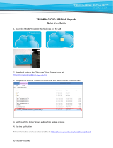
Mounting a Cloud Drive
J-Field supports Google Drive and Dropbox cloud drives.
Files>Browse Files screen showing mounted Google Drive,
Dropbox and a shared network folder.
To mount a cloud drive navigate to https://app.javad.com/
jca/#/inventory/devices and login from your PC’s browser.
If you have not setup a Javad.com login, you will need to
do so.

www.javad.comwww.javad.com
25
24 Files and Data Exhange Files and Data Exhange
Then enter the network path as shown above along with
your Windows account name and password.
Press OK and you should now see this folder shared in the
Root Directory where it can be used to import and export
les.
Note that if an error message is received while trying to read
the network shared folder, it may be necessary to reboot the
TRIUMPHLS to resolve this. This is a known issue with the
Windows operating system in the TRIUMPHLS.
Importing Points From a Text File
To import points from a text le open the Data Exchange
screen from the Home Screen 2 or from Files>Data Exchange.
Data Exchange Screen
Navigate to the location where your le is located using
the to go up a directory and Open to open a folder.
Then select and highlight the text le to open and choose
Open. (Notice the down arrow in the corner of the Navigate
Up button. Holding this button down will initiate a Long
Click and navigate to the system Root directory.)
Open File Screen - Filtered to show only text les
If your text le is congured with the standard format of
“PointName, N, E, H, Description” you should congure the
import settings as shown below if they are not presently
congured this way. The preview should display if the
format is being interpreted correctly.
If the preview is correct, press Next.

www.javad.comwww.javad.com
27
26 Files and Data Exhange Files and Data Exhange
A summary screen will be displayed. The points will be
imported into the selected Page and be imported to
the coordinate system of that Page. Tap Import to nish
importing the points.
Exporting Points To a Text File
To export points to a text le open the Data Exchange
screen and choose the Export option. Choose the format
of the le type you wish to export with the box in the lower
right corner, in this case Text/CSV. Navigate to folder you
wish to save the le. Click the Next button to proceed or
enter a new le name if desired. If you desire to change the
default lename of the le to be created, you may do so by
clicking on the lename box displayed to the right of Save
File in This Folder.
Save File Screen - Set to save a txt le in the USB drive
The Export Formatting screen will be displayed. It should
have the default conguration to export a “PointName, N, E,
H, Description” le with the description eld being a merged
eld J-Field’s Code, Attributes and Description elds. These
elds are merged together with the use of Sep. 2 (Separator
2) set to be a space. By default, elds are separated with
Sep. 1, typically set to be a comma. Highlighting a eld from
the box on the left side of the screen and tapping Sep. 2 will
add a plus sign after the eld name to indicate that it will be
separated with Sep. 2.
Export Formatting Screen with Default Formatting Shown
The plus and minus buttons are used to add and remove
elds while the up and down arrows will change the
order of elds. Presets allows congurations to be saved
and recalled. Options are displayed to set the number of
Decimals exported and whether to export a Header Line.
More Settings opens the Export CSV Settings screen where
options exist to specify how to format cut and ll values and
Surveyed Design Points.
Export CSV Settings Screen
Use Export Range to choose which points to export.
What to Export Screen
After the settings and points to export have been selected,
tap Next to preview the formatting and points before
pressing Export to create the le.
Export File Preview Screen

www.javad.comwww.javad.com
29
28 Files and Data Exhange ShapeTags & Codes
Exporting Photos, Screenshots, GNSS
Data and Project Archives
To export media les that include photos, screenshots,
audio les and raw GNSS data les choose the Project
Archive File (ZIP) format option in the Save File screen. A
full Project Archive can also be exported with this option. A
Project Archive contains all the les necessary to restore the
project if it becomes corrupt or deleted. It can also be used
to copy the project to a dierent TRIUMPH-LS.
Save File Screen - Set to save a Project Archive le in the USB
drive
After tapping Save File in This Folder or the New button you
will be presented with options to specify what type of les
to export in the Export Project Archive screen. Use the Full
option to create a backup that can be restored. The Only
Media option will export only the letypes chosen. Press
Create to export the les which will all be contained in a zip
le.
Export Project Archive Screen - Set to export only photos
(screenshots included) and raw GNSS les
Exporting A Project Report
A report of the Project can be exported in HTML or PDF
format by choosing HTML or PDF format in the Save File
screen. The report will contain the selected points with
all the details and statistics about that point. The Text &
Images will be included if this option is checked. A number
of options exist to format the PDF or HTML report:
ShapeTags &
Codes
Create and manage your
own library of Codes; alpha-
numeric textual assignments
to points. Codes can quickly be recalled from the Favorite
Codes screen, eliminating the need to type in a point
description for each surveyed point. In addition, each Code
can have up to ve Code Attributes elds. An example of
a Code is “IPF” (Iron Pin Found). It can then be setup with
Code Attribute elds of “Size”, “Cap” and “Status” which allow
these attributes to be entered and stored with each point.
Choose Tags & Codes>Manage Codes to access the library of
Codes.
Manage Codes Screen
Tap Create or Edit to make a new Code or edit an existing
one. A Symbol, ID, Category and Code Description can be
assigned each Code. If a Symbol is associated with a Code,
points with that code will have the Symbol displayed on
the map. The ID eld is a numerical eld that is not used
in J-Field but is an export option for text les and may be
useful with other software packages. The Category can be
used as a lter in the Manage Codes screen.
Edit Code Screen
ShapeTags can be assigned to points during data collection
to enable the automated drawing of lines between points
with like ShapeTags. For example, you may want to create a
ShapeTag of “Fence”. When collecting a point along a fence,
select the “Fence” ShapeTag to be assigned with that point.
This will cause a line to be drawn on the map between
that point and the previous point that also has the “Fence”
ShapeTag.
ShapeTags are associated with a chosen Code when a new
ShapeTag is created. When a ShapeTag is then selected to be
assigned to a point, by default, the Code eld for that point
will be populated with the associated Code.

www.javad.comwww.javad.com
31
30 Setup Setup
Setup
J-Field’s settings are divided
into 3 prole groups: the
General Group, Action Group
and Favorite ShapeTags and
Codes. These groups exist
so that dierent settings
groups can quickly and
easily be saved and recalled.
The General Group prole stores the settings for RTK
corrections, i.e. the congurations for UHF radios or
connection parameters to a RTN. The Advanced Settings are
also stored in the General Group and are found as an option
in the rst setup screen of the General Group, they include
the settings for the displayed units. Tap Edit>Advanced to
access them.
The (Set Up) will quickly open the Setup screen;
pressing it twice opens the Advanced Settings Screen.
As an example, to congure a new RTN setup you would
tap Create to create a new General Group prole and then
follow the screen prompts to enter the communication
parameters and settings. See Appendix A: Creating a RTN
Prole for detailed instructions on setting up a RTN. Copy
As creates a copy of the existing prole but prompts you to
enter a new name for the new prole.
Setup Screen
Advanced Settings Screen
Tapping the Recall / Manage button will open a list of
proles shown on the left side of the Proles screen. Details
of that prole are displayed in the information panel (the
blue box on the right side of the screen). Across the top
from left to right are buttons to Rename, Delete, Search,
Sort Alphabetically, Sort by Date.
General Group Proles Screen
The Action Group prole contains the collection settings.
These include the RTK Verication and Validation settings
and how many epochs to collect. These settings are
discussed in the Collect section of this manual. The
conguration of the Stake and Collect Action screens’ User
Dened (whitebox) Buttons are stored in the Action Group
prole as well as the U1-U4 hardware button options.
Action Setup Screen
The Favorite ShapeTags & Codes prole stores dierent list
of favorite ShapesTags and Codes.
Setup Favorite ShapeTags & Codes Screen

Base/Rover Setup
www.javad.comwww.javad.com
33
32 Base/Rover Setup Base/Rover Setup
Setup Screen - Creating a new General Group prole
Enter a prole name (“UHF” or “FH915 SS” are suggested) in
the next screen and tap OK. The next screen will prompt
you to select the Operating Mode, choose RTK Rover:
You could tap Next and continue to congure all the
communion parameters but this is not necessary as they
can also be congured with Base/Rover Setup. Press Back
and then Esc to return to the Home screen.
Base/Rover Setup
Base/Rover Setup is used to congure and start the
transmission of RTK corrections via UHF or FH915 SS
(frequency hopping spread spectrum) radios from your
Javad Base receiver and radio to your Rover. It reads the
communication parameters from a UHF or SS General Group
rover prole and creates a matching base station prole
internally. It then sends that base station prole to the base
through the Bluetooth connection.
Before Base/Rover Setup can be used a UHF or FH915 SS
General Group rover prole is needed. If one does not exist
yet, open the Setup screen and tap Create for a new General
Group prole:
Once a UHF or FH915 SS General Group prole has been
created and recalled, tap the Base/Rover Setup button from
the second page of the Home screen.
If for some reason the selected prole is not in UHF or FH915
SS mode a message will be displayed indicating so.
Should that be the case, tap Recall to select a UHF or FH915
SS radio prole or tap the displayed message to change the
current General Group prole into a UHF or FH915 SS prole.
To connect the Base and the Rover via Bluetooth, tap
on Connect. The external radio, if using one, should be
powered on prior to pressing Connect. Always have an
antenna connected to the radio before powering it on to
avoid potential damage to the radio.

www.javad.comwww.javad.com
35
34 Base/Rover Setup Base/Rover Setup
Immediately a scan of available Bluetooth devices will
begin and a few seconds later will be completed. If a base
station is found that has been previously used, J-Field will
automatically connect to it. If not, you will be presented
with a list and must choose the device intended to be used
as the Base receiver and tap Connect.
Once the Bluetooth connection has been initiated, it will
take a few seconds before it has completed. During that
interim few seconds, your screen may appear like what is
shown on the right.
Once the existing Base and radio parameters have been
retrieved the screen should look similar to this. The Rover
prole radio parameters are displayed on the left panel while
the current Base coordinate is displayed on the right. Radio
parameters displayed in red indicate that there is a dierent
value between the Base and Rover prole. Use From Base to
update the Rover prole to the parameters from the Base or
use To Base to send the Rover radio parameters to the Base
before starting the Base.
Tapping the left panel opens the screen to congure the
radio parameters. “RTCM 3.0 Min” Format should be used
to minimize the correction data that must be sent through
the radio.
To use 5 Hz BEAST MODE the Broadcast Period must be
changed to 0.2 seconds or Use Data UpSampling must
be enabled in the Advanced Setup menu (discussed at the
end of this section). It is important to note that increasing
the Broadcast Period, increases the battery consumption
of the radio as well as the heat generation inside it. With
the HPT435BT you may need to use the modem fan when
broadcasting with an output power greater than 4 watts
with 5 Hz corrections, depending upon the ambient
temperature. Data UpSampling is now preferred over 5
Hz corrections as it increases battery life and range of the
radios and decreases the heat generated from the radios.
The Base ID eld limits the Rover from receiving corrections
if the Base and Rover proles do not have the same Base ID.
It can be left at its default value of 0.
Transmit L2C is always enabled. If for some reason it is not
checked, it will become enabled automatically when the
Base is started with Base/Rover Setup.
To congure the UHF or FH915 parameters tap the UHF or
FH915 Conguration button.
UHF Base Conguration Screen
FH915 SS Base Conguration Screen

www.javad.comwww.javad.com
37
36 Base/Rover Setup Base/Rover Setup
Tapping the UHF or FH915 Conguration button will
trigger an immediate search for the radio via Bluetooth
between the Base and the radio. If a Bluetooth enabled
radio is not found to be currently paired to the Base, you
will be prompted to pair the radio. This can be done via
the Bluetooth option if the radio is currently not paired to a
base. If the radio was previously paired to a base, it would
need to be unpaired before it could be paired to another
base through the Bluetooth option. The USB option can
be used to pair a radio that is currently paired to a dierent
base by connecting the ratio to the TRIUMPH-LS through
the USB port.
For UHF radios the parameters shown to the right need
to be congured. The Frequency should be one of your
FCC licensed (US users) frequencies. A channel with
little interference should be chosen. From the Frequency
selection screen you can Scan the displayed channels to
check the interference levels.
A Modulation (the method the data is encoded in the radio
signal) must be selected that has a sucient link rate to
transmit the corrections. In the US Channel Bandwidth is
limited to 12.5 kHz the FCC and D16QAM modulation must
be used with a 5 Hz correction rate (0.2 second broadcast
period). D8PSK modulation should be used if the radio is
transmitting at 1 Hz. Modulations with greater link rates
have decreased receiver sensitivity to demodulate the
signal and the downside to choosing modulations with
higher link rates is that they are more subject to interference
and data loss when the signal is weak. Field test have found
that D16QAM modulation decreases the working range
of the radio approximately 20% as compared to DQPSK
modulation.
Increasing the Output Power increases radio range but
also increases radio power consumption. With an antenna
UHF Conguration Screen
height 4 m (13.1 ft), D16QAM modulation and a 1 watt
output power, 5 Hz RTK corrections can have a stable range
up to 4 km (2.5 miles) away when terrain obstacles do not
block the signal. A hill or ridge between the Base and Rover
will greatly limit the range. The FCC (US) allows up to 35
watts ERP (Eective Radiated Power) to be transmitted. If
you have a HPT435BT radio set to output 35 watts and are
using an antenna that isn’t a unity gain antenna, such as the
5 dBd gain whip antenna, you aren’t in conformance with
the FCC regulations and terms of your license. With the 5
dBd gain whip antenna, an Output Power of 10 watts or less
must be used to stay under 35 watts ERP.
Your FCC assigned call sign should be entered in the Call
Sign box.
The Unpair button is used to unpair the Bluetooth
connection between the base and Rover. This would only
be necessary if you wish to pair a dierent radio to your
Base.
Update FW checks and installs the latest radio rmware.
FH915 SS Radio Settings
With a FH915 SS radio Packet Repeating must be disabled
when using correction rates greater than 1 Hz.
In the US it may be best to operate on Channel 7 to avoid
interference.
Field test conrm 4 km (2.5 miles) as the range at which
stable 5 Hz RTK can be achieved with a FH915 SS radio with a
4 m (13.1 ft) antenna height. With 2 m you may achieve up to
2 km (1.2 miles), but it is dependent upon the environment.
FH915 SS Conguration Screen

www.javad.comwww.javad.com
39
38 Base/Rover Setup Base/Rover Setup
Return to main Base/Rover Setup screen by tapping OK
twice. Press To Base to send modied parameters to the
Base. After doing this all the parameter values should be
yellow.
The Base broadcast coordinate should now be set. Tap on
the coordinate pane on the right side of the screen.
If the base is being started on a known point select that point
From List or Enter the coordinates manually; otherwise use
an autonomous position by tapping From Auto.
The 2D Delta indicates the horizontal distance between the
current autonomous position the base is reporting and the
proposed broadcast coordinate.
Enter the Antenna Height and Oset. In this case the Base
is on a 2 m pole with the thread adapter that adds an
additional 0.025 m. Tap OK once done.
The base station raw GNSS data is always recorded and then
transfered to J-Field when Stop Base is pressed at the end
of a survey session so that it can be sent to Javad’s Data
Processing Online Service, also known as DPOS. With the
DPOS tool found in the CoGo menu and in the bottom of the
Base/Rover Setup screen, the raw data le can be submitted
to DPOS and all the survey points from that base station
session can be adjusted to their real coordinates so they are
no longer based o an autonomous position. The recording
interval can be specied along with some DPOS options
with the Rec box.
Once the coordinates for the Base have been selected/
entered along with Antenna Height and radio parameters
tap Start Base.
In this screen you can enter / change the name of the point
being used as the base; to do so, tap Stored Point Name
and enter the desired name. It is recommended the Project
Name being included in the point name so that the le can
easily be identied in the DPOS tool.
Conrm sending the coordinates to the Base with a tap on
Yes, Store Point and Send to Base.
The parameters will be sent to the Base and radio and the
Base should begin to broadcast, typically after about 80
seconds.
The (transmitting) icon will indicate when the Base
is transmitting and OK will be displayed to the right of it.
Similarly, the (receiving) icon will indicate when the
Rover is receiving data. If the icon bars are red (as shown
with one red bar), this indicates that the radio transmission
is over powering the receiving radio and that the Rover
is too close for set Output Power. If the broadcast is too
overpowering, corrections will be lost and the link quality
will drop.
/