Page is loading ...

All contents in this manual are copyrighted by JAVAD GNSS.
All rights reserved.The information contained herein may not be used, accessed, copied,
stored, displayed, sold, modified, published, or distributed, or otherwise reproduced without express
written consent from JAVAD GNSS.
TRIUMPH-1M
GNSS RECEIVER
User Manual
VERSION 1.2
LAST REVISED MAY 26, 2019

© JAVAD GNSS Inc., 2019
www.javad.com

www.javad.com 3
Table of Contents
PREFACE ..................................................5
TERMS AND CONDITIONS .......................5
WEEE DIRECTIVE ......................................6
SCREEN CAPTURES 6
TECHNICAL ASSISTANCE .........................6
REGULATORY INFORMATION...................6
FCC CLASS A COMPLIANCE ......................7
CANADIAN EMISSIONS LABELING
REQUIREMENTS .......................................7
RF EXPOSURE EVALUATION FOR MULTI-
TRANSMITTER PRODUCT PROCEDURES 7
CALCULATION OF POWER DENSITY AT A
GIVEN DISTANCE ......................................7
DESCRIPTION AND
OPERATION ..............................................9
INTRODUCTION .......................................9
SPECIFICATIONS ....................................10
GETTING ACQUAINTED ..........................11
MINPAD ..................................................11
TURNING ON/OFF ..................................12
CHARGING THE BATTERIES ...................12
POWER SUPPLY REQUIREMENTS ..........12
POWERING THE RECEIVER ....................13
SIM CARD SLOT ......................................13
DATA AND POWER PORTS......................13
EXTERNAL ANTENNA CONNECTOR
(OPTIONAL) ............................................14
ATTACHING UHF/GSM ANTENNA ..........14
MOUNTING ............................................14
CABLES ..................................................14
OPTION AUTHORIZATION FILE (OAF) ...14
MANAGING AND OPERATING RECEIVER
USING NETVIEW .....................................14
ESTABLISHING AN USB CONNECTION .15
ESTABLISHING A WIRELESS
CONNECTION .........................................15
CONFIGURING RECEIVER ......................15
MINPAD CONFIGURATION .....................18
FILE A, FILE B .........................................19
FUNCTION KEY.......................................19
AUTOMATIC FILE ROTATION MODE
(AFRM) ....................................................19
SETUP AND SURVEY ..............................20
MEASURE ANTENNA HEIGHT ................20
COLLECTING DATA .................................21
STATIC SURVEYING FOR BASE STATIONS .
21
KINEMATIC (STOP & GO) SURVEYING FOR
ROVER STATIONS ...................................21

4 www.javad.com
REAL TIME KINEMATIC SURVEYING .......22
RECEIVER AND FILE MAINTENANCE ......22
DELETING FILES AND DOWNLOADING
FILES TO A COMPUTER .........................23
MANAGING RECEIVER OPTIONS ............23
CHECKING AN OAF .................................23
LOADING OAFS .......................................23
CLEARING THE NVRAM ..........................23
USING MINPAD TO CLEAR NVRAM .........24
USING NETVIEW TO CLEAR NVRAM .......24
CHECKING FIRMWARE VERSION ...........24
LOADING NEW FIRMWARE .....................24
TROUBLESHOOTING .............................24
CHECK THIS FIRST! ................................24
RECEIVER PROBLEMS ............................24
TECHNICAL SUPPORT ...........................26

www.javad.com 5
Preface
Thank you for purchasing this product. The ma-
terials available in this Manual (the “Manual”) have
been prepared by JAVAD GNSS, Inc. (“JAVAD GNSS”)
for owners of JAVAD GNSS products. It is designed to
assist owners with the use of TRIUMPH-1M and its use
is subject to these terms and conditions (the “Terms
and Conditions”).
Please read these Terms and Conditions carefully.
TERMS AND CONDITIONS
USE – JAVAD GNSS receivers are designed to be
used by a professional. The user is expected to have
a good knowledge and understanding of the user and
safety instructions before operating, inspecting or
adjusting. Always wear the required protectors (safe-
ty shoes, helmet, etc.) when operating the receiver.
COPYRIGHT – All information contained in this
Manual is the intellectual property of, and copyright-
ed material of JAVAD GNSS. All rights are reserved.
You may not use, access, copy, store, display, create
derivative works of, sell, modify, publish, distrib-
ute, or allow any third party access to, any graphics,
content, information or data in this Manual without
JAVAD GNSS’ express written consent and may only
use such information for the care and operation of
your TRIUMPH-1M. The information and data in this
Manual are a valuable asset of JAVAD GNSS and are
developed by the expenditure of considerable work,
time and money, and are the result of original selec-
tion, coordination and arrangement by JAVAD GNSS.
TRADEMARKS – TRIUMPH-1M™, JAVAD GNSS® are
trademarks or registered trademarks of JAVAD GNSS.
Windows® is a registered trademark of Microso
Corporation; Bluetooth® word mark is owned by the
Bluetooth SIG, Inc. Product and company names
mentioned herein may be trademarks of their respec-
tive owners.
DISCLAIMER OF WARRANTY – EXCEPT FOR ANY
WARRANTIES IN THIS MANUAL OR A WARRANTY
CARD ACCOMPANYING THE PRODUCT, THIS MANUAL
AND THE TRIUMPH-1 RECEIVER ARE PROVIDED
“AS-IS.” THERE ARE NO OTHER WARRANTIES.
JAVAD GNSS DISCLAIMS ANY IMPLIED WARRANTY
OF MERCHANTABILITY OR FITNESS FOR ANY
PARTICULAR USE OR PURPOSE. JAVAD GNSS AND ITS
DISTRIBUTORS SHALL NOT BE LIABLE FOR TECHNICAL
OR EDITORIAL ERRORS OR OMISSIONS CONTAINED
HEREIN; NOR FOR INCIDENTAL OR CONSEQUENTIAL
DAMAGES RESULTING FROM THE FURNISHING,
PERFORMANCE OR USE OF THIS MATERIAL OR
THE TRIUMPH-1M RECEIVER. SUCH DISCLAIMED
DAMAGES INCLUDE BUT ARE NOT LIMITED TO LOSS
OF TIME, LOSS OR DESTRUCTION OF DATA, LOSS
OF PROFIT, SAVINGS OR REVENUE, OR LOSS OF
THE PRODUCT’S USE. IN ADDITION, JAVAD GNSS IS
NOT RESPONSIBLE OR LIABLE FOR DAMAGES OR
COSTS INCURRED IN CONNECTION WITH OBTAINING
SUBSTITUTE PRODUCTS OR SOFTWARE, CLAIMS BY
OTHERS, INCONVENIENCE, OR ANY OTHER COSTS. IN
ANY EVENT, JAVAD GNSS SHALL HAVE NO LIABILITY
FOR DAMAGES OR OTHERWISE TO YOU OR ANY OTHER
PERSON OR ENTITY IN EXCESS OF THE PURCHASE
PRICE FOR TRIUMPH-1M.
LICENSE AGREEMENT – Use of any computer pro-
grams or soware supplied by JAVAD GNSS or down-
loaded from a JAVAD GNSS website (the “Soware”) in
connection with TRIUMPH-1M constitutes acceptance
of these Terms and Conditions in this Manual and an
agreement to abide by these Terms and Conditions.
The user is granted a personal, non-exclusive,
non-transferable license to use such Soware under

6 www.javad.com
the terms stated herein and in any case only with a
single TRIUMPH-1M or single computer. You may not
assign or transfer the Soware or this license without
the express written consent of JAVAD GNSS. This li-
cense is eective until terminated. You may terminate
the license at any time by destroying the Soware and
Manual. JAVAD GNSS may terminate the license if you
fail to comply with any of the Terms or Conditions.
You agree to destroy the Soware and manual upon
termination of your use of TRIUMPH-1M. All owner-
ship, copyright and other intellectual property rights
in and to the Soware belong to JAVAD GNSS. If these
license terms are not acceptable, return any unused
soware and manual.
CONFIDENTIALITY – This Manual, its contents
and the Soware (collectively, the “Confidential
Information”) are the confidential and proprietary in-
formation of JAVAD GNSS. You agree to treat JAVAD
GNSS’ Confidential Information with a degree of care
no less stringent that the degree of care you would
use in safeguarding your own most valuable trade se-
crets. Nothing in this paragraph shall restrict you from
disclosing Confidential Information to your employ-
ees as may be necessary or appropriate to operate
or care for TRIUMPH-1M. Such employees must also
keep the Confidentiality Information confidential. In
the event you become legally compelled to disclose
any of the Confidential Information, you shall give
JAVAD GNSS immediate notice so that it may seek a
protective order or other appropriate remedy.
WEBSITE; OTHER STATEMENTS – No statement con-
tained at the JAVAD GNSS website (or any other web-
site) or in any other advertisements or JAVAD GNSS
literature or made by an employee or independent
contractor of JAVAD GNSS modifies these Terms and
Conditions (including the Soware license, warranty
and limitation of liability).
SAFETY – Improper use of TRIUMPH-1 can lead to
injury to persons or property and/or malfunction of
the product. The TRIUMPH-1 receiver should only be
repaired by authorized JAVAD GNSS warranty service
centers. Users should review and heed the safety
warnings in Appendix C.
MISCELLANEOUS – The above Terms and Conditions
may be amended, modified, superseded, or can-
celed, at any time by JAVAD GNSS. The above Terms
and Conditions will be governed by, and construed in
accordance with, the laws of the State of California,
without reference to conflict of laws.
WEEE DIRECTIVE
The following information is for EU-member states
only:
The use of the symbol indicates that this product
may not be treated as household waste. By ensuring
this product is disposed of correctly, you will help
prevent potential negative consequences for the en-
vironment and human health, which could otherwise
be caused by inappropriate waste handling of this
product. For more detailed information about the
take-back and recycling of this product, please con-
tact your supplier where you purchased the product
or consult.
SCREEN CAPTURES
This manual includes sample screen captures.
Your actual screen can look slightly dierent from
the sample screen due to the receiver you have con-
nected, operating system used and settings you have
specified. This is normal and not a cause for concern.
TECHNICAL ASSISTANCE
If you have a problem and cannot find the informa-
tion you need in the product documentation, contact
your local dealer. Alternatively, request technical sup-
port using the JAVAD GNSS World Wide Web site at:
www.javad.com
To contact JAVAD GNSS Customer Support use the
QUESTIONS button available on the www.javad.com
REGULATORY INFORMATION

www.javad.com 7
The following sections provide information on this
product’s compliance with government regulations.
FCC Class A Compliance
This device complies with Part 15 of the FCC rules.
Operation is subject to the following two conditions:
This device may not cause harmful interference,
and
This device must accept any interference received,
including interference that may cause undesired op-
eration.
This equipment has been tested and found to com-
ply with the limits for a Class A digital device, pursuant
to part 15 of the FCC Rules. These limits are designed
to provide reasonable protection against harmful in-
terference when the equipment is operated in a com-
mercial environment.
This equipment generates, uses, and can radi-
ate radio frequency energy and, if not installed and
used in accordance with the instruction manual, may
cause harmful interference to radio communications.
Operation of this equipment in a residential area is
likely to cause harmful interference in which case the
user will be required to correct the interference at his
own expense.
Canadian Emissions Labeling
Requirements
This Class А digital apparatus meets all re-
quirements of the Canadian Interference-Causing
Equipment Regulations.
Cet appareil numérique de la classe А respecte
toutes les exigences du Réglement sur le matériel
brouilleur du Canada.
RF EXPOSURE EVALUATION
FOR MULTI-TRANSMITTER
PRODUCT PROCEDURES
In mobile exposure conditions, simultaneous trans-
mission MPE test exclusion applies when the sum of
the MPE ratios for all simultaneous transmitting an-
tennas incorporated in a host device, based on the
calculated power density, is ≤ 1.0, i.e.
Where Si is the Power Density on the given distance
for i=1, 2, 3…..n,
n – number of antennas transmitting simultaneously,
(MPE)i is the Limit of MPE for the given transmit-
ting frequency.
The is the MPE ratio of each antenna, de-
termined at the minimum test separation distance re-
quired by the operating configurations and exposure
conditions of the host device, according to the ratio
of power density to MPE limit, at the frequency of in-
terest.
Calculation of Power Density at a given
distance
Power Density (S mW/cm2 ) is calculated as
Where
Pa– Average Power input to the antenna (in mW),
Pa= P×DC
DC – Source-based Duty Cycle (numeric)
G – gain of the antenna in the direction of interest
relative to an isotropic radiator (numeric),
d – distance to the center of radiation of the antenna
(in cm).
Regarding the Javad TRIUMPH-1M device contain-
ing multiple transmitters:
• UHF module (FCC ID: WJ4LMR400),
• 4G LTE Mini Card (FCC ID: N7NMC7700),
• Wi-Fi/Bluetooth Module (FCC ID: TFB-TIWI1-01),

8 www.javad.com
the following calculation of RF exposure compliance is performed:
Note: N7NMC7700 can transmit only in any one of four modes in time of operation. The worst case is transmitting in Cell band.

www.javad.com 9
Description and
Operation
INTRODUCTION
The new TRIUMPH-1M receiver inherits the best
features of our famous TRIUMPH-1. Based on our
new 864 channel chip, equipped with the internal 4G/
LTE/3G card, easy accessible microSD and microSIM
cards, includes “Li & Tilt” technology. (Fig. 1).
Figure 1. TRIUMPH-1M
TRIUMPH-1 can receive and processes multiple sig-
nal types (including the latest GPS C/A, P1, P2, L2C
(L+M); GLONASS C/A, L2C, P1, P2; SBAS L1) improv-
ing the accuracy and reliability of your survey points
and positions, especially under diicult jobsite con-
ditions.
Several other features, including multipath miti-
gation and common tracking, provide under-canopy
and low signal strength reception. The TRIUMPH-1
receiver provides the functionality, accuracy, avail-
ability, and integrity needed for fast and easy data
collection .
When calculating an absolute position, a stationary
or moving receiver determines its three-dimensional
position with respect to the origin of an Earth-Center
Earth-Fixed coordinate system. To calculate this po-
sition, the receiver measures the distance (called
pseudoranges) between it and at least four satellites.
The measured pseudoranges are corrected for clock
dierences (receiver and satellites) and signal prop-
agation delays due to atmospheric eects. The posi-
tions of the satellites are computed from the ephem-
eris data transmitted to the receiver in navigation
messages. When using a single satellite system, the
minimum number of satellites needed to compute
a position is four. In a mixed satellite scenario (GPS,
GLONASS, Galileo), the receiver must lock onto five or
more satellites to account for the dierent time scales
used in these systems and to obtain an absolute po-
sition.
Achieving quality position results requires the fol-
lowing elements:
Accuracy – The accuracy of a position primari-
ly depends upon the satellite geometry (Geometric
Dilution of Precision, or GDOP) and the measurement
(ranging) errors.
– Dierential positioning (DGPS and RTK) strong-
ly mitigates atmospheric and orbital errors, and
counteracts Selective Availability (SA) signals the US
Department of Defense transmits with GPS signals.
– The more satellites in view, the stronger the sig-
nal, the lower the DOP number, the higher position-
ing accuracy.
Availability – The availability of satellites aects
the calculation of valid positions. The more visible
satellites available, the more valid and accurate the
position. Natural and man-made objects can block,
interrupt, and distort signals, lowering the number
of available satellites and adversely aecting signal
reception.
Integrity – Fault tolerance allows a position to have
greater integrity, increasing accuracy. Several factors
combine to provide fault tolerance, including:
– Receiver Autonomous Integrity Monitoring (RAIM)
detects faulty GNSS satellites and removes them from
the position calculation.

10 www.javad.com
– Five or more visible satellites for only GPS or only
GLONASS; six or more satellites for mixed scenarios.
– Satellite Based Augmentation Systems (WAAS,
EGNOS, etc.) creates and transmit, along with DGPS
corrections, data integrity information (for example,
satellite health warnings).
– Current ephemerides and almanacs.
SPECIFICATIONS
Tracking Specifications
Signals tracked GPS C/A, P1, P2, L2C (L+M), L5 (I+Q);
Galileo E1 (B+C), E5A (I+Q), E5B (I+Q),
AltBoc;
GLONASS C/A, L2C, P1, P2, L3 (I+Q);
QZSS C/A, L1C(I+Q), L2C (L+M), L5 (I+Q),
SAIF;
Beidou B1, B2; SBAS L1, L5
Cold / Warm start/ Reacqui-
sition
<35 seconds/ <5 seconds/<1 second
Power Specifications
Battery Two internal Li-Ion batteries (7.4 V, 5.8 Ah
each) with internal charger
Operation Time Up to 18 hours
Input Voltage +10 to +30 volts
GNSS Antenna Specifications
GNSS Antenna Type Integrated Microstrip (Zero Centered)
Ground Plane Antenna on a flat ground plane
I/O
Communication Ports 2x serial (RS232) up to 460.8 kbps;
High speed USB 2.0 device port (480
Mbps);
Full-duplex 10BASE-T/100BASE-TX Ether-
net port;
Wi-Fi (IEEE 802.11b/g);
Bluetooth V2.0+EDR Class 2 supporting SPP
Slave Profile
External Power port 1 port
Radio Specifications
4G LTE Mini Card
LTE, HSPA+, HSDPA, HSUPA, WCDMA, GSM,
GPRS, EDGE (up to 100 Mbps)
LTE, EV-DO, 1xRTT CDMA (up to 100
Mbps)
MicroSIM card slot User accessible, fully sealed
Radio Modem Internal 406-470MHz UHF radio
Internal 902-928/ 868-870 MHz ISM radio
(optional)
Base Power Output 1 Watt
Memory and Recording
Internal Memory Up to 16 GB of on-board non-removable
memory for data storage
SD card slot High Capacity microSD Card (microS-
DHC) up to 32GB Class 10; user accessi-
ble,fully sealed
Raw Data Recording Up to 100 times per second (100Hz)
Real Time Data
Input/Output JPS, RTCM SC104 v. 2.x and 3.x, CMR
Output NMEA 0183 v. 2.x and 3.0, BINEX
Status Indicator Six LEDs, two function keys (MinPad)
Environmental
Enclosure Molded magnesium alloy and plastic,
waterproof IP67
Operating /Storage
Temperature
-30° C to +55° / -20° C to +45° C
Humidity 100% condensing
Shock Survives a 2 m drop onto hard surface
Dimensions 7 x 3.78 x 7 in (178 x 96 x 178 mm)
Weight 3.75 lbs (1.7 kg)/4.02 lbs (1.82 kg) with
modem antenna

www.javad.com 11
1
1. SIM-card slot
2. Mounting
3. On/O button
4. LEDs
5. FN button
6. Connectors
GETTING ACQUAINTED
The TRIUMPH-1M receiver’s advanced design re-
duces the number of cable required for operation,
allowing you to survey more reliably and eicient-
ly. The casing allocates space for two rechargeable
batteries, SIM card and SD card slots, a Bluetooth®
wireless technology module, a multi-system receiver
board, and a radio modem.
Figure 2. TRIUMPH-1M
Figure 3.
95.8*
277.8*
61.7*
5/8-11*
5/8-11*
25.4*
177.5*
183*
177.5*
183*
Dimensions in mm
MINPAD
The MinPad is the receiver’s minimum interface
used to display and control data input and output.
Figure 4. TRIUMPH-1М MinPad
The BAT (battery) LED displays the power status for
battery and receiver’s mode:
• No light - receiver is o/ no external power/sleep
mode is o
2
45
6
1
3

12 www.javad.com
• The LED color indicates the battery status:
• Green - greater than 85% charge.
• Yellow - an intermediate charge.
• Red - less than 15% charge.
Blinking every 1 sec according to the battery means
receiver is ON without external power. LED solid ac-
cording to the battery means external power is con-
nected.
The BT (Bluetooth) LED indicates the level of activ-
ity at the Bluetooth® wireless technology communi-
cation link:
• Blue – the Bluetooth® module is on and a con-
nection has been established.
• Yellow – the Bluetooth® module is on and a con-
nection is establishing.
• Red – connection is not established.
• No light – the Bluetooth® module is not active.
The WLAN LED displays the status of the WiFi con-
nection.
• Green – WLAN module is connected to access
point or adhoc mode is initialized correctly.
• Yellow – WLAN module is on and in process of ini-
tialization.
• Red – WLAN module error.
• No light – WLAN is not active.
The SAT (satellites) LED displays the number of
tracked satellites.
• Green – eight and more satellites.
• Yellow – five to seven satellites.
• Red – less than five satellites.
• No light – no satellites.
Eective number of satellites are total number of
satellites tracked minus the number of non-GPS sys-
tems tracked. E.g. if 8 GPS and 5 GLONASS are tracked
the eective number of satellites is 12.
The POS (position) LED indicates position solution
for current surveying mode:
• Green – Fixed/Di position solution is obtained.
• Yellow – Float/No-Di position solution is ob-
tained.
• Red – No position.
• No light - no satellites.
The REC (record) LED displays the data recording
status and blinks on each recording.
• Green – recording data.
• Yellow – less than 10 min memory le.
• Red – memory is full.
• No light - not active.
The On/O (power) button turns the receiver on
and o. The Record button starts/stops data record-
ing.
TURNING ON/OFF
To turn ON the receiver, press and hold the pow-
er button until the LEDs briefly flash. To turn OFF the
receiver, press and hold the power key for more than
one and less than four seconds (until both the SAT
and the REC LEDs are o).
CHARGING THE BATTERIES
Warning: Risk of explosion if battery is replaced by an incor-
rect type. Dispose of used battery according to the instructions.
Warning: Before beginning to work, fully charge the batteries
for maximum operating time. An approximately 6-hour charge cy-
cle will fully charge the batteries; the batteries will charge simulta-
neously. The batteries can not be overcharged.
CAUTION: RISK OF EXPLOSION IF BATTERY IS RE-
PLACED BY AN INCORRECT TYPE. DISPOSE OF USED
BATTERIES ACCORDING TO THE INSTRUCTIONS
Warning: The Li-Ion batteries used in the battery packs should
run at no less than 80% capacity after 500 charging cycles. These
batteries do not need to be drained before recharging.
Warning: Never attempt to open the casing of the detachable
batteries! Lithium-Ion batteries can be dangerous if mishandled!
Warning:
Warning: Do not incinerate or heat battery pack above 212 de-
grees Fahrenheit (100 degrees Celsius). Excessive heat can cause
serious damage and possible explosion.
Warning: The batteries (or batteries installed) shall not be ex-
posed to excessive heat such as sunshine, re or the like.
Warning: Do not attempt to open the battery pack.
Warning: Do not disassemble the battery pack.
Warning: Do not charge in conditions dierent than specied.
Warning: Do not use other than the specied battery charger.
Warning: Do not short circuit the battery pack.
Warning: Do not crush or modify the battery pack.
POWER SUPPLY
REQUIREMENTS
The socket-outlet shall be installed near the equip-
ment and shall be easily accessible.
A single external power supply with 5 pin ODU
connector or SAE connector is necessary to operate

www.javad.com 13
TRIUMPH-2. If external power supply has only SAE
connector, Receiver-to-SAE power cable shall be
used. The external power supply needs to be Listed
for US and Certified for EU countries, it needs also to
be a Limited Power Source and have an output rated
for 10...16 V DC, 3A. This may not be the same range as
other JAVAD GNSS products with which you are famil-
iar. To avoid the introduction of hazards when oper-
ating and installing, before connecting of the equip-
ment to the supply, make sure that the supply meets
local and national safety ordinances and matches the
equipment’s voltage and current requirements.
Figure 5. Power supply / Charger
Warning: Never attempt any maintenance or cleaning of the
supply while plugged in. Always remove supply from AC power
before attempting service or cleaning.
If the voltage supplied is below the minimum spec-
ification, the receiver will suspend operation. If the
voltage supplied is above the maximum specification,
the receiver may be permanently damaged, voiding
your warranty.
Make sure cords are located so that will not be
stepped on, tripped over, or otherwise subjected to
damage or stress. Do not operate equipment with a
damaged cord or plug – replace immediately. To re-
duce the risk of damage to the equipment, pull by the
plug body rather than the output cord when discon-
necting the equipment.
Warning: Do not operate the supply if it has received a sharp
blow, been dropped, or otherwise damaged. Do not disassemble
the supply.
Before connecting the external power source and
the receiver, make sure that the power source match-
es the receiver’s voltage and current requirements.
POWERING THE RECEIVER
To check the status of the internal batteries, view
the BAT LED or check the status using JAVAD GNSS
soware. Check the BAT LED for battery status.
To charge the receiver internal batteries, take the
following steps:
• Plug the Receiver-to-SAE cable’s connector into
the power port of the receiver (14-578125-01).
• Connect the opposite end of this cable with the
battery charger’-s SAE connector (22-570101-01).
• Plug the other end of this cable into an AC outlet
with cable (14-508053-01). Leave overnight.
SIM CARD SLOT
The SIM card slot allows a standard microSIM card
to be installed in the receiver. Once installed, the
SIM card provides a unique identification for the re-
ceiver’s GSM module and enables the receiver’s GSM
functionality based on the subscribed services (the
receiver board accesses the GSM module which ac-
cesses the SIM card). The SIM card usually remains
inside the receiver.
Note: A SIM card can be purchased from your local cellular
provider.
Figure 6. SIM-card slot
DATA AND POWER PORTS
• Power –is used to connect the receiver to an ex-
ternal power source. This port can also be used to
charge the batteries.
• Serial – is used for communication between the
receiver and an external device.
• Ethernet - is used to connect the receiver to local
network.
• USB – is used for high-speed data transfer and
communication between the receiver and an ex-
ternal device.

14 www.javad.com
Figure 7. Receiver’s ports
EXTERNAL ANTENNA
CONNECTOR (OPTIONAL)
The external antenna connects to the TNC external
antenna connector (optional).
ATTACHING UHF/GSM
ANTENNA
A broadband, rugged, in-building or outdoor an-
tenna designed to service the whole 406-470 MHz
UHF band and GSM quad band. With modest dimen-
sions of 25 mm (OD) x 182 mm (height), this antenna
radiates with a typical peak omnidirectional gain of
+1 dBi. Internally, the radiating element is DC shunted
to help protect the transceiver from nearby, but not
direct ElectroStatic Discharge (ESD).
The TRIUMPH-1M modem antenna can be mount-
ed on standard poles (5/8-11inches thread). Attached
to the 1 receiver this antenna gets a part of survey
pole, making handling with receiver easy and simple
MOUNTING
The bottom connector connects the receiver to ei-
ther a standard 5/8-11’’ mounting thread pole/adapt-
er or the quick disconnects.
CABLES
The TRIUMPH-1M receiver package includes stan-
dard communication and power cables for configur-
ing the receiver and providing a power source to the
receiver.
• Receiver-to-computer RS232 serial cable – con-
nects the receiver’s serial port and an external
device (hand-held controller or computer) p/n 14-
578103-01
• Receiver-to-SAE power cable – connects the re-
ceiver’s power port and the power supply’s SAE
connector or the extension cable’s SAE connector
p/n 14-578101-01
• SAE-to-SAE cable extension – connects SAE con-
nectors over longer distances p/n 14-578102-01
• Power supply with SAE connector p/n 22-570101-
01
• Cable Power/Charger Euro p/n14-508053-01/ Ca-
ble Power/Charger US p/n 14-508052-01
OPTION AUTHORIZATION
FILE (OAF)
JAVAD GNSS issues an Option Authorization File
(OAF) to enable the specific options that customers
purchase. An Option Authorization File allows cus-
tomers to customize and configure the TRIUMPH-1M
receiver according to particular needs, thus only pur-
chasing those options needed.
Typically, all TRIUMPH-1M receivers ship with a
temporary OAF that allows the receiver to be used for
a predetermined period of time. When the receiver is
purchased, a new OAF activates desired, purchased
options permanently. Receiver options remain intact
when clearing the NVRAM or resetting the receiver.
MANAGING AND OPERATING
RECEIVER USING NETVIEW
This soware is available on the JAVAD GNSS web-
site. If downloading the program(s) from the website,
extract the program’s files into a folder on your hard
drive. The following sections describe installing this
soware, and other sections throughout the manual
describe using this soware with the receiver.
Note: Refer to the NetView Software Manual for full details
on installing and using NetView Software.
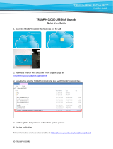
1. If downloading the program from the website,
extract the program files into a folder on your hard
drive.
2. Navigate to the location of the NetView program
and double-click the Setup.exe icon.
3. Follow the on-screen installation instructions.

www.javad.com 15
Click Install to continue. Keep the default installation
location or select a new location. If desired, create a
shortcut on the computer’s desktop for quick access
to NetView.
JAVAD GNSS NetView soware provides an inter-
face for various configuration, monitoring, and man-
agement functions for the receiver.
To configure, manage files, or maintain the receiv-
er, connect the receiver and a computer using one of
the following methods and start NetView:
• a USB cable and a computer/controller with the
JAVAD GNSS USB driver installed;
• a Bluetooth®-enabled external device (comput-
er/controller).
Once you have established a connection between
the receiver and the computer/controller, you will be
able to configure the receiver and its components,
send commands to the receiver, download files from
the receiver’s memory; as well as, upload new firm-
ware, upload an OAF, and upload configuration files
to a receiver, using NetView
Establishing an USB connection
Make sure the computer has JAVAD GNSS’s USB
driver installed (available from www.javad.com) be-
fore continuing.
Using the USB cable, connect the USB port on the
receiver to a USB port on the computer.
Press the power buttons on the receiver and com-
puter to turn them on.
Start NetView and select USB as type of connection
mode and select USB port ID from the list
Figure 8. NetView: USB connection
Establishing a Wireless Connection
The TRIUMPH-1M receiver contains Bluetooth®
wireless technology that allows file transfer and syn-
chronization between the receiver and any other ex-
ternal device that supports Bluetooth® wireless tech-
nology. TRIUMPH-1M and external device connection
procedure varies slightly depending on the type of
external device used.
Refer to your Bluetooth®-enabled external device documentation for more detailed
connection information.
In general, the connection procedure with PC is as fol-
lows:
1. Turn on a Bluetooth®-enabled PC and your receiv-
er. The default external device mode is Master; the re-
ceiver’s Bluetooth® module mode is Slave.
2. Instruct the external device (Master) to search for
the receiver (Slave).
3. Once the Master device detects the receiver, use
the procedure described in the external device’s doc-
umentation to connect it with the receiver.
4. Start NetView, select SER as type of connection
mode, and specify the port the receiver is connected
to
CONFIGURING RECEIVER
Both Base and Rover receivers must be configured
according to the desired survey method.
• In applications where real-time positioning re-
sults are required, the Base receiver provides the
correction information needed to properly cal-
culate the location of the Rover receiver. A Base
station is normally set up over a known point and
collects GPS/GLONASS data from satellites. As the
receiver picks up satellite data, it measures the
carrier and code phases to accurately compute
and verify its location. Then, the receiver transmits
this information via radio (UHF or GSM) to the Rov-
er receiver.
• The Rover receiver applies correction informa-
tion from the Base station to its current location
to accurately calculate one or more points. Rovers
are mobile GNSS receivers on a survey pole or bi-
pod that compares the information from the Base
station to the data it logs from satellites and ap-
plies correction algorithms to accurately calculate
a new point.
• In applications intended for post-processing, the
receivers typically log code phase and/or carrier
phase measurements separately from common
satellites and during the same time interval. This
data is then processed using post-processing so-
ware (for example, Justin).

16 www.javad.com
When configuring receivers for RTK surveying, use
the following list to ensure the receivers are properly
set up:
• Configure one receiver as an RTK Base station
and the other receiver as an RTK Rover.
• Configure the communication data link for trans-
mitting and receiving corrections.
• Set up the Base receiver over a known point to
begin collecting static observation data and trans-
mitting corrections. Set up the Rover receiver to
begin collecting RTK data.
When configuring receivers for post-processing
surveying, use the following list to ensure the receiv-
ers are properly set up:
• Configure one receiver as a Base station and the
other receiver as a Rover.
• Set up the Base receiver over a known point to
begin collecting static observation data. Set up the
Rover receiver to begin collecting static or kine-
matic observation data.
Both Base and Rover receivers must be configured
according to the desired survey method.
In applications where real-time positioning results
are required, the Base receiver provides the correc-
tion information needed to properly calculate the lo-
cation of the Rover receiver. A Base station is normally
set up over a known point and collects GPS/GLONASS
data from satellites. As the receiver picks up satellite
data, it measures the carrier and code phases to ac-
curately compute and verify its location. Then, the
receiver transmits this information via radio (UHF or
GSM) to the Rover receiver.
The Rover receiver applies correction information
from the Base station to its current location to accu-
rately calculate one or more points. Rovers are mo-
bile GNSS receivers on a survey pole or bipod that
compares the information from the Base station to
the data it logs from satellites and applies correction
algorithms to accurately calculate a new point.
In applications intended for post-processing, the
receivers typically log code phase and/or carrier
phase measurements separately from common satel-
lites and during the same time interval. This data is
then processed using post-processing soware (for
example, Justin).
The following Base and Rover configurations are
recommended for the most common applications.
However, you can select configuration parameters as
needed for your particular jobsite.
Note: Do not make other changes without consulting the Net-
View Software Manual.
1. Connect the receiver and computer, start NetView
and establish the connection as described above.
2. Click Receiver4Parameters on the le panel.
3. In the General tab check antenna status and set
the parameter Antenna Input to External if the external
antenna will be used.
4. Open the Log files tab and then TriPad tab and
set the following parameters, click Apply.
Note:
Parameter Base Rover
Implicit Message Output
Period
15 seconds
Elevation mask angle 15 degrees
File name prex Enter a unique ID, such as the last 3 digits
of receiver’s serial number. By deafault the
prex is log
FN key mode (starts/stops the data recording when FN
button is used)
Select LED blink
mode switch for
Static data
Select Occupation
mode switch (for
RTK)
Initial dynamic mode - Select Dynamic (for
trajectory survey)
Click Apply every time after the parameter was changed,
otherwise the receiver won’t save the changes. Click Refresh, to
ensure the changed parameters and new conguration are saved.
Figure 9. Log Files tab

www.javad.com 17
Figure 10. TriPad tab
5. Open Positioning tab and set the Elevation
mask to 15 degrees .
Figure 11. Elevation mask
6. To set up the base station, open the Base tab and
set the following parameters: Antenna Phase Center
Position (APC) - enter latitude, longitude, and altitude
(ellipsoidal height) values of the antenna position. Do
one of the following:
• If known, type in the values.
• Click Get from receiver to use the current antenna
position.
7. Restart your receiver. Open the Base tab and
check coordinates. Click Refresh, to refresh the pa-
rameters.
Figure 12. Base tab
7. To set up the rover, open Positioning tab and set
the Position Computation Mode - this drop-down list
box allows selecting the mode of position computa-
tion:
• pd -carrier phase dierential (RTK) with fixed
ambiguities
• pf - carrier phase dierential (RTK) with float am-
biguities
• cd- code dierential (DGPS) mode
• wd - wide area code dierential mode (WDGPS)
• sp - single point positioning mode1
Open the Rover tab and set up the following pa-
rameters:
• RTK Position Computation Mode – se-
lect Extrapolation for RTK float (kine-
matic), or Delay for RTK fixed (static).
If Extrapolation is selected, the rover will extrapo-
late the base station’s carrier phase measurements
when computing the rover’s current RTK position.
If Delay is selected, the rover will not extrapolate
the base station’s carrier phase measurements to
compute the current rover position. Instead, the
RTK engine will compute either a delayed RTK po-
sition (for the epoch to which the newly received
RTCM/CMR message corresponds) or the current
stand-alone position (while waiting for new RTCM/
CMR messages coming from the base).
• Confidence Level for Ambiguity – list box governs
the process of the RTK engine fixing integer ambi-
guities. The RTK engine uses the ambiguity fix indi-
cator when making a decision whether to fix ambi-
guities or not. Low, Medium and High correspond

18 www.javad.com
to the indicator’s 95%, 99.5% and 99.9% states,
respectively. The higher the specified confidence
level, the longer the integer ambiguity search time.
This is the price one pays for the higher reliability
of the ambiguity fixed solution.
Figure 13. Rover tab
9. For RTK survey, open the Ports tab and set up the
parameters according Table 2, then click Apply.
Note: For the survey with the post-processing keep default
parameters..
Figure 14. Ports tab
Parameter Base Rover
Input - The same correction type as
Base has
Output Select the correction type. -
Period (sec) Set the period of
correction output
-
Baud rate Baud rate for the corresponding receiver port
RTS/CTS Enable
10. Open Advanced tab, and then Multipath
Reduction subtab. Activate Code multipath reduction
(mpnew) on base and rover for DGPS mode.
For RTK mode activate Carrier multipath reduction
(mpnew) as well (mpnew).
Figure 15. Multipath Reduction
11. Click Apply, to save the made changes and
settings into receiver’s memory and close the dialog
window. The receiver configuration will be kept in the
receiver till you will change them or will clear NVRAM.
Note: For detailed description of settings and parameters see
NetView Software Manual..
MINPAD CONFIGURATION
The TRIUMPH-1M’s simple user interface (MinPad)
consists of two keys (Power and Record) and up to six
LEDs that control and display the receiver’s operation
(see Figure 3 on page 12).
The MinPad performs numerous functions:
• Turn the receiver on/o.
• Turn data recording on or o (Record button).
• Show the status of satellites being tracked (SAT
LED).
• Show data recording status (REC LED).
• Show each time data records to internal memory
(REC LED).
• Show the status of post-processing mode (static
or dynamic) when performing a Post-Processing
Kinematic measuring with the help of Record but-
ton (REC LED).
• Show the status of the battery (BAT LED).
• Show the power source for TRIUMPH-2 (BAT

www.javad.com 19
LED).
• Show the modem’s status (MOD LED).
• Show the Bluetooth® module status (BT LED).
• Show the position solution status (POS LED).
You use NetView to configure MinPad settings.
Refer to the NetView Soware Manual for all possible
MinPad configurations.
Connect the receiver and PC as described above.
Start NetView. Establish connection with the receiver.
Open TriPad tab. Set the following parameters and
click Apply:
• “File a, File b”
• “Function Key”
• “Automatic File Rotation Mode (AFRM)”
File a, File b
In the fields File a, File b can be specified current
log-file name, message output period, etc.
• Current log-file edit box allows the user to speci-
fy the prefix of the log file, which will be saved into
receiver memory during survey.
• In the Output Epochs Counter box the number of
outputted epochs is shown.
• In the Implicit Message Output Period edit box
the output period for the implicit messages can be
specified. This parameter specifies the interval of
outputting messages into the log-file when data
logging is activated with the TriPad or through the
AFRM.
• Elevation Mask for Measurements Output (the
minimum elevation angle for the satellites whose
data will be put in the receiver files logged when
pressing FN).
• Satellites Number Mask for Position computa-
tion - Satellites with elevations lower than this
mask will be excluded from position computation.
• File Name Prefix - this setting specifies what pre-
fix will be added to the names of the receiver files
created via MinPad, (i.e., by pressing FN). The pre-
fix can be up to 20 characters long. Default is log.
• Enable Implicit Management of Specific - en-
ables/disables the management of Implicit Mes-
sage Output Period.
Function Key
Figure 16. Funktion Key
• TriPad “FN” Button Action - This drop-down list
box is used to program how the receiver will react
to clicking FN (i.e., keeping the button depressed
for less than one (1) second). In led blink mode
switch mode, clicking FN will toggle between the
MinPad’s standard and extended information
modes. In occupation mode switch you click FN
to get the receiver to insert into the corresponding
log file a message indicating that the occupation
type has been changed from static to kinematic, or
vice versa.
• Turn Data Recording on at Startup - enables/dis-
ables data recording on at startup,
• Initial Dynamic Mode - specifies the starting oc-
cupation type descriptor that will be inserted at
the beginning of each receiver files logged via the
MinPad. You select static and kinematic to specify
that the corresponding log file will start with a stat-
ic and kinematic occupation, respectively.
• Appending data to a specific file - If the new re-
ceiver data are to be appended to an existing log
file, enter the desired filename in the Always ap-
pend to the file edit box. The setting can be up to
twenty characters long.
• Toggle Automatic Rotation Mode - enables/dis-
ables Automatic File Rotation Mode.
Automatic File Rotation Mode (AFRM)
Figure 17. AFRM
• Period – specifies the time duration of each of

20 www.javad.com
the multiple log files created in AFRM mode.
• Phase – specifies the phase (i.e., constant time
shi) of the multiple log files created in AFRM
mode.
• Enable Oldest Log-file removal – if active, the re-
ceiver will remove the least recent files if no free
space is available in the receiver memory to record
the current file
SETUP AND SURVEY
Aer configuring the receivers for surveying, each
receiver needs to be setup up and the receiver’s height
measured and the survey can begin. The MinPad pro-
vides quick access for logging data, changing receiver
modes, and viewing general data logging and satel-
lite information during a survey.
A typical GPS survey system consists of a Base sta-
tion set up over a known point and a Rover receiver
set up to be a mobile data collector. Aer setting up
the Base and Rover receivers, the antenna height
must be measured.
Before collecting data, make sure the Base and
Rover receivers contain a current almanac and cur-
rent ephemeris data.
The Base station must be set up, logging data, and
transmitting data before setting up the Rover receiv-
er. Receiver setup for either post-process or RTK sur-
veys is the same.
Measure Antenna Height
The location of the antenna relative to the point
being measured is very important for both surveys in
which the elevation of the points is important and in
surveys for horizontal location only. Horizontal sur-
veys are oen larger in area than can reliably fit on a
flat plane, therefore the antenna adjustment must be
done in three dimensions and then projected onto a
two dimensional plane.
The receiver calculates the coordinates of the an-
tenna’s phase center. To determine the coordinates of
the station marker, the user must specify the follow-
ing:
• Measured height of the antenna above the sta-
tion marker
• Method of measuring the antenna height
• Model of the antenna used
Antennas have two types of measurements:
• Vertical – measured from the marker to the an-
tenna reference point (ARP) located on the bottom
of the receiver at the base of the mounting threads.
• Slant – measured from the marker to the lower
edge of the antenna slant height measure mark
(SHMM) located on both end panels of the receiver.
The point to which surveying with GNSS measures
is called the Phase Center of the antenna. This is anal-
ogous to the point at which a distance meter mea-
sures in a prism. A user must enter the prism oset to
compensate for this point not being at a physical sur-
face of the prism. For a GNSS antenna, the oset is en-
tered depending on the type of measurement taken.
54.4
88.75
182*
L2 Up Offset: 90.77
L1 Up Offset: 89.19
236.4*
1. All dimensions are in mm
2. * Reference dimension
3. ARP - Antenna Reference Point
SHMP - Slant Height Measurement Point
NOM - North Orientation Mark
ARP
SHMP, NOM
For vertical, the oset is simply added to the mea-
sured vertical height to produce a “true” vertical
height.
For slant height, the vertical height must first be
calculated using the radius of the antenna, then the
oset can be added.
The osets are dierent because of the dierence
in location between the slant measuring point and
the vertical measuring point.
Measure the antenna height above the control
point or marker, either the slant height or the vertical
height.
Record the antenna height, point name, and start
/