Trimble Outdoors 332 User manual
- Category
- Dishwashers
- Type
- User manual
This manual is also suitable for

USER GUIDE
AgGPS
®
332 GPS Receiver
56370-00_332GPS_reciever_MC_7.25x9_0805.indd 1 15/08/2005 9:28:10 a.m.

www.trimble.com
Trimble Navigation Limited
Agriculture Business Area
7401 Church Ranch Blvd
Westminster, CO 80021
USA
+1-913-495-2700 Phone
Trimble Navigation Limited
Corporate Headquarters
935 Stewart Drive
Sunnyvale, CA 94085,
USA
+1-408-481-8000 Phone
Trimble Navigation Limited
Agriculture Business Area
Water Management Division
5475 Kellenburger Road
Dayton, Ohio, 45424-1099
USA
+1-937-233-8921 Phone
56370-00_332GPS_reciever_MC_7.25x9_0805.indd 2 15/08/2005 9:28:10 a.m.

Version 1.00
Revision A
Part number 56370-00-ENG
September 2005
USER GUIDE
AgGPS
®
332 GPS Receiver

Corporate Office
Trimble Navigation Limited
645 North Mary Avenue
PO Box 3642
Sunnyvale, CA 94085
USA
www.trimble.com
Legal Notices
© 2005, Trimble Navigation Limited. All rights
reserved.Trimble, the Globe & Triangle logo, AgGPS,
AutoPilot, and EZ-Guide are trademarks of Trimble
Navigation Limited registered in the US Patent and
Trademark Office and in other countries. EZ-Steer, Zephyr is
a trademark of Trimble Navigation Limited.
Recon is a trademark of Tripod Data Systems Inc., a wholly
owned subsidiary of Trimble Navigation Limited.
Microsoft, Windows, and ActiveSync are either registered
trademarks or trademarks of Microsoft Corporation in the
United States and/or other countries.
All other trademarks are the property of their respective
owners.
Release Notice
This is the September 2005 release (Revision A) of the AgGPS
332 GPS Receiver User Guide, part number 56370-00-ENG. It
applies to version 1.00 of the AgGPS 332 GPS receiver.
Limited Warranty Terms and Conditions
Product Limited Warranty
Subject to the terms and conditions set forth herein, Trimble
Navigation Limited (“Trimble”) warrants that for a period of
(1) year from date of purchase this Trimble product (the
“Product”) will substantially conform to Trimble's publicly
available specifications for the Product and that the
hardware and any storage media components of the Product
will be substantially free from defects in materials and
workmanship.
Product Software
Product software, whether built into hardware circuitry as
firmware, provided as a standalone computer software
product, embedded in flash memory, or stored on magnetic
or other media, is licensed and not sold. If accompanied by a
separate end user license agreement, use of any such
software will be subject to the terms of such end user license
agreement (including any differing limited warranty terms,
exclusions and limitations), which shall control over the
terms and conditions set forth in this limited warranty).
Software Updates
During the limited warranty period you will be entitled to
receive such Fix Updates and Minor Updates to the Product
software that Trimble releases and makes commercially
available and for which it does not charge separately, subject
to the procedures for delivery to purchasers of Trimble
products generally. If you have purchased the Product from
an authorized Trimble distributor rather than from Trimble
directly, Trimble may, at its option, forward the software Fix
Update or Minor Update to the Trimble distributor for final
distribution to you. Major Upgrades, new products, or
substantially new software releases, as identified by Trimble
are expressly excluded from this update process and limited
warranty. Receipt of software updates shall not serve to
extend the limited warranty period.
For purposes of this warranty the following definitions shall
apply: (1) “Fix Update” means an error correction or other
update created to fix a previous software version that does
not substantially conform to its published specifications; (2)
“Minor Update” occurs when enhancements are made to
current features in a software program; and (3) “Major
Upgrade” occurs when significant new features are added to
software, or when a new product containing new features
replaces the further development of a current product line.
Trimble reserves the right to determine, in its sole discretion,
what constitutes a significant new feature and Major
Upgrade.
Warranty Remedies
If the Trimble Product fails during the warranty period for
reasons covered by this Limited Warranty and you notify
Trimble of such failure during the warranty period, Trimble
at its option will repair OR replace the nonconforming
Product, OR refund the purchase price paid by you for the
Product, upon your return of the Product to Trimble in
accordance with Trimble's standard return material
authorization procedures.
How to Obtain Warranty Service
To obtain warranty service for the Product, please contact
your Trimble dealer. Alternatively, you may contact Trimble
to request warranty service at +1-408-481-6940 (24 hours a
day) or e-mail your request to [email protected].
Please be prepared to provide:
– your name, address, and telephone numbers
– proof of purchase
– this Trimble warranty card
– a description of the nonconforming Product including the
model number
– an explanation of the problem.
The customer service representative may need additional
information from you depending on the nature of the
problem.
Warranty Exclusions and Disclaimer
This Product limited warranty shall only apply in the event
and to the extent that (i) the Product is properly and
correctly installed, configured, interfaced, maintained,
stored, and operated in accordance with Trimble's applicable
operator's manual and specifications, and; (ii) the Product is
not modified or misused. This Product limited warranty shall
not apply to, and Trimble shall not be responsible for defects
or performance problems resulting from (i) the combination
or utilization of the Product with hardware or software
products, information, data, systems, interfaces or devices
not made, supplied or specified by Trimble;
(ii) the
operation of the Product under any specifica
tion other
than, or in addition to, Trimble's standard specifications for
its products; (iii) the unauthorized, installation, modification,
or use of the Product; (iv) damage caused by: accident,
lightning or other electrical discharge, fresh or salt water
immersion or spray; or exposure to environmental
conditions for which the Product is not intended; or (v)
normal wear and tear on consumable parts (e.g., batteries).
Trimble does not warrant or guarantee the results obtained
through the use of the Product. NOTICE REGARDING
PRODUCTS EQUIPPED WITH GPS TECHNOLOGY:
TRIMBLE IS NOT RESPONSIBLE FOR THE OPERATION OR
FAILURE OF OPERATION OF GPS SATELLITES OR THE
AVAILABILITY OF GPS SATELLITE SIGNALS.

THE FOREGOING LIMITED WARRANTY TERMS STATE
TRIMBLE'S ENTIRE LIABILITY, AND YOUR EXCLUSIVE
REMEDIES, RELATING TO PERFORMANCE OF THE
TRIMBLE PRODUCT. EXCEPT AS OTHERWISE EXPRESSLY
PROVIDED HEREIN, THE PRODUCT AND
ACCOMPANYING DOCUMENTATION AND MATERIALS
ARE PROVIDED “AS-IS” AND WITHOUT EXPRESS OR
IMPLIED WARRANTY OF ANY KIND, BY EITHER TRIMBLE
OR ANYONE WHO HAS BEEN INVOLVED IN ITS
CREATION, PRODUCTION, INSTALLATION, OR
DISTRIBUTION, INCLUDING, BUT NOT LIMITED TO, THE
IMPLIED WARRANTIES OF MERCHANTABILITY AND
FITNESS FOR A PARTICULAR PURPOSE, TITLE, AND
NONINFRINGEMENT. THE STATED EXPRESS
WARRANTIES ARE IN LIEU OF ALL OBLIGATIONS OR
LIABILITIES ON THE PART OF TRIMBLE ARISING OUT OF,
OR IN CONNECTION WITH, ANY PRODUCT.
SOME STATES AND JURISDICTIONS DO NOT ALLOW
LIMITATIONS ON DURATION OR THE EXCLUSION OF AN
IMPLIED WARRANTY, SO THE ABOVE LIMITATION MAY
NOT APPLY TO YOU.
Limitation of Liability
TRIMBLE'S ENTIRE LIABILITY UNDER ANY PROVISION
HEREIN SHALL BE LIMITED TO THE AMOUNT PAID BY
YOU FOR THE PRODUCT. TO THE MAXIMUM EXTENT
PERMITTED BY APPLICABLE LAW, IN NO EVENT SHALL
TRIMBLE OR ITS SUPPLIERS BE LIABLE FOR ANY
INDIRECT, SPECIAL, INCIDENTAL OR CONSEQUENTIAL
DAMAGE WHATSOEVER UNDER ANY CIRCUMSTANCE
OR LEGAL THEORY RELATING IN ANYWAY TO THE
PRODUCTS, SOFTWARE AND ACCOMPANYING
DOCUMENTATION AND MATERIALS, (INCLUDING,
WITHOUT LIMITATION, DAMAGES FOR LOSS OF
BUSINESS PROFITS, BUSINESS INTERRUPTION, LOSS OF
DATA, OR ANY OTHER PECUNIARY LOSS), REGARDLESS
OF WHETHER TRIMBLE HAS BEEN ADVISED OF THE
POSSIBILITY OF ANY SUCH LOSS AND REGARDLESS OF
THE COURSE OF DEALING WHICH DEVELOPS OR HAS
DEVELOPED BETWEEN YOU AND TRIMBLE. BECAUSE
SOME STATES AND JURISDICTIONS DO NOT ALLOW THE
EXCLUSION OR LIMITATION OF LIABILITY FOR
CONSEQUENTIAL OR INCIDENTAL DAMAGES, THE
ABOVE LIMITATION MAY NOT APPLY TO YOU.
PLEASE NOTE: THE ABOVE TRIMBLE LIMITED
WARRANTY PROVISIONS WILL NOT APPLY TO
PRODUCTS PURCHASED IN THOSE
JURISDICTIONS, SUCH AS COUNTRIES OF THE
EUROPEAN ECONOMIC COMMUNITY, IN WHICH
PRODUCT WARRANTIES ARE OBTAINED FROM
THE LOCAL DISTRIBUTOR. IN SUCH CASE, PLEASE
CONTACT YOUR TRIMBLE DEALER FOR
APPLICABLE WARRANTY INFORMATION.
Registration
To receive information regarding updates and new products,
please contact your local dealer or visit the Trimble website
at lwww.trimble.com/register. Upon registration you may
select the newsletter, upgrade or new product information
you desire.
Notices
Class B Statement – Notice to Users. This equipment has
been tested and found to comply with the limits for a Class B
digital device, pursuant to Part 15 of the FCC rules. These
limits are designed to provide reasonable protection against
harmful interference in a residential installation. This
equipment generates, uses, and can radiate radio frequency
energy and, if not installed and used in accordance with the
instructions, may cause harmful interference to radio
communication. However, there is no guarantee that
interference will not occur in a particular installation. If this
equipment does cause harmful interference to radio or
television reception, which can be determined by turning the
equipment off and on, the user is encouraged to try to correct
the interference by one or more of the following measures:
– Reorient or relocate the receiving antenna.
– Increase the separation between the equipment and the
receiver.
– Connect the equipment into an outlet on a circuit
different from that to which the receiver is connected.
– Consult the dealer or an experienced radio/TV technician
for help.
Changes and modifications not expressly approved by the
manufacturer or registrant of this equipment can void your
authority to operate this equipment under Federal
Communications Commission rules.
Canada
This digital apparatus does not exceed the Class B limits for
radio noise emissions from digital apparatus as set out in the
radio interference regulations of the Canadian Department
of Communications.
Le présent appareil numérique n’émet pas de bruits
radioélectriques dépassant les limites applicables aux
appareils numériques de Classe B prescrites dans le
règlement sur le brouillage radioélectrique édicté par le
Ministère des Communications du Canada.
Europe
This product has been tested and found to comply
with the requirements for a Class B device pursuant
to European Council Directive 89/336/EEC on EMC,
thereby satisfying the requirements for CE Marking and sale
within the European Economic Area (EEA). Contains
Infineon radio module ROK 104001. These requirements are
designed to provide reasonable protection against harmful
interference when the equipment is operated in a residential
or commercial environment.
Taiwan – Battery Recycling Requirements
The product contains a removable Lithium-ion
battery. Taiwanese regulations require that waste
batteries are recycled.
Notice to Our European Union Customers
For product recycling instructions and more information,
please go to www.trimble.com/environment/summary.html.
Recycling in Europe: To recycle Trimble WEEE
(Waste Electrical and Electronic Equipment,
products that run on electrical power.), Call +31 497
53 24 30, and ask for the "WEEE Associate". Or, mail
a request for recycling instructions to:
Trimble Europe BV
c/o Menlo Worldwide Logistics
Meerheide 45
5521 DZ Eersel, NL


AgGPS 332 GPS Receiver User Guide v
Contents
1 Introduction . . . . . . . . . . . . . . . . . . . . . . . 1
Welcome . . . . . . . . . . . . . . . . . . . . . . . . . . . . . . . . . . . . . . . . . . . .2
About the Product . . . . . . . . . . . . . . . . . . . . . . . . . . . . . . . . . . . . . .2
Related Information . . . . . . . . . . . . . . . . . . . . . . . . . . . . . . . . . . . . .2
Technical Assistance . . . . . . . . . . . . . . . . . . . . . . . . . . . . . . . . . . . . .2
Your Comments . . . . . . . . . . . . . . . . . . . . . . . . . . . . . . . . . . . . . . . .2
2 Overview . . . . . . . . . . . . . . . . . . . . . . . . . 3
Introduction . . . . . . . . . . . . . . . . . . . . . . . . . . . . . . . . . . . . . . . . . .4
Standard Features . . . . . . . . . . . . . . . . . . . . . . . . . . . . . . . . . .5
Receiver Connections . . . . . . . . . . . . . . . . . . . . . . . . . . . . . . . . . . . .6
Receiver Input/Output. . . . . . . . . . . . . . . . . . . . . . . . . . . . . . . . . . . .7
GPS Positioning Methods . . . . . . . . . . . . . . . . . . . . . . . . . . . . . . . . . .9
RTK GPS positioning . . . . . . . . . . . . . . . . . . . . . . . . . . . . . . . .9
Differential GPS positioning (DGPS). . . . . . . . . . . . . . . . . . . . . . 10
Autonomous GPS positioning . . . . . . . . . . . . . . . . . . . . . . . . . . 11
Sources of Error in GPS Positioning . . . . . . . . . . . . . . . . . . . . . . 12
Coordinate systems . . . . . . . . . . . . . . . . . . . . . . . . . . . . . . . . 14
Satellite DGPS mode status indicators . . . . . . . . . . . . . . . . . . . . 15
Receiver input / output . . . . . . . . . . . . . . . . . . . . . . . . . . . . . . 16
DGPS accuracy . . . . . . . . . . . . . . . . . . . . . . . . . . . . . . . . . . . 16
Receiving Beacon DGPS . . . . . . . . . . . . . . . . . . . . . . . . . . . . . 17
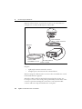
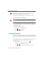
3 Connecting the Receiver . . . . . . . . . . . . . . . 19
Introduction . . . . . . . . . . . . . . . . . . . . . . . . . . . . . . . . . . . . . . . . . 20
System Components . . . . . . . . . . . . . . . . . . . . . . . . . . . . . . . . . . . . 20

Contents
vi AgGPS 332 GPS Receiver User Guide
Optional components . . . . . . . . . . . . . . . . . . . . . . . . . . . . . . . 20
Mounting the Receiver. . . . . . . . . . . . . . . . . . . . . . . . . . . . . . . . . . . 21
Choosing a location . . . . . . . . . . . . . . . . . . . . . . . . . . . . . . . . 21
Environmental conditions . . . . . . . . . . . . . . . . . . . . . . . . . . . . 22
Electrical interference . . . . . . . . . . . . . . . . . . . . . . . . . . . . . . . 22
Connecting to an External Device . . . . . . . . . . . . . . . . . . . . . . . . . . . 23
System Components . . . . . . . . . . . . . . . . . . . . . . . . . . . . . . . . . . . . 25
The receiver . . . . . . . . . . . . . . . . . . . . . . . . . . . . . . . . . . . . . 25
The antenna . . . . . . . . . . . . . . . . . . . . . . . . . . . . . . . . . . . . . 26
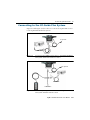
Routing and Connecting the Antenna Cable . . . . . . . . . . . . . . . . . . . . . 26
Connecting to the EZ-Guide Plus System . . . . . . . . . . . . . . . . . . . . . . . 29
Connecting to the EZ-Steer Assisted Steering System . . . . . . . . . . . . . . . 30
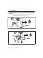
Connecting to a Laptop Computer . . . . . . . . . . . . . . . . . . . . . . . . . . . 31
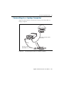
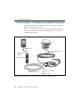
Connecting to a Windows Handheld Computer . . . . . . . . . . . . . . . . . . 32
4 Getting Started . . . . . . . . . . . . . . . . . . . . 33
Introduction . . . . . . . . . . . . . . . . . . . . . . . . . . . . . . . . . . . . . . . . . 34
Front Panel . . . . . . . . . . . . . . . . . . . . . . . . . . . . . . . . . . . . . . . . . . 34
Navigating the Menus and Screens . . . . . . . . . . . . . . . . . . . . . . . . . . . 35
Menu System Fields . . . . . . . . . . . . . . . . . . . . . . . . . . . . . . . . . . . . 37
Display-only fields . . . . . . . . . . . . . . . . . . . . . . . . . . . . . . . . . 37
Multiple-choice fields . . . . . . . . . . . . . . . . . . . . . . . . . . . . . . . 37
Text fields. . . . . . . . . . . . . . . . . . . . . . . . . . . . . . . . . . . . . . . 38
The Home Screen . . . . . . . . . . . . . . . . . . . . . . . . . . . . . . . . . . . . . . 39
Satellite DGPS mode. . . . . . . . . . . . . . . . . . . . . . . . . . . . . . . . 39
Satellite and SBAS DGPS mode . . . . . . . . . . . . . . . . . . . . . . . . . 40
Beacon DGPS mode . . . . . . . . . . . . . . . . . . . . . . . . . . . . . . . . 43
Updating the Firmware . . . . . . . . . . . . . . . . . . . . . . . . . . . . . . . . . . 44
5 Configuring the Receiver . . . . . . . . . . . . . . . 45
Introduction . . . . . . . . . . . . . . . . . . . . . . . . . . . . . . . . . . . . . . . . . 46
Home Screen . . . . . . . . . . . . . . . . . . . . . . . . . . . . . . . . . . . . . . . . . 46
Configuring Differential GPS . . . . . . . . . . . . . . . . . . . . . . . . . . . . . . . 47

Contents
AgGPS 332 GPS Receiver User Guide vii
OmniSTAR . . . . . . . . . . . . . . . . . . . . . . . . . . . . . . . . . . . . . . 47
WAAS/EGNOS . . . . . . . . . . . . . . . . . . . . . . . . . . . . . . . . . . . 48
Configuring the AgGPS Receiver to Operate in Beacon Mode . . . . . . . . . . 49
Configuring the AgGPS Receiver to Operate in RTK Mode . . . . . . . . . . . . 50
Configuring the Communication Ports . . . . . . . . . . . . . . . . . . . . . . . . 50
Configuring input/output communication. . . . . . . . . . . . . . . . . . 51
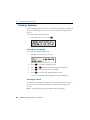
Display Options . . . . . . . . . . . . . . . . . . . . . . . . . . . . . . . . . . . . . . . 54
Installing Passcodes . . . . . . . . . . . . . . . . . . . . . . . . . . . . . . . . . . . . 56
FlashLoader200 utility. . . . . . . . . . . . . . . . . . . . . . . . . . . . . . . 57
6 Troubleshooting . . . . . . . . . . . . . . . . . . . . 59
Introduction . . . . . . . . . . . . . . . . . . . . . . . . . . . . . . . . . . . . . . . . . 60
Problems with GPS . . . . . . . . . . . . . . . . . . . . . . . . . . . . . . . . . . . . . 60
Interference Problems . . . . . . . . . . . . . . . . . . . . . . . . . . . . . . . . . . . 62
Problems with the GPS Receiver . . . . . . . . . . . . . . . . . . . . . . . . . . . . 63
Problems with the FlashLoader200 Utility . . . . . . . . . . . . . . . . . . . . . . 65
A Cables and Connectors . . . . . . . . . . . . . . . . 67
Introduction . . . . . . . . . . . . . . . . . . . . . . . . . . . . . . . . . . . . . . . . . 68
Port A and Port B Connectors . . . . . . . . . . . . . . . . . . . . . . . . . . . . . . 68
Standard Power/Data Cable . . . . . . . . . . . . . . . . . . . . . . . . . . . . . . . 69
B Specifications . . . . . . . . . . . . . . . . . . . . . 71
Introduction . . . . . . . . . . . . . . . . . . . . . . . . . . . . . . . . . . . . . . . . . 72
AgGPS 332 Receiver Physical Characteristics . . . . . . . . . . . . . . . . . . . . 72
GPS Channels Performance . . . . . . . . . . . . . . . . . . . . . . . . . . . . . . . 72
L-Band Satellite Differential Correction Receiver with OmniSTAR Support . 74
Receiver Default Settings . . . . . . . . . . . . . . . . . . . . . . . . . . . . . . . . . 74
DGPS Antenna. . . . . . . . . . . . . . . . . . . . . . . . . . . . . . . . . . . . . . . . 75
Dual-Frequency Antenna . . . . . . . . . . . . . . . . . . . . . . . . . . . . . . . . 75
Beacon Channels . . . . . . . . . . . . . . . . . . . . . . . . . . . . . . . . . . . . . . 75

Contents
viii AgGPS 332 GPS Receiver User Guide
C NMEA-0183 Messages . . . . . . . . . . . . . . . . . 77
Introduction . . . . . . . . . . . . . . . . . . . . . . . . . . . . . . . . . . . . . . . . . 78
NMEA-0183 Message Structure . . . . . . . . . . . . . . . . . . . . . . . . . . . . . 78
Symbols and delimiters . . . . . . . . . . . . . . . . . . . . . . . . . . . . . . 79
Checksum values . . . . . . . . . . . . . . . . . . . . . . . . . . . . . . . . . . 80
Field formats. . . . . . . . . . . . . . . . . . . . . . . . . . . . . . . . . . . . . 80
Null fields. . . . . . . . . . . . . . . . . . . . . . . . . . . . . . . . . . . . . . . 80
Talker ID codes . . . . . . . . . . . . . . . . . . . . . . . . . . . . . . . . . . . 80
Latitude and longitude values . . . . . . . . . . . . . . . . . . . . . . . . . . 81
Time values . . . . . . . . . . . . . . . . . . . . . . . . . . . . . . . . . . . . . 81
Reading NMEA string format . . . . . . . . . . . . . . . . . . . . . . . . . . 81
NMEA Message Summary . . . . . . . . . . . . . . . . . . . . . . . . . . . . . . . . 82
GGA (GPS Fix Data) . . . . . . . . . . . . . . . . . . . . . . . . . . . . . . . . . . . . 84
GLL (Position Data) . . . . . . . . . . . . . . . . . . . . . . . . . . . . . . . . . . . . 85
GRS (GPS Range Residuals). . . . . . . . . . . . . . . . . . . . . . . . . . . . . . . . 86
GSA (GPS DOP and Active Satellites) . . . . . . . . . . . . . . . . . . . . . . . . . 87
GST (GPS PRN) . . . . . . . . . . . . . . . . . . . . . . . . . . . . . . . . . . . . . . . 88
GSV (GPS Satellites in View) . . . . . . . . . . . . . . . . . . . . . . . . . . . . . . . 89
MSS (Beacon Receiver Signal Status). . . . . . . . . . . . . . . . . . . . . . . . . . 90
RMC (Recommended Minimum Specific GPS Data) . . . . . . . . . . . . . . . . 91
VTG (Course Over Ground and Ground Speed) . . . . . . . . . . . . . . . . . . . 93
XTE (Cross-Track Error). . . . . . . . . . . . . . . . . . . . . . . . . . . . . . . . . . 94
ZDA (Time and Date) . . . . . . . . . . . . . . . . . . . . . . . . . . . . . . . . . . . 95
PTNLEV Proprietary (Event Marker). . . . . . . . . . . . . . . . . . . . . . . . . . 96
PTNLID Proprietary (Trimble Receiver ID) . . . . . . . . . . . . . . . . . . . . . . 97
PTNLDG Proprietary (Trimble DGPS Receiver Status) . . . . . . . . . . . . . . 98
PTNL,GGK (Time, Position, Position Type, and DOP) . . . . . . . . . . . . . . 100
PTNLSM Proprietary (RTCM Special) . . . . . . . . . . . . . . . . . . . . . . . . 101
D Third-Party Interface Requirements . . . . . . . . 103
Software . . . . . . . . . . . . . . . . . . . . . . . . . . . . . . . . . . . . . . . . . . . 104
Hardware . . . . . . . . . . . . . . . . . . . . . . . . . . . . . . . . . . . . . . . . . . 105
Index . . . . . . . . . . . . . . . . . . . . . . . . . 109


1 Introduction
2 AgGPS 332 GPS Receiver User Guide
1.1 Welcome
This manual describes how to install and configure the Trimble
®
AgGPS
®
332 receiver.
Even if you have used other Global Positioning System (GPS) products
before, Trimble recommends that you spend some time reading this
manual to learn about the special features of this product. If you are not
familiar with GPS, visit the Trimble website (www.trimble.com) for an
interactive look at Trimble and GPS.
1.2 About the Product
The AgGPS 332 receiver is an innovative GPS receiver that provides “the
ultimate choice” for Agricultural GPS positioning. Scalable accuracy
levels allow the option of SBAS (Satellite Based Augmentation System),
Beacon, OmniSTAR-VBS/XP/HP, and RTK (Real-Time Kinematic). The
AgGPS 332 can provide the level of accuracy needed for any operation.
1.3 Related Information
Sources of related information include the following:
• Release notes – the release notes describe new features of the
product, information not included in the manuals, and any
changes to the manuals.
• Trimble training courses – Consider a training course to help
you use your GPS system to its fullest potential. For more
information, go to the Trimble website at
www.trimble.com/training.shtml.
1.4 Technical Assistance
If you have a problem and cannot find the information you need in the
product documentation, contact your local dealer.
1.5 Your Comments
Your feedback about the supporting documentation helps us to
improve it with each revision. E-mail your comments to
ReaderF[email protected]om.


2 Overview
4 AgGPS 332 GPS Receiver User Guide
2.1 Introduction
This chapter describes the AgGPS 332 receiver and gives an overview
of GPS, DGPS, and related information.
The AgGPS 332 receiver
combines high-performance GPS
reception with a DGPS-capable
receiver in a lightweight, durable
housing. The AgGPS 332 receiver
also contains the ultimate choice
in technology enabling
WAAS/EGNOS, OmniSTAR, or
Coast Guard Beacon Tower
real-time differential capabilities.
When used with a Real-Time
Kinematic (RTK) base station,
the AgGPS 332 receiver provides RTK positioning for high-accuracy,
centimeter-level applications. For physical specifications, see
Appendix B, Specifications..
You can use the receiver with a variety of farming equipment, including:
• AgGPS EZ-Guide
®
Plus lightbar guidance system
• AgGPS EZ-Steer
™
assisted steering system
• AgGPS Autopilot
™
automated steering system
• yield monitors
• variable-rate planters
• spray application controllers
• portable field computers for field mapping and soil sampling
• any device that requires a GPS input

AgGPS 332 GPS Receiver User Guide 5
Overview 2
21.1 Standard Features
A standard AgGPS 332 receiver provides the following features:
• 10 Hz (10 positions per second) output rate
• 12 GPS (C/A-code, L1and L2) tracking channels, code carrier
channels
• Submeter differential accuracy (RMS), assuming at least five
satellites and a PDOP (Position Dilution of Precision) of less than
four
1
(when used with SBAS correction)
• LED display
• Outputs a 1 PPS (pulse per second) strobe signal on both ports.
This signal enables an external instrument to synchronize its
internal time with a time derived from the very accurate GPS
system time.
• WAAS differential correction
2
• Beacon differential correction
2
• OmniSTAR VBS correction compatibility
• RTK positioning compatibility
• EVEREST
™
multipath rejection technology
• Two ports that support both CAN 2.0B and RS-232:
–CAN:
J1939 and NMEA 2000 messages
Note – The AgGPS 332 receiver is ISO 11783 compliant. It
supports some ISO 11783 messages.
– RS-232 :
NMEA-0183 output: GGA, GLL, GRS, GST, GSA, GSV, MSS,
RMC, VTG, ZDA, XTE (the default NMEA messages are
GGA, GSA, VTG, and RMC).
Note – PTNLDG, PTNLEV, PTNLGGK, PTNLID, and PTNLSM
are Trimble proprietary NMEA output messages.
RTCM SC-104 output.
Trimble Standard Interface Protocol (TSIP) input and
output.
1.
When used with SBAS correction.
2.
Where available.

2 Overview
6 AgGPS 332 GPS Receiver User Guide
2.2 Receiver Connections
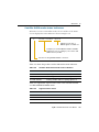
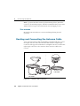
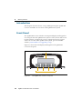
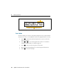
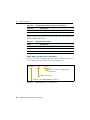
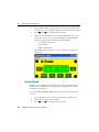
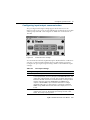
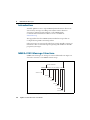
Figure 2.1 shows the connector ports on the AgGPS 332 receiver.
Figure 2.1 AgGPS 332 receiver connector ports
The two connectors (Port A and Port B) can perform the following
functions:
• accept power
• accept TSIP, RTCM, ASCII, and (if enabled) CMR inputs
• output RTCM, TSIP, and NMEA messages
• output 1 PPS signals
• provide support for the J1939 (CAN) serial bus
For more information about the inputs, outputs, and LCD display, see
the information in the rest of this section.

AgGPS 332 GPS Receiver User Guide 7
Overview 2
2.3 Receiver Input/Output
The AgGPS 332 receiver data/power cable (P/N 30945) connects to a
receiver connector port to supply power. It also enables the following
data exchanges:
• TSIP, RTCM, and ASCII input from an external device
The receiver is able to receive ASCII data from an external
device, convert this data into an NMEA message, and export the
message to another device. TSIP command packets configure
and monitor GPS and DGPS parameters. The receiver is also able
to accept RTCM data from an external device, such as a radio.
• CMR input from an external device
If the receiver is to be used in RTK mode, set the port that is
connected to the radio to the RtkLnk protocol. This protocol
enables the receiver to receive CMR messages.
• TSIP and NMEA output to an external device
When you are using an external radio, the receiver can also
receive DGPS corrections.
NMEA is output when the receiver is exporting GPS position
information to an external device, such as a yield monitor, or to a
mapping software program.
For more information on the National Marine Electronics
Association (NMEA) and Radio Technical Commission for
Maritime Services (RTCM) communication standard for GPS
receivers, go to the following websites:
– www.nmea.org
– www.rtcm.org
On the Trimble website (www.trimble.com), refer to the
document called NMEA-0183 Messages Guide for AgGPS
Receivers.

2 Overview
8 AgGPS 332 GPS Receiver User Guide
• 1 PPS output
To synchronize timing between external instruments and the
internal clock in the receiver, the connection port outputs a
strobe signal at 1 PPS (pulse per second). To output this signal,
the receiver must be tracking satellites and computing GPS
positions.
• J1939 (CAN) bus
Both connection ports on the receiver support the J1939
Controller Area Network (CAN) bus protocol. This protocol
standardizes the way multiple microprocessor-based electronic
control units (ECUs) communicate with each other over the
same pair of wires. It is used in off-highway machines, such as
those used in agriculture, construction, and forestry.
For more information, go to the Society of Automotive Engineers
(SAE) International website at www.sae.org/servlets/index.
• ISO 11783 messages
Both CAN ports support some ISO 11783 messages.
Position output format
The AgGPS receiver outputs positions in Degrees, Minutes, and
Decimal Minutes (DDD°MM.m'). This is the NMEA standard format
and is commonly used worldwide for data transfer between electronic
equipment.

AgGPS 332 GPS Receiver User Guide 9
Overview 2
2.4 GPS Positioning Methods
GPS positioning systems are used in different ways to provide different
levels of accuracy. Accuracy is measured in absolute terms (you know
exactly where you are in a fixed reference frame).
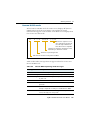
Table 2.1 summarizes the GPS positioning methods. Imperial units in
this table are rounded to two decimal places. The values shown are
2sigma.
For more information about each positioning method, see below.
24.1 RTK GPS positioning
The AgGPS 332 receiver uses the RTK positioning method to achieve
centimeter-level accuracy. To use the RTK method, you must first set
up a base station. The base station uses a radio link to broadcast RTK
corrections to one or more rover receivers. The AgGPS 332 receiver is a
rover receiver, so another compatible receiver, such as a Trimble
MS750
™
or AgGPS 214 GPS receiver, must be used as the base station.
Table 2.1 Absolute accuracy of GPS positioning method
GPS positioning
method
Corrections used Approximate absolute accuracy
Real-Time Kinematic
(RTK) GPS
Trimble CMR
corrections broadcast
by a local base station
2.5 cm (0.98 in) + 2 ppm horizontal accuracy,
3.7 cm (1.46 in) + 2 ppm vertical accuracy
OmniSTAR HP
Differential GPS
OmniSTAR HP 10 cm (3.94 in) after the signal has fully
converged
1
1
Convergence time can vary, depending on the environment. Time to the first fix (submeter accuracy) is
typically <30 seconds; time to the first high accuracy fix (<10 cm accuracy) is typically <30 minutes.
OmniSTAR XP
Differential GPS
20 cm (7.87 in) after the signal has fully
Differential GPS converged
Satellite Differential GPS OmniSTAR VBS 78 cm (30.71 in)
Radio Beacon Coast Guard radio
beacon towers
.4 inch through 12 inch
(10 cm through 30 cm) RMS 15 min
Satellite Differential GPS WAAS/EGNOS 95 cm (37.40 in)

2 Overview
10 AgGPS 332 GPS Receiver User Guide
A transmitter in the base station sends the corrections through a radio
link to the rover radio, which sends the corrections to the AgGPS 332
receiver. The rover receiver uses RTK corrections from the base station
to calculate its position to centimeter-level accuracy. As part of this
process, the rover receiver must calculate an initialization. This takes a
few seconds. While the receiver is initializing, an RTK Float solution is
generated. Once initialized, an RTK Fixed solution is generated. It is the
RTK Fixed solution that provides centimeter-level accuracy.
The parts per million (ppm) error is dependent on the distance
(baseline length) between the base and rover receiver. For example, if
the distance is 10 km, a 2 ppm error equals 20 mm.
For more information about RTK positioning, go to the Trimble website
at www.trimble.com/gps/.
24.2 Differential GPS positioning (DGPS)
For differential positioning, the AgGPS 332 receiver uses corrections
from SBAS (WAAS/EGNOS)/OmniSTAR satellites and Radio Beacons.
These differential systems use special algorithms to provide differential
corrections that allow the rover receiver to calculate its position more
accurately.
Free corrections
WAAS/EGNOS corrections are free in North America and Europe.
For more information about WAAS, go to the Federal Aviation
Administration website at
http://gps.faa.gov/Programs/WAAS/waas.htm.
For more information about EGNOS, go to the European Space Agency
website at
www.esa.int/export/esaSA/GGG63950NDC_navigation_0.html.
Radio Beacon corrections are available free worldwide. For more
information about the Coast Guard Beacon, go to
www.navcen.uscg.gov/Default.htm.
Page is loading ...
Page is loading ...
Page is loading ...
Page is loading ...
Page is loading ...
Page is loading ...
Page is loading ...
Page is loading ...
Page is loading ...
Page is loading ...
Page is loading ...
Page is loading ...
Page is loading ...
Page is loading ...
Page is loading ...
Page is loading ...
Page is loading ...
Page is loading ...
Page is loading ...
Page is loading ...
Page is loading ...
Page is loading ...
Page is loading ...
Page is loading ...
Page is loading ...
Page is loading ...
Page is loading ...
Page is loading ...
Page is loading ...
Page is loading ...
Page is loading ...
Page is loading ...
Page is loading ...
Page is loading ...
Page is loading ...
Page is loading ...
Page is loading ...
Page is loading ...
Page is loading ...
Page is loading ...
Page is loading ...
Page is loading ...
Page is loading ...
Page is loading ...
Page is loading ...
Page is loading ...
Page is loading ...
Page is loading ...
Page is loading ...
Page is loading ...
Page is loading ...
Page is loading ...
Page is loading ...
Page is loading ...
Page is loading ...
Page is loading ...
Page is loading ...
Page is loading ...
Page is loading ...
Page is loading ...
Page is loading ...
Page is loading ...
Page is loading ...
Page is loading ...
Page is loading ...
Page is loading ...
Page is loading ...
Page is loading ...
Page is loading ...
Page is loading ...
Page is loading ...
Page is loading ...
Page is loading ...
Page is loading ...
Page is loading ...
Page is loading ...
Page is loading ...
Page is loading ...
Page is loading ...
Page is loading ...
Page is loading ...
Page is loading ...
Page is loading ...
Page is loading ...
Page is loading ...
Page is loading ...
Page is loading ...
Page is loading ...
Page is loading ...
Page is loading ...
Page is loading ...
Page is loading ...
Page is loading ...
Page is loading ...
Page is loading ...
Page is loading ...
Page is loading ...
Page is loading ...
Page is loading ...
Page is loading ...
Page is loading ...
Page is loading ...
Page is loading ...
Page is loading ...
Page is loading ...
Page is loading ...
-
 1
1
-
 2
2
-
 3
3
-
 4
4
-
 5
5
-
 6
6
-
 7
7
-
 8
8
-
 9
9
-
 10
10
-
 11
11
-
 12
12
-
 13
13
-
 14
14
-
 15
15
-
 16
16
-
 17
17
-
 18
18
-
 19
19
-
 20
20
-
 21
21
-
 22
22
-
 23
23
-
 24
24
-
 25
25
-
 26
26
-
 27
27
-
 28
28
-
 29
29
-
 30
30
-
 31
31
-
 32
32
-
 33
33
-
 34
34
-
 35
35
-
 36
36
-
 37
37
-
 38
38
-
 39
39
-
 40
40
-
 41
41
-
 42
42
-
 43
43
-
 44
44
-
 45
45
-
 46
46
-
 47
47
-
 48
48
-
 49
49
-
 50
50
-
 51
51
-
 52
52
-
 53
53
-
 54
54
-
 55
55
-
 56
56
-
 57
57
-
 58
58
-
 59
59
-
 60
60
-
 61
61
-
 62
62
-
 63
63
-
 64
64
-
 65
65
-
 66
66
-
 67
67
-
 68
68
-
 69
69
-
 70
70
-
 71
71
-
 72
72
-
 73
73
-
 74
74
-
 75
75
-
 76
76
-
 77
77
-
 78
78
-
 79
79
-
 80
80
-
 81
81
-
 82
82
-
 83
83
-
 84
84
-
 85
85
-
 86
86
-
 87
87
-
 88
88
-
 89
89
-
 90
90
-
 91
91
-
 92
92
-
 93
93
-
 94
94
-
 95
95
-
 96
96
-
 97
97
-
 98
98
-
 99
99
-
 100
100
-
 101
101
-
 102
102
-
 103
103
-
 104
104
-
 105
105
-
 106
106
-
 107
107
-
 108
108
-
 109
109
-
 110
110
-
 111
111
-
 112
112
-
 113
113
-
 114
114
-
 115
115
-
 116
116
-
 117
117
-
 118
118
-
 119
119
-
 120
120
-
 121
121
-
 122
122
-
 123
123
-
 124
124
-
 125
125
-
 126
126


Trimble Outdoors 332 User manual
- Category
- Dishwashers
- Type
- User manual
- This manual is also suitable for
Ask a question and I''ll find the answer in the document
Finding information in a document is now easier with AI
Related papers
-
 Trimble Outdoors AgGPS 252 User manual
-
 Trimble Outdoors 132 User manual
-
 Trimble Outdoors R7/R8 User manual
-
 TRIMBLE SPSx5x User manual
-
 Trimble Outdoors 64057-00-ENG User manual
-
 Trimble Outdoors 5700/5800 User manual
-
 Trimble Outdoors CopernicusTM GPS Receiver User manual
-
 Trimble Outdoors JUNO ST handheld User manual
-
 Trimble Outdoors 5700 User manual
-
Trimble Outdoors Part Number 45005-00-ENG User manual


Other documents
-
 TRIMBLE EZ-Steer System User guide
-
 TRIMBLE SP SurveyPro User guide
-
 TRIMBLE SPS GPS Antennas User guide
-
Raven Phoenix 50 Installation & Operator's Manual
-
TRIMBLE R7 User guide
-
TRIMBLE Receivers Infrastructure User guide
-
 TRIMBLE JUP-8311891 User manual
-
 TRIMBLE Juno Series User guide
-
 TRIMBLE R6 User guide
-
 Struers Beacon User manual


