Garmin GPSMAP 550 User manual

Category
Car navigation systems
Type
User manual

Garmin GPSMAP 550: Navigate, explore, and capture your adventures with this versatile GPS device. Experience the outdoors like never before with its built-in 3.2-megapixel camera, allowing you to seamlessly capture and geotag photos during your journey. Explore new territories with the preloaded worldwide basemap and microSD card slot for additional map options. Stay on track with turn-by-turn navigation and a 3-axis compass, ensuring you're always headed in the right direction.

Garmin GPSMAP 550: Navigate, explore, and capture your adventures with this versatile GPS device. Experience the outdoors like never before with its built-in 3.2-megapixel camera, allowing you to seamlessly capture and geotag photos during your journey. Explore new territories with the preloaded worldwide basemap and microSD card slot for additional map options. Stay on track with turn-by-turn navigation and a 3-axis compass, ensuring you're always headed in the right direction.

P1 E&OE September 2009
Oregon 550
Rugged 3” touchscreen with built-in
3.2 megapixel camera
P2 E&OE September 2009
Oregon 550
Oregon 550
Oregon 550
Oregon 550 -
-Picture the great outdoors
Picture the great outdoors
P3 E&OE September 2009
Oregon platform with integrated 3.2 megapixel camera.
The Product
The Product
September 2009.
Availability
Availability
3.2MP auto-focus camera with 4x digital zoom.
Tap screen to capture image + capture waypoint.
Photo Navigation / High Speed USB / 3-axis compass.
Incl. 2 x AA NiMH Batteries + Charger.
What
What
s new?
s new?
Touch screen simplicity with camera and photo navigation.
Overview
Overview
850MBUSB / Serialmicro SDWW 3DYes3-axis
192.7g
w/batteries
6.3 cmTouchscreen
Oregon 550
Oregon 550
Display
Display
Size
Size Internal
Internal
Memory
Memory
Connectivity
Connectivity
Optional
Optional
Expandable
Expandable
Memory
Memory
Basemap
Basemap
Altimeter
Altimeter
Compass
Compass
Weight
Weight
Display type
Display type
Oregon 550
Oregon 550 -
-Overview
Overview
P4 E&OE September 2009
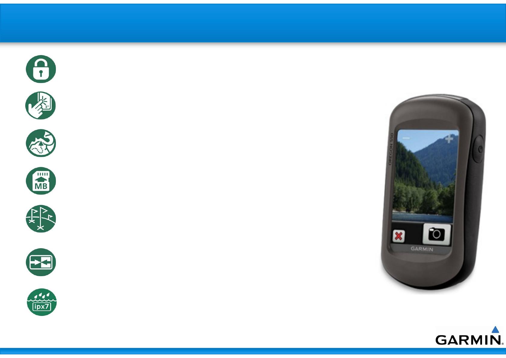
Oregon 550
Oregon 550 -
-Inherent Features
Inherent Features
Automotive-type user interface simplicity.
Including screen lock mechanism.
Rugged touchscreen operation with large 3“ high resolution, transflective
TFT colour display.
Turn by turn compatible.
3D Elevation view (with compatible map data)
Improved track navigation – no truncation.
Expandable memory via microSD card.
User configurable profiles – Automotive, Marine, Fitness, Recreation, Geocache.
Supports geocaching.com GPX files, displaying detailed cache info, including
terrain, difficulty, description & hints.
USB Connectivity.
For route planning, storage, analysis and sharing.
Wireless unit to unit data transfer and sharing.
Waterproof – IPX7
P5 E&OE September 2009
Oregon 5
Oregon 55
50
0 -
-Taking a photo
Taking a photo
Select the camera option
Tap camera icon
Tap camera icon
Simply tilt the Oregon 550 sideways to display in portrait / l
Simply tilt the Oregon 550 sideways to display in portrait / landscape
andscape
P6 E&OE September 2009
Oregon 5
Oregon 55
50
0 -
-Viewing a photo
Viewing a photo
Select the Photo Viewer option
Select photo
Select photo
Simply tilt the Oregon 550 sideways to display
in portrait / landscape
P7 E&OE September 2009
Oregon 550
Oregon 550 -
-HotFix
HotFix
HotFix – aka: Satellite Ephemeris Data Prediction
HotFix enabled Garmin units can predict satellite location for faster acquisition at
startup. It works by giving the restarted GPS device a head start by knowing where
to start looking for GPS satellites.
P8 E&OE September 2009
- DEM = Digital Elevation Model - A shaded relief terrain map
- Viewable when zoomed out of the 3D Mode - Helps with orientation
- Samples below are actual screen shots
Oregon 550
Oregon 550
DEM Mapping
DEM Mapping
P9 E&OE September 2009
Oregon 550
Oregon 550 -
-What
What
s In The Box?
s In The Box?
Oregon 550
USB Cable
Carabineer Clip
Rechargeable NiMH Battery Kit
Plus 2 AA NiMH batteries
Owner’s Manual On Disc
Quick Start Guide
P10 E&OE September 2009
Oregon 550
Oregon 550 -
-Comparison Chart
Comparison Chart
16 hour - 2 AA
Battery Life
Battery Life
9
Photo Navigation
Photo Navigation
9
Altimeter
Altimeter
9
Wireless Connectivity
9
Paperless Geocaches
Paperless Geocaches
9
Wherigo (GPS Game)
Wherigo (GPS Game)
8
8
8
9
Oregon 300
Oregon 300
9
9
3.2 megapixel
9(tilt-compensated,3-axis)
9
USB/Serial
microSD
850MB
Worldwide DEM
192.7 g
240 x 400
5.8 x 11.4 x 3.5 cm
Oregon 550
Oregon 550
Charger/Batteries
Charger/Batteries
Photo Geotagging
Photo Geotagging
Digital Camera
Digital Camera
Compass
Compass
High Sensitivity GPS
Interface
Interface
Expandable Memory
Expandable Memory
Internal Memory
Internal Memory
Basemap
Basemap
Weight w/Batteries
Weight w/Batteries
Screen Pixels
Screen Pixels
Unit Dimensions (cm)
P11 E&OE September 2009
Oregon 550 (P/N: 010-00697-10)
New product
New product
3.2MP auto-focus camera with 4x digital zoom
Tap screen to capture image + capture waypoint
Photo Navigation / High Speed USB / 3-axis compass
Incl. 2 x AA NiMH Batteries + Charger
What
What
s New
s New
Outdoor enthusiasts
Target market
Target market
Oregon 550
Oregon 550 -
-Product Summary
Product Summary
September 2009
Availability
Availability
P12 E&OE September 2009
Proudly Distributed by:
0861-GARMIN
  • Page 1 1
  • Page 2 2
  • Page 3 3
  • Page 4 4
  • Page 5 5
  • Page 6 6
  • Page 7 7
  • Page 8 8
  • Page 9 9
  • Page 10 10
  • Page 11 11
  • Page 12 12

Garmin GPSMAP 550 User manual

Category
Car navigation systems
Type
User manual

Garmin GPSMAP 550: Navigate, explore, and capture your adventures with this versatile GPS device. Experience the outdoors like never before with its built-in 3.2-megapixel camera, allowing you to seamlessly capture and geotag photos during your journey. Explore new territories with the preloaded worldwide basemap and microSD card slot for additional map options. Stay on track with turn-by-turn navigation and a 3-axis compass, ensuring you're always headed in the right direction.

Ask a question and I''ll find the answer in the document

Finding information in a document is now easier with AI