
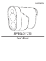
APPROACH® Z80
Owner’s Manual

© 2018 Garmin Ltd. or its subsidiaries
All rights reserved. Under the copyright laws, this manual may not be copied, in whole or in part, without the written consent of Garmin. Garmin reserves the right to change or improve its
products and to make changes in the content of this manual without obligation to notify any person or organization of such changes or improvements. Go to www.garmin.com for current updates
and supplemental information concerning the use of this product.
Garmin
®
, the Garmin logo, and Approach
®
are trademarks of Garmin Ltd. or its subsidiaries, registered in the USA and other countries. Garmin Express
™
is a trademark of Garmin Ltd. or its
subsidiaries. These trademarks may not be used without the express permission of Garmin.
Apple
®
is a trademark of Apple Inc., registered in the U.S. and other countries. Windows
®
is a registered trademark of Microsoft Corporation in the United States and other countries. Other
trademarks and trade names are those of their respective owners.

Table of Contents
Introduction.....................................................................1
Device Overview......................................................................... 1
Charging the Device................................................................... 1
Turning On the Device................................................................ 1
Standby Mode.............................................................................1
Status LEDs................................................................................ 1
Adjusting the Eyepiece............................................................... 2
Playing Golf.................................................................... 2
Measuring the Distance to the Pin.............................................. 2
Hole View....................................................................................2
Sight Something............................................................. 2
Measuring the Distance to a Target........................................... 2
Customizing Your Device.............................................. 3
Settings....................................................................................... 3
Device Information......................................................... 3
Device Care................................................................................ 3
Specifications..............................................................................3
Viewing E-label Regulatory and Compliance Information.......... 3
Troubleshooting............................................................. 3
Ranging Accuracy.......................................................................3
Acquiring Satellite Signals.......................................................... 3
My device cannot find nearby golf courses................................ 3
Restoring All Default Settings..................................................... 4
Product Updates......................................................................... 4
Getting More Information............................................................ 4
Index................................................................................ 5
Table of Contents i


Introduction
WARNING
See the Important Safety and Product Information guide in the
product box for product warnings and other important
information.
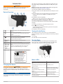
Device Overview
À
Press to open the menu and scroll through menu
options.
Á
Press to turn on the device.
Press to open the menu and scroll through menu
options.
Hold to turn off the device.
Â
Press to range with the laser. While playing golf, the
flag finder feature starts automatically.
Press to select menu options.
Ã
Adjustable
diopter
Rotate the eyepiece to focus the screen.
Ä
Status LED View device and battery status.
Å
Weather cap
Micro-USB
power and
data port
(under
weather cap)
Pull up to access the micro-USB power and data
port.
Connect a compatible USB cable to charge the
device or transfer data using your computer.
Æ
Device label View manufacturer's identification and certification.
Garmin 1200 E 151st St,
Olathe, KS 66062
CLASS 1 LASER PRODUCT
CLASSIFIED EN/IEC 60825-1 2014
This product is in conformity with
performance standards for laser
products under 21 CFR 1040,
except with respect to those
characteristics authorized by
Variance Number FDA-2016-V-2943
effective September 27, 2016.
S/N 5C9000000
Charging the Device
WARNING
This product contains a lithium-ion battery. To prevent the
possibility of personal injury or product damage caused by
battery exposure to extreme heat, store the device out of direct
sunlight.
NOTICE
To prevent corrosion, thoroughly dry the USB port, the weather
cap, and the surrounding area before charging or connecting to
a computer.
The device is powered by a built-in lithium-ion battery that you
can charge using a standard wall outlet or a USB port on your
computer.
NOTE: The device will not charge when outside the approved
temperature range (Specifications, page 3).
1
Pull up the weather cap from the USB port.
2
Plug the small end of the USB cable into the USB port on the
device.
3
Plug the large end of the USB cable into an external power
source, such as an AC adapter or a USB port on your
computer.
4
Charge the device completely.
TIP: You can turn off the device to charge it faster.
Saving Energy While Charging the Device
You can turn off the device screen and all other features while
charging.
1
Connect your device to an external power source.
2
Hold for 4 to 5 seconds.
The screen turns off, and the device goes into a low power,
battery charging mode.
3
Charge the device completely.
Turning On the Device
The first time you turn on the device, you are prompted to
choose a language, select a unit of measure, and set your driver
distance.
1
Press .
2
Follow the on-screen instructions.
Standby Mode
To conserve battery life, the device goes into standby mode
when not in use. The device wakes up when you hold it with
your thumb in the groove on the bottom of the device.
Status LEDs
LED Activity Status
Solid blue (for 5 seconds after turning
on)
The device is turned on.
Alternating red and blue (for 5 seconds
after turning on)
The battery is low.
Off The device is in active mode.
Slow flashing blue The device is in standby mode.
Solid red (after holding the power
button)
The device is turned off.
Rapid flashing red (connected to a
power source)
The device is charging in
energy-saving mode.
Solid blue and flashing red (connected
to a power source)
The device is charging.
Introduction 1

LED Activity Status
Solid red (connected to a power
source)
Charging is complete.
Slow flashing red A software update is in
progress.
Adjusting the Eyepiece
The device features an adjustable eyepiece (+/- 4 diopter
adjustment). This allows you to focus the screen for your
eyesight.
Rotate the eyepiece to focus the screen.
Playing Golf
Select Play Golf.
The device locates satellites and calculates your location.
The nearest course is selected, and the hole closest to your
current location is displayed automatically.
NOTE: You can select a course from the list if there is more
than one course near your current location.
Measuring the Distance to the Pin
You can use the flag finder feature to target the flag and
measure the distance from your current position to the pin. This
feature helps get an accurate distance to the pin by filtering out
other objects in the background.
1
Start playing a round of golf.
2
Align the rangefinder reticle with the flag.
NOTE: For best results, you should hold the device steady,
and align the reticle with the flag instead of the pin.
3
Press .
The measured range to the pin appears. A red arc appears
on the map at the laser-ranged distance. If the device is able
to target the flag, a flag icon appears, the distance arc is
yellow, and the hole view map automatically transitions to a
close up of the green.
TIP: You can return to the hole view by pointing the device
away from the green and pressing .
Hole View
The device shows the current hole you are playing, and
automatically transitions when you move to a new hole.
À
Displays distances to the beginning of the fairway, and the front and
back of hazards.
Á
Displays the current hole number.
Â
Displays the par for the current hole.
Ã
Displays distances to the front, center, and back of the green.
Ä
Displays layup distances to the center of the green.
The colors indicate distance in meters or yards: red is 100, white is
150, blue is 200, and yellow is 250.
Å
Displays your driver distance when you are on the tee box.
Viewing PlaysLike Distance
The "plays like" distance feature accounts for elevation changes
on the course by showing the adjusted distance to hazards and
the green. Distances ranged with the laser are also adjusted for
elevation changes.
1
Select or to open the menu.
2
Select PlaysLike Distances.
An icon appears next to each distance.
Distance plays longer than expected due to a change in
elevation.
Distance plays as expected.
Distance plays shorter than expected due to a change in
elevation.
Viewing the Direction to the Pin
The PinPointer feature is a compass that provides directional
assistance when you are unable to see the green. This feature
can help you line up a shot even if you are in the woods or in a
deep sand trap.
NOTE: Do not use the PinPointer feature while in a golf cart.
Interference from the golf cart can affect the accuracy of the
compass.
1
Select or to open the menu.
2
Select PinPointer.
The compass arrow points to the pin location. A cone
appears on the map to help orient you toward the pin.
TIP: You can press any key to return to the hole view.
Changing Holes
You can change holes manually from the hole view screen.
1
Select or to open the menu.
2
Select Change Hole.
3
Select an option.
Changing the Course
You can change the course manually from the hole view screen.
1
Select or to open the menu.
2
Select Change Course.
3
Select an option.
Ending a Round
1
Select or to open the menu.
2
Select Quit.
Sight Something
Measuring the Distance to a Target
You can use the device to measure the distance from your
current position to a target, such as on a driving range.
NOTE: The device can measure distances from 5 to 320 m (5.5
to 350 yd.).
1
Select Sight Something.
2
Align the rangefinder reticle with the target.
3
Press .
The measured range appears.
2 Playing Golf

Customizing Your Device
Settings
Select Settings.
Tournament Mode: Disables the PinPointer and PlaysLike
distance features. These features are not allowed during
sanctioned tournaments.
Driver Distance: Sets the average distance the ball travels on
your drive. This distance appears as an arc on the hole view
screen when you are on the tee box.
Compass Calibration: Allows you to manually calibrate the
compass sensor (Calibrating the Compass, page 3).
System: Sets system settings, such as the text language on the
device and the units of measure (System Settings,
page 3).
About: Displays device information, such as the unit ID,
software version, regulatory information, and license
agreement (Viewing E-label Regulatory and Compliance
Information, page 3).
Calibrating the Compass
NOTE: You must calibrate the electronic compass outdoors. Do
not stand near objects that influence magnetic fields, such as
cars, buildings, or overhead power lines.
Your device was already calibrated at the factory, and the
device uses automatic calibration by default. If the PinPointer
feature is not working properly, for example, after moving long
distances or after extreme temperature changes, you can
manually calibrate the compass.
1
Select Settings > Compass Calibration.
2
Follow the on-screen instructions.
System Settings
Select Settings > System.
Language: Sets the text language on the device.
NOTE: Changing the text language does not change the
language of user-entered data or map data.
Units: Sets the unit of measure for distance.
Restore Defaults: Resets all of the device settings to the
factory default values (Restoring All Default Settings,
page 4).
Device Information
Device Care
NOTICE
Do not store the device where prolonged exposure to extreme
temperatures can occur, because it can cause permanent
damage.
Avoid chemical cleaners, solvents, and insect repellents that can
damage plastic components and finishes.
Secure the weather cap tightly to prevent damage to the USB
port.
Cleaning the Device
NOTICE
Do not use a dry cloth to clean the lens. Use of a dry cloth may
damage the lens.
Avoid chemical cleaners and solvents that can damage plastic
components.
1
Wipe the outer casing and lens with a soft, non-scratch cloth
dampened with water or alcohol.
2
Wipe the outer casing dry, and allow the lens to air dry.
Long-Term Storage
When you do not plan to use the device for several months, you
should charge the battery to at least 50% before you store the
device. You should store the device in a cool, dry place with
temperatures around the typical household level. After storage,
you should fully recharge the device before using it.
Specifications
Battery type Rechargeable, built-in lithium-ion battery
Battery life Up to 15 hr. typical use
Water rating IEC 60529 IPX7*
Operating
temperature range
From -10º to 55ºC (from 14º to 131ºF)
NOTE: The device protects itself from
overheating and shuts down automatically if the
internal temperature exceeds the operating
temperature threshold.
Charging
temperature range
From 10º to 45ºC (from 50º to 113ºF)
*The device withstands incidental exposure to water of up to 1 m
for up to 30 min. For more information, go to www.garmin.com
/waterrating.
Viewing E-label Regulatory and Compliance
Information
The label for this device is provided electronically. The e-label
may provide regulatory information, such as identification
numbers provided by the FCC or regional compliance markings,
as well as applicable product and licensing information.
1
Select Settings.
2
Select About.
Troubleshooting
Ranging Accuracy
External factors may affect ranging accuracy, such as ambient
light, weather conditions, target reflectivity, and target size.
• The device can target longer ranges in lower light conditions,
such as on overcast days. Bright sunlight minimizes ranging
ability.
• Rain minimizes ranging ability.
• The device can target longer ranges when measuring the
distance to brightly colored, reflective, or shiny objects. Black
objects are less reflective, and can be targeted at shorter
ranges.
• Larger objects are easier to target than smaller objects. For
example, you should target the flag instead of the pin.
• The device can target longer ranges when the angle to the
target is closer to 90 degrees. A smaller angle to the target
limits ranging ability.
Acquiring Satellite Signals
The device may need a clear view of the sky to acquire satellite
signals. The time and date are set automatically based on the
GPS position.
1
Go outdoors to an open area.
The top of the device should be oriented toward the sky.
2
Wait while the device locates satellites.
It may take 30–60 seconds to locate satellite signals.
My device cannot find nearby golf courses
If a course update is interrupted or canceled before it completes,
your device may be missing course data. To repair missing
course data, you must update the courses again.
Customizing Your Device 3

1
Download and install course updates from the Garmin
Express
™
application (Product Updates, page 4).
2
Safely disconnect your device (Disconnecting the USB
Cable, page 4).
3
Go outside, and start a test round of golf to verify the device
finds nearby courses.
Disconnecting the USB Cable
If your device is connected to your computer as a removable
drive or volume, you must safely disconnect your device from
your computer to avoid data loss. If your device is connected to
your Windows
®
computer as a portable device, it is not
necessary to safely disconnect the device.
1
Complete an action:
• For Windows computers, select the Safely Remove
Hardware icon in the system tray, and select your device.
• For Apple
®
computers, select the device, and select File >
Eject.
2
Disconnect the cable from your computer.
Restoring All Default Settings
NOTE: This deletes all user-entered information.
You can reset all of the device settings to the factory default
values.
Select Settings > System > Restore Defaults.
Product Updates
On your computer, install Garmin Express (www.garmin.com
/express).
This provides easy access to these services for Garmin
®
devices:
• Software updates
• Course updates
• Product registration
Setting Up Garmin Express
1
Connect the device to your computer using a USB cable.
2
Go to www.garmin.com/express.
3
Follow the on-screen instructions.
Getting More Information
• Go to support.garmin.com for additional manuals, articles,
and software updates.
• Go to garmin.com/golf.
• Go to buy.garmin.com, or contact your Garmin dealer for
information about optional accessories and replacement
parts.
4 Troubleshooting

Index
A
accessories 4
B
battery 1
charging 1
storage 3
C
charging 1
compass 2
calibrating 3
courses
playing 2
selecting 2
customizing the device 3
D
device, care 3
display settings 2
distance, measuring 2
G
Garmin Express 4
updating software 4
golf round, ending 2
GPS, signal 3
green view, pin location 2
H
holes, changing 2
K
keys 1
M
maps, symbols 2
menu 1
P
pin location, green view 2
R
resetting the device 4
S
satellite signals 3
settings 1, 4
sleep mode 1
software, updating 4
specifications 3
system settings 3
T
troubleshooting 3, 4
U
USB, disconnecting 4
user profile 1
Index 5

support.garmin.com
April 2018
190-02355-00_0A
-
 1
1
-
 2
2
-
 3
3
-
 4
4
-
 5
5
-
 6
6
-
 7
7
-
 8
8
-
 9
9
-
 10
10


Garmin Approach Z80 Owner's manual
- Type
- Owner's manual
- This manual is also suitable for
Ask a question and I''ll find the answer in the document
Finding information in a document is now easier with AI
Related papers
-
Garmin Approach Z80 Owner's manual
-
-
Garmin 010-01914-00 Owner's manual
-
Garmin Approach Approach G8 Owner's manual
-
-
Garmin Approach® G8 Owner's manual
-
Garmin 010-02200-02 Owner's manual
-
-
-
Garmin Approach Z82 Owner's manual
Other documents
-
Protocol 8502-3 Golfer's Set User manual
-
PyleSport PMD58 Owner's manual
-
Pyle PMD64 Owner's manual
-
SereneLife SLGRF20SL Owner's manual
-
VOICE CADDIE SL2 User manual
-
 Cart-Tek GRX-1175R User manual
-
Bushnell Hybrid Laser GPS User manual
-
 VOICE CADDIE SL2 Active Hybrid GPS Laser Rangefinder User manual
-
 ProVisio S User manual
-
SereneLife AZSLGRF30SL Owner's manual


