Page is loading ...
GNC 300XL
Pilot’s Guide and Reference
300xl manual 1/25/99 2:34 PM Page i

300xl manual 1/25/99 2:34 PM Page ii

i
INTRODUCTION
Foreword
This manual is written for software version 2.04 or above, and is not suitable for
earlier software versions.
© 1999 GARMIN Corporation, 1200 East 151st Street, Olathe, Kansas 66062 USA
Tel: 913-397-8200 Fax: 913-397-8282
GARMIN (Europe) LTD, Unit 5, The Quadrangle, Abbey Park, Romsey, Hampshire S051 9AQ,
UK Tel: 011-44-1794-519944 Fax: 011-44-1794-519222
GARMIN (Asia) Corp., 4th Fl., No. 1, Lane 45, Pao-Hsing Road, Hsin Tien, Taiwan R.O. C.
Tel: 011-886-02-2917-3773 Fax: 011-886-02-2917-1758
Web Site Address: www.garmin.com
All rights reserved. No part of this manual may be reproduced or transmitted in any
form or by any means, electronic or mechanical, including photocopying and record-
ing, for any purpose without the express written permission of GARMIN.
Information in this document is subject to change without notice. GARMIN reserves
the right to change or improve their products and to make changes in the content of
this material without obligation to notify any person or organization of such changes
or improvements.
January 1999 190-00067-30 Rev. B Printed in USA
GARMIN, GNC 300XL, Spell’N’Find, AutoLocate,
PhaseTrac12, GPSCOM and AutoStore are
trademarks of GARMIN and may only be used
with permission.
NavData
®
is a registered trademark of
Jeppesen, Inc.
All rights reserved.
300xl manual 1/25/99 2:34 PM Page i

CAUTION
The Global Positioning System is operated by the United States government,
which is solely responsible for its accuracy and maintenance. The system is subject to
changes which could affect the accuracy and performance of all GPS equipment.
Although the GARMIN GNC 300XL is a precision electronic NAVigation AID
(NAVAID), any NAVAID can be misused or misinterpreted and therefore become
unsafe.
Use the GNC 300XL at your own risk. To reduce the risk of unsafe operation,
carefully review and understand all aspects of this Owner’s Manual and the Flight
Manual Supplement, and thoroughly practice using the simulator mode prior to actu-
al use. When in actual use, carefully compare indications from the GNC 300XL to all
available navigation sources, including the information from other NAVAIDS, visual
sightings, charts, etc. For safety, always resolve any discrepancies before continuing
navigation.
The altitude calculated by the GNC 300XL is geometric height above mean sea
level and could vary significantly from altitude displayed by pressure altimeters in air-
craft. Never use GPS altitude for vertical navigation.
The Jeppesen database incorporated in the GNC 300XL must be updated regular-
ly in order to ensure that its information is current. Updates are released every 28
days. A database information packet is included in your GNC 300XL package.
Pilots using an out-of-date database do so entirely at their own risk.
ii
NOTE: This device complies with Part 15 of the FCC
limits for Class B digital devices. This equipment gener-
ates, uses, and can radiate radio frequency energy and, if
not installed and used in accordance with the instruc-
tions, may cause harmful interference to radio communi-
cations. Furthermore, there is no guarantee that interfer-
ence will not occur in a particular installation.
If this equipment does cause harmful interference, the
user is encouraged to try to correct the interference by relo-
cating the equipment or connecting the equipment to a dif-
ferent circuit than the affected equipment. Consult an
authorized dealer or other qualified avionics technician for
additional help if these remedies do not correct the problem.
Operation of this device is subject to the following
conditions: (1) This device may not cause harmful inter-
ference, and (2) this device must accept any interference
received, including interference that may cause undesired
operation.
The GARMIN GNC 300XL does not contain any
user-serviceable parts. Repairs should only be made by an
authorized GARMIN service center. Unauthorized repairs
or modifications could void your warranty and authority
to operate this device under Part 15 regulations.
INTRODUCTION
Cautions
300xl manual 1/25/99 2:35 PM Page ii

Accessories & Packing List
Congratulations on choosing the finest, most advanced panel mount IFR
GPSCOM available. The GNC 300XL represents GARMIN’s commitment to provide
an accurate, easy-to-use GPS for all of your aviation needs.
Before installing and getting started with your unit, please check to see that your
package includes the following items. If any parts are missing or damaged, please see
your GARMIN dealer immediately.
Standard Package:
• GNC 300XL Unit & NavData® Card
• GPS Antenna
• Installation Rack & Connectors
• Pilot’s Guide & Quick Reference Guide
• Database Subscription Packet
• Warranty Registration Card
Optional Accessories:
• Remote Battery Pack
• AC Adapter
• PC Software/Interface Kit
• User Data Card
• 28 to 14 volt DC converter
• MD-41 External Switch/Annunciator
iii
INTRODUCTION
Accessories and
Packing List
To obtain accessories for your GNC 300XL,
please contact your nearest GARMIN dealer.
300xl manual 1/25/99 2:35 PM Page iii

INTRODUCTION
Warranty
To obtain warranty service, see your local dealer
or call the GARMIN Customer Service department
for a returned merchandise tracking number. The
unit should be securely packaged with the tracking
number clearly marked on the outside of the
package, and sent freight prepaid and insured to a
GARMIN authorized warranty service facility.
GARMIN is fully committed to your satisfaction as
a customer. If you have any questions regarding
the GNC 300XL, please contact our customer
service department at:
GARMIN International, Inc.
1200 East 151st Street
Olathe, KS 66062-3426
(913) 397-8200
FAX (913) 397-8282
Every GARMIN GPS is built to exacting standards to provide years of
trouble-free service. GARMIN warrants this product to be free from defects
in materials and workmanship for one year from the date of purchase.
GARMIN International, Inc. will at its sole option, repair or replace any
components which fail in normal use. Such repairs or replacement will be
made at no charge to the customer for parts or labor. The customer is, how-
ever, responsible for any transportation costs. This warranty does not cover
failures due to abuse, misuse, accident or unauthorized alteration or repairs.
GARMIN International, Inc. assumes no responsibility for special, incidental,
punitive or consequential damages, or loss of use.
THE WARRANTIES AND REMEDIES CONTAINED HEREIN ARE
EXCLUSIVE, AND IN LIEU OF ALL OTHER WARRANTIES EXPRESSED OR
IMPLIED, INCLUDING ANY LIABILITY ARISING UNDER WARRANTY OF
MERCHANTABILITY OR FITNESS FOR A PARTICULAR PURPOSE,
STATUTORY OR OTHERWISE. THIS WARRANTY GIVES YOU SPECIFIC
LEGAL RIGHTS, WHICH MAY VARY FROM STATE TO STATE.
iv
300xl manual 1/25/99 2:35 PM Page iv

PART ONE: INTRODUCTION
Foreword . . . . . . . . . . . . . . . . . . . . . . . . . . . . . . . . . . . . . . . . . . . . . . . . . .i
Cautions . . . . . . . . . . . . . . . . . . . . . . . . . . . . . . . . . . . . . . . . . . . . . . . . . .ii
Accessories/Packing List . . . . . . . . . . . . . . . . . . . . . . . . . . . . . . . . . . . . . . .iii
Warranty . . . . . . . . . . . . . . . . . . . . . . . . . . . . . . . . . . . . . . . . . . . . . . . . . .iv
Table of Contents . . . . . . . . . . . . . . . . . . . . . . . . . . . . . . . . . . . . . . . . . .v-vi
Key and Knob Functions . . . . . . . . . . . . . . . . . . . . . . . . . . . . . . . . . . .vii-viii
GNC 300XL Takeoff Tour . . . . . . . . . . . . . . . . . . . . . . . . . . . . . . . . . . .1-10
PART TWO: REFERENCE
Section 1: Navigation with the GNC 300XL (
N
key) . . . . . . . . . . . . . . .11
Navigating and planning functions
Section 2: Communicating with the GNC 300XL . . . . . . . . . . . . . . . . . . .33
Using standby/active frequencies and auto-tune
Section 3: Waypoint and Database Information (
W
key) . . . . . . . . . . . .36
Finding and using database and waypoint information
Section 4: Nearest Waypoints (
T
key) . . . . . . . . . . . . . . . . . . . . . . . . .57
Finding nearest waypoints, SUAs and FSS/ARTCC frequencies
Section 5: Direct-to (
D
key) & Route Navigation (
R
key) . . . . . . . .62
Creating and using routes
Section 6: Approaches, SIDs and STARs (
R
key) . . . . . . . . . . . . . . . . .78
Selecting and flying non-precision approaches
v
INTRODUCTION
Table of Contents
To quickly and easily locate information
on specific tasks, please refer to the Index
on page 135.
300xl manual 1/25/99 2:35 PM Page v
INTRODUCTION
Table of Contents
Section 7: Messages and Unit Settings (
M
key) . . . . . . . . . . . . . . . . . . . . .100
Appendix A: NavData
®
and User Data Card Use . . . . . . . . . . . . . . . . . . . . . .112
Appendix B: Installation and Maintenance of the GNC 300XL . . . . . . . . . . . .114
Appendix C: Simulator . . . . . . . . . . . . . . . . . . . . . . . . . . . . . . . . . . . . . . . . .115
Appendix D: GNC 300XL Messages and Abbreviations . . . . . . . . . . . . . . . . . .117
Appendix E: Specifications . . . . . . . . . . . . . . . . . . . . . . . . . . . . . . . . . . . . . .126
Appendix F: Map Datums . . . . . . . . . . . . . . . . . . . . . . . . . . . . . . . . . . . . . . .127
Appendix G: Troubleshooting Q & A . . . . . . . . . . . . . . . . . . . . . . . . . . . . . . .129
Appendix H: Index . . . . . . . . . . . . . . . . . . . . . . . . . . . . . . . . . . . . . . . . . . . .135
vi
300xl manual 1/25/99 2:35 PM Page vi

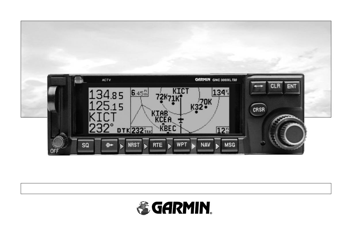
Key and Knob Functions
B
The power/volume knob controls unit power and radio volume.
Q
The squelch button activates automatic squelch control.
D
The direct-to key performs an instant direct-to, allows you to enter a
waypoint, and sets a direct course to the destination. See Section 5.
T
The nearest key is used to obtain information on the 9 nearest airports,
VORs, NDBs, intersections, user waypoints and 2 nearest FSS/ARTCC
points of communication. The nearest key also accesses any active SUA
information. See Section 4 for more information on the nearest waypoints.
R
The route key
enables you to create, edit, activate and invert routes, and
access approaches, SIDs and STARs. Search-and-rescue, parallel offset and
closest point of approach functions are also performed using the route key.
See Section 5 for more route information on routes and Section 6 for more
information on approaches, SIDs and STARs.
W
The waypoint key is used to view information such as runways, frequen-
cies, position and comments on airports, VORs, NDBs, intersections and
user waypoints. See Section 3 for more waypoint information.
N
The navigation key is used to view navigation and position information.
Planning operations are also performed using this key. See Section 1
for more information on navigation and planning operations.
vii
INTRODUCTION
Key and Knob
Functions
The GNC 300XL is designed to minimize
keystrokes when performing operations. There are
typically several ways to perform the same opera-
tion. In general, using the knobs will decrease key-
strokes and time spent using the GNC 300XL.
Experiment to find the most effective way to use
the GNC 300XL to your advantage.
300xl manual 1/25/99 2:35 PM Page vii
M
The message key is used to view system messages and to alert you to
important warnings and requirements. This key is also used to access the
GNC 300XL’s unit settings. See Section 7 for more information on messages
and unit settings.
@
The transfer key flip-flops the active and standby frequencies.
\
The clear key is used to erase information or cancel an entry.
E
The enter key is used to approve an operation or complete data entry.
It is also used to confirm information, such as during power on.
C
The cursor key is used to activate or deactivate the cursor in the separate
areas of the GNC 300XL. Pressing once will activate the cursor in the
comm ‘window’ and enable the pilot to change frequencies. Pressing twice
will activate the cursor in the GPS window (indicated by highlighted
characters in a GPS window field). It is used to highlight fields for data
entry, changing information or cycling through available options. Pressing a
third time will deactivate the cursor.
O
The outer knob is used to advance through pages, advance the cursor
or move through data fields.
K
The inner knob is used to change data or scroll through information that
cannot fit on the screen all at once.
viii
This manual will describe entering data using
the K and O knobs. Experiment with them and
become efficient in entering data with the concen-
tric knobs. This will greatly reduce the amount of
time required to navigate with the GNC 300XL.
Whenever the GNC 300XL is displaying a list
of information that is too long for the display
screen, the scrolling arrow prompt will indicate
which direction to scroll to view additional infor-
mation. To scroll through a list (with the cursor
active), simply rotate the inner knob. When the
cursor in not active, use the outer knob to view
additional information.
INTRODUCTION
Key and Knob
Functions
300xl manual 1/25/99 2:35 PM Page viii
The GARMIN GNC 300XL is a powerful navigational tool that provides pilots with accurate
navigational data and communication capability, along with along with non-precision approach
certification in the IFR environment. The Takeoff Tour is designed to familiarize you with the
operation of the GNC 300XL, including powering up the unit, changing frequencies, entering
data and performing a simple direct-to, and provide a limited introduction to the ‘Nearest’ func-
tions. In addition, this section also briefly covers the position, CDI, map and frequency pages
available from the NAV key. These pages will be used for most of your in-flight navigation.
The Takeoff Tour assumes that the GPSCOM
TM
and antennas have been properly
installed and you have not changed any of the GNC 300XL’s default settings. If you have
changed any of the factory default settings (position format, units of measure, selectable
fields, etc.), the pictures shown here may not match your configuration. Prior to using your
GNC 300XL for the first time, we recommend that you taxi to a location that is well away
from buildings and other aircraft so the unit can collect satellite data without interruption.
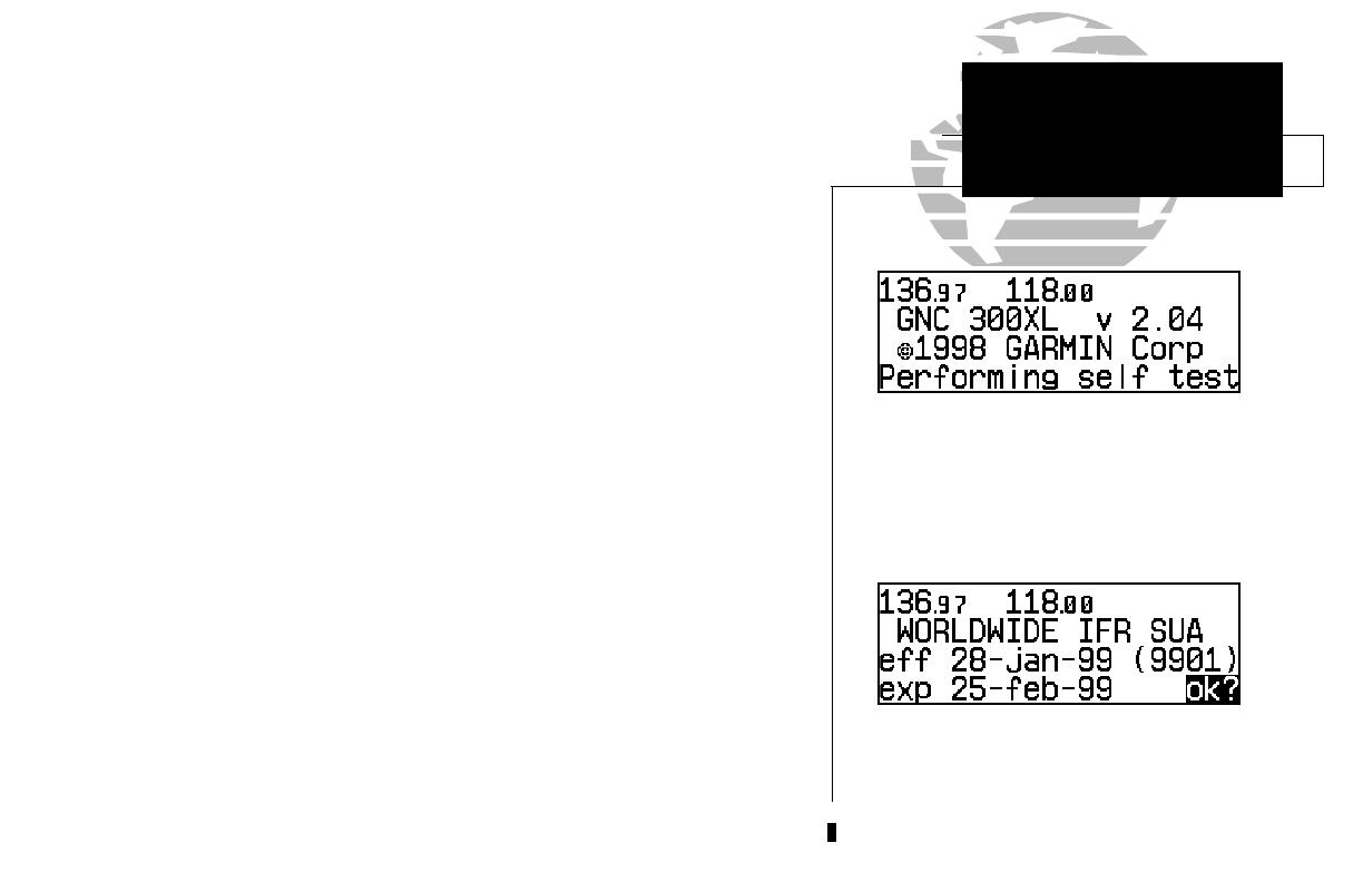
Powering up the GNC 300XL
The GNC 300XL’s power and volume are controlled using the
B
(power/volume)
knob at the bottom left of the unit. Rotating it clockwise will turn unit power on and
increase the radio volume. After turning the unit on, a welcome page will be displayed
while the unit performs a self test.
The database page will appear next, showing the current database information on the
NavData card, with the valid operating dates, cycle number and database type indicated. The
database is updated every 28 days, and must be current for approved approach and IFR opera-
tions. Information on database subscriptions is available inside your GNC 300XL package.
To acknowledge the database information:
1. Press the
E key
.
1
The database confirmation page shows the
effective and expiration dates of the Jeppesen
database on the NavData Card.
The welcome page appears when the GNC 300XL
is turned on. During the time this screen is
displayed, the GNC 300XL performs a self test to
ensure proper operation.
TAKEOFF TOUR
Power On
300xl manual 1/25/99 2:35 PM Page 1
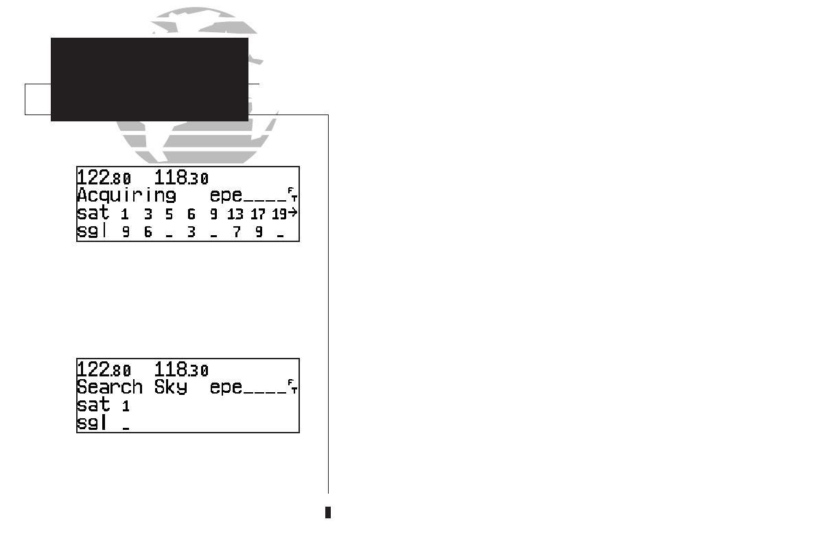
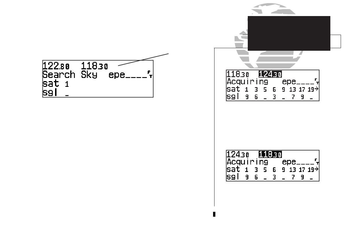
The satellite status page shows the ID numbers for
the satellites and the relative signal strength of
each satellite received. Turn the K knob to view
additional satellites.
TAKEOFF TOUR
Acquiring Satellites
‘Search Sky’ indicates that satellite almanac data
is not available or has expired (if the unit hasn’t
been used for six months or more). The data will
be recollected from the first available satellite.
Once the database has been acknowledged, the satellite status page will appear,
and the GNC 300XL will begin to collect satellite information. An ‘Acquiring’ status
will be displayed on the satellite status page, and the signal values on the bottom line
of the page will begin displaying numeric values. This is a good indication that you
are receiving signals and satellite lock will occur. Following the first-time use of your
GNC 300XL, the time required for a position fix will vary — usually from one to two
minutes.
If the unit can only obtain enough satellites for 2D navigation (no altitude), the
unit will use the altitude provided by your altitude encoder (if one is connected and
working). If not, you will be prompted to enter the altitude with a ‘Need alt- Press
NAV’ message. If this message occurs, press the
N
key and use the
K
and
O
knobs to enter the altitude shown on your altimeter. Press
E
when finished.
If the GNC 300XL has not been operated for a period of six months or more, it
may have to ‘Search the Sky’ to collect new data. This means the unit is acquiring
satellite data to establish almanac and satellite orbit information, which can take 5 to
10 minutes. The satellite status page will display a ‘Search Sky’ status, and the
message annunciator (
U
), next to the
M
key, will also flash to alert you of a system
message — ‘Searching the Sky’.
To view a system message
:
1. Press
M
.
The message page will appear and display the status or warning information
applicable to the receiver’s current operating condition.
To return to the previous page after viewing a message
:
1. Press
M
again.
2
300xl manual 1/25/99 2:35 PM Page 2
While the GNC 300XL is acquiring a position, let’s take a minute to dial in the
active and standby frequencies you’ll be using for the first phase of your flight. The
GNC 300XL’s display can be broken down into two separate ‘windows’ (or screen
areas), the comm window (the top line of the display) and the GPS window (the
bottom three lines of the display).
The
C
key is used to activate the cursor in a particular window (see right) to
provide access to various comm and navigation features. To select the active frequency,
you must first enter the frequency in the standby field, and use the
@
key to move it
to the active field.
To change the standby communication frequency:
1. Press
C
once to activate the cursor in the comm window.
2. Rotate the outer knob (
O
) to select the MHz, and the inner knob (
K
) to select the kHz of
the desired frequency.
To place the standby frequency in the active field, press
@
.
Once you’ve entered the active frequency, simply repeat steps 1 and 2 to enter the
standby frequency. After both frequencies have been entered, you may elect to keep
the comm window ‘hot’ by leaving the cursor on the standby frequency, or remove the
cursor by pressing the
C
key twice.
3
Status page with cursor active in comm window.
TAKEOFF TOUR
Selecting Comm Frequencies
Comm Window
GPS Window
Standby
Active
}
{
{
}
To switch the active and standby frequencies, press
the @ key. Switching the active and standby
frequencies will not remove the cursor from the
comm window.
300xl manual 1/25/99 2:35 PM Page 3
The map page combines a moving map display
and navigation data for complete situational
awareness.
TAKEOFF TOUR
Position Page
The navigation communications (NAVCOM) page
provides a complete list of airport frequencies at
your departure and arrival airports.
After the GNC 300XL acquires satellites and computes a position, the position page will
appear automatically, and you’ll be informed with ‘Ready for navigation’ on the message page.
The position page displays your present latitude and longitude, altitude and a reference way-
point field. The altitude and reference waypoint fields are also selectable (see Section 1 for more
information) to allow you to configure the unit to your own preferences. The default settings are:
• Altitude— Your present GPS altitude
• Present Position— Latitude and longitude displayed in degrees/minutes
• Reference Waypoint— The bearing and distance to the nearest airport
The position page is one of seven pages available under the GNC 300XL’s
N
key:
• CDI page • Map page
• NAVCOM page • Position page
• Satellite status page • NAV menu 1
• NAV menu 2
During most flights, the position, CDI (course deviation indicator), map and NAVCOM pages
will be the primary pages used for navigation. These pages are accessible by pressing the
N
key and rotating the outer knob, or by pressing the
N
key repeatedly.
4
Altitude, MSA or ESA
Position (lat/lon)
Reference Waypoint Field
{
300xl manual 1/25/99 2:35 PM Page 4
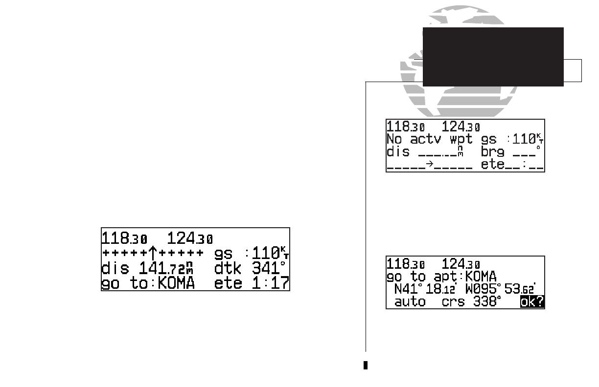
The GNC 300XL uses direct point-to-point navigation to guide you from takeoff
to touchdown in the IFR environment. Once a destination is selected, the unit will
provide speed, course and distance data based upon a direct course from your present
position to your destination. A destination can be selected from any page with the
D
(direct-to) key.
To select a direct-to destination:
1. Press the
D
key. The CDI page will appear with the destination field highlighted.
2. Rotate the
K
knob to enter the first letter of the destination waypoint identifier. The des-
tination waypoint may be an airport, VOR, NDB, intersection or user waypoint, as long as
it is in the database or stored in memory as a user waypoint.
3. Rotate the
O
knob to the right to move the cursor to the next character position.
4. Repeat steps 2 and 3 to spell out the rest of the waypoint identifier.
5. Press
E
to confirm the identifier. The direct-to confirmation page will appear.
6. Press
E
to confirm the destination.
Once the direct-to destination is confirmed, the CDI page will appear with the
destination indicated in the lower left hand corner of the screen. Your present speed
and track over the ground, and the distance and estimated time en route to your des-
tination are also displayed. The graphical CDI (course deviation indicator), located at
the top left of the screen, displays your position relative to the desired course and
provides turn anticipation and waypoint messages during route navigation.
5
When a destination is selected the direct-to
confirmation page appears to verify the destina-
tion you selected. The lat/long, facility name or
city may be displayed by highlighting the position
field (third display line) and rotating the K knob.
The CDI page without a direct-to destination or
active route appears blank, except for ground
speed (GS) and track (TRK) figures, if displayed.
TAKEOFF TOUR
Direct-To
Navigation
300xl manual 1/25/99 2:35 PM Page 5
CDI page with ‘trk’ and ‘eta’ displayed.
TAKEOFF TOUR
CDI & Map Pages
CDI page with ‘brg’ and ‘trk’ displayed.
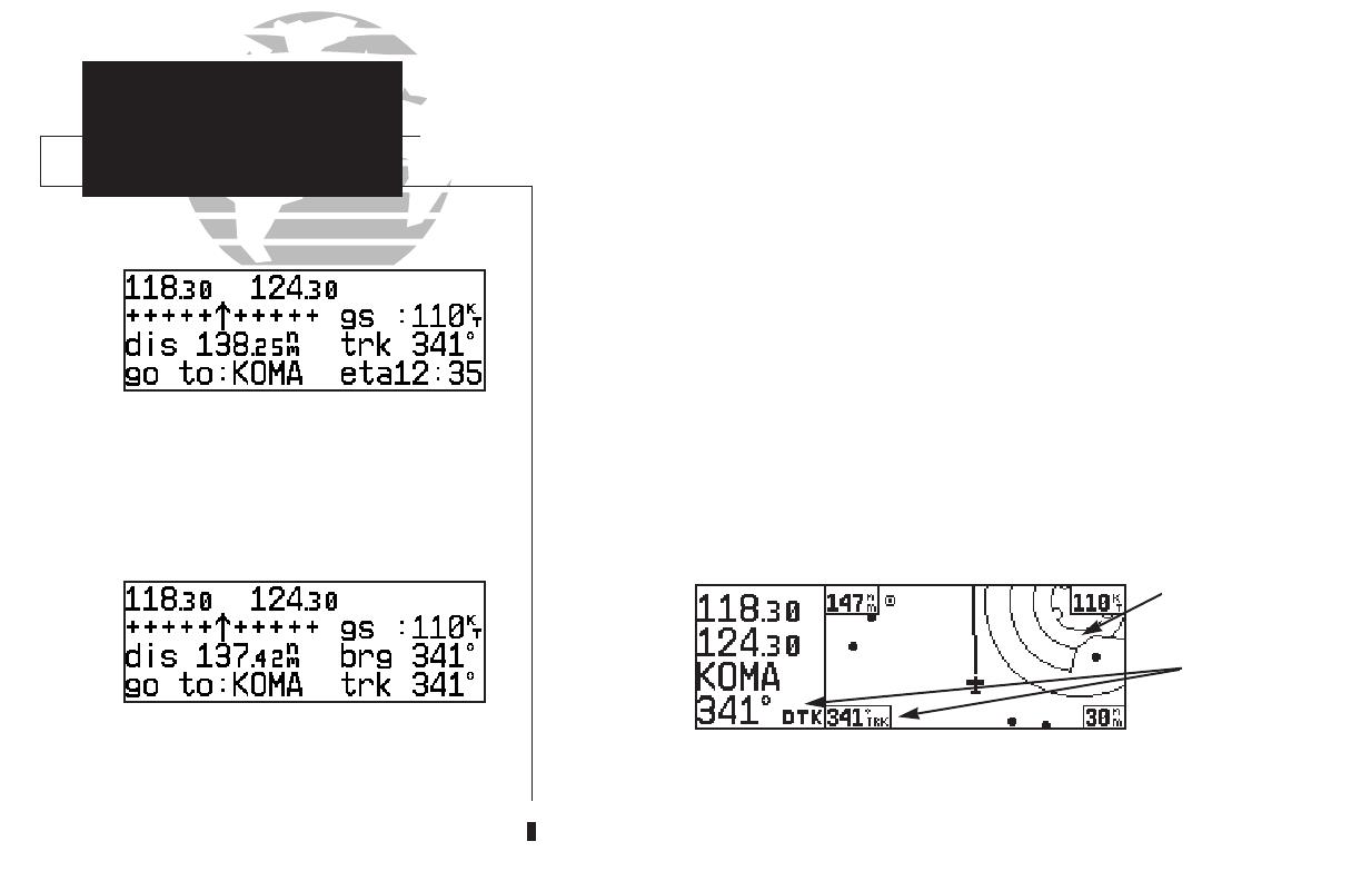
In addition to the destination field and graphical CDI, the GNC 300XL CDI page
features four selectable fields for various navigation data so that the page may be con-
figured to your own preferences (see Section 1 for more information). The default set-
tings for the CDI page are:
• Ground Speed (gs)— Your present speed over the ground in knots
• Distance (dis)— The distance to your destination in nautical miles
• Desired Track (dtk)— The course between the ‘from’ and ‘to’ waypoints
• Estimated Time En route (ete)— The time to your destination (in hours
and minutes) based upon your present speed and course
The next page available from the
N
key is the map page. The map page com-
bines the primary navigation information from the CDI page – distance to waypoint,
ground speed, desired track and ETE – with a moving map display. The moving map
display shows your current position (using an airplane symbol or a diamond symbol)
relative to nearby airports, VORs, NDBs, intersections, user waypoints and airspace
boundaries.
The map page can be divided into three main sections:
The communication frequencies are located in the upper left corner of the page,
instead of across the top line as on other pages. The top frequency is the active fre-
quency, with the standby frequency directly below.
6
Comm
Frequencies
Data Fields
{
Map Display
300xl manual 1/25/99 2:35 PM Page 6

The map display occupies the right side of the display. Your present position is indi-
cated by a plane symbol (in track up mode) or a position diamond (in other orienta-
tion modes), with your route displayed as a solid line. Nearby airports, navaids and
user waypoints may be depicted on the map; with unique identifying symbols for
each waypoint type. Boundaries for special use and controlled airspaces can also
appear on the map display. You may select which features are shown on the map
using the map setup page (see page 101).
The data fields on the map page indicate distance to destination waypoint,
desired track, ground track, ground speed and map scale. The destination waypoint
name and desired track appear on the left side of the page, below the communication
frequencies. The other data fields are located at the corners of the map display as
shown in the illustration above, and may be removed by pressing
\
.
7
Communication frequencies are shown in the top
left corner of the map page, instead of across the
top line as shown on other GNC 300XL screens.
The map display may be oriented along your
ground track (track up), course (desired track up)
or fixed at north up. Desired track up or north up
settings show your present position with a dia-
mond symbol instead of the airplane symbol.
TAKEOFF TOUR
Map Page
Present
Position
Airspace
Boundaries
Airport Waypoint
Destination
Waypoint
Map
Scale
Ground
Speed
Track
Desired
Track
Distance to Waypoint
300xl manual 1/25/99 2:35 PM Page 7

The map display has 14 available ranges from 0.5 to 300 (nautical miles, statute miles
or kilometers) representing the vertical height of the map. The map scale is con-
trolled by the inner knob (
K
), with the current scale displayed in the lower right
corner of the page.
To select a map scale:
1. Rotate the
K
knob clockwise to increase the map scale and show a larger area.
2. Rotate the
K
knob counterclockwise to decrease the map scale and show a smaller area.
Another page available under the GNC 300XL’s
N
key is the navigation
communications (NAVCOM) page. It provides you with a complete list of airport
frequencies at your departure and arrival airports, allowing convenient selection of
frequencies you’ll need along your flight path. If you do not have an active departure
airport, the navigation communications page will display the frequencies for the
airport nearest your departure position.
To view the NAVCOM page from the map page, rotate
O
one stop to the right.
The NAVCOM page lists your departure and arrival airports on the left side of the
page, with all the database frequencies listed in a column down the right side of the
page. To scroll through the list of frequencies, simply rotate the inner knob (
K
) in
the direction of the arrow prompts at the bottom left of the page.
To place a frequency from the list in the standby field:
1. Press the
C
key twice to activate the cursor in the GPS window.
2. Use the
O
knob to select the desired frequency. Press
E
to place the frequency in
the standby field. The cursor will automatically advance to the next frequency on the list.
8
The NAVCOM page lists the frequencies for your
departure and arrival airports. To place a fre-
quency from this list on standby, highlight the
desired frequency and press E.
To change the map scale rotate the K knob clock-
wise to increase the scale or counterclockwise to
decrease the scale.
TAKEOFF TOUR
Map Scales
NAVCOM Page
300xl manual 1/25/99 2:35 PM Page 8

Once a direct-to is activated, the CDI page will provide navigation to the destina-
tion until the direct-to is cancelled or another direct-to destination is activated.
To cancel a direct-to from the CDI page:
1. Press the
C
key twice to activate the cursor in the destination field.
2. Press
\
.
3. Press
E
.
The GNC 300XL’s
T
key provides the nine nearest airports, VORs, NDBs, inter-
sections, user waypoints and any SUA (special use airspace) alerts, as well as the two
closest FSS (Flight Service Station) and center (ARTCC) frequencies for your present
position. The nearest waypoint feature is a handy safety feature that may be used to
execute a quick direct-to in case of an in-flight emergency or to review the closest facil-
ities to your present position. The nearest feature can also be used to quickly find the
contact frequency of the nearest airport and enter it in the standby field.
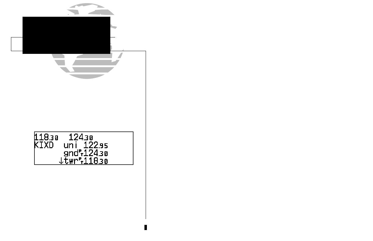
To view the nine nearest airports
:
1. Press the
T
key. The nearest airport will be displayed, with the range and bearing from
your present position, along with elevation, frequency and runway data.
2. To review the rest of the nearest airport list, rotate the
K
knob to the right.
To place a nearest airport frequency in the standby field
:
1. Press
E
. Press the
@
key to place the frequency in the active field.
To view the nearest list for other waypoint categories (VOR, NDB, etc.)
:
1. Rotate the
O
knob to the right, or press the
T
key repeatedly.
2. Rotate
K
to scroll through the list.
9
Additional frequencies may be displayed by press-
ing
C
twice and rotating the K knob (or press
\ repeatedly with the cursor inactive). To place
a nearest airport frequency in the standby field,
press E.
The nearest airport page shows up to nine
nearest airports from your present position. To
view additional nearest airports, rotate the K
knob.
TAKEOFF TOUR
Cancelling a Direct-To
Nearest Waypoints
300xl manual 1/25/99 2:35 PM Page 9
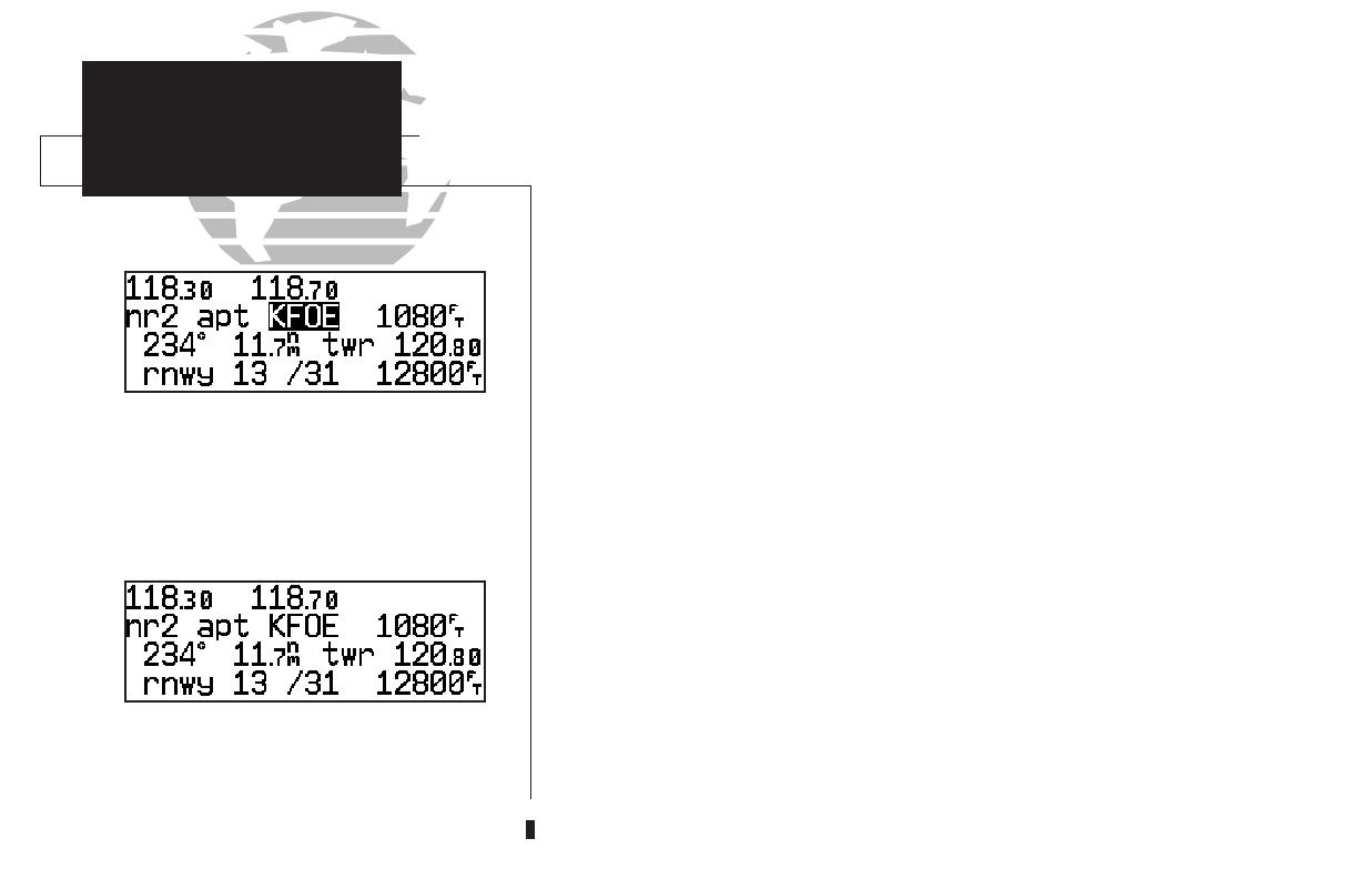
To review a nearest waypoint, highlight the identi-
fier and press E.
To select a nearest waypoint as a direct to destina-
tion, press D and E.
Once the nearest airport (or any other nearest waypoint) page is displayed, the
selected waypoint can be quickly reviewed or selected as a direct-to destination.
To review the selected waypoint from the nearest waypoint list
:
1. Press
C
twice to activate the waypoint field.
2. Press
E
to display the waypoint identification page.
3. Rotate
O
to view any additional waypoint information available.
4. Press
T
to return to the nearest waypoint page.
To select a nearest waypoint as a direct-to destination
:
1. Press the
D
key. The direct-to confirmation page for the selected waypoint will appear.
2. Press
E
to confirm.
Congratulations! You’ve covered the basic operation of the GNC 300XL. We
encourage you to experiment with your new GPSCOM to get to know all the
advanced navigation features it has to offer. If you’d like a little more practice, try
using the built-in simulator described in Appendix C. An optional AC adapter will
even let you plan and simulate flights in the comfort of your home or office.
To turn the GNC 300XL off
:
1. Turn the
B
knob to the left until the unit shuts off.
NOTE: The GNC 300XL is normally connected to power through the avionics master
switch. With the optional remote battery installed, the unit will display a power down
warning when the master switch is turned off. This warning page features a timer which
will count down from 30 seconds when the unit senses that power is off. After 30 sec-
onds, the GNC 300XL will shut off. If you wish to continue operating the unit, press
any key during the countdown period, and the unit will operate from the battery.
10
TAKEOFF TOUR
Nearest Airports
Shutting Down
300xl manual 1/25/99 2:35 PM Page 10
/