Garmin quatix Quick start guide

Category
Navigators
Type
Quick start guide

This manual is also suitable for

quatix
Quick Start Manual
April 2013 190-01594-01_0B Printed in Taiwan
quatix Quick Start Manual
WARNING
See the Important Safety and Product Information guide in the
product box for product warnings and other important
information.
Getting Started
Complete these tasks to set up the device and get to know the
basic features.
1
Charge the device (page 2).
2
Learn about profiles and sensor data (page 2).
3
Acquire satellites and record your track (page 3).
4
Mark and navigate to a waypoint (page 3).
5
Learn about applications (page 3).
6
Stream data from your NMEA 2000
®
network (page 4).
7
Register the device (page 4).
8
Get the owner's manual (page 4).
Keys
À
Select to turn the backlight on and off. Hold to turn the
device on and off.
Á
Select to scroll through the data pages, options, and
settings.
Â
Select to scroll through the data pages, options, and
settings.
Ã
Select to return to the previous screen. Hold to view the
status page.
Ä
Blue key Select to open the menu for the current screen. Select to
choose an option and to acknowledge a message. Hold
to mark a waypoint.
Charging the Device
NOTICE
To prevent corrosion, thoroughly dry the contacts and the
surrounding area before charging or connecting to a computer.
The device is powered by a built-in lithium-ion battery that you
can charge using a standard wall outlet or a USB port on your
computer.
1
Plug the USB end of the cable into the AC adapter or a
computer USB port.
2
Plug the AC adapter into a standard wall outlet.
3
Align the left side of the charging cradle
À
with the groove on
the left side of the device.
4
Align the hinged side of the charger
Á
with the contacts on
the back of the device.
When you connect the device to a power source, the device
turns on.
5
Charge the device completely.
Profiles
Profiles are a collection of settings that optimize your device
based on how you are using it. For example, the settings and
views are different when you are using the device when sailing
than when powerboating.
When you are using a profile and you change settings such as
data fields or units of measurement, the changes are saved
automatically as part of the profile.
Changing Profiles
When you change activities, you can quickly change the setup
of the device to suit the activity by changing the profile.
1
Select the blue key.
2
Select Profiles.
3
Select a profile.
The profile you selected is now the active profile. Any changes
you make are saved to the active profile.
Viewing the Data Pages
Customizable data pages allow you to quickly access real-time
data for the compass, barometer, and temperature sensors.
When you begin tracking or navigating, additional data pages
appear.
Data pages can also show data streamed from your NMEA
2000 network through a Garmin
®
GNT.
From the time of day page, select or to cycle through
the data pages.
NOTE: Sensor data is not recorded to the device.
Data Pages
By default, the time, compass, barometer, and temperature
pages appear in all data page flows. The organization and
appearance of other data pages varies based upon these
conditions.
The active profile
Whether you are tracking, navigating, or only viewing sensor
data
Whether you are streaming NMEA 2000 data through a
Garmin GNT
The data fields on each page can be customized. Some data
fields are available only when streaming NMEA 2000 data.
2
Tracking and Navigation
Acquiring Satellite Signals and Recording a Track
Before you can use the GPS navigation features, such as
recording a track, you must acquire satellite signals.
The device may need a clear view of the sky to acquire satellite
signals. The time and date are set automatically based on the
GPS position.
1
Select the blue key.
2
Select
Start GPS
.
3
Wait while the device locates satellites.
4
Travel to record a track.
Your distance and time appear.
5
Select to view the loop of data pages.
6
Hold .
7
Select an option:
Select
Pause Track
to pause tracking.
Select
Save Track
to save your track.
Select
Clear Track
to erase the track without saving.
Select
Stop GPS
to turn off GPS without deleting your
track.
Navigating to a Waypoint
1
Select the blue key.
2
Select Start GPS.
3
Wait while the device locates satellites.
4
Select the blue key.
5
Select Waypoints, and select a waypoint from the list.
6
Select
Go
.
The device displays time to destination
À
, distance to
destination
Á
, and estimated time of arrival
Â
.
7
Select to view the compass page.
The two pointer marks
Ã
serve as a bearing pointer. The top
blue mark
Ä
points in the direction you are facing.
8
Align the pointer marks with the top blue mark.
9
Continue to travel in that direction until you reach the
destination.
Stopping Navigation
1
Select the blue key.
2
Select Stop Nav..
Marking a Waypoint
Before you can mark your current location as a waypoint, you
must acquire satellite signals.
1
Hold the blue key.
2
Select an option:
To save the waypoint without changes, select Save.
To make changes to the waypoint, select Edit, make
changes to the waypoint, and select Save.
Applications
Viewing Tide Information
You can view information about a tide station, including the tide
height and when the next high and low tides will occur.
1
Select the blue key.
2
Select Tides
> Search Near
.
3
Select an option:
To search near a previously saved waypoint, select
Waypoints, and select or search for a waypoint.
To search near a specific city, select Cities, and select or
search for a city.
A list of the tide stations near the selected location appears.
4
Select a station.
A 24-hour tide chart appears for the current date, showing
the current tide height
À
and when the next high
Á
and low
tides
Â
will occur.
5
Select an option:
To view more detailed information about the next four tide
peaks and troughs, select .
To pan the tide chart, select the blue key, and select Pan
Chart.
To view tide information for a different date, select the
blue key, select Change Date, and select the date.
Tack Assist
Before you start a race, you can set the optimal tack angle for
your boat. During the race, the device indicates whether your
boat is being headed or lifted based on the tack angle you set.
1
Select the blue key.
2
Select Tack Assist > Full Cal..
Sail Racing
Before you can use the race timer to start a race, you must
select the sailing profile and set the race timer. You can also set
a virtual start line. See the owner's manual for more information.
1
Select the blue key.
2
Select Sail Race > Race.
3
Select and to synchronize the race timer with the official
race countdown, and select the blue key to start the timer.
TIP: If necessary, after you start the timer you can select
and to add or subtract time from the race timer.
Setting the Race Timer
1
Select the blue key.
2
Select Sail Race > Setup > Race Timer.
3
Use the blue key, , and to set the time.
Autopilot
Before you can use the quatix to control an autopilot, you must
install and configure a compatible Garmin GHP autopilot
3
system and pair your quatix
with the GHC
device. For more
information, see the quatix owner's manual and the owner's
manual for your autopilot.
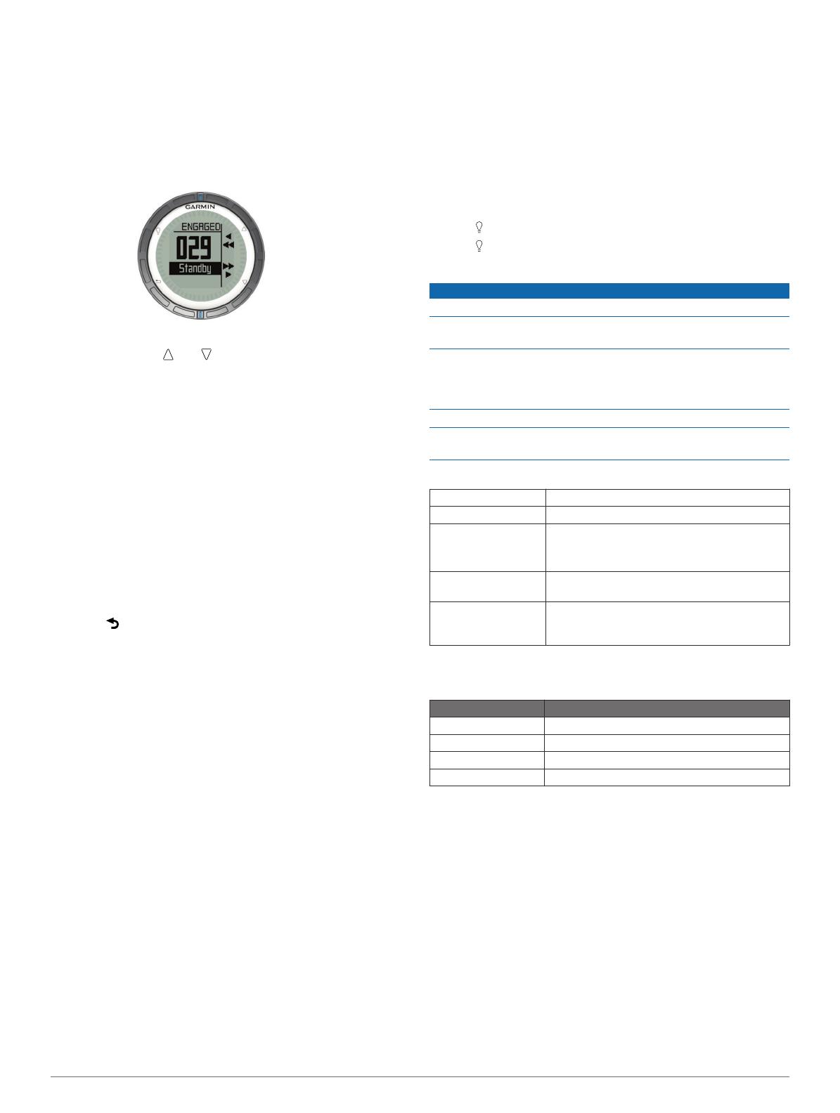
1
Select the blue key.
2
Select
Autopilot
.
3
Select an option:
To engage the autopilot heading hold, hold a steady
course, select Engage, and release the helm.
To steer the boat, engage the autopilot heading hold, and
select or hold and to steer left and right.
Select Presets, and select a button action. The map
displays a plot of the action performed by the button.
Select Disengage to take the helm.
ANT+ Sensors
Your device can be used with wireless ANT+ sensors. For more
information about compatibility and purchasing optional
sensors, go to http://buy.garmin.com.
Streaming NMEA 2000 Data
While tracking or navigating, your device can stream data from
a NMEA 2000 network equipped with a Garmin GNT.
1
Select the blue key.
2
Select Setup > ANT Sensor > GNT > On.
The data pages display information from the sensors
connected to the NMEA 2000 network. You can customize
the data fields that appear on each data page.
3
Select twice.
4
Select Stream N2K to begin streaming NMEA 2000 data.
To stop streaming NMEA 2000 data, select the blue key, and
select Stop N2K.
Using Automatic Man Overboard
If your device is connected to a Garmin GNT, you can set the
device to automatically trigger the preset man overboard
function if the device gets too far away from the GNT.
1
Select the blue key.
2
Select Auto MOB > On.
Sharing Data
Sending Data to HomePort
Before you can send data to HomePort, you must purchase
HomePort and install it on your computer (www.garmin.com
/homeport).
You can view tracks and waypoints on your computer.
1
Connect your device to your computer using the USB cable.
Your device appears as a removable drive in My Computer
on Windows
®
computers and as a mounted volume on
Mac
®
computers.
2
Start HomePort.
3
Follow the on-screen instructions.
Sending Data to BlueChart
®
Mobile
Before you can share data with the BlueChart Mobile
application, you must install it on your mobile device
(www.garmin.com/bluechartmobile).
You can view tracks and waypoints on your mobile device.
1
On your
quatix
, select the blue key.
2
Select Share Data > BlueChart Mob..
3
Start
BlueChart
Mobile on your mobile device.
4
Follow the on-screen instructions.
See the BlueChart Mobile help for more information.
Troubleshooting
Resetting Your Device
If the device stops responding, you may need to reset it.
1
Hold for at least 25 seconds.
2
Hold for one second to turn on the device.
Device Care
NOTICE
Do not use a sharp object to clean the device.
Avoid chemical cleaners, solvents, and insect repellents that
can damage plastic components and finishes.
Thoroughly rinse the device with fresh water after exposure to
chlorine, salt water, sunscreen, cosmetics, alcohol, or other
harsh chemicals. Prolonged exposure to these substances can
damage the case.
Avoid pressing the keys under water.
Avoid extreme shock and harsh treatment, because it can
degrade the life of the product.
Specifications
Battery type 500 mAh Lithium-ion battery
Battery life Up to 6 weeks
Water resistance
Water resistant to 164 ft. (50 m)
NOTE: The watch is designed for surface
swimming.
Operating
temperature range
From -4ºF to 122ºF (from -20ºC to 50ºC)
Radio frequency/
protocol
2.4 GHz ANT+ wireless communications
protocol
Bluetooth
®
Smart device
Battery Information
The actual battery life depends on how much you use GPS,
device sensors, optional wireless sensors, and the backlight.
Battery Life Mode
16 hours Normal GPS mode
25 hours NMEA 2000 streaming, GPS off
Up to 2 weeks Always On
sensor mode
Up to 6 weeks Watch mode
Registering Your Device
Help us better support you by completing our online registration
today.
Go to http://my.garmin.com.
Keep the original sales receipt, or a photocopy, in a safe
place.
Getting the Owner's Manual
You can get the latest owner's manual from the web.
1
Go to www.garmin.com/support.
2
Select
Manuals
.
3
Follow the on-screen instructions to select your product.
Getting More Information
You can find more information about this product on the Garmin
website.
Go to www.garmin.com/marine.
Go to www.garmin.com/learningcenter.
4
Go to http://buy.garmin.com, or contact your
Garmin
dealer
for information about optional accessories and replacement
parts.
5
www.garmin.com/support
913-397-8200
1-800-800-1020
0808 238 0000
+44 870 850 1242
1-866-429-9296 +43 (0) 820 220 230
+32 2 672 52 54 +45 4810 5050 +358 9 6937 9758 + 331 55 69 33 99
+49 (0)180 6 427646 + 39 02 36 699699
0800 - 023 3937
035 - 539 3727
+ 47 815 69 555
00800 4412 454
+44 2380 662 915
+ 35 1214 447 460 + 34 93 275 44 97 + 46 7744 52020
Garmin International, Inc.
1200 East 151st Street
Olathe, Kansas 66062, USA
Garmin (Europe) Ltd.
Liberty House, Hounsdown Business Park
Southampton, Hampshire, SO40 9LR UK
Garmin Corporation
No. 68, Zhangshu 2nd Road, Xizhi Dist.
New Taipei City, 221, Taiwan (R.O.C.)
Garmin
®
and the Garmin logo are trademarks of Garmin Ltd.
or its subsidiaries, registered in the USA and other countries.
ANT+
, HomePort, BlueChart
®
Mobile, quatix, GHC,
GHP, and GNTand are trademarks of Garmin Ltd. or its
subsidiaries. These trademarks may not be used without the
express permission of Garmin.
The Bluetooth
®
word mark and logos are owned by the
Bluetooth SIG, Inc. and any use of such marks by Garmin is
under license. Mac
®
is a registered trademark of Apple
Computer, Inc. Windows
®
is a registered trademark of
Microsoft Corporation in the United States and other countries.
Other trademarks and trade names are those of their
respective owners.
© 2013 Garmin Ltd. or its subsidiaries
1 / 1

Garmin quatix Quick start guide

Category
Navigators
Type
Quick start guide
This manual is also suitable for

Ask a question and I''ll find the answer in the document

Finding information in a document is now easier with AI

Ask the document