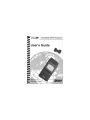
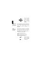
II Morrow Inc. GPS Receiver 920 GPS User manual
- Category
- GPS receiver modules
- Type
- User manual


History of Revisions
October 1993 Original Release
October 1993 Revision 01
December 1993 Revision 02
June 1994 Revision 03
December 1994 Revision 04
Ordering Information
This manual covers software version 3.0 or greater.
To receive additional copies of this publication, order part
#560-0101-04, Apollo Handheld GPS Receiver User’s Guide.
II Morrow is a trademark of II Morrow Inc.
The Apollo logo is a registered trademark of II Morrow Inc.
No part of this document may be reproduced in any form or
by any means without the express written consent of
II Morrow Inc.
© 1994 by II Morrow Inc. All rights reserved.
Printed in the U.S.A.
II Morrow Inc. 2345 Turner Road S.E.
P.O. Box 13549 Salem, OR 97302
Salem, OR 97309 U.S.A.
Phone (503) 581-8101
1-800-525-6726
In Canada 1-800-654-3415
FAX (503) 364-2138
http://www.iimorrow.com
II MORROW
VISIONARY THINKING TODAY

Important Notice
The Apollo handheld GPS receiver is intended for use as a
navigation aid. In aviation applications, the receiver should
be used to complement certified navigation instruments
already installed in the aircraft. This device is not
intended for use as a primary or sole source of
navigation information in aviation applications. Never
fly the aircraft without other available means of navigation.
For maximum safety and to minimize distraction in the
cockpit, place the receiver in an easily visible location,
within convenient view of other avionics.
This device emits a small amount of electromagnetic
energy. Do not place the receiver closer than 190mm
(approx. 7.5") to the wet compass in the cockpit.
Due to implementation of Selective Availability by the
United States Department of Defense, all GPS receivers
may suffer degradation of position accuracy by as much as
100 meters.
The following guidance has been issued by the FAA,
Seattle Aircraft Certification Office and Seattle Aircraft
Evaluation Group on December 12, 1994. It is relevant
to the use of portable GPS navigation systems in
aircraft:
The information contained in FAA Flight
Standards Notice No. 8310.171, dated October
19, 1992, is still applicable.

The use of portable GPS receivers in aircraft falls
under FAR 91.21 for Portable Electronic Devices
for operations conducted under FAR part 91
Operating Rules Only. It is the responsibility of
the aircraft operator to ensure that the device does
not interfere with other systems in the aircraft.
The GPS system must not be used for primary
navigation and can only be used for comparison
purposes during flight(s).
Official Notifications to the User
U.S.
This device complies with Part 15 of the F.C.C. Rules.
Operation is subject to the following two conditions:
(1) this device may not cause harmful interference, and
(2) this device must accept any interference received,
including interference that may cause undesired operation.
Canada
This digital apparatus does not exceed the Class B limits
for radio noise emissions from digital apparatus as set out
in the Radio Interference Regulations of the Canadian
Department of Communications.
Le présent appareil numérique n’émet pas de bruits
radioélectriques depassant les limites applicables aux
appareils numériques de classe B prescrites dans le
reglement sur le brouillage radioelectrique public par le
ministère des communications du Canada.

Germany
It is hereby certified that the Model 920 GPS handheld has
been suppressed in accordance with the provisions for the
BMPT-AmtsblVfg 243/1991. The correct operation of some
equipment (for example, test transmitters) in accordance
with the regulations may be subject to certain restrictions.
Please refer to the notes in the operating instructions.
The Bundesamt für Zulassungen in Der Telekommunikation
has been notified of the placing on the market of this
equipment and the right has been granted to test the series for
compliance with the regulations.
Hiermet wird bescheinigt, daß das Model 920 GPS handheld
in Übereinstimmung mit den Bestimmungen der
BMPT-AmtsblVfg 243/1991 funkenstört ist. Der
vorschriftsmäßige Betrieb mancher Geräte (z. B. Meßsender)
kann allerdings gewissen Einschränkungen unterllegen.
Beachen Sie deshalb die Hinweise in der Bedienungsanleiung.
Dem Bundesamt für Zulassungen in Der
Telekommunikation wurde das Inverkenhrbringan dieses
Gerätes angezeigt und die Berechtigung zur Überprüfung
der Serie auf Einhaltung der Bestimmungen eingeräumt.

Table of Contents
Page
Section A - Introduction to Satellite Navigation . A-1
What is GPS? . . . . . . . . . . . . . . . . . . . . . . . . . . A-1
What Does the GPS Receiver Do?. . . . . . . . . . A-1
How Does GPS Work?. . . . . . . . . . . . . . . . . . . A-1
Section B - Getting Started . . . . . . . . . . . . . . . . . . B-1
Switching the GPS Receiver On and Off. . . . . B-1
Switching the Display Backlight On and Off. . B-2
The Function Keys . . . . . . . . . . . . . . . . . . . . . . B-2
The MENU/PWR Key. . . . . . . . . . . . . . . . . B-2
The NEW WPT Key . . . . . . . . . . . . . . . . . . B-3
The INFO Key. . . . . . . . . . . . . . . . . . . . . . . B-3
The GOTO/NRST Key . . . . . . . . . . . . . . . . B-3
The ARROW Keys . . . . . . . . . . . . . . . . . . . B-4
The ENTER Key . . . . . . . . . . . . . . . . . . . . . B-4
Calling the Navigation Screens . . . . . . . . . . . . B-4
Helpful Instructions on the Display . . . . . . . . . B-5
Entering a Seed Position. . . . . . . . . . . . . . . . . . B-6
Entering a Destination Waypoint . . . . . . . . . . . B-8
Searching for Nearest Waypoints. . . . . . . . . . . B-9
Navigating to a Destination . . . . . . . . . . . . . . B-10
The Navigation Screens . . . . . . . . . . . . . . . . . B-10
Numeric Navigation Screens. . . . . . . . . . . B-11
Moving Map Screens. . . . . . . . . . . . . . . . . B-13
i

Zooming In or Out. . . . . . . . . . . . . . . . . . . B-14
Auto Zoom. . . . . . . . . . . . . . . . . . . . . . . . . B-16
Orthographic Navigation Screen . . . . . . . . . . B-17
Other Screens . . . . . . . . . . . . . . . . . . . . . . . . . B-17
Creating Waypoints . . . . . . . . . . . . . . . . . . . . B-18
Entering Present Position as a Waypoint. . B-18
Creating User Waypoints. . . . . . . . . . . . . . B-19
Using the Navigation Simulator. . . . . . . . . . . B-20
Section C - The Waypoint Database. . . . . . . . . . . C-1
Available Waypoint Information . . . . . . . . . . . C-2
ARPT Waypoint Information . . . . . . . . . . . C-2
VOR Waypoint Information . . . . . . . . . . . . C-2
NDB Waypoint Information . . . . . . . . . . . . C-3
INT Waypoint Information . . . . . . . . . . . . . C-3
CITY Waypoint Information. . . . . . . . . . . . C-3
USER Waypoint Information . . . . . . . . . . . C-3
Viewing Waypoint Information . . . . . . . . . . . . C-4
“GOTO” Waypoint Information . . . . . . . . . C-4
Nearest Waypoint Information . . . . . . . . . . C-5
Scanning Waypoints for Information . . . . . C-6
Section D - Advanced Features. . . . . . . . . . . . . . . D-1
The Main Menu . . . . . . . . . . . . . . . . . . . . . . . . D-1
Calling the Main Menu . . . . . . . . . . . . . . . . . . D-1
Main Menu Options . . . . . . . . . . . . . . . . . . . . . D-2
Return to Nav . . . . . . . . . . . . . . . . . . . . . . . D-3
Operation Mode. . . . . . . . . . . . . . . . . . . . . . D-3
ii

Time and Place . . . . . . . . . . . . . . . . . . . . . . D-4
Screen and Beeper. . . . . . . . . . . . . . . . . . . . D-5
Map Setups . . . . . . . . . . . . . . . . . . . . . . . . . D-6
Declutter Maps . . . . . . . . . . . . . . . . . . . . . . D-7
Track Point History . . . . . . . . . . . . . . . . . . . D-8
Arrival Alerts. . . . . . . . . . . . . . . . . . . . . . . D-10
Airspace Alerts . . . . . . . . . . . . . . . . . . . . . D-10
CDI Scale. . . . . . . . . . . . . . . . . . . . . . . . . . D-12
Parallel Track. . . . . . . . . . . . . . . . . . . . . . . D-13
Magnetic Var. . . . . . . . . . . . . . . . . . . . . . . D-14
Countdown Time. . . . . . . . . . . . . . . . . . . . D-15
Display Units. . . . . . . . . . . . . . . . . . . . . . . D-15
Serial Outputs . . . . . . . . . . . . . . . . . . . . . . D-16
Battery Check . . . . . . . . . . . . . . . . . . . . . . D-18
User Waypoint Management. . . . . . . . . . . D-19
System Information. . . . . . . . . . . . . . . . . . D-21
Setting Up Multiple Leg Trips. . . . . . . . . . . . D-21
The Route Screen . . . . . . . . . . . . . . . . . . . D-21
Creating a Route . . . . . . . . . . . . . . . . . . . . D-22
Changing a Route Waypoint . . . . . . . . . . . D-23
Adding a Route Waypoint. . . . . . . . . . . . . D-24
Deleting Route Waypoints . . . . . . . . . . . . D-25
Starting a Route. . . . . . . . . . . . . . . . . . . . . D-26
Stopping or Holding a Route. . . . . . . . . . . D-26
Resuming a Route . . . . . . . . . . . . . . . . . . . D-27
Route “Direct To” . . . . . . . . . . . . . . . . . . . D-28
iii

Entering GPS Approaches . . . . . . . . . . . . . . . D-29
GPS Overlay Approaches . . . . . . . . . . . . . D-29
Approach Waypoint Identifiers. . . . . . . . . D-29
Runway Centerline Extensions . . . . . . . . . D-31
Runway Centerline Waypoint Identifiers . D-32
Inserting Approaches Into Routes. . . . . . . D-32
Checking Satellite Signal Strength. . . . . . . . . D-35
Managing Messages. . . . . . . . . . . . . . . . . . . . D-36
Airspace Alert Message. . . . . . . . . . . . . . . D-37
Arrival Alert Message . . . . . . . . . . . . . . . . D-37
Low Battery Alert Message. . . . . . . . . . . . D-38
No Position Alert Message . . . . . . . . . . . . D-38
Parallel Track Alert Message . . . . . . . . . . D-39
Course Deviation Alert Message. . . . . . . . D-39
Current Messages. . . . . . . . . . . . . . . . . . . . . . D-40
External Electrical Connections. . . . . . . . . . . D-40
Section E - Differential GPS Operation . . . . . . . . E-1
What is Differential GPS? . . . . . . . . . . . . . . . . E-1
How Does Differential GPS Work? . . . . . . . . . E-1
Using Differential GPS. . . . . . . . . . . . . . . . . . . E-2
Where is Differential GPS Data Available?. . . E-2
Section F - Care of the GPS Receiver . . . . . . . . . . F-1
Replacing the Batteries. . . . . . . . . . . . . . . . . . . F-1
Cleaning the GPS Receiver. . . . . . . . . . . . . . . . F-2
Section G - Glossary of Navigation Terms. . . . . . G-1
iv

Section H - Index . . . . . . . . . . . . . . . . . . . . . . . . . . H-1
Specifications . . . . . . . . . . . . . . . . . . . . . . Back Cover
V

Notes:

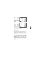
Section A - Introduction to Satellite Navigation
What
is GPS?
The Global Positioning System (GPS) is a
constellation of 24 satellites in six orbit lanes
10,898nm above the earth. Each satellite orbits
the earth twice in 24 hours.
What
Does the
GPS
Receiver
Do?
The Apollo handheld GPS receiver is a
portable position sensor and computer which
receives signals from the GPS satellites to
provide highly accurate position information.
With an extensive database of waypoint
information and the ability to allow the user to
create up to 2,000 “customized” waypoints, the
Apollo handheld GPS receiver gives you the
ability to navigate to any point in the world
with unsurpassed accuracy.
How Does
GPS
Work?
GPS satellites transmit complex streams of data
the GPS receiver uses to find the satellite’s
position, the current time, and other
information. With signals from three or more
satellites, the receiver can calculate latitude and
longitude; with four or more satellites, altitude
can also be calculated. For optimal access to
satellite signals, the GPS antenna should have
an unobstructed view of the entire sky. The
internal antenna is located in the top portion of
the Apollo handheld GPS receiver.
A
1

Depending on the relative position of the
satellites to one another, their elevation above
the horizon, and other factors, the accuracy of
the position fix can change. Under ideal
conditions, the position can be accurate to
within 10 meters. In general, a GPS receiver
position fix is accurate to within 100 meters.
GPS altitude is based on a mathematical
model of the sphere of the earth. Including
intentional degradation introduced by
Selective Availability, GPS altitude may differ
from barometric altitude by several hundred
feet.
Unlike land-based position sensors, a GPS
receiver can provide an accurate position fix
over land, sea, or in the air anywhere in the
world. Also, position accuracy of the GPS
receiver is unaffected by atmospheric conditions.
Intended for use in aviation, marine, and general
terrestrial applications, the Apollo handheld GPS
receiver is an advanced navigation device built
with quality and pride. We at II Morrow Inc. are
certain you will find it to be a versatile and
valuable travel companion.
A
2

Section B - Getting Started
This section explains how to get started using
the Apollo handheld GPS receiver.
Information in this section explains how to:
understand the keys on the keypad
enter a destination waypoint
navigate to a destination
save your present position in memory
create user waypoints
use the navigation simulator
The Apollo handheld GPS receiver is easy to
use. Install the batteries included or connect
the receiver to an external power source. Then,
spend a few minutes to read the instructions in
this section and you will be on your way to
navigating with precise accuracy.
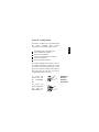
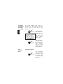
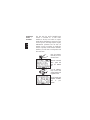
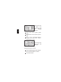
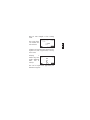
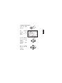
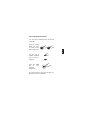
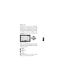
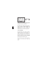
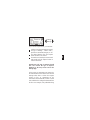
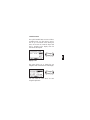
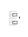
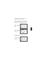
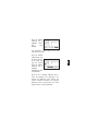
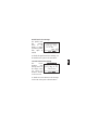
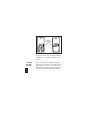
Switching
the GPS
Receiver
On and Off
To switch the
receiver on, press
the MENU/PWR
key.
To switch the
receiver off, press
and hold the
MENU/PWR key.
B
1

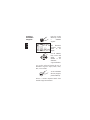
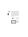
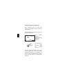
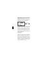
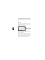
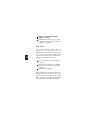
Switching
the Display
Backlight
On and Off
The Apollo handheld GPS receiver is
equipped with a display backlight, allowing
you to view the display in low light
conditions.
Press the MENU/
PWR key to access
the main menu. A
symbol in the
upper right of the
screen indicates
battery capacity.
Press the MENU/
PWR key several
times to switch the
display backlight
from off to low
intensity, then high
intensity, then off.
The
Function
Keys
The MENU/PWR Key
Use the MENU/
PWR key to switch
the receiver on and
off, and to access
to the main menu
of options at
anytime.
B
2

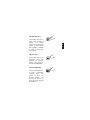
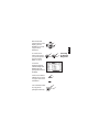
The NEW WPT Key
Use the NEW WPT key to
create a new waypoint at
anytime. The created
waypoint can be the present
position or enter latitude
and longitude coordinates
to create a “customized”
user waypoint.
The INFO Key
Use the INFO key to view
information about any
waypoint in memory,
whether user created or
from the included database.
The GOTO/NRST Key
Use the GOTO/NRST key
to assign a destination
waypoint, either user
created or from the
included database. You
can also use this key to
select the nearest waypoint
as a destination.
B
3

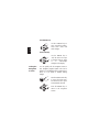
The ARROW Keys
Use the ARROW keys to
move around the display,
select menu items, and
make changes.
The ENTER Key
Use the ENTER key to
“tell” the receiver to accept
a selection from any menu
or to acknowledge
messages on the display.
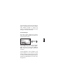
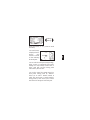
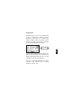
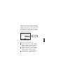
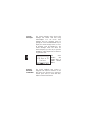
Calling the
Navigation
Screens
You can quickly call the navigation screens to
view navigation progress anytime. This can be
helpful if you accidentally select an option from a
menu, or if you decide to abandon making
changes.
Press the MENU/ PWR key
to access the main menu.
The “Return to Nav” option
is automatically selected.
Press the ENTER key to
return to the navigation
screens.
B
4

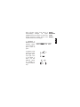
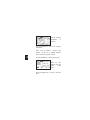
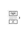
Helpful
Instructions
on the
Display
When selecting options from menus or
acknowledging messages, the Apollo
handheld GPS receiver shows you what to do.
Helpful instructions typically appear on the
top and bottom lines of the display.
A highlighted, or
darkened word in an
instruction advises
you of which key to
press to select an
option.
An up/down or left/
right arrow symbol
may appear at the
lower right corner
of the display to
advise you that
additional options
are available by
using the ARROW
keys.
B
5

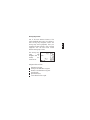
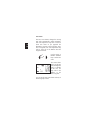
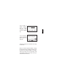
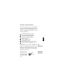
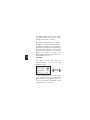
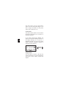
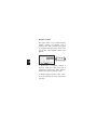
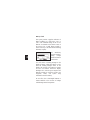
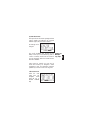
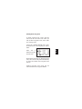
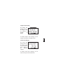
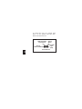
Entering a
Seed
Position
The first time the Apollo handheld GPS
receiver is switched on, it must locate
satellites in the sky from which to acquire
signals before determining a position fix. This
is a slow process, involving complex, lengthy
mathematical operations and can take 30
minutes or more to complete. To enable the
receiver to quickly locate and track available
satellites, you must enter a seed position and
the current time.
Press the MENU/
PWR key to access
the main menu.
Select the “Time and
Place” option and
press the ENTER
key.
Use the ARROW
keys to select and
change latitude and
longitude values.
Set the latitude and
longitude coordinates
near to your
position.
B
6

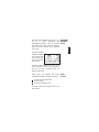
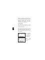
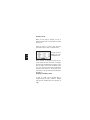
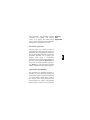
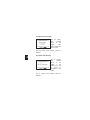
It is not necessary to enter minutes or
hundredths of a minute values.
Set the date. Use
the ARROW keys
to select and set
the current month,
day and year.
Set the time. Use
the ARROW keys
to select and set
local time.
Set the difference
between local time
and UTC time.
Deduct one hour
UTC differential for
daylight saving time.
For example, if UTC time is noon and it is
7:00 A.M. the same day in your time zone, the
UTC time differential would be +05.00.
Press the ENTER
key to enter the time
and place and return
to the main menu.
B
7
Page is loading ...
Page is loading ...
Page is loading ...
Page is loading ...
Page is loading ...
Page is loading ...
Page is loading ...
Page is loading ...
Page is loading ...
Page is loading ...
Page is loading ...
Page is loading ...
Page is loading ...
Page is loading ...
Page is loading ...
Page is loading ...
Page is loading ...
Page is loading ...
Page is loading ...
Page is loading ...
Page is loading ...
Page is loading ...
Page is loading ...
Page is loading ...
Page is loading ...
Page is loading ...
Page is loading ...
Page is loading ...
Page is loading ...
Page is loading ...
Page is loading ...
Page is loading ...
Page is loading ...
Page is loading ...
Page is loading ...
Page is loading ...
Page is loading ...
Page is loading ...
Page is loading ...
Page is loading ...
Page is loading ...
Page is loading ...
Page is loading ...
Page is loading ...
Page is loading ...
Page is loading ...
Page is loading ...
Page is loading ...
Page is loading ...
Page is loading ...
Page is loading ...
Page is loading ...
Page is loading ...
Page is loading ...
Page is loading ...
Page is loading ...
Page is loading ...
Page is loading ...
Page is loading ...
Page is loading ...
Page is loading ...
Page is loading ...
Page is loading ...
Page is loading ...
Page is loading ...
Page is loading ...
Page is loading ...
Page is loading ...
Page is loading ...
Page is loading ...
Page is loading ...
Page is loading ...
Page is loading ...
Page is loading ...
Page is loading ...
Page is loading ...
Page is loading ...
Page is loading ...
Page is loading ...
Page is loading ...
Page is loading ...
Page is loading ...
Page is loading ...
Page is loading ...
Page is loading ...
-
 1
1
-
 2
2
-
 3
3
-
 4
4
-
 5
5
-
 6
6
-
 7
7
-
 8
8
-
 9
9
-
 10
10
-
 11
11
-
 12
12
-
 13
13
-
 14
14
-
 15
15
-
 16
16
-
 17
17
-
 18
18
-
 19
19
-
 20
20
-
 21
21
-
 22
22
-
 23
23
-
 24
24
-
 25
25
-
 26
26
-
 27
27
-
 28
28
-
 29
29
-
 30
30
-
 31
31
-
 32
32
-
 33
33
-
 34
34
-
 35
35
-
 36
36
-
 37
37
-
 38
38
-
 39
39
-
 40
40
-
 41
41
-
 42
42
-
 43
43
-
 44
44
-
 45
45
-
 46
46
-
 47
47
-
 48
48
-
 49
49
-
 50
50
-
 51
51
-
 52
52
-
 53
53
-
 54
54
-
 55
55
-
 56
56
-
 57
57
-
 58
58
-
 59
59
-
 60
60
-
 61
61
-
 62
62
-
 63
63
-
 64
64
-
 65
65
-
 66
66
-
 67
67
-
 68
68
-
 69
69
-
 70
70
-
 71
71
-
 72
72
-
 73
73
-
 74
74
-
 75
75
-
 76
76
-
 77
77
-
 78
78
-
 79
79
-
 80
80
-
 81
81
-
 82
82
-
 83
83
-
 84
84
-
 85
85
-
 86
86
-
 87
87
-
 88
88
-
 89
89
-
 90
90
-
 91
91
-
 92
92
-
 93
93
-
 94
94
-
 95
95
-
 96
96
-
 97
97
-
 98
98
-
 99
99
-
 100
100
-
 101
101
-
 102
102
-
 103
103
-
 104
104
-
 105
105


II Morrow Inc. GPS Receiver 920 GPS User manual
- Category
- GPS receiver modules
- Type
- User manual
Ask a question and I''ll find the answer in the document
Finding information in a document is now easier with AI
Related papers

Other documents
-
Apollo Apollo 360 MAP User manual
-
Garmin GPS 95AVD User guide
-
-
-
-
-
-
-
-