
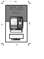
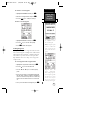
GPS 125
Sounder
Marine
Navigator
ZOOM
Owner’s Manual
&
Reference
125 Man Rev B 7/23/98 11:47 AM Page i

Software Version 2.0 or above
© 1997 GARMIN Corporation
1200 E. 151st Street, Olathe, KS USA 66062
Tel: 913-397-8200 or 800-800-1020
Fax: 913-397-8282
Web Site Address: www.garmin.com
GARMIN (Europe) Ltd.
Unit 5, The Quadrangle, Abbey Park, Romsey, SO51 9AQ, U.K.
Tel: 011-44-1794-519944
Fax: 011-44-1794-519222
GARMIN (Taiwan) Corp.
4th Fl., No. 1., Lane 45,
Pao-Hsing Road,
Hsin Tien, Taiwan R.O.C.
Phone: 886.02.917.3773
Fax: 886.02.917.1758
All rights reserved. No part of this manual may be reproduced or transmitted in any
form or by any means, electronic or manual, including photocopying and recording, for
any purpose without the express written permission of GARMIN.
Information in this document is subject to change without notice. GARMIN reserves
the right to change or improve its products and to make changes in the content without
obligation to notify any person or organization of such changes or improvements.
GARMIN, AutoLocate, and TracBack are all trademarks of GARMIN Corporation
and may not be used without the expressed permission of GARMIN.
July 1997 Part #190-00111-00 Rev. B Printed in Taiwan.
125 Man Rev B 7/23/98 11:47 AM Page ii

i
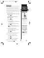
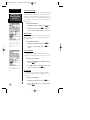
INTRODUCTION
Overview
GPS 125
SOUNDER
Operator’s
Manual
Welcome to the easiest-to-use combination GPS/Depth Sounder on the
water! The GPS 125 Sounder represents GARMIN’s continuing commitment to
provide mariners with quality navigation and fishfinding information in a versa-
tile, accurate, and user-friendly design which will be useful for years to come. It
is important that you take the time to read through the operator’s manual to
understand the operating features of the GPS 125 Sounder. The manual is orga-
nized into four sections for your convenience:
Introduction gives a quick overview of the manual and contains the table
of contents and glossary of navigation terms.
Getting Started takes you through step-by-step instructions to initialize the
receiver for first-time use and introduces you to the basic features of the unit
with a quick-start orientation to the GPS 125 Sounder. This section has been
designed to acquaint you with the unit and provide a basic working knowledge
necessary to use the unit in typical conditions.
Reference provides detailed explanations of the advanced features and oper-
ations of the GPS 125 Sounder in a topical format. This allows you to concen-
trate on a specific topic quickly, without reading through entire sections of text
that you may not need.
The Appendix section contains installation instructions and items with mul-
tiple listings, such as: map datums, time offsets, and the index.
See your GARMIN dealer for accessories including our PC kit and standard
or temperature reading in-hull and transom-mount transducers.
Thanks for choosing the GARMIN GPS 125 Sounder. We hope it will help
you meet all of your navigation and fishfinding needs.
125 Man Rev B 7/23/98 11:47 AM Page iii

Caution
INTRODUCTION
ii
The GPS system is operated by the government of the United States,
which is solely responsible for its accuracy and maintenance. The system is
subject to changes which could affect the accuracy and performance of all
GPS equipment. Although the GPS 125 Sounder is a precision electronic
NAVigation AID (NAVAID), any NAVAID can be misused or misinterpreted
and, therefore, become unsafe.
Use the GPS 125 Sounder at your own risk. To reduce the risk of
unsafe operation, carefully review and understand all aspects of this
Operator’s Manual and thoroughly practice operation using the simulator
mode prior to actual use. When in actual use, carefully compare indications
from the GPS 125 Sounder to all available navigation sources including the
information from other NAVAIDs, visual sightings, maps, etc. For safety,
always resolve any discrepancies before continuing navigation.
NOTE: This device meets requirements for Part 15 of the FCC limits for
Class B digital devices for home or office use. It has been tested for compli-
ance with all necessary FCC standards. This equipment generates, uses, and
can radiate radio frequency energy and, if not installed and used in accor-
dance with the instructions, may cause harmful interference to radio commu-
nications. However, there is no guarantee that interference will not occur in a
particular installation. If this equipment does cause harmful interference to
other equipment, which can be determined by turning the equipment off and
on, the user is encouraged to try and correct the interference by relocating the
equipment or connecting the equipment to a different circuit than the affected
equipment. Consult an authorized dealer or other qualified service technician
for additional help if these remedies do not correct the problem. Operation is
subject to the following conditions: (1) This device cannot cause harmful
interference, and (2) this device must accept any interference received,
including interference that may cause undesired operation. The GPS 125
Sounder does not contain any user-serviceable parts. Repairs should only be
made by an authorized service center. Unauthorized repairs or modifications
could void your warranty and your authority to operate this device under Part
15 regulations.
125 Man Rev B 7/23/98 11:47 AM Page iv

1
INTRODUCTION
Table of
Contents
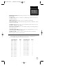
SECTION ONE Introduction
Glossary/Navigation Basics . . . . . . . . . . . . . . . . . . . . . . . . . . . . . . . .2-4
SECTION TWO Getting Started
Turning On and Initializing the Receiver . . . . . . . . . . . . . . . . . . . . . .5-7
Primary Page Overview . . . . . . . . . . . . . . . . . . . . . . . . . . . . . . . . . .8-9
Marking a Waypoint . . . . . . . . . . . . . . . . . . . . . . . . . . . . . . . . . . . . .10
Position Page and Map Basics . . . . . . . . . . . . . . . . . . . . . . . . . . . .11-12
Going to A Waypoint . . . . . . . . . . . . . . . . . . . . . . . . . . . . . . . . . . . . .12
Using the Highway Page and Cancelling a GOTO . . . . . . . . . . . . .13-14
Using The Sounder Page . . . . . . . . . . . . . . . . . . . . . . . . . . . . . . . .14-17
Clearing a Map and Turning Off . . . . . . . . . . . . . . . . . . . . . . . . . . . . .17
SECTION THREE Reference
Satellite Page . . . . . . . . . . . . . . . . . . . . . . . . . . . . . . . . . . . . . . . .17-19
Position Page . . . . . . . . . . . . . . . . . . . . . . . . . . . . . . . . . . . . . . . . . . .20
Marking, Saving, and Using Waypoints . . . . . . . . . . . . . . . . . . . . .21-28
TracBack Navigation . . . . . . . . . . . . . . . . . . . . . . . . . . . . . . . . . . .29-30
Creating and Using Routes . . . . . . . . . . . . . . . . . . . . . . . . . . . . . .31-36
Sounder Page . . . . . . . . . . . . . . . . . . . . . . . . . . . . . . . . . . . . . . . .37-40
Map Plotting, Zooming, and Cursor Movement . . . . . . . . . . . . . . .41-43
Using the Compass and Highway Navigation Pages . . . . . . . . . . . .44-46
Menu Page and Distance/Sun Calculation . . . . . . . . . . . . . . . . . . . . . .47
Track Log Setup . . . . . . . . . . . . . . . . . . . . . . . . . . . . . . . . . . . . . .47-48
Interface Setup and DGPS Interface . . . . . . . . . . . . . . . . . . . . . . . .49-51
System Setup . . . . . . . . . . . . . . . . . . . . . . . . . . . . . . . . . . . . . . . .51-52
Navigation Setup . . . . . . . . . . . . . . . . . . . . . . . . . . . . . . . . . . . . .53-55
Map Page Setup . . . . . . . . . . . . . . . . . . . . . . . . . . . . . . . . . . . . . .55-56
Alarms Setup . . . . . . . . . . . . . . . . . . . . . . . . . . . . . . . . . . . . . . . . . .57
Sounder Setup . . . . . . . . . . . . . . . . . . . . . . . . . . . . . . . . . . . . . . .58-61
Navigation Simulator . . . . . . . . . . . . . . . . . . . . . . . . . . . . . . . . . .62-63
Appendix A––Installation . . . . . . . . . . . . . . . . . . . . . . . . . . . . . . .64-69
Appendix B—Wiring and Specifications . . . . . . . . . . . . . . . . . . . .70-71
Appendix C—Messages and Time Offsets . . . . . . . . . . . . . . . . . . .72-73
Appendix D—Map Datums . . . . . . . . . . . . . . . . . . . . . . . . . . . . .74-76
Appendix E––Index . . . . . . . . . . . . . . . . . . . . . . . . . . . . . . . . . . .77-78
125 Man Rev B 7/23/98 11:47 AM Page 1

Glossary
INTRODUCTION
2
The GPS 125 Sounder is a powerful navigation tool that can guide you any-
where in the world. To better understand its operation and capabilities, it may be
helpful to review the basic terms and concepts briefly explained below.
Other navigation and GPS definitions used in the manual are defined in the
appropriate reference sections of the manual.
Almanac Data
Satellite constellation information (including location and health of satellites) that is
transmitted to your receiver from every GPS satellite. Almanac data must be acquired
before GPS navigation can begin.
Bearing (BRG)
The compass direction from your position to a destination.
Course Made Good (CMG)
The bearing from the “active from” position (your starting point) to your present
position.
Crosstrack Error (XTE)
The distance you are off a desired course in either direction.
Desired Track (DTK)
The compass course between the “from” and “to” waypoints.
Differential GPS (DGPS)
An extension of the GPS system that uses land-based radio beacons to transmit position
corrections to GPS receivers.
Estimated Time of Arrival (ETA)
The time of day of your arrival at a destination.
Estimated Time Enroute (ETE)
The time left to your destination at your present speed.
Ground Speed (SOG)
The velocity you are traveling relative to a ground position.
125 Man Rev B 7/23/98 11:47 AM Page 2

3
INTRODUCTION
Glossary
Latitude
The north/south measurement of position perpendicular to the earth’s polar axis.
Longitude
An east/west measurement of position in relation to the Prime Meridian, an imagi-
nary circle that passes through the north and south poles.
Position
An exact, unique location based on a geographic coordinate system.
Sensitivity
A measure of how sensitive the sounder is to sonar echoes.
Speed Over Water (SOW)
The speed you are traveling over the surface of the water.
Thermocline
A layer of water separating warmer water above from cooler water below.
Track (TRK)
The direction of movement relative to a ground position.
Universal Transverse Mercator (UTM)
A grid coordinate system that projects global sections onto a flat surface to measure
position in specific zones.
Velocity Made Good (VMG)
The speed you are traveling in the direction of your destination.
Waypoint
A specific location saved in the receiver’s memory.
Whiteline
A term applied to the checkered portion of the sonar display which shows the area
of strongest sonar return (typically the bottom).
125 Man Rev B 7/23/98 11:47 AM Page 3

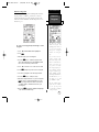
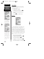
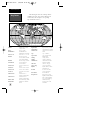
Navigation
Basics
INTRODUCTION
4
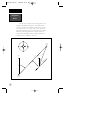
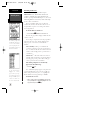
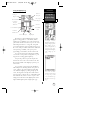
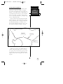
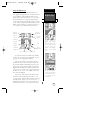
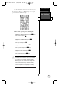
NORTH
“ACTIVE FROM”
WAYPOINT
NORTH
DTK
CROSSTRACK ERROR
BRG
TRK
GROUND SPEED
DISTANCE
“ACTIVE TO”
WAYPOINT
“ACTIVE LEG”
The GPS 125 Sounder provides steering guidance and
navigation information using degrees, a measurement mea-
sured in a clockwise direction from a north reference. North
is described as 000º, east as 090º, south as 180º, and west as
270º. The diagram and compass rose below provide a graphic
illustration of the navigation terms used by the GPS 125
Sounder. More information on basic navigation and GPS are
available at your local library or bookstore.
125 Man Rev B 7/23/98 11:47 AM Page 4

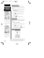
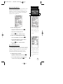
Getting Started with Your GPS
Welcome to the exciting world of GARMIN GPS!
The GPS 125 Sounder represents GARMIN’s continuing
commitment to provide marine users with quality navi-
gation information in a versatile, user-friendly design
they will enjoy for years to come. To get the most out
of your GPS receiver, be sure to read through the ini-
tialization and Getting Started sections of this manual,
and refer to the reference section for complete details
on the GPS 125 Sounder’s advanced features.
Initializing Your GPS for First-Time Use
The first time you power up your new GPS 125
Sounder is an important step in getting the best possi-
ble future GPS performance.
Because a GPS receiver can only receive signals
from satellites above the horizon, it needs to know
what satellites to look for at any given time. By using
an almanac (a timetable of satellite numbers and their
orbits) stored in the receiver’s memory, the GPS 125
Sounder can determine the distance and position of
any GPS satellite and then use this information to
determine your position.
To obtain this almanac data, your GPS receiver
needs to be initialized or given the opportunity to “find
itself”, the very first time it is turned on. Once you
have initialized the unit, the GPS 125 Sounder will
compute future fixes more rapidly, usually in a few
minutes.
Remember, that initializing the unit is only neces-
sary under the following conditions:
• First-time use from the factory
• If the receiver has been moved over 500 miles
from the last calculated position with power
off
• If the receiver’s memory has been cleared and
all stored data has been lost
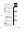
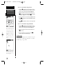
5
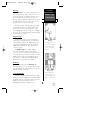
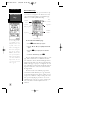
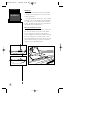
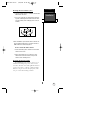
Welcome Page
The welcome page will
appear as soon as the GPS
125 Sounder is turned on
and remain on while the
unit conducts a brief
self-test.
GETTING
STARTED
Initialization
125 Man Rev B 7/23/98 11:47 AM Page 5

Initializing the Receiver
The receiver is shipped from the factory in
AutoLocate™ mode, which enables the GPS 125
Sounder to determine its location anywhere in the
world. To speed up the initialization process, we recom-
mend using EZinit described below, which will usually
provide a fix in a few minutes.
Before you initialize, make sure your GPS 125
Sounder unit, antenna, and transducer have been cor-
rectly installed on your boat according to the instruc-
tions in Appendix A.
To turn the GPS 125 Sounder on:
1. Press and hold
P
until the receiver turns on.
The welcome page will be displayed while the unit
conducts a self test.
Once testing is complete, the welcome page will be
replaced by the status page, with the EZinit prompt
ready for you to select one of two initialization
methods:
•Select Country––allows you to initialize the
receiver by selecting your present position from a
list of countries in the GPS 125 Sounder’s internal
database. This usually provides a position fix in a
few minutes.
•AutoLocate
TM
––allows the GPS 125 Sounder to
initialize itself and calculate a position fix without
knowing your present position. This usually pro-
vides a position fix in 7.5-15 minutes.
If the EZinit prompt has not automatically
appeared on the Satellite Page:
1. Press the
F
key.
Note: If the EZinit prompt appears at any time after
you have initialized the receiver (because satellite sig-
nals are being obstructed by trees, etc.), highlight ‘No
Re-Init’ with the arrow keypad and press ENTER.
To initialize the receiver:
1. If the ‘country’ option is not highlighted, press the
D
key repeatedly to move the field highlight to the ‘coun-
try’ option and press the
F
key.
Initialization
GETTING
STARTED
6
The EZinit prompt will
automatically appear if the
receiver needs to be initial-
ized. The prompt may also
appear during normal use if
the antenna is shaded.
Use the arrow keypad to
highlight the country,
region, or state of your pre-
sent position from the list
and press ENTER. If the
country is not listed, select
the closest country instead.
125 Man Rev B 7/23/98 11:47 AM Page 6

2. Use the
D
key to scroll through the list options until
the country of your present position appears.
3. Use
U
to highlight the country/state/region you’re in.
If the country you’re in is not listed, select another
country within 500 miles of your present position.
4. Press
F
to finish.
The GPS 125 Sounder will now begin searching for
the appropriate satellites for your location and should
acquire a position within a few minutes. You can verify
that you have acquired a position by watching the
Satellite Page transition to the Position Page (provided
you haven’t pressed any other buttons) or by looking for
a ‘2D NAV’ or ‘3D NAV’ status at the top left corner of
the Satellite Page.
Initialization Troubleshooting
If you have trouble initializing the receiver or
acquiring a position, check the following:
• Does the antenna have a clear view of the sky?
If there are nearby buildings, heavy tree cover, a
covered boat slip, etc., the unit may not be receiving
enough satellite signals to calculate a position.
• Have you selected the right country/state/region
from the EZinit list?
Check for the correct approximate lat/long on the
Position Page or reselect the appropriate country
from the list to restart the initialization.
• Have you moved more than 500 miles from the
last calculated position with the receiver off?
Reinitialize the receiver, selecting the country/state/
region of your new location from the EZinit list.
Your unit should now be initialized. If you want to
complete the Getting Started Tour at another time, you
may now turn the GPS 125 Sounder off (see below) or
you may continue.
To turn the GPS 125 Sounder off:
1. Press and hold
P
for approximately three seconds
until the receiver turns off.
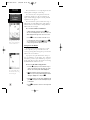
7
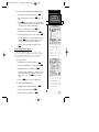
The GPS 125 Sounder’s
Satellite Page will help you
determine which satellites
are in view and whether or
not any satellites are being
“shaded” or blocked from
the receiver’s antenna.
By monitoring the signal
strength bars at the bottom
of the page and the sky view,
you’ll be able to see how
moving to another area with
a clearer view of the sky will
improve satellite reception
and speed up signal
acquisition.
GETTING
STARTED
Initialization
125 Man Rev B 7/23/98 11:47 AM Page 7

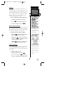
Sounder Page
Primary Pages
The GPS 125 Sounder uses six primary “pages” to
give you information. The pages are arranged in a con-
tinual loop and can be easily viewed in forward or
reverse order by pressing either the
J
or
Q
key.
Before we start the tour, let’s briefly look at these pages.
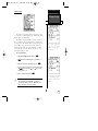
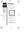
Satellite Page
The Satellite Page shows satellite positions and
signal strength. Satellite positions are shown using a
“birds-eye-view” display. Signal strength bars are shown
for each satellite in use. Satellite status and estimated
position error (EPE) are shown in the upper corners.
Position Page
The Position Page shows you where you are, what
direction you’re heading and how fast you’re going. The
top of the page contains a compass tape which is a
graphic representation of your heading. Your track and
speed are indicated immediately below, with the digital
depth displayed at the bottom of the page.
The graphic compass tape reflects your head-
ing only while you are moving.
The rest of the page shows your current position in
three dimensions: latitude, longitude and altitude. A
trip odometer and 12/24-hour clock are also provided.
Sounder Page
The Sounder Page gives a view of the water
beneath your boat while displaying sonar contacts and
bottom contour.
Primary Pages
GETTING
STARTED
8
Satellite Page
The Satellite Page will
allow you to monitor
satellite signal reception
and strength.
!
#
J
Q
125 Man Rev B 7/23/98 11:47 AM Page 8

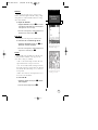
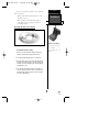
Map Page
The Map Page acts as a window that allows you to
view your position, the “path” you have traveled over,
and nearby waypoints. A diamond icon in the center of
the screen represents your present position. As you
move, you will see a thin line, called a track log, appear
along the path you have just covered. Names of stored
waypoints can also be shown on the map.
The bottom corners of the page will always display
your current track and speed, with the digital depth
shown in the center. If you are navigating to a way-
point, highlighting an on-screen waypoint, or panning
the cursor, the corresponding distance and bearing will
be shown at the top corners.
Navigation Page
A navigation page gives you directional guidance
when going to a waypoint. The GPS 125 Sounder has
two navigation page choices: the Highway Page or the
Compass Page. The Highway Page is the default and
will be briefly explained here. The Compass Page is
covered on pg. 46.
The Highway Page uses a graphic highway to
show your movement in relation to your desired
course. The upper section shows bearing and distance
to the waypoint and your current track and speed. The
middle portion contains the actual highway. The bot-
tom of the page contains the estimated time enroute
(ETE) and your velocity made good (VMG).
Menu Page
The last primary page is the Menu Page. The
Menu Page gives you access to the GPS 125 Sounder’s
waypoint management, route, track log, and setup fea-
tures through a list of submenus.
Screen Backlighting
The GPS 125 Sounder features three levels of back-
lighting. Activate the backlight by pressing the POWER
key briefly. Each press of the button advances the back-
lighting to the next level and then turns it off.
Backlighting will remain on until turned off.
9
Map Page
The Map Page shows your
progress on a moving map
plotter and gives a bird’s-
eye-view of surrounding
waypoints.
GETTING
STARTED
Primary Pages
& Backlighting
Highway Page
With the Highway Page,
you will get graphic steer-
ing guidance in navigating
a route or to a single way-
point.
125 Man Rev B 7/23/98 11:47 AM Page 9

Getting Started Tour
Now that your GPS receiver has been initialized and
you are familiar with the primary pages, it’s time to take
a tour. This is a live tour and is to be conducted with
your unit installed and with the boat in the water. The
tour will take you through the receiver’s basic features
and functions as you move about on the water and
assumes that the GPS 125 Sounder is turned on, initial-
ized, and that you have not changed any of the factory
settings (units of measure, selectable fields, etc.). If
these settings have been changed, the pictures and
descriptions in this manual may not match what you
see on your screen.
Navigation Simulator
If you are not able to take the Getting Started tour
with your boat in the water, you may use the built-in
navigation simulator to practice using the GPS 125
Sounder. To use the simulator, see pg. 60.
Marking a Waypoint
To begin the live tour, let’s take the position you
have acquired (either by just initializing the unit or by
having turning the unit on) and mark it as a waypoint.
1. Press the
M
key to capture and hold your position.
To mark a position, you must have a 2D or 3D
fix, or have the receiver in simulator mode. If
you try to mark a position without a position fix,
a ‘No GPS Position’ message will be displayed.
The mark position page will appear, showing the
captured position and a default 3-digit waypoint name.
Let’s change the name something more meaningful, like
‘DOCK’.
1. Press the
D
key once to move the field highlight
from the ‘SAVE?’ field to the name field.
2. Press
F
to clear the default name.
3. Press and hold the
U
key to scroll through the alpha-
bet until the letter ‘D’ appears.
Marking A
Waypoint
GETTING
STARTED
10
To save a waypoint with the
default three-digit name,
simply press the MARK key
followed by the ENTER key.
The GPS 125 Sounder will
then return to the page pre-
viously displayed.
Press the UP arrow to move
forward through the alpha-
bet or numbers and DOWN
to move backward.
!
#
125 Man Rev B 7/23/98 11:47 AM Page 10

4. Press the
R
key once to move the character highlight
to the next character space.
5. Repeat steps 3 and 4 until the word ‘DOCK’ is shown.
6. Press
F
to complete entry of the name.
7. Press the
D
key twice to return the field highlight
to the ‘SAVE?’ field.
8. Press the
F
key to confirm that you want to save
the position as a waypoint named ‘DOCK’.
The mark position page will now be replaced by
the Position Page (or whatever page was displayed
prior to pressing the
M
key). The ‘DOCK’ waypoint
is now stored in the GPS 125 Sounder’s memory, and
will remain there until you manually remove it or clear
the receiver’s memory. For more on waypoint manage-
ment, see pg. 21-28.
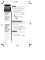
Using the Position and Map Pages
Now that you’ve marked a position, let’s see how
the Position and Map Pages can be used to monitor
your progress as we head out into the open water.
As always, ensure your primary focus is on
boating traffic and monitor the GPS 125
Sounder briefly when operating your boat.
The direction you are moving (track) and your
speed are shown on the top of the Position Page, below
the graphic compass tape. The latitude, longitude, and
approximate altitude of your position--with a resettable
trip odometer--are displayed in the middle of the page,
with the time of day and digital depth shown below.
11
The arrow keypad is used
for all data entry. Use the
UP and DOWN keys to
select letters, numbers, or
menu options, and use the
LEFT and RIGHT keys to
move the cursor forward or
backward along the line.
GETTING
STARTED
Marking
Waypoint &
Map Page
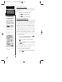
The Map Page displays
your present position as a
diamond icon and provides
a real-time graphic “bread-
crumb” display of your
track right on the screen.
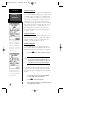
Altitude
Current Speed
Track Over
Ground
Graphic
Compass Tape
Tr i p
Odometer
Position
Display
12/24 Hour
Time
Digital Depth
!
#
125 Man Rev B 7/23/98 11:47 AM Page 11

Using the Position and Map Pages (continued)
Now let’s change the display to the Map Page and
watch the track log of our tour:
1. Press
J
to change from the Position Page to the
Map Page.
Your current position is shown as the diamond in
the middle of the screen. The dark circle below the dia-
mond represents the position you created, with the line
between the two showing your track.
1. Once you have reached an area that allows for gener-
al changes in direction without interfering in the pas-
sage of other boats, mark your current position again
and name this waypoint “CHANNL”. (See ‘Marking a
Waypoint’ on pg. 10-11).
2. Next, make a moderate turn in any direction safe for
navigation and proceed for another 3 minutes.
Going To a Waypoint
Once you’ve stored the ‘CHANNL’ waypoint in
memory, you can use the GPS 125 Sounder to guide
you to it by performing a simple GOTO. A GOTO is
simply the receiver drawing a straight-line course from
your present position to the destination you’ve selected.
Use caution when navigating. A “straight-line”
course reflects the shortest distance to a way-
point, and does not navigate around obstruc-
tions, such as land or buoys, etc.
Now that you have moved away from ‘CHANNL’ for
three minutes, let’s try navigating back to it.
To select a GOTO destination:
1. Press the
G
key. The GOTO waypoint page will
appear, displaying all the waypoints in memory in
alphabetical order.
2. Use
U
or
D
to highlight the ‘CHANNL’ waypoint.
3. Press the
F
key to confirm that you want to navi-
gate to the displayed waypoint. The Highway Page
(default) will appear.
Position/Map
Pages and
GOTO
GETTING
STARTED
12
The moving map’s default
screen orientation is track
up orientation. “Track up”
means that your current
direction of travel is always
up (or towards the top of)
the screen. It can also be set
for north up, or desired
track orientation through
the map setup page.
The GOTO waypoint page
allows you to select a desti-
nation from a list of all
available waypoints in the
GPS 125 Sounder’s
memory.
!
#
125 Man Rev B 7/23/98 11:47 AM Page 12

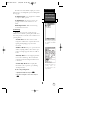
Using the Highway Page
The GPS 125 Sounder’s Highway Page provides
graphic steering guidance to a destination, with an
emphasis on a straight-line course to the desired way-
point and the distance and direction you are off course.
The bearing and distance to a waypoint, along with
your current track and speed are displayed at the top of
the screen, with your estimated time enroute (ETE) and
velocity made good (VMG), or the speed you are
approaching your destination, shown at the bottom.
As you head toward your destination, the middle
section of the screen provides visual guidance to your
waypoint on a moving graphic “highway”.
Your present position is represented by the dia-
mond in the center of the course deviation scale. The
line down the middle of the highway represents your
desired track.
As you navigate toward a waypoint, the highway
will actually move, indicating the direction you’re off
course, relative to the position diamond on the CDI
scale. When the highway is pointing straight up the
screen, the waypoint is directly ahead. If the destina-
tion waypoint is to the left, the top of the highway will
lead toward the left, and vice versa. To stay on course
simply steer in the direction the highway leads (left or
right) until the highway leads straight up the page.
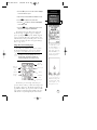
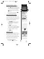
13
A waypoint is directly
ahead when the highway is
pointing straight up. In the
above example, the way-
point is to the right (111º) of
our present course (100º).
Turn right until the highway
points straight up the
screen.
GETTING
STARTED
Using the
Highway Page
Once you are one minute
from the destination (based
on your present speed and
course), an arrival message
will appear on the message
page.
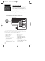
Bearing to
Waypoint
Destination
Waypoint
“Finish Line”
CDI Scale
Distance to
Waypoint
Destination Waypoint
Digital Depth
Velocity Made
Good
Current Speed
Current Track
Estimated
Time Enroute
Position Diamond
Pointer to Waypoint
125 Man Rev B 7/23/98 11:47 AM Page 13

Using the Highway Page (continued)
While navigating, you may use the Compass Page
(see picture below left) instead of the Highway Page.
To select the Compass Page:
1. While viewing the Highway Page press
F
twice.
The Compass Page will now become the displayed
navigation page. This page provides a directional point-
er to your destination by using a compass display to
show direction of travel. This provides better steering
guidance at slower speeds for travel with many direc-
tional changes.
To return to the Highway Page, press ENTER twice.
Cancelling a GOTO
If you decide to stop navigating to the active way-
point waypoint, all you have to do is cancel the GOTO.
To cancel an active GOTO:
1. Press the
G
key.
2. Use the arrow keypad to move the field highlight to the
‘CANCEL GOTO?’ prompt at the bottom of the page and
press
F
.
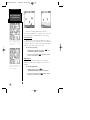
Using the Sounder Page
Now that you have learned the basics of GPS
Navigation, let’s briefly look at how the GPS 125
Sounder works for you as a fishfinder. The fishfinding
features are covered in detail on pg. 37-40.
The top of the Sounder Page shows the range mode
being used, the water temperature (if using a tempera-
ture-sensitive transducer), and the digital depth, while
the middle of the page contains a right-to-left moving
sonar image of the water beneath your boat. (Note:
items appear as they pass under your transducer. Those
objects appearing on the right side of the screen are
closer to you than those objects on the left.) Fish are
displayed as a darkened arch or a fish icon in three dif-
ferent sizes. Thermoclines (layers of water separating
warmer water above and cooler water below) appear as
dotted patterns just above the bottom.
Highway/
Sounder Page &
Cancelling GOTO
GETTING
STARTED
14
The 125 Sounder will also
provide steering guidance
with a graphic Compass
Page.
To change the display from
the Highway Page, press
ENTER twice.
Once a GOTO is activated,
the GPS 125 Sounder pro-
vides steering guidance
until the GOTO is canceled.
To cancel a GOTO, high-
light the cancel prompt at
the bottom of the page and
press ENTER.
125 Man Rev B 7/23/98 11:47 AM Page 14

Using the Sounder Page (continued)
The area of strongest sonar return (whiteline) is
displayed as light and dark checkering. Typically, the
bottom will be the primary source of the whiteline. A
thin whiteline indicates a softer bottom while a thicker
whiteline shows a harder bottom. A black line is used
to show the point where water meets the whiteline.
This black line will follow the bottom contour, along
with any significant objects lying on the bottom. Along
the left side of the screen (typically) is an adjustable
scale which shows the current display’s range of depth.
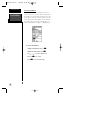
Range Modes
The GPS 125 Sounder uses two range modes: auto
and manual. ‘Auto’ displays the most information pos-
sible while continuously displaying the bottom.
‘Manual’ lets you select the displayed range. You may
switch between auto and manual modes by using the
arrow keypad or by using the sounder setup menu.
To switch from auto to manual mode:
1. Press the
U
or
D
keys until the desired depth
range is displayed on the depth scale at the left side
of the page.
2. Press
F
to confirm the selected range.
To switch from manual to auto mode:
1. Press the arrow keypad up or down until a repeated
beep sounds. ‘Auto’ will be shown in the range field at
the top left corner of the screen, and press
F
.
Underwater waypoints
The underwater waypoint feature marks a way-
point’s position and its depth. This makes it easier to
find and use an object such as a stump for a future
fishing location. For instructions on marking an under-
water waypoint, see pg. 38.
Sounder Zoom
The sounder zoom function allows you to see the
current display picture at 2 times (2X) or 4 times (4X)
magnification. 2X means that the screen displayed will
now cover 1/2 the range you were originally viewing in
twice the detail, and 4X shows 1/4 the original range at
four times the detail. Because less area is being shown
(in a zoom screen) objects can be seen in greater detail.
15
GARMIN’s exclusive See-
Thru technology will allow
you to distinguish sonar tar-
gets from bottom clutter and
thermoclines.
GETTING
STARTED
Sounder Page,
Range Modes, &
Sounder Zoom
Use the target cursor to
mark the desired underwa-
ter location.
Note: The bearing and
range shown are to the cur-
sor’s location from your pre-
sent position.
125 Man Rev B 7/23/98 11:47 AM Page 15

The zoom function is accessed by using the IN and
OUT key when viewing the Sounder Page.
Once activated, the zoomed picture becomes the
Sounder Page display. Note: The zoom function can
only be deactivated by pressing the OUT key until the
original zoom scale appears.
The zoom function operates in either Auto range or
Manual range. Zooming while in Auto will continue to
follow the bottom contour, while zooming in Manual
will show the selected depth.
To access the sounder zoom function:
1. While viewing the Sounder Page, press
I
once.
The 2X screen will appear. Note: the current zoom scale
will be displayed in the upper left corner of the screen.
2. Press
I
once more to advance to the 4X screen.
3. To deactivate the sounder zoom function, press
I
once. You may also press and hold
H
until the original
scale picture appears and a triple beep sounds.
Moving the Zoom Window
You may move the displayed range on a zoomed
screen at any time, just as you would a non-zoom
screen, by pressing the arrow keypad up or down. This
will move the zoom “window”.
If you prefer to keep the window in its new posi-
tion, you will need to save the change. Note: Saving the
new window position requires different steps if you are
in Auto range when you move the window versus being
in Manual when the window is moved.
To save a zoom window range in Auto:
1. Press the
R
keypad up to view a shallower range or
down to view a deeper range. The range scale on the
left side of the zoomed picture will be highlighted.
2. When the window reaches the desired range, press
F
to accept. A ‘Change To Manual Range?’ window
will appear. Highlight ‘Yes” and press
F
.
3. If you do not want to save the range, highlight ‘No’ and
press
F
. You may then resume manually moving the
zoom window.
4. Press
Q
at any time to return to an auto range mode
display.
Sounder Zoom
& Zoom
Window
GETTING
STARTED
16
Pressing the IN key once
while on the Sounder Page
activates the 2X Zoom.
The zoom window may be
moved at any time by using
the arrow keypad.
125 Man Rev B 7/23/98 11:47 AM Page 16
Page is loading ...
Page is loading ...
Page is loading ...
Page is loading ...
Page is loading ...
Page is loading ...
Page is loading ...
Page is loading ...
Page is loading ...
Page is loading ...
Page is loading ...
Page is loading ...
Page is loading ...
Page is loading ...
Page is loading ...
Page is loading ...
Page is loading ...
Page is loading ...
Page is loading ...
Page is loading ...
Page is loading ...
Page is loading ...
Page is loading ...
Page is loading ...
Page is loading ...
Page is loading ...
Page is loading ...
Page is loading ...
Page is loading ...
Page is loading ...
Page is loading ...
Page is loading ...
Page is loading ...
Page is loading ...
Page is loading ...
Page is loading ...
Page is loading ...
Page is loading ...
Page is loading ...
Page is loading ...
Page is loading ...
Page is loading ...
Page is loading ...
Page is loading ...
Page is loading ...
Page is loading ...
Page is loading ...
Page is loading ...
Page is loading ...
Page is loading ...
Page is loading ...
Page is loading ...
Page is loading ...
Page is loading ...
Page is loading ...
Page is loading ...
Page is loading ...
Page is loading ...
Page is loading ...
Page is loading ...
Page is loading ...
Page is loading ...
Page is loading ...
Page is loading ...
-
 1
1
-
 2
2
-
 3
3
-
 4
4
-
 5
5
-
 6
6
-
 7
7
-
 8
8
-
 9
9
-
 10
10
-
 11
11
-
 12
12
-
 13
13
-
 14
14
-
 15
15
-
 16
16
-
 17
17
-
 18
18
-
 19
19
-
 20
20
-
 21
21
-
 22
22
-
 23
23
-
 24
24
-
 25
25
-
 26
26
-
 27
27
-
 28
28
-
 29
29
-
 30
30
-
 31
31
-
 32
32
-
 33
33
-
 34
34
-
 35
35
-
 36
36
-
 37
37
-
 38
38
-
 39
39
-
 40
40
-
 41
41
-
 42
42
-
 43
43
-
 44
44
-
 45
45
-
 46
46
-
 47
47
-
 48
48
-
 49
49
-
 50
50
-
 51
51
-
 52
52
-
 53
53
-
 54
54
-
 55
55
-
 56
56
-
 57
57
-
 58
58
-
 59
59
-
 60
60
-
 61
61
-
 62
62
-
 63
63
-
 64
64
-
 65
65
-
 66
66
-
 67
67
-
 68
68
-
 69
69
-
 70
70
-
 71
71
-
 72
72
-
 73
73
-
 74
74
-
 75
75
-
 76
76
-
 77
77
-
 78
78
-
 79
79
-
 80
80
-
 81
81
-
 82
82
-
 83
83
-
 84
84


Ask a question and I''ll find the answer in the document
Finding information in a document is now easier with AI
Related papers

Other documents
-
Eagle Map Guide Pro Installation And Operation Instructions Manual
-
-
 EURO-WARE 178 User manual
-
-
Lowrance ENDURA Quick start guide
-
 Whitelines 17001 User guide
-
Magellan Map 410 User manual
-
 GlobalSat GH Series User GH-561 GPS Trek Pro Quick start guide
-
-
Standard Horizon DS41bbbc Owner's manual


