Page is loading ...

DeLorme Topo North America™ 9.0 User Guide
Created June 8, 2010

WARNING: Messaging, tracking and SOS functions require an active Iridium satellite subscription.
Always test your device before you go.
This manual is provided as a convenience.
GARMIN IS NOT RESPONSIBLE FOR THE ACCURACY OF THIS MANUAL AND DISCLAIMS ANY
LIABILITY ARISING FROM THE RELIANCE THEREON.

iii
Table of Contents
Getting Started ...................................................................................................................................................... 1
Map Legend ......................................................................................................................................................... 18
Using the Toolbar ................................................................................................................................................ 23
Customizing the Map and Tab Display ................................................................................................................. 29
Using Keyboard Shortcuts .................................................................................................................................... 44
Viewing Map Data ............................................................................................................................................... 50
Using Projects and Map Files ............................................................................................................................... 51
Finding a Location on the Map ............................................................................................................................. 57
Using Address Book Contacts ............................................................................................................................... 72
Printing ................................................................................................................................................................ 78
Using the Draw Tools ........................................................................................................................................... 89
Routing .............................................................................................................................................................. 141
Using GPS .......................................................................................................................................................... 159
Using Voice Navigation ...................................................................................................................................... 177
Geocaching ........................................................................................................................................................ 186
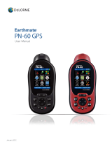
Using Earthmate PN-Series GPS Devices ............................................................................................................ 189
Using Third-party GPS Devices ........................................................................................................................... 207
Using Small-screen Devices ................................................................................................................................ 212
Profiling Linear Objects ...................................................................................................................................... 213
Viewing Your Map in 3-D ................................................................................................................................... 222
Using NetLink and MapShare ............................................................................................................................. 228
Using GeoTagger ................................................................................................................................................ 233
Legal Information .............................................................................................................................................. 236
Index.................................................................................................................................................................. 249


1
Getting Started
Welcome to DeLorme Topo North America
Helpful Links
• DeLorme—product information and more
• Technical Support—searchable knowledge base, articles, troubleshooting
• Community Forums—a wealth of information from the people who use our
products
• DeLorme Weblog—announcements, tips and tricks, and tutorials
• PN-Series Wiki—all the information about PN-Series GPS devices you need in one
place
What's New
• DeLorme Topo USA is now DeLorme Topo North America!
• Canada topographic detail—includes elevation contours, shaded relief, land cover,
highways, streets, and back roads.
• 210,000 new and updated U.S. roads, as well as 11,000 national forest trails and
Bureau of Land Management recreation lands.
• Search for DeLorme Atlas and Gazetteer™ symbols and see them on the map.
• Connect directly to Geocaching.com from Topo North America—download pocket
queries to sync with your Earthmate PN-Series GPS.
• Use Earthmate GPS Sync to sync all your GPS file transfers at once—waypoints,
geocaches, tracks, routes, and maps.
DeLorme Topo North America Features
These are just some of the many features that you can enjoy with DeLorme Topo North
America 9.0:
• Try our data downloads for free! Included with your purchase is a download
certificate for $40 worth of data and imagery using the NetLink tab
(registration
required). You can also subscribe to the DeLorme Map Library and get unlimited
downloads for an annual fee of only $29.95.
• Use the Handheld Export tab to create custom maps
to send to your Earthmate PN-
Series GPS.
• Search
for trails, state parks, mountain peaks, unique natural features, points of
interest, and more.
• View your maps in 3-D
and fly over the terrain with shaded relief, detailed land
use/land cover features, and elevation contours.
• Use the split-screen functionality
to view two types of data for the same location at
the same time.
• Create trail, road, or direct routes
by adding start and finish points on your map.
Customize your route by adding stops and vias.
• Use the toolbar to share maps
, add data and images to the map, open/create/save
projects, start/stop GPS
, edit your preferences, and more.
• Profile
map items and objects you draw/add to the map to determine coordinate
information, linear distance, elevation, grade, and so on.

DeLorme Topo North America 9.0 User Guide
2
• Print
high quality, detailed, 2-D or 3-D single-page maps, and/or mural maps as
large as 3 x 3 pages. You can even print routes, route directions
, and profiles.
• Create custom keyboard shortcuts
or select a DeLorme shortcut scheme, such as 3-D
Navigation, to navigate the program more easily than ever.
• Connect your GPS device
to the program and track your progress on a laptop as you
travel.
• And much more!
Frequently Asked Questions
These questions are asked most frequently by our customers.
• How do I get maps from DeLorme Topo North America to my Earthmate PN-Series
GPS device?
To get started, see these tutorials:
Tutorial: Add a Map to Your PN-Series GPS
Tutorial: Sync Data with a PN Series GPS
To learn how to make a custom map, see Creating a Custom Map Package
.
For more information, see the PN-Series GPS Help topics under Using Earthmate PN-
Series GPS Devices.
• Is my GPS device supported?
DeLorme software works with different types of GPS devices.
• DeLorme Earthmate GPS Handheld Devices—DeLorme Topo North
America 9.0 supports DeLorme Earthmate PN-30 and higher models.
• DeLorme Earthmate GPS Laptop Devices—LT-40 (and previous versions)
and BT-20 for laptops.
• USB GPS Support—DeLorme software can use the data output from a USB
GPS if the device meets one of the following criteria:
• When the GPS is attached to the computer, it is recognized and
displayed under Ports in the Microsoft® Windows® Device Manager.
• The unit is a Garmin USB device and the Garmin drivers are installed.
Note Magellan USB devices are not currently supported.
• Serial GPS Support—DeLorme software can use the data output from a
serial GPS device. The device must be connected to a free COM port and
output a generic NMEA (National Marine Electronics Association) stream.
• Bluetooth GPS Support—DeLorme software can use the data output from a
Bluetooth GPS device. You must configure your Bluetooth software to create a
virtual serial port.
• How do I find a specific location?
Use DeLorme Topo North America's search tools to locate places and points of
interest (POIs) in the United States and Canada and places in Mexico.
In addition, you can search for places along your route, within a certain radius of the
current map center, or within a particular region.
To access the search features in DeLorme Topo North America, click the Find tab.
For more information on searching for specific locations, see Performing a Basic

DeLorme Topo North America Help
3
Search
, Finding Points Near Your Current Location, Performing a POI Search, and
Performing an Advanced Search
.
• How can I find all of the nearby points of interest?
Right-click your location on the map, click Find Travel POIs, and then click the
distance you want to search within (1 mile, 5 miles, or 10 miles). The points of
interest display in Find tab results area.
OR
If you are tracking with a GPS device, do a radar search
to locate points of interest
within a designated distance of your current GPS position.
• Where do I find the map settings and other Options settings?
Click the Options button
on the toolbar to modify GPS, sync, voice,
map feature, display, keyboard shortcut, and 3-D preferences. For more information,
see To Open the Options Dialog Box
.
• How do I perform an Along the Way search in the Find tab and print my results?
Search for names or categories along your current route by performing an advanced
search in the Find tab. You can then print your search results using the Along the
Way print option.
Use the following steps to search for a name/category along your current route and
print the results:
1. Click the Find tab and then click Advanced. The Advanced dialog area
displays.
2. Select Category from the From drop-down list.
3. Select CurrentRoute from the Within drop-down list.
4. Type the appropriate keyword in the Keywords text box.
5. Type the distance in the Distance text box.
6. Click Search.
The search results display in the dialog area.
7. Click the Print tab and then click Route. The Route dialog area displays.
8. Select the Along the Way check box.
9. Click Print Now.
The search results print.
• How do I submit a data update or fix the roads on my map?
• If you find there is a missing local road, you can add it to the current Draw
layer using the Routable Roads Draw tool. For more information, see Drawing
Routable Roads or Trails on the Map.
• To report an error to DeLorme:
1. Click the NetLink tab.
2. Click the Support subtab.
3. In the Map Corrections box, click the Submit Correction link.
4. Use the Customer Revisions wizard to submit the change.

DeLorme Topo North America 9.0 User Guide
4
• What is a project?
You can save all of your work as a single workspace so you can open it again later.
These saved workspaces are called projects.
A project is made up of the following items: coordinates of the map center, current
zoom level, current magnification, map display preferences, any added items: such
as draw layers, routes, and so on. As you create new routes or draw layers, change
preferences or the map center, and so on, they are added to the current project. You
can save or discard changes.
To learn how to create a project, see Creating and Deleting Projects
.
• What is the difference between a stop and a via?
When routing in DeLorme Topo North America, you have the option of
adding/inserting stops or vias
in the route. A stop is a location in a route where you
want to stop and then proceed from. A via is a location on the map that you want the
route to use.
For example, if you create a route between Portland, Maine, and Yarmouth, Maine,
with no stops or vias, the route directions will tell you to take I-295. However, if you
want to take US Route 1 instead, you can place vias in the route on US Route 1 to
force the route to go by way of US Route 1. If you plan on stopping in Falmouth
Foreside for lunch, you will want your route directions to reflect that stop. When you
add a stop, you can recalculate to include it.
This map shows the area between Portland, Maine, and Yarmouth, Maine, with two
vias and one stop.
• What's the difference between adding and inserting a stop or via?
The Insert Stop/Via function arranges stops/vias geographically in the route.
The Add Stop/Via function adds stops/vias in the order you add them to the route.
For more information, see Adding and Inserting Stops and Vias
.
• Why did my route fail to calculate?
Your route will fail to calculate if you create a route:
• With a route start, stop, via, or finish point in an area that you have
designated as a Route Avoid
.
• That includes route points outside the United States. If you have the North
American version of DeLorme Topo North America, for routes that include
points outside of the United States, Canada, or Mexico.
• On an island without roads. In this case, DeLorme Topo North America looks
for the nearest road to that island to place the route point. If the nearest road
is not routable (for example, it is the only road on the island and/or the island
does not have ferry access), you will get an error message saying, "Route
failed to calculate."
• Why do X marks sometimes display on the map when I calculate a route?
• When you place a route point in a location that isn't on a street, DeLorme
Topo North America finds the closest street to that location, marks the space
between the point you clicked and the street with X marks, and starts the
route at the street.

DeLorme Topo North America Help
5
• If you search for an address that is on a walkway and place a route point on
it, DeLorme Topo North America finds the closest street to that location,
marks the space between the point the clicked and the street with X marks,
and starts the route at the street.
• Why is the tab area and control panel so narrow?
DeLorme Topo North America was designed for resolutions of 800 x 600 or higher. If
you are using a very high resolution (such as 1920x 1200), the tab area and control
panel may appear to be very narrow. You can modify the size of the map and tab
area or use the Windows® Control Panel to adjust your display settings.
• What's the best way to measure the distance of a road or trail?
The best way to determine the distance of a particular road or trail is to create a
route. You can create a route using right-click functionality, the toolbar, or the Route
tab. For more information, see Creating a Route
.
• What's the best way to measure a large area on the map?
The best way to measure a large area on the map is with the area tools on the Draw
tab (such as the polygon tool). When you draw an area object on the map, the area
displays next to the object on the map. If you click off the object, you can view the
area again by clicking the Select tool in the Draw tab and then clicking the area
object on the map. For more information about drawing area objects, see Drawing a
Circle, Rectangle, or Polygon on the Map.
• What's the best way to measure a short distance on the map?
The best way to measure a short distance (that is not made up of a road/trail) on the
map is to use the Measure tool
on the toolbar. You can measure linear distance
and area on the map based on the units chosen in the Display tab of the Options
dialog box. For instructions on using the measure tool, see Measuring Distance and
Area.
• Why won't 3-D billboards display?
If you receive a message saying that 3-D billboards cannot be displayed, ensure that
you have a 32 MB video card with the most recent drivers and that it supports
DirectX and transparencies.

DeLorme Topo North America 9.0 User Guide
6
Basic Functions
Running DeLorme Topo North America
After you install the program, you can run it with the DVD to use the data without installing
it to your computer's hard drive. For more information on installing data to your hard drive,
see Saving Data to Your Hard Drive
.
To Access Data from the DVD
Choose one of the following ways to access the data using the DVD.
• If you installed a desktop shortcut, insert a DeLorme Topo North America DVD into
your computer's DVD drive and then double-click the DeLorme Topo North
America 9.0 icon.
OR
• Insert a DeLorme Topo North America DVD into your DVD drive. Click Start, point to
Programs > DeLorme > Topo North America 9.0, and then click DeLorme Topo
North America 9.0.
Zooming In and Out
You can use the drag and zoom feature, zoom tools, or the data zoom level (Data zoom
level is the relationship between what you see in a map view and how it exists in reality. It
is the amount of geographic data displayed on a computer monitor. The data zoom level is
similar to the traditional fractional relationship expressed on paper maps. For example,
1:24,000, 1:100,000, 1:500,000, and so on.) to quickly change the zoom level of the map
view.
Notes
• Increase the data zoom level number to show a smaller geographic area at greater
detail.
• Decrease the data zoom level number to show a larger geographic area at lesser
detail.
• If you view both the right (primary) and left (secondary) maps at different data
zoom levels, a box (or lines, depending on the current data zoom level) displays on
the map that is zoomed out the furthest. The box/lines indicate the area that is in
view on the other map.
• If you view the right and left maps at the same data zoom level but they are not
equally represented on the screen (50/50), a box (or lines) displays on the map that
is covering the most screen area. The box/lines indicate the area that is in view on
the other map.
To Drag and Zoom In
Use the following steps to zoom in either the right or left map.
1. Click and hold down the left mouse button as you drag the mouse in a down-right
direction on the map to encompass the area you want to display. A view box displays
on the screen and changes dimension as you move the mouse. A label displays the
data zoom level at the current map center.
2. Once you reach the map area or data zoom level you want to display, release the
mouse button. The area you selected fills the map window, the map re-centers, and

DeLorme Topo North America Help
7
the map view adjusts to show the appropriate level of detail.
Tip To move the view box to another location, press the SHIFT key at any time.
To Drag and Zoom Out
Use the following steps to zoom in either the right or left map.
1. Click and hold down the left mouse button as you drag the mouse in an up-left
direction on the map. A staircase with a small circle displays on the screen.
2. Continue dragging the mouse in an up-left direction. The small circle moves up the
steps, one step per data zoom level. A label displays the data zoom level to the
bottom-right of the staircase.
3. Once you reach the data zoom level you want to display, release the mouse button.
The map view adjusts to display the appropriate level of detail. The map center is
retained on your screen.
To Zoom In/Out Using the Zoom Tools
There are two sets of zoom tools. The zoom tools for the right map are located in the
Control Panel
. The zoom tools for the left map are located at the top of the left map view.
Right
Map
Controls
Click the up arrow to zoom out one minor data zoom level at
a time. Click the down arrow to zoom in one minor data
zoom level at a time.
Click the Zoom In 1 tool to increase the detail number to
the next full level.
Click the Zoom Out 1 tool to decrease the detail number to
the next full level.
Click the Zoom Out 3 tool to decrease the detail number by
three full levels.
Left
Map
Controls
Click the plus button to increase the detail number to the
next full level.
Click the minus button to decrease the detail number to the
next full level.
The data zoom level of the left map displays in the text area
to the left of the buttons.
Tips
• Press ALT+PAGE UP on your keyboard to zoom out to the next full data zoom level.
Press ALT+PAGE DOWN on your keyboard to zoom in to the next full data zoom
level.
• Use the mouse wheel to zoom the map in and out. Rotate the mouse wheel to zoom
in by individual data zoom level steps or hold the SHIFT key while rotating the
mouse wheel to zoom to the next full data zoom level.

DeLorme Topo North America 9.0 User Guide
8
Panning/Centering the Map
Use any of the following methods to pan (move) or center the map.
• Click anywhere on the map. The point you click becomes the new map center.
• When you point near the map edge, a white hand displays. Drag the hand to move
the map in that direction.
• With your cursor anywhere on the map, press the CTRL key on your keyboard—the
cursor becomes a white hand. Hold down your left mouse button to drag the map to
a new location.
• Click the Map Panning button
on the toolbar to drag/pan the 2-D or 3-D map
in any direction.
• Click anywhere on the overview map
. The point you click becomes the new map
center. This allows you to traverse greater distances with each mouse click than you
can within the main map.
• Point anywhere on the black view box in the overview map window. When the
pointer becomes a
, drag the view box to the new location.
• Use the search features on the Find tab to center the map on a particular location.
• Assign shortcut keys
to pan the map up, down, left, or right in small increments.
Copying Your Map to the Clipboard
Click the Copy to Clipboard button on the Print tab to copy your map to the clipboard.
You can then paste it into another program.
You can also right-click anywhere on the map and click Copy Map to Clipboard.
Saving a Map as a Bitmap or JPEG Image
You can save the current map view as a bitmap (.bmp) or JPEG (.jpg) image in all page
layout formats: Single, 2 x 2, and 3 x 3. If you select a multi-page format, all the active
pages are saved as individual bitmaps or JPEGs. The file name is the specified file name
with an incremental page number at the end.
See Printing a Map
for information about printing a map without saving it as a file.
To Save a Map as a Bitmap or JPEG
Use the following steps to save a map as an image.
1. Locate the area on the map that you want to save as an image.
2. Click the Print tab and then click the Map subtab (if it is not already selected).

DeLorme Topo North America Help
9
3. Under Map, select Left, Right, or Both.
4. Under Print Layout, select Page
(the map print area is based on the paper size
specified in the Setup options) or Screen
(the map print area is based on the screen
size).
The print area for a Page map displays as a red box and the print area for a Screen
map displays as a blue box on the overview map.
5. If you selected Page in step 4, the following options are available.
• Under Print Layout, select a layout option (Single, 2 x 2, or 3 x 3). The
print area displays on both the Map and the Overview Map. In the example
below, 2 x 2 is selected. This means the print area encompasses four
standard pages at whatever paper size you specified in the Setup options. You
can assemble a multi-page map
into a large map.
• If you selected 2 x 2 or 3 x 3 and do not want to save all the pages in the
multi-page map on the map layout graphic, click each page you do not want
to save. The page appears dimmed or gray. In the example below, page 4 will
not print.
• Verify this is the location and photo zoom you want to save. If not, pan the
map to the location and zoom to the level you want.
Note Changing the photo zoom enlarges/reduces the map features and
changes the map area that you save as an image. If you increase the photo
zoom level, map text, lines, symbols, etc. are larger and your map area is
reduced. If you decrease the photo zoom level, map text, lines, symbols, etc.
are smaller and your map area is enlarged. The reduction/enlargement
percentages for your photo zoom level display under the Photo Zoom drop-
down list.
• If you want to use other tabs and functions but not lose your current print
area, print photo zoom, or other settings, select the Lock Print Center check
box. This locks the print area and changes the tab label to red.
• Add text or graphics to your map
.
• Select the Print Preview check box to zoom the map and view the entire
area that will be saved as a bitmap image. Clear the check box to return to
your previous data zoom level.
6. Click the Save button
.
The Save 2D Map Image dialog box opens.
7. Type the file name in the File Name text box, select to save the file as a .bmp or
.jpg from the Save as Type drop-down list, select the DPI (dots per inch) value
(optional), and click Save.

DeLorme Topo North America 9.0 User Guide
10
Measuring Distance and Area
Use the Measure tool on the toolbar to measure linear distance and area on the map
based on the units chosen in the Display tab of the Options dialog box.
The snap function snaps (attaches) the point of a measurement line to a point on a road or
another measurement object. This ensures a more accurate measurement of distance or
area. To measure area, you must completely enclose the area by snapping your finish point
to your starting point.
Notes
• The Measure tool is the best way to measure short distances on the map. If you want to
measure the distance of a road, try creating a route
. If you want to measure a large
area on the map, use the area object tools
in the Draw tab.
• To disable the auto-snap function, hold down the ALT key on your keyboard while using
the Measure tool.
• Measure objects (lines and areas) are saved with the current project. When you create
a new project, the measure objects do not display. If you want the same measure
objects on your new project, you must recreate them.
• To view information about a measurement line, right-click it and click Info. The
measurement information is automatically displayed in the Info tab.
To Measure Distance or Area
Use the following steps to measure linear distance or area on the map.
1. Verify you have the correct units of measure selected in the Display tab of the
Options dialog box. For more information, see Setting Units of Measure Preferences
.
2. On the toolbar, click the Measure tool
. The pointer changes to .
3. Click point-by-point to draw a measurement line on the map. A text box displays
next to your pointer indicating the total distance of the measurement taken.
Note When you pass over a point in a road, measurement line, or measurement
area to which you can snap, a yellow circle
defines the snap point. Click to snap
the point of the measure line to the road or measurement object's point coordinate.
4. To end a measurement line, double-click the last point of the measurement line.
OR
Click the last point of your measure line or area and then click the Measure tool on
the toolbar.
The measure line is a two-pixel wide yellow line and the total length of the line is
displayed in a label at each endpoint of the line.
5. To end a measure area, hover over the starting point until the yellow snap circle
displays, and then double-click the last point to the starting point. The closure area
is transparently shaded, and the area and perimeter measurements display.
Chart of Supported Coordinate Formats
These are the supported search formats. Sample coordinates are for Yarmouth, Maine.
Tip Examples of search formats are listed in the Advanced search drop-down text boxes
along with a history of your most current search criteria.

DeLorme Topo North America Help
11
Coordinate
Format
QuickSearch Advanced Search
Latitude/Longitude N 43 48 30, W70 9 52 N 43 48 30 W70 9 52
N 43 48.4910, W 070
09.8440
N 43 48.4910 W 070 09.8440
N434829.4600,
W0700950.6400
N434829.4600 W0700950.6400
N43-48-30, W70-9-52 N43-48-30 W70-9-52
N 43:48:29.46, W
70:9:50.64
N 43:48:29.46 W 70:9:50.64
4348, -7009 4348 -7009
4348N, 7009W 4348N 7009W
N4348, W7009 N4348 W7009
4348n, 7009w 4348n 7009w
n4348, w7009 n4348 w7009
4348 N, 7009 W 4348 N 7009 W
N 4348, W 7009 N 4348 W 7009
4348 n, 7009 w 4348 n 7009 w
n 4348 w 7009 n 4348 w 7009
434829, -700950 434829 -700950
4348.491, -7009.844 4348.491 -7009.844
4348.491, -7009.844 4348.491 -7009.844
434829.46, -700950.64 434829.46 -700950.64
43.80818333, -
70.16406667
43.80818333 -70.16406667
43 48.4910 N, 70 09 50.64
W
43 48.4910 N 70 09 50.64 W
43 48.4910 n, 70 09 50.64
w
43 48.4910 n 70 09 50.64 w
N 43 48.4910, W 70 09
50.64
N 43 48.4910 70 09 50.64 W
434829.46 N, 700950.64 W 434829.46 N 700950.64 W
43, -70 43 -70
MGRS/USNG 19TDJ 06354 51187
19TDJ0635451187
Same as QuickSearch

DeLorme Topo North America 9.0 User Guide
12
(NAD27)*
19TDJ06355109
19TDJ064511
19TDJ0651
UTM/UPS 19T 0406311E 4850964N Zone 19T
Easting 0406311E
Northing 4850964N
19T 0406311 4850964 Zone 19T
Easting 0406311
Northing 4850964
19T / 0406311 / 4850964 Zone 19T
Easting 0406311
Northing 4850964
SPCS
ME-W 0500490 0355150 Zone ME-W
Easting 0500490
Northing 0355150
* Use this example for USNG with non-standard datum.
Searching Tips
When you use the Quick Search subtab on the Find tab or the Route tab to search for a
location, you must enter the information in a specific format.
Tips
• Use punctuation as in the examples in the table below.
• Do not use periods.
• Search with the minimum amount of information to increase the number of results.
For example, if you search for Kalalau Trail in Hawaii but you are not sure of the
spelling, type "Kal, HI" and then scroll through the results until you find a match.
This table shows formats for search types.
For this type of search... Use this format... Example
Address Street address, City, State 100 Baxter Blvd, Portland,
ME
Street address, ZIP Code 100 Congress St, 04101
Street address, City, State,
ZIP Code
100 Congress St, Portland,
ME 04101
City City, State Atlanta, Georgia
ZIP/Postal Code Within the U.S.: ##### (5-
digit ZIP Codes only)
Within Canada: ### (6-
digit Postal Codes only)
04096
J8E756

DeLorme Topo North America Help
13
Minor Point of Interest POI name, City, State Subway, Columbus, OH
Major Point of Interest or
Landmark
POI/landmark name Mount Rushmore
POI/landmark name, State Space Needle, WA
Latitude/Longitude See Chart of Supported of Supported Coordinate Formats
For more information about the Find tab, see the Help topics under Finding a Location on
the Map.
Exiting the Program
To exit the program, click the Close button in the upper-right corner of the screen.
The Save Changes dialog box opens if you made changes to a project.
• Click Yes to save changes.
Note If only one change was made, the program closes after you save the project.
• Click No to discard changes and close the program.
• Click Cancel to return to DeLorme Topo North America.
No changes are saved.
If you made more than one change to the project or changes to more than one project,
once you save your project, the Exit dialog box opens.
• Click Save and Exit to save changes to the selected files and close the program.
Note Clear the check box for any file you do not want to save.
• Click No to discard changes and close the program.
• Click Cancel to return to DeLorme Topo North America.
No changes are saved.
About the Interface
Tab Area
You can access most of the application's functions from the tab area at the bottom of the
screen. To access Help for a specific tab, click the Help button
on the tab. You can also
reorder the tabs
, show or hide individual tabs or show or hide the tab panel.
• Map Files
• Find
• Draw
• Route
• NetLink
• Handheld Export
• Info
• Profile
• 3-D
• Print

DeLorme Topo North America 9.0 User Guide
14
• Voice
• GPS
Control Panel
The Control Panel, located to the right of the map view, displays information pertinent to
the current map view and map cursor position. It also includes zoom and map pan buttons.
You can customize your interface to show or hide the Control Panel
.
Data Zoom Level—The current data zoom level of the map view;
ranges between 1-0 (maximum zoom out) and 17-0 (maximum zoom
in).
Zoom Tools—Buttons that quickly zoom out three levels, out one level,
or in one level. For more information, see Zooming In and Out
.
Compass Rose—A group of nine buttons on a globe. The outer buttons
have yellow arrows; click one of the arrow buttons to pan the map in
that direction. Click the middle button to center the map on the
previous map view. This button performs an undo function for the last
pan or zoom (up to 256 times).
Map Rotation Tool—The arrow in the graphic indicates True North in
relation to the rotated map. Use the Map Rotation Tool to rotate the
map in any direction. You can rotate the map by clicking or dragging
the square map graphic in the direction you want or by selecting/typing
the degree of map rotation from the drop-down list.
Map Coordinates—Coordinates for the current map cursor position
display based on the units of measurement preferences
chosen in the
Display tab of the Options dialog box.
Elevation and Interval—Display in the measurement chosen in the
Display tab of the Options dialog box. The data zoom level affects
interval display.
Scale Bar—Indicates the distance one scale bar unit equals in the
measurement chosen under in the Display tab of the Options dialog
box.
Overview Map
The overview map is a small map in the lower-right corner of the screen that offers a wide-
angle view of your current map view area. It is approximately three data zoom-levels out
from the current map view.
Tips

DeLorme Topo North America Help
15
• Click anywhere on the overview map and that point becomes the new map center.
This allows you to travel greater distances with each mouse click than you can within
the larger, current map view.
• Use the black view box in the overview map window to pan the map. Point anywhere
on the view box. When the pointer becomes a
, drag the view box to the new
location.
Toolbar
• You can show or hide toolbar options.
• You can change the order
of the toolbar options.
Default Toolbar
This is the default toolbar—click an area on the toolbar image for more information. You can
also view these topics in the Using the Toolbar section of the Help.
Additional Toolbar Options
These button groups are hidden in the default toolbar. To show a button group, right-click
the toolbar and click the check box next to the name of the group.
Print
GPS/Nav Mode
Map Panning

DeLorme Topo North America 9.0 User Guide
16
Using the Help System
Help Overview
There are several ways to get more information about the program's features and
functionality.
Tips and Info
There are three ways help is provided within the program.
• Pop-up Tutorials
When you perform some actions in the program, a pop-up Did you know . . .?
tutorial opens. These provide additional information for using that particular function.
If you do not want to see that specific pop-up tutorial again, select the Do Not
Show Again check box before you close it.
If you do not want to see any pop-up tutorials, click the Help button
on the
toolbar and then click Shut Off All Pop-Up Tutorials.
• ToolTips
When you point to a tool for a few seconds, a short label (ToolTip) describing the tool
displays on your screen. ToolTips also display in windows and dialog boxes when you
point to a button, icon, or other feature.
• Information Boxes
Several tabs contain information boxes. Information boxes provide descriptions
about the features and functions of the selected tab.
Help System
Click the Help button on the toolbar to view the Help menu, and then click an item
to select it.
Tip To access a Help menu item using its underlined letter, click the Help button and then
press the underlined letter for the item on your keyboard. For example, to access the Map
Legend, click the Help button and then press the M key on your keyboard.
Tab Help
To get specific help for the tab you are using, click the Tab Help button to open a
related Help topic. The button is available in the main tab area and in the Options dialog
box. In addition, many dialog boxes have a Help button that will open a help topic for a
particular task.
Glossary
The glossary is available on the Technical Support website.
/