Garmin GPSMAP 3005C Reference guide

Category
Navigators
Type
Reference guide

Garmin GPSMAP 3005C is a powerful marine chartplotter that offers a wide range of features to help you navigate safely and efficiently on the water. With its intuitive interface and user-friendly design, the GPSMAP 3005C is easy to use even for beginners. It comes preloaded with a detailed map of the coastal waters of the United States, and you can add additional maps for other regions of the world. The GPSMAP 3005C also includes a variety of navigation features, such as the ability to create and follow routes, mark waypoints, and track your progress.

Garmin GPSMAP 3005C is a powerful marine chartplotter that offers a wide range of features to help you navigate safely and efficiently on the water. With its intuitive interface and user-friendly design, the GPSMAP 3005C is easy to use even for beginners. It comes preloaded with a detailed map of the coastal waters of the United States, and you can add additional maps for other regions of the world. The GPSMAP 3005C also includes a variety of navigation features, such as the ability to create and follow routes, mark waypoints, and track your progress.

GPSMAP
®
3005C
quick reference guide
Finding an Item
To nd an item from your current location:
1. From any page, press FIND to open the Find From Current Position Page.
2. Highlight a category, and press ENTER. For some categories, you might need to
select multiple subcategories.
3. Highlight an item in the search results list, and press ENTER. The Review Page
appears showing item information, map location, chart name, distance/bearing, and
options for creating a waypoint or viewing the next item in the search results list.
Marking a Waypoint
To mark your current location:
1. Press and hold ENTER/MARK until the Review
Waypoint Page appears. The GPSMAP 3005C
captures your current location, and then creates a
default name and symbol for the new waypoint.
2. To accept the waypoint with the default information,
press ENTER, or to change any waypoint information,
highlight the appropriate eld and press ENTER.
To create a ne aypoint from a map feature:create a ne aypoint from a map feature:
1. Use the map pointer to highlight a map feature.
2. Press and release ENTER/MARK to capture the
pointer location and open the Review Page.
3. Press the Create Wpt soft key to open the Review
Waypoint Page.
4. To accept the waypoint with the default information,
press ENTER, or to change any waypoint information,
highlight the appropriate eld and press ENTER.
Navigating to a Destination
To navigate to a destination
1. Press
NAV
to access the Navigation menu.
2. Highlight Go To Point, Follo Route, Follo Track, or TracBack, and press ENTER.
3. Use the ROCKER to highlight a point, track, or route from the list, and press ENTER.
4. If you selected a point, press the Go To soft key. If you selected a route or saved track,
choose from the selections, and press ENTER.
5. Follow the magenta route created on the Map Page. You can also use the Compass Page
to help you navigate.
Using the MOB (Man OverBoard) Feature
The Man OverBoard function (MOB) simultaneously marks and sets a course back to the
marked location for quick response to emergency situations.
To start the MOB function:
1. Press and hold NAV/MOB. A message
appears asking you if you want to begin
navigation to the MOB waypoint.
2. Press ENTER to begin navigating to the
MOB location.
3. To stop navigation to the MOB location, press
NAV, highlight Stop Navigation, and press
ENTER.
Revie Waypoint Page
Revie Map Point
Navigation Shon on the Map Page
Navigation Menu
Find From Current Position Page Revie Waypoint Page
Man OverBoard
To stop navigation to the MOB location:
1. Press NAV/MOB.
2. Highlight Stop Navigation, and press ENTER.
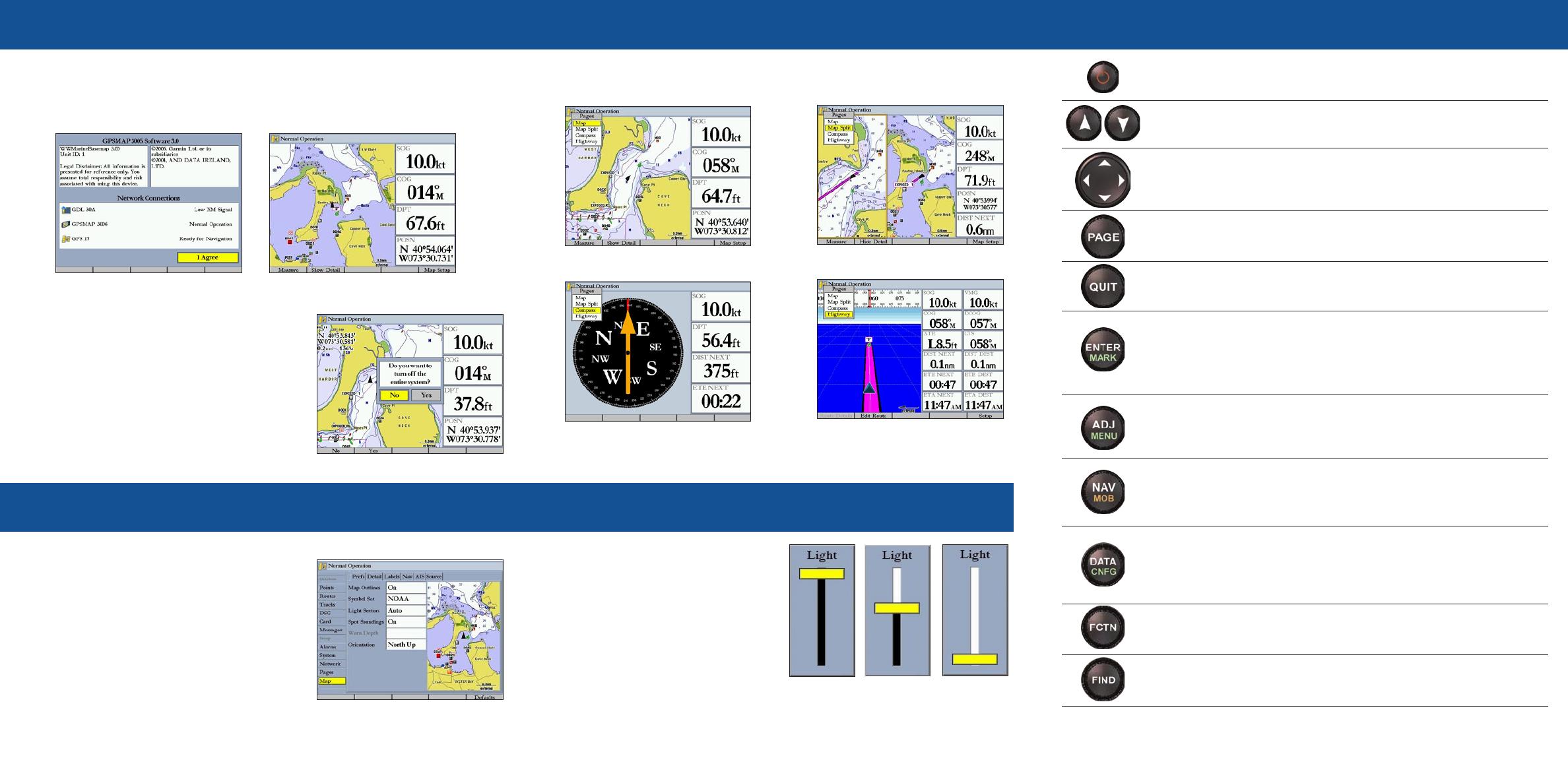
To turn on the GPSMAP 3005C:
1. Press and hold the POWER key.
2. When the I Agree on-screen button is highlighted, press ENTER to acknowledge the
warning and open the Map Page.
Startup/Shutdon Sequence
To change a setting using the Main Menu:
1. From any page, press and hold ADJ/MENU
to open the Main Menu.
2. Use the ROCKER to select a tab, and then press
right or left on the ROCKER to select a sub tab.
3. Highlight the eld you want to change, and
press ENTER.
4. Make any changes, and press ENTER.
5. Press QUIT to return to the main page.
Using the Main Menu
ADJ—press to show available options and features for the current
function.
MENU—press and hold to open the Main Menu.
POWER/BACKLIGHT—press and hold to turn the unit on or off.
Press and release to adjust the screen backlighting.
PAGE—press to cycle through the main pages in sequence and return
from a sub page to a main page.
QUIT—press to return to a previous page, restore a data eld’s
previous value, and exit out of menus.
ENTER—press to select highlighted elds, conrm menu options and
enter data.
MARKpress and hold for two seconds to capture your current location
and open the Review Waypoint Page.
NAV—press and release to access navigation options.
MOB (Man OverBoard)—press and hold to mark your current location
and instantly set a return course.
RANGE—press up to increase, or press down to decrease the range of
the Map Page, Highway Page, and other range-related functions.
ROCKER—press up, down, right, or left to move through lists,
highlight elds, select options and locations, enter data, or move
the map pointer.
FIND—press to initiate the Find option, so you can search for user
points, map items, and any optional data card information.
DATA—press to toggle the display of a main page with or without
function windows and data elds.
CNFGpress and hold to open the Conguration window to customize
main pages.
Using the GPSMAP 3005C Keypad
190-00531-01 Rev. B © Copyright 2005, 2006 Garmin Ltd. or its subsidiaries Printed in Taiwan
The GPSMAP 3005C contains four main pages. Additional main pages appear as you add
optional hardware to the Garmin Marine Network. Press PAGE to view each page.
Vieing Main Pages
Adjusting the Backlight
To adjust the backlight level:
1. Press and release the POWER key.
2. Press up or down on the ROCKER to
adjust the backlight level.
3. Press ENTER to quit.
FCTNpress to highlight the next available Function window on the
split screen.
To turn off the GPSMAP 3005C:
1. Press and hold the POWER key.
If one MFD is connected, the unit shuts down. If
multiple MFDs are connected, a prompt appears.
2. Select Yes to turn off the entire network, or select
No to put the unit in sleep mode
3. Press ENTER.
Map Page
Map Split Page
Highay Page
Compass Page
Main Menu
Warning Page
Map Page
Highest Selectable
Loest
1 / 1

Garmin GPSMAP 3005C Reference guide

Category
Navigators
Type
Reference guide

Garmin GPSMAP 3005C is a powerful marine chartplotter that offers a wide range of features to help you navigate safely and efficiently on the water. With its intuitive interface and user-friendly design, the GPSMAP 3005C is easy to use even for beginners. It comes preloaded with a detailed map of the coastal waters of the United States, and you can add additional maps for other regions of the world. The GPSMAP 3005C also includes a variety of navigation features, such as the ability to create and follow routes, mark waypoints, and track your progress.

Ask a question and I''ll find the answer in the document

Finding information in a document is now easier with AI

Ask the document