Page is loading ...

G E O T R A N S I T
OPERATORS MANUAL
1 Orientation ........................................................................ Page(s): 1
2 Magnetic Declination ....................................................................... 5
3 Azimuth Measurement .................................................................... 7
4 -- Inclination & Percent Grade Measurement ............................... 11
5 Strike & Dip Measurement ............................................................ 14
6 Trend & Plunge Measurement ..................................................... 15
7 GEO Transit & Topographic Map Use ......................................... 16
8 Additional Measurements ............................................................ 18
9 Prospecting ..................................................................................... 19
10 Reference Material ....................................................................... 25
11 Specifications ................................................................................ 26
12 Service ............................................................................................ 26
i
Copyright BRUNTON, 2001
Printed in U.S.A.
form 11-GEO rev. 0109
Owners Purchase Record
Model _______________________________________________________
Date of Purchase ______________________________________________
Dealer Purchased From: _________________________________________
_____________________________________________________________
Serial #:

Congratulations on your purchase of the finest pocket transit instrument in the world.
The Brunton GEO Transit is not just a compass. It combines a surveyors compass, pris-
matic compass, two inclinometers, hand level and a plumb into a single instrument.
Even though the GEO Transit is made rugged and durable to withstand the rigor associ-
ated with outdoor use, care must be taken to assure long-life of your instrument. Avoid
impacts, dropping, extreme temperatures and store the Brunton GEO Transit in its case.
Orientation provides a description of important
pocket transit parts. A detailed description of its
operation is provided throughout the manual.
Opening The GEO Transit
Position the GEO Transit so that the flat cover
faces up with the small window positioned away
from you. Unlatch the cover from the base.
(Fig 1)
1.1 Round Level (Fig 2)
For accurate azimuth measurement, dip direction and trend measurements, center the bubble
in the round level.
1.2 Needle (Fig 2)
The needle is attached to a rare earth magnet which is induction damped, allowing the needle
to seek magnetic north and come to a complete rest in a minimum amount of time.
1.3 Graduated Circle (Fig 2)
In combination with the needle, the 1° graduated circle allows for azimuth readings that are
accurate to 1/2 degree.
1.4 Long Level (Fig 2)
The long level is for inclination measurement. For accurate inclination measurement, center
the bubble in the long level using the vernier adjustment (section 1.14).
1.5 Rare Earth Magnet (Fig 2)
Brunton has incorporated a cast NdFeB, rare-earth magnet which seeks magnetic north very
quickly and allows for faster needle settling.
1.6 Zero Pin (Fig 2)
The zero pin a pointer used for magnetic declination adjustment. If no adjustment is
necessary, the pin should point at 0° on the azimuth ring.
1.7 Needle Release Mechanism -- 2-Positions (Fig 2)
Unlocked: When needle locking adjustment (section 1.15) is unlocked the needle swings
freely, even when needle release mechanism is pressed.
Locked: When needle locking adjustment is in the locked position the needle is locked in
place until the needle release mechanism is pressed. (Suggested for Storage)
1 -- Orientation
21
1.3
1.4
1.5
1.2
1.1
1.8 1.7
1.6
1.10 1.9
Figure 1
Figure 2
Flat Cover
Small Window

1.13 Large Sight w/ Peep Sight (Fig 3)
The large sight and the attached buckhorn style peep sight are used for precise azimuth and
inclination measurement.
1.14 Vernier Adjustment (Fig 3)
The vernier adjustment rotates the vernier and long level for inclination measurements.
1.15 Needle Locking Adjustment -- 2-Positions (Fig 3)
Adjust the needle locking lever to lock and unlock the needle.
1.16 Side/Bottom Long Levels (Fig 3)
When it is not possible to view the round level, use the side/bottom, long levels to level the
GEO transit for azimuth and inclination measurement .
1.17 Hinge Inclinometer (Fig 3)
Measure inclination using the lid and at least one of the bubble levels.
Storage
For storage, Brunton recommends locking the
needle adjustment lever (1.15) and placing the
GEO transit in its case, with the base against the
closing snap. (Fig 4)
Direct Reading
Why are EAST & WEST switched?
The GEO Transit is a direct reading compass.
Read azimuth directly where the needle points
on the graduated circle.
With the large
sight toward the object, read azimuth directly where the north end of the nee-
dle points (N tip). (Fig 5)
1.8 Vernier (Fig 2)
The vernier is used for inclination measurements with an accuracy to 30 minutes.
1.9 Mirror (Fig 2)
The mirror and mirror center line are used for accurate azimuth and inclination measurements.
1.10 Small Sight (Fig 2)
Attached to the cover, the small buckhorn style sight is used for precise bearing and inclina-
tion sighting.
1.11 Ball & Socket Tripod Mount (Fig 3)
Use the slots on both sides of the body for mounting the GEO to the optional Brunton ball &
socket mount, which in turn attaches to an optional Brunton tripod, or monopod.
1.12 Magnetic Declination Adjustment Screw (Fig 3)
Adjust the GEO Transit for magnetic declination, by turning the declination adjustment screw
using a flat-head screw driver.
43
Figure 4
Base
Figure 3
1.11
1.13
1.12
1.15
1.16
1.14
1.17
Snap

With the small sight toward the object, read azimuth directly where the south end of the nee-
dle points (S tip). (Fig 6)
See section 4 for detailed explanation of sighting an azimuth.
The Earth is completely surrounded by a magnetic field, and an unobstructed magnetized
object will orient itself with the earths magnetic north and south poles. Magnetic declination
(variation) is the difference between true, geographic north (North Pole) and magnetic north
(in northern Canada), with respect to your position. It is important to note magnetic declina-
tion at your position
, because magnetic declination varies and fluctuate slowly at different
rates, around the world.
The isogonic chart (Fig 7) shows North America, only. Use the isogonic chart, a current
United States Geological Survey (USGS), Bureau of Land Management (BLM), another
map, or a computer program to determine magnetic declination at your position.
Declination can be east, west or 0°, from your current position. At 0° declination, true north
and magnetic north are aligned.
Example: If magnetic declination at your position is 15° east, then mag-
netic north is 15° east of true, geographic north. Figure 8 displays true
geographic north and magnetic north, as indicated in the legends of
USGS and BLM maps.
Most maps use true north as a reference. When adjustment for magnet-
ic declination is complete, azimuth readings will be with respect to true
north, same as the map.
True North
Magnetic North
15
o
E
Your Position
Figure 8
Figure 7
West Declination
East Declination
65
Object
Large Sight
N Tip
Figure 5
Small Sight
S Tip
Object
Figure 6
2 -- Magnetic Declination

2. Rotate the needle locking adjustment lever clock-wise.
(Fig 10)
Now the needle swings freely, even when needle release
mechanism is pressed.
3.1.b Needle Locked (Locked)
1. Position GEO transit so that the base faces you with the
needle locking adjustment on top. (Fig 10)
2. Rotate the needle locking adjustment lever counter
clock-wise.
The needle remains locked until the needle release mechanism is pressed. When the needle
settles, let up on the release mechanism to lock azimuth measurement in place.
3.2 Azimuth Using a Tripod or Monopod
For highest accuracy, mount the GEO transit on a Brunton non-magnetic tripod using the
Brunton ball and socket head.
1. Adjust GEO transit for magnetic declination.
! See section 2, Magnetic Declination, for help.
2. Mount transit to the ball and socket head.
3. Open the cover and large sight until they both
extend in a straight line. (Fig 11)
4. Flip small sight and peep sight up.
5. Rotate transit until large sight points at object.
6. Level the transit by centering bubble in round level.
7. Sight azimuth by aligning
peep-sights with object.
(Fig 12)
Using the magnetic declination adjustment (1.12, pg. 3), rotate the graduated circle to adjust
for declination. Begin with the zero pin at 0°. For East declination, rotate graduated circle
clockwise from the zero pin. (Fig 9A) For West declination, rotate graduated circle count-
er-clockwise. (Fig 9B) If magnetic declination is 0°, no adjustment is necessary. (Fig 9C)
Azimuth is a term used for direction. Azimuth is normally measured clockwise, in degrees with
true north being 0°. Bearing is a term often used when measuring with a quadrant type instru-
ment. From this point forward, description of pocket transit use will involve the 0° through 360°
graduated circle, and with the assumption the GEO transit is adjusted for magnetic declination.
Example of Azimuth: If a mountain is directly east of your position, the azimuth from your posi-
tion to the mountain is 90°. If the mountain is directly south, it would be at 180°.
Warning:
The magnetic needle is highly sensitive. When sighting an azimuth, keep the GEO
transit away from magnetic materials, such as watches, belt buckles, rings, knives, etc.
3.1 Needle Locking Adjustment
Before measuring an azimuth a decision must be made to have the needle swing freely, or be
locked until the needle release mechanism is pressed.
3.1.a Needle Swings Freely (Unlocked)
1. Position the GEO so that the base faces you and the needle locking adjustment is on top.
Figure 11
87
Zero Pin
Zero Pin Zero Pin
Figure 9A Figure 9B Figure 9C
15° East
Declination
15° West
Declination
0°
Declination
Figure 10
Figure 12
Object
Adjustment
3 -- Azimuth Measurement

8. Read azimuth where the "N" end of the needle points at
graduated circle. (Fig 13)
3.3 Azimuth Measurement Waist-Level
This method is often used when object is above or below
the observer.
3.3.a Using "N" End of Needle
Use this method when the object lies as much as 45°
above, or 15° below the observer.
1. Hold transit waist high and in your left hand.
2. Open cover toward your body . (Fig 14)
3. Open large sight, until perpendicular to the body.
(Fig 14)
4. Press left forearm against
your waist and steady with
right hand.
5. Level compass using round
bubble level.
6. In the mirrors reflection, bisect the object with the mirror center
line. (Fig 15)
! Check that the bubble is centered in the round level.
7. Read azimuth where the "N" end of needle points at the graduated
circle.
If object is more than 45° above you, open mirror further toward your
body, and adjust large sight so that it leans over the bottom case.
3.3.b Using "S" End of Needle
Use this method when object is more than 15° below the observer.
1. Hold transit waist high and in your left hand.
2. Open cover away from your body. (Fig 16)
3. Open large sight until it leans over the body.
4. Press left forearm against your waist and steady with
right hand.
5. Look just over the large sight, and at the object
through window opening on mirror. (Fig 16)
! Adjust mirror and large sight so that the image of
the large peep sight are bisected by the mirror
center line.
6. Level compass using round bubble level.
7. Read azimuth where the "S" end of needle points at
the graduated circle. (Fig 17)
3.4 Using as a Prismatic Compass
Occasionally, objects may interfere with sighting using meth-
ods previously mentioned, or users may encounter circum-
stances which require the GEO be held at eye-level to sight
an object. If this is the case, follow the procedures below.
1. Open cover away from your body to approximately 45°, and open small sight. (Fig 18)
2. Lift large sight until perpendicular to the transit body, or leans slightly away from the base.
3. Hold instrument at eye-level, with large sight toward you.
4. Align large sight and small sight on top of the cover with
object.
! OR - Sight object through the lower portion of large sight
and the window in the mirror.
5. Level round bubble level using the reflection of the mirror.
6. Read azimuth in the reflection of the mirror where the "S"
end of needle points at the graduated circle.
Figure 18
TO EYE
Figure 17
109
Figure 15
Figure 16
Figure 13
Figure 14
TO EYE

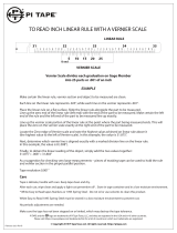
2. Find minutes by determining whether the 30 or 60 minute line is closest to a degree
marking. See arrows in figure 21. A Loupe or magnifier may be required.
Since the 30 minute line is closest, the total angle is 26° + 30 (26° 30 or 26.50°)
4.1.b -- percent grade
Use the percent grade scale above the vernier.
1. Read nearest percent grade at the verniers
center line -- 50%, circled. (Fig 22)
Another method is to calculate the percent grade
using the angle of inclination and the equation:
Percent Grade = [ tan(
"#
) x 100 ]
Measure the angle of inclination,
"
= 26.5°. Then, calculate the tangent of 26.5° using a cal-
culator. Finally, move the decimal two places to the right (multiply by 100).
Example:
Tan( 26.5°) = .499 = 49.9% Grade
4.2 Inclination Using Prismatic Compass
The GEO transit can also measure angles of inclination without a tripod.
1. Position cover to approximately 45°.
2. Open large sight and flip its peep sight to 90° from
the large sight. (Fig 23)
3. With large sight pointing toward you, position transit
at eye-level with cover open to the right. (Fig 23)
4. Sight object behind transit, aligning small sight,
window and peep sight with object.
5. In the mirror, adjust vernier until bubble is centered in
the long level .
6. Read inclination at verniers center line.
The Brunton GEO Transit is capable of measuring vertical angles with an accuracy better
than 1°, with readings to 10 minutes. Also, it
displays percent grade, without calculation.
The bottom scale is incremented from 0° to 90°
and is used for vertical inclination. The scale on
the vernier is also used for vertical (inclination)
measurement, but it is incremented from 0 to 60
minutes. (Fig 19) Closer to the center, the sec-
ond scale increments from 0% to 100%. This
scale is the percent grade scale.
4.1 Inclination and Percent Grade Using Tripod or Monopod
Use a tri/monopod for increased inclination accuracy.
1. With GEO transit attached to the tripod tilt the ball
and socket mount 90°. (Fig 20)
! Transit should be on its side.
2. Lock into position using the clamp screw.
3. Align sights with object behind transit. (Fig 20)
4. Adjust vernier until bubble is centered in long level.
5. Read inclination at verniers center line from the
degree scale -- 26° to 27°, circled. (Fig 21)
4.1.a -- inclination to the nearest 30 minutes
When 30 minute accuracy is required, use the
vernier scale (0 -- 60 minutes with 10 minute incre-
ments).
1. Read inclination at verniers center line --
26° + __ , circled. (Fig 21)
1211
Figure 19
Figure 21
Figure 22
Figure 20
Figure 23
TO EYE
4 -- Inclination & Percent Grade Measurement

Strike & dip measurements are planar measurements
taken when direct contact is made with the outcropping.
5.1 Strike Measurement
Strike is the direction of a line that is formed by an inter-
section of an imaginary horizontal plane and an inclined
surface that is being measured.
1. Open both the cover and large sight until both extend in
a straight line.
2. Place transit along a horizontal line on the inclined rock
surface. (Fig 26)
! Hint: Place on a writing tablet to extend the horizontal line.
3. Hold level by centering bubble in the round level.
4. Read strike angle at either the N or S tip.
Some people recommend the strike measurement be the largest angle out of N and S, so
that there is no confusion between the strike and dip angle.
5.2 Dip Measurement
Dip is the vertical angle (inclination) of the rock surface, measured from horizontal.
1. Open the cover and large sight until they both extend in a straight line.
4.2.a Height Measurement Using Vertical Angles
1. Sight inclination, as described in section 4.2.
2. Apply height calculation as shown in figure 24A or 24B.
Note: Do not calculate tangent of an angle by adding tangents of two smaller angles.
Example: Tan(60°)
$
Tan(30°) + Tan(30°) Find Tan(60°) from a table, use a calculator, or
step back until angle of inclination is less than 45°, then use tangent table on the GEO lid.
4.2.b Height Measurements Using % Grade
1. Sight % grade using level or sloping ground, same as in Figures 24A & 24B.
2. Apply height calculation, as show in figures 25A & 25B.
1413
Below Object Base
Height = (TanA - TanB) x Distance
Example: A = 38°, B = 10° & Distance = 75 ft.
Height = (Tan38° - Tan10°) x 75
Height = (.781 - .176) x 75
Height = (.605) x 75
Height = 45.38 ft. = 45
Above Object Base
Height = (TanA + TanB) x Distance
Example: A = 36°, B = 10° & Distance = 50 ft.
Height = (Tan36° + Tan10°) x 50
Height = (.727 + .176) x 50
Height = (.903) x 50
Height = 45.15 ft. = 45
Above Object Base
Height = (A + B) x Distance
Example: A = 72.7%, B = 17.6% & Distance = 50 ft.
Height = (72.7% + 17.6%) x 50
Height = (.903) x 50
Height = 45.15 ft. = 45
Below Object Base
Height = (A - B) x Distance
Example: A = 78.1%, B = 17.6% & Distance = 75 ft.
Height = (78.1% - 17.6%) x 75
Height = (.605) x 75
Height = 45.38 ft. = 45
Figure 25A Figure 25B
Figure 24A
Figure 24B
Height Measurement
Above
Object Base
Height Measurement
Below Object Base
Figure 26
5 -- Strike & Dip Measurement

2. Stand on top, or behind the lineation and face the
direction of the plunge.
3. Hold compass at waist level and look down through the long
sight, aligning the pencil with the long sight. (Fig 29)
4. When bubble is centered in the round level, read the
trend at S end of the needle.
6.2 Plunge Measurement
Plunge is the inclination between the lineation and a
horizontal line.
1. Move to the side of the lineation, or right angles to its
trend.
2. Open both the cover and large
sight until they extend in a straight line.
3. Measure plunge using a Brunton non-
magnetic tripod, or by holding the transit
in your hand. (Fig. 30)
A United States Geological Survey (USGS) topographic map is a 2-dimensional drawing of 3-
dimensional terrain. Hills, valleys, ridges, cliffs and other terrain are represented through a
series of contour lines. Each line represents constant elevation in feet or meters above sea
level. Find the contour interval in the legend of the topographic map. With practice, youll
begin to recognize contours, labeling and identify passable routes.
Figure 29
2. Place GEO on its side and along on the rock surface, so
the vernier scale is at the bottom. (Fig 27)
3. Adjust vernier until bubble is centered in long level.
4. Read dip angle at the verniers center line, bottom scale.
5.3 Dip Measurement using Hinge Inclinometer
This method uses the lid hinge inclinometer.
1. Place transit hinge next to the outcropping. (Fig 28)
2. Adjust cover to the angle of the outcropping.
3. Hold level by centering bubble in the round level.
4. Read dip angle at the
hinge inclinometer scale.
Hint: If the GEO transit is not in a position to view the round
level, use the side/bottom long levels.
5.4 Dip Direction
After measuring dip using the hinge inclinometer, now
measure the dip direction.
1. With hinge next to outcropping and GEO transit level,
measure the dip direction. (Fig 28)
2. Read dip direction at the S tip.
Trend and plunge are usually non-contact linear measurements, unlike strike and dip which
are planar measurements. However, both methods provide similar information.
6.1 Trend Measurement
Trend is the direction that the lineation points downward (plunges).
1. Place a pen, pencil, or anything straight in the direction the lineation points down (plunges).
1615
Figure 28
Figure 27
Figure 30
6 -- Trend & Plunge Measurement
7 -- GEO Transit & Topographic Map Use

1. Identify three landmarks in the field,
that are identifiable on a topo-map.
2. Orient map to true north (see section
7.1)
3. Sight an azimuth to each landmark
and mark them on the map. (Fig 33)
4. Draw a line on the map for each
landmark azimuth.
5. Your position is within the small tri-
angle, or point formed by the intersec-
tion of the three lines. (Fig 33)
8.1 Level
The GEO transit can be used as a level, to run level lines, or to determine points of elevation.
1. Adjust Vernier to 0° inclination, using the vernier
adjustment.
2. Place transit on its side, on an object, or
use the tripod. (Fig 34)
3. Tilt instrument until bubble is centered in the long
level.
8.2 Plumb Bob
1. Suspend the transit in an open position from
the large sight -- See right image figure 35.
2. Use the small sight as the pointer.
7.1 Map Azimuth
It is possible to read a map azimuth from your position
to a destination. Orient your map to true north, then
determine a map azimuth by using the GEO transit.
1. On a USGS topographic map, place a point at a
starting position and an X at a destination.
2. Draw a line connecting both marks.
3. At the starting point, draw a true north line.
(Fig 31)
!# Use true north indicator in the legend, or the
edge of printed topographic map.
4. Adjust GEO for declination.
5. With large sight pointing at true north on the map,
place tranist along edge of printed map.
6. Rotate map and compass until the N points at 0°.
(Fig 31)
The map is aligned to true north. Now, determine the
azimuth from Start to the Destination.
7. Position the GEO transit so the large sight points
at the destination and is next to the azimuth line.
(Fig 32)
8. Read azimuth where the N points.
From the Start position in the field, sight the azimuth determined from the map, and you will
be facing the Destination. See section, 3 - Azimuth Measurement
, for help.
7.2 Triangulation
Use Triangulation to find your approximate position, using the GEO and a map. Make sure the
GEO is adjusted for magnetic declination.
1817
Figure 34
Figure 35
Figure 31
Figure 32
Figure 33
Baldy Peak
Boat Ramp
Beaver Falls
Your Position
50°
90°
320°
8 -- Additional Measurements

3. Federal Requirements - The location of the claim must be distinctly marked on the ground
so that its boundaries can be readily traced. All records of mining claims shall contain the
name, or names of the locators, the date of the location and such a description of the claim
or claims located by reference to some natural object or permanent monument as will iden
tify the claim.
4. State Requirements - Each mining district may make regulations not in conflict with the
laws of the United States, or with the laws of the state or territory in which the district is
situated governing the location, manner of recording and amount of work necessary to hold
position of a mining claim. This means the details of location are left to each state.
5. Type of Claims - There are four types of claims: lode claims, placer claims, mill sites, and
tunnel sites. Only lode claims are discussed here.
6. Lode Claims - A lode is defined as a zone or belt of mineralized rock lying within
boundaries clearly separating it from the neighboring rock. The dimensions of a lode claim
are a maximum of 1,500 feet along the lode or vein, and no more than 300 feet to either
side of the vein; end lines must be parallel.
Following, is an example of state regulations -- Nevada lode claim location requirements.
1. Erect a discovery monument at the point of discovery, and post thereon a location notice
containing: (a) the name of the claim, (b) the name and mailing address of the locator, (c)
the date of location, (d) the number of linear feet along the vein each way from the
discovery monument, with the width claimed on either side of the vein, and (e) the general
course of the vein. (NRS 517.010)
2. All monuments must consist of (a) a tree cut of 3 or more feet above the ground and blazed,
(b) a rock pile 3 or more feet in height, or (c) a 4-inch diameter post at least 4 1/2 feet in
length set 1 foot in the ground. (NRS 517.030)
3. Within 20 days of posting the location notice, mark the boundaries of the claim by placing
monuments at the four corners and center of each side line. (NRS 517.030)
4. Within 90 days of posting the location notice, prepare two copies of a claim map (scale
of 500 feet to the inch) showing the position of the claim monuments, the relationship
of the claim monuments and the relationship of the claim group to a survey corner, or claim
8.3 Inclination
1. Position GEO on its side and on top of the object with the vernier down. (Fig 35)
2. Rotate vernier adjustment until the bubble is centered in the long level.
3. Read inclination in degrees or % grade.
If you were to discover gold, silver, or another valuable mineral deposit, you would want to
stake a claim. It would be necessary to construct a map of your claim, and tie (locate) your
claim relative to some known position. Your Brunton GEO transit is ideally suited for this job,
since it is a modification of the same instrument used by geologists, mining engineers for
prospecting and mapping around the world, since 1896.
9.1 Laws Governing Prospecting
In 1872 the General Mining Laws were enacted, and since then more laws have been passed
governing the western United States. Currently, state laws vary widely and the federal
laws concerning mining claims are quite vague. A discussion of the law is beyond the
scope of this manual and it is strongly advised that you contact your state and federal
agencies for information concerning staking a claim.
For a basic understanding, following is general information on mining claims.
RULES AND LAWS MAY HAVE CHANGED.
1. Lands Open to Mining Claims - Lands available for mining claims can be determined by
examining records from the Federal Land Office and the U.S. Bureau of Land Management
(BLM), for your state. Generally, mining claims are limited to western states, where public
land still exists. This includes public lands administered by the U.S. Forest Service, and
U.S. BLM. It excludes national parks, monuments, state owned land and privately owned
lands.
2. Qualification -- An individual must be a United States citizen, or one who has declared
their intention to become a citizen. A corporation must be organized under the laws of the
United States, or one of the fifty states. There are no restrictions as to age or residency.
2019
9 -- Prospecting

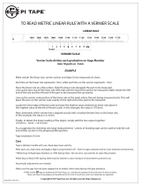
9.2 Surveyed Land
In locating your mining claims and
constructing your claim location
map, it will be helpful to understand
how lands are divided up by the rec-
tangular system of surveys. This
system is the basis for the identifica-
tion, administration and disposal of
public lands.
Figure 35 illustrates how lands are
divided by survey. Lines running
north-south are called range lines.
R22E stands for Range 22 East of
the principal meridian. Lines running east-west are township lines. T22S stands for Township
22 South of the base line. On a topo-map, the range lines are shown at the top and bottom of
the printed map. Township lines are shown on the east-west margin of the map.
By specifying the township and range, a township area of land is located. The large squares
in figure 27 are townships. For example, T22S, R22E specifies the township area with 36 sec-
tions, each numbered and 1 mi
2
(640 acres) apiece. This makes a township is 36 mi
2
. A 1mi
2
section of land is located by calling out the section number, township and range -- Section 4,
T22S, R22E.
A section is further divided into quarter sections by straight lines connecting quarter section
corners or opposite boundaries. There are eight monuments on each section. One monument
on each corner and one midway between corners on the section boundary lines (not shown).
If your claim is in a surveyed area of public land, it will be located within a section shown on a
topo-map. To locate your claim, it is then necessary to tie, or locate your claim relative to a
section corner monument. The corner monument may be a pipe with a brass cap fastened to
the top. It may be a brass tablet. 3 1/4 by 3 1/2 inches, attached to a rock outcropping and
location marker. The marker must be a rock pile 4 feet in diameter and 4 feet high, or a
steel post 3 inches in diameter and 5 feet high. The description must also include the sec
tion, township and range. The map need not be perfect, but in accordance with the
locators abilities. (NRS.030) The maps must then be filed with the county recorder. (NRS
517.040 (2))
5. Within 90 days of posting the location notice, record duplicate location certificates with the
county recorder containing the following information *(NRS 517.050):
a. The name of the lode or vein.
b. The name of the locator or locators, together with the post office address of such
locator or locators
c. The date of the location.
d. The number of linear feet claimed in length along the course of the vein each way from
the point of discovery with width of each side of the center of the vein, and the
general course of the lode or vein as near as may be.
e. A statement that the location work consisted of making the maps as provided in (NRS
517.040).
f. The location and description of each corner, with the markings thereon.
6. Only one location may be claimed on each location notice or location certificate (NRS
517.020, 517.050).
7. Penalty for late recording: any record of the location of a lode mining claim which shall not
contain all the requirements named in this section recorded on or after July 1, 1971, shall
be void, and every location of a mining claim recorded on or after July 1, 1971, shall be
absolutely void unless a certificate of location thereof substantially complying with the
above requirements is recorded with the county recorder of the county in which the claim
is located within 90 days after the date of location. (NRS 517.050 (2))
Other states require some form of discovery work other than preparation of a map. This may
consist of digging a shaft or drilling a specified footage of discovery holes. Check the mining
statutes of the desired state to determine its specific requirements.
2221
Figure 35

unsurveyed areas (no corner post to locate, or tie your claim), you must locate your claim in
reference to some natural land mark. A natural land mark being a mountain top, intersection
of a river and a stream, etc.
9.4.a Using Bearing & Distance
Figure 38 shows a claim tied to Blue
Mountain Peak by an azimuth of 81°,
and a distance to Blue Mountain Peak
of 7,000 feet from a corner monument.
9.4.b Using Two Bearings
The claim in figure 39 is tied to two
azimuth readings from a corner monument. Using this method, distance is not required, since
the intersection of both azimuth lines deter-
mine the location.
9.4.c Using Five Bearings
For a more complete description of your
claim, determine the direction of its sides. The
angles are found by standing on corner #1 and
taking an azimuth to corner #2. Then standing
on corner #2 and taking an azimuth to corner
#3. Finally, from #3 to #4 and from #4 back to
#1, thus completing the description. (Fig. 40)
set in concrete. The brass is marked with let-
ters and figures that give the section, township
and range. It is marked so that it must be read
while standing on the south side of the monu-
ment. The south side of the monument is
marked with the date of the monument.
(Fig 36)
9.3 Sample Claim Location Map
Figure 37 shows the location monument with claim extending 300 feet to each side of the vein
center line and 1,500 feet long. The claim is tied or located to a section corner post by show-
ing the bearing to the corner post, the number of feet to the post and the section, township
and range.
Obtain a bearing selecting one of your claim corners as your tie point, and sighting from the
tie point to the section corner post. The azimuth to the South East corner of Section 32, T22S,
R22E was found to be 110°. (Fig 37) Note, the distance to the section corner must also be
provided.
9.4 Location On Unsurveyed Land
Not all of the U.S. has been surveyed.
As of 1970, about 500,000,000 acres
were still unsurveyed. Most of the
unsurveyed land is located in mountain-
ous sections of the country. Since then,
however, more has been surveyed.
Check with the Federal Land office, or
the U.S. Bureau of Land Management
of your state.
If your claim is located in one of the
23 24
Figure 37
Figure 38
Figure 39
Figure 36
Figure 40

Specifications include Brunton model 5009 & 5010 GEO transits.
Magnetism: NdFeB Magnet (rare earth magnet)
Accuracy: Bearing -- +/- 1/2° accurate
Inclination -- +/- 1° accurate (30 minute readable)
Size (Closed): Length -- 9.45 cm (3.72 in.)
Width -- 7.06 cm (2.78 in.)
Height -- 3.43 cm (1.35 in.)
Weight -- 289 g (10.2 oz.)
Engraving - Personalize the Brunton GEO Transit with engravings (up to 18 characters,
including spaces). Call Brunton at (307) 856-6559 for details.
Balancing - Brunton GEO transits must be balanced for use in specific regions of the world.
If using the GEO outside North America, the GEOs needle may need to be balanced. Call
Brunton at (307) 856-6559 for details.
Repair / Service - Bruntons repair department is capable of handling repairs, or conversions
of any genuine Brunton Pocket, or GEO transits. Periodic maintenance and calibration is high-
ly recommended and will prolong the life of your pocket transit. Call Brunton at (307) 856-6559
for details.
A description of the claim, shown in Figure 40, would read:
Beginning at Corner #1, NE corner: Thence 600 feet, 290° to Corner #2. Thence 1,500 feet,
200° to Corner #3. Thence 600 feet, 110° to Corner #4. Thence 1,500 feet, 10° to Corner #1.
Inches
1/8
1/4
3/8
1/2
5/8
3/4
7/8
1
2
3
4
5
6
12
Feet
0.0104
0.0208
0.0313
0.0417
0.0521
0.0625
0.0729
0.0833
0.1667
0.2500
0.3333
0.4167
0.5000
1.0000
mm
3.1750
6.3500
9.5250
12.700
15.875
19.050
22.225
25.400
50.800
76.200
101.60
127.00
152.40
304.80
cm
.31750
.63500
.95250
1.2700
1.5875
1.9050
2.2225
2.5400
5.0800
7.6200
10.160
12.700
15.240
30.480
Conversions
1 inch = 2.54 centimeters
1 foot = 12 inches
1 foot = 0.305 meters
1 yard = 3 feet
1 yard = 0.914 meters
1 chain = 66 feet
1 mile = 5,280 feet
1 mile = 80 chains
1 mile = 1.609 kilometers
1 acre = 43,500 feet
2
1 acre = 0.4047 hectares
Conversions
1 centimeter = 10 millimeters
1 centimeter = 0.01 meters
1 centimeter = 0.394 inches
1 meter = 100 centimeters
1 meter = 3.281 feet
1 meter = 1.094 yards
1 kilometer = 1,000 meters
1 kilometer = 0.6214 miles
1 hectare = 10,000 meters
2
1 hectare = 2.471 acres
SIN(
"
) = A/C CSC(
"
) = C/A
COS(
"
) = B/C SEC(
"
) = C/B
TAN(
"
) = A/B COT(
"
) = B/A
A = Side opposite angle
"
B = Side adjacent to angle
"
C is the hypotenuse
C
2
= A
2
+ B
2
25 26
10 -- Reference Materials
11 -- Specifications
12 -- Service
/