Garmin eTrex Legend eTrex Vista H Quick start guide

Category
Navigators
Type
Quick start guide

This manual is also suitable for

To mark your current location as a waypoint:
1. Press and hold the ROCKER until the Mark
Waypoint page appears. A default three-digit
name is assigned to the new waypoint.
2. To accept the waypoint with the default
information, select OK.
OR
To change any information, select the
appropriate eld, and press ENTER to open
the on-screen keypad. After entering and
conrming your changes, select OK.
To create a waypoint on the Map page:
1. Press PAGE until the Map page is shown.
2. Use the ROCKER to move the arrow to the point.
3. Press the ROCKER > Yes.
4. Edit the waypoint or press QUIT/PAGE to save.
To delete a waypoint:
From the Waypoints page, select the waypoint you want to
delete > Delete > Yes.
To reposition a waypoint to your current location:
1. From the Waypoints page, use the ROCKER to select the
waypoint you want to edit, and press ENTER > Menu.
2. Touch Reposition Here.
To navigate to a waypoint:
1. Press and hold FIND.
2. Select Waypoints, and choose a waypoint.
3. Select Go To. A line on the map indicates your course.
4. Press PAGE to display the Compass page.
5. Use the compass to navigate to your destination.
To navigate to a location using Find By Name:
1. Press and hold FIND to open the Find Menu.
2. Select the icon for the type of item you want to search for.
3. Press MENU > Find By Name.
4. Use the ROCKER to operate the on-screen
keypad, and enter the name of the location
you want to nd. When the Find list contains a
match, highlight OK.
5. Select the location item from the Find list,
and press ENTER. The item’s information
page opens, allowing you to save the item
as a waypoint, show the item on the map, or
navigate to the item (Go To).
To stop navigating:
From the Map page, press MENU > Stop Navigation.
December 2008 Part Number 190-00780-01 Rev. B Printed in Taiwan
Go to www.garmin.com for additional documentation and
information.
Creating and Using Waypoints
Navigating to a Destination
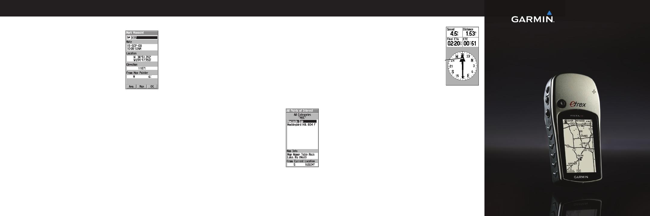
Using the Compass
To open the Compass page:
On the Main Menu, touch Compass.
Hold the compass level when navigating.
The bearing pointer points to your
destination, regardless of the direction
you are moving. If the bearing pointer
points toward the top of the compass,
you are traveling directly toward
your destination. If it points any other
direction, turn toward that direction until the arrow is pointing
toward the top of the compass.
To calibrate the electronic compass (Vista H only):
1. While outdoors, hold the Vista H level. Do not stand near
objects that inuence magnetic elds, such as cars, buildings,
or overhead power lines.
2. Press MENU > Calibration.
3. Select Start, and follow the on-screen instructions for holding
and turning the unit. “Calibration Successful” appears when
nished.
eTrex Legend
®
H and eTrex Vista
®
H
quick reference guide
Bearing
pointer
The eTrex operates on two AA batteries (not included). Use
Alkaline, NiMH, or Lithium batteries.
To install the batteries:
1. Remove the battery cover by turning the
locking ring ¼ turn counter-clockwise
and removing the cover.
2. Insert the batteries, observing polarity.
3. Replace the battery cover.
To select the battery type:
1. Press MENU twice > Setup.
2. Select System > Battery Type.
3. Select the battery type.
NOTE: Remove the batteries when you do not plan to use the
eTrex Legend H or Vista H for several months. Stored data is not
lost when batteries are removed.
To extend battery life:
Turn off the GPS when not using the eTrex for navigation.
Decrease the level of the backlight by quickly pressing and
releasing the POWER key.
eTrex Legend H and eTrex Vista H
Installing the Batteries
Key Functions
To turn the eTrex on and off:
Press and hold POWER.
To adjust the backlight level:
1. Press and quickly release the POWER key.
2. Press up on the ROCKER to increase the brightness and
down to decrease.
To acquire GPS satellite signals:
1. Go outdoors to an open area, away from tall buildings and
trees.
2. Turn the eTrex on. Acquiring satellite signals can take a few
minutes.
While the GPS receiver is searching for the satellite signals,
“Acquiring Satellites” appears until enough signals are acquired
to x its location.
Using the Status Bar:
The Battery Power icon
shows the remaining power
as the battery is depleted. The
external power icon is shown when the unit is powered
externally. Satellite signal status is shown when searching for or
acquiring satellites , a 2D x is attained, and a 3D x
is attained.
Getting Started
© 2008 Garmin Ltd. or its subsidiaries
MENU/FIND key
Press and release to view the Options Menu for the current page.
Press and hold to display the Find Menu.
ENTER/ROCKER key
Rock up, down, right, or left to move through lists; highlight
elds, on-screen buttons, or icons; move the map panning arrow.
Press in and release to enter highlighted options and data or
conrm on-screen messages.
Press in and hold at any time to mark your current location as a
waypoint.
QUIT/PAGE key
Press to cycle through the main pages.
Press and hold to turn the compass on or off (Vista H only).
POWER/Backlight key
Press and hold to turn on or off.
Press and release for backlighting or to view time, date, and
battery capacity.
QUIT/PAGE
POWER/
Backlight
IN/OUT ZOOM
ENTER/
ROCKER
MENU/FIND
IN/OUT Zoom keys
From the Map page, press to zoom the map in or out.
From any other page, press to scroll up or down a list or move a
highlighted slider.
See the Important Safety and Product Information guide in the product
box for product warnings and other important information.
  • Page 1 1
  • Page 2 2

Garmin eTrex Legend eTrex Vista H Quick start guide

Category
Navigators
Type
Quick start guide
This manual is also suitable for

Ask a question and I''ll find the answer in the document

Finding information in a document is now easier with AI