1313
190-00356-31 Rev. D
NOTE: SKYWATCH data is only displayed on the Map
Page if suitable aircraft heading data is available. See the
Garmin 400W or 500W Series Installation Manuals avail-
able at your authorized Garmin service center for details.
Traffic Page Display Range
YoucanchangethedisplayrangeontheTrafc
Pageatanytime.
1. Press the RNG Key to cycle through the fol-
lowing range options:
• SKYWATCH(SKY497)—2NM,2and6NM,and
6and12NM.
• SKYWATCHHP(SKY899)—2NM,2and6NM,
6and12NM,and12and24NM.
• Bendix/KingKTA870/KMH880—2NM,2and
6NM,6and12NM,12and24NM,and20and
40NM.
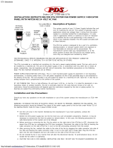
Configuring Traffic Data on the Map Page
Thedisplayoftrafcinformationisdesignedto
closelyresemblethedisplaysymbologyusedbyL-3
ontheSKYWATCH.Traffic is only displayed on
the Map Page if aircraft heading data is available.
When heading is not available, Traffic Advisories
are displayed as non-bearing banners on the Map
Page.
Selections for configuring traffic data are
made from the Map Setup Menu on the Map
Page.
To configure traffic on the Map Page:
1. Turn the small right knob to select the Map
Page.
2. Press MENU to display the Page Menu. Turn
the small right knob to select “Setup Map?”
and press ENT.
3. The flashing cursor highlights the GROUP field.
Turn the small right knob to select Traffic and
press ENT.
4. Turn the large right knob to select the desired
Traffic Mode option. Turn the small right knob
to select the desired option and press ENT.
Repeat the step for Traffic Symbol and Traffic
Label.
5. Return to the Map Page by pressing CLR.
Trafcmodeallowstheoperatortochoosewhich
trafcisdisplayed(alltrafc,trafcandproximityadvi-
sories,ortrafcadvisoriesonly).Thetrafcsymbolisthe
symbolusedtodepictthetypeoftrafc(400W/500W
SeriesandL-3usethesamesymbology):
•TrafcAdvisories(TA)—Yellow
•ProximityAdvisories(PA)—White
(maybeconguredasCyan)
•Other—White(maybeconguredasCyan)
NOTE: Proximity Advisories (PA) are displayed as
solid white diamonds (may be configured as cyan).
SKYWATCH shows these PAs as “other” (hollow dia-
monds). PAs are defined as traffic within the 4.0-NM
range, with ± 1200 feet of altitude separation, and not
a traffic advisory (TA).
Thetrafclabelisthealtitudeseparationaboveor
belowthesymbolandtheverticalspeedsensearrow
Section 3
Skywatch Interface