Kenwood DDX-512 - DVD Player With LCD monitor User manual
- Category
- Navigators
- Type
- User manual
This manual is also suitable for

GPS NAVIGATION SYSTEM
DNX5120
DNX512EX
GPS NAVIGATION
INSTRUCTION MANUAL
© B64-4184-00
190-00901-00_0A.indd 1190-00901-00_0A.indd 1 1/23/2008 11:37:55 AM1/23/2008 11:37:55 AM

2 DNX5120/DNX512EX GPS Navigation Instruction Manual
Getting Started 9
First Time Setup 9
The Map and Other Tools 16
Viewing the Map Page 16
Trip Computer 16
Turn List 17
GPS Info Page 17
Safety Precautions and Important
Information 4
Find It and Go! 10
Finding a Restaurant 10
Following Your Route 11
My Locations 14
Saving Places You Find 14
Saving Your Current Location 14
Setting a Home Location 14
Finding Saved Places 15
Editing Saved Places 15
Deleting a Saved Place 15
Creating and Editing Routes 18
Creating a New Saved Route 18
Editing a Saved Route 18
Adding an Intermediate Destination 18
Point to Your Route
Saving the Active Route 18
Navigating a Saved Route 18
Recalculating the Route 18
Deleting All Saved Routes 19
Stopping Your Route 19
Adding a Detour to a Route 19
Adding Avoidances 19
Where To? 12
Finding an Address 12
Finding a Place Using the Map 12
Understanding the Information Page 13
Finding Recently Found Places 13
Finding Places in a Different Area 13
Narrowing Your Search 13
Contents
190-00901-00_0A.indd 2190-00901-00_0A.indd 2 1/23/2008 11:37:57 AM1/23/2008 11:37:57 AM

English 3
Using the Logs 20
Adjusting the Track Log 20
Using the Mileage Logs 20
Changing the Settings 24
Changing the General Settings 24
Changing the Map Settings 25
Changing the Navigation Settings 26
Adjusting the Traffic Settings 26
Viewing Information (About) 26
Restoring the Settings 26
Appendix 27
Using the Remote Control 27
Updating the Software 27
Updating the Map Data 27
Clearing All User Data 27
Custom POIs (Points of Interest) 27
Traffic Information 21
Connecting the Traffic Module 21
Viewing Traffic Events 21
Avoiding Traffic 21
Traffic Symbols 22
Changing the Traffic Settings 22
Adding a Traffic Receiver Subscription 22
Icons used in this manual
Important precautions are described to prevent injuries etc.
Special instructions, supplementary explanations, limitations, and reference pages are described.
190-00901-00_0A.indd 3190-00901-00_0A.indd 3 1/23/2008 11:37:59 AM1/23/2008 11:37:59 AM

4 DNX5120/DNX512EX GPS Navigation Instruction Manual
Read this information carefully before starting to
operate the Kenwood Car Navigation System and
follow the instructions in this manual. Neither
Kenwood nor Garmin shall be liable for problems
or accidents resulting from failure to observe the
instructions in this manual.
2WARNINGS
To prevent injury or fire, take the following
precautions:
• To prevent a short circuit, never put or leave any
metallic objects (such as coins or metal tools) inside
the unit.
• Do not watch or fix your eyes on the unit’s display
when you are driving for any extended period.
• Mounting and wiring this product requires skills and
experience. For safety’s sake, leave the mounting
and wiring work to professionals.
Failure to avoid the following potentially
hazardous situations could result in an
accident or collision resulting in death or
serious injury.
When navigating, carefully compare information
displayed on the navigation system to all available
navigation sources, including information from
street signs, visual sightings, and maps. For safety,
always resolve any discrepancies or questions before
continuing navigation.
Always operate the vehicle in a safe manner. Do
not become distracted by the navigation system
while driving, and always be fully aware of all driving
conditions. Minimize the amount of time spent
viewing the screen of the navigation system while
driving, and use voice prompts when possible.
Do not enter destinations, change settings, or
access any functions requiring prolonged use of the
navigation system controls while driving. Stop your
vehicle in a safe and legal manner before attempting
such operations.
Keep the system volume at a low enough level to be
able to hear outside noises while driving. If you can
no longer hear outside noises, you may be unable
to react adequately to the traffic situation. This may
cause accidents.
The navigation system will not display the correct
current position of the vehicle the first time it is
used after purchase, or if the vehicle battery is
disconnected. GPS satellite signals will soon be
received, however, and the correct position will be
displayed.
Be careful of the ambient temperature. Using the
navigation system at extreme temperatures can
lead to malfunction or damage. Also note that the
unit can be damaged by strong vibration, by metal
objects, or by water getting inside the unit.
2CAUTIONS
Failure to avoid the following potentially
hazardous situations may result in injury
or property damage.
The navigation system is designed to provide you
with route suggestions. It does not reflect road
closures or road conditions, traffic congestion,
weather conditions, or other factors that may affect
safety or timing while driving.
Use the navigation system only as a navigational aid.
Do not attempt to use the navigation system for any
purpose requiring precise measurement of direction,
distance, location, or topography.
The Global Positioning System (GPS) is operated
by the United States government, which is solely
responsible for its accuracy and maintenance. The
government system is subject to changes that
could affect the accuracy and performance of all
GPS equipment, including the navigation system.
Although the navigation system is a precision
navigation device, any navigation device can be
misused or misinterpreted and, therefore, become
unsafe.
IMPORTANT INFORMATION
Vehicle Battery Preservation
This navigation system can be used when the ignition
key is turned to ON or ACC. To preserve the battery,
however, it should be used with the engine running
whenever possible. Using the navigation system for a
long time with the engine switched off can cause the
battery to run down.
Map Data Information
One of the goals of Garmin is to provide customers
with the most complete and accurate cartography
that is available to us at a reasonable cost. We use
a combination of governmental and private data
sources, which we identify in product literature and
copyright messages displayed to the consumer.
Virtually all data sources contain inaccurate or
incomplete data to some extent. In some countries,
complete and accurate map information is either not
available or is prohibitively expensive.
Safety Precautions and Important Information
190-00901-00_0A.indd 4190-00901-00_0A.indd 4 1/23/2008 11:38:00 AM1/23/2008 11:38:00 AM

English 5
Software License Agreement
BY USING THE DNX5120/DNX512EX, YOU AGREE TO
BE BOUND BY THE TERMS AND CONDITIONS OF THE
FOLLOWING SOFTWARE LICENSE AGREEMENT.
PLEASE READ THIS AGREEMENT CAREFULLY.
Garmin grants you a limited license to use the
software embedded in this device (the “Software”) in
binary executable form in the normal operation of
the product. Title, ownership rights, andintellectual
property rights in and to the Software remain in
Garmin.
You acknowledge that the Software is the property of
Garmin and is protected under the United States of
America copyright laws and international copyright
treaties. You further acknowledge that the structure,
organization, and code of the Software are valuable
trade secrets of Garmin and that the Software in
source code form remains a valuable trade secret of
Garmin. You agree not to decompile, disassemble,
modify, reverse assemble, reverse engineer, or reduce
to human readable form the Software or any part
thereof or create any derivative works based on the
Software. You agree not to export or re-export the
Software to any country in violation of the export
control laws of the United States of America.
NAVTEQ® End-user License Agreement
The software embedded in your Garmin product (the
“Software”) is owned by Garmin Ltd. or its subsidiaries
(“Garmin”). The third-party map data embedded in
or accompanying your Garmin product (the “Data”) is
owned by NAVTEQ North America LLC and is licensed
to Garmin. Both the Software and Data are protected
under copyright laws and international copyright
treaties. The Software and Data are licensed, not
sold. The Software and Data are provided under the
following license and are subject to the following
terms and conditions which are agreed to by End
User (“you” or “your”), on the one hand, and Garmin
and its licensors (including their licensors and
suppliers) and affiliated companies on the other
hand.
IMPORTANT: CAREFULLY READ THIS LICENSE
BEFORE USING THIS PRODUCT. INSTALLING, COPYING,
OR OTHERWISE USING THIS PRODUCT INDICATES
YOUR ACKNOWLEDGMENT THAT YOU HAVE READ
THIS LICENSE AND AGREE TO ITS TERMS. IF YOU DO
NOT AGREE, RETURN THE COMPLETE PRODUCT
WITHIN 10 DAYS OF THE DATE YOU ACQUIRED IT
(IF PURCHASED NEW) FOR A FULL REFUND TO
ONE OF THE FOLLOWING: (1) THE DEALER FROM
WHICH YOU PURCHASED THIS PRODUCT; (2) Garmin
INTERNATIONAL, INC. CUSTOMER SERVICE, 1200 EAST
151st STREET, OLATHE, KS 66062, USA; (3) Garmin
(EUROPE) LTD., LIBERTY HOUSE, HOUNSDOWN
BUSINESS PARK, SOUTHAMPTON, SO40 9RB, UNITED
KINGDOM; OR (4) Garmin CORPORATION CUSTOMER
SERVICE, No. 68, JANGSHU 2nd ROAD, SHIJR, TAIPEI
COUNTY, TAIWAN.
License Terms And Conditions
Garmin (“we” or “us”) provides you with storage
media containing the computer Software (the
“Software”) and the embedded or accompanying
digital map Data, including any “online” or electronic
documentation and printed materials (together
called the “Product” for purposes of this License
Agreement), and grants you a limited, non-exclusive
license to use the Product in accordance with the
terms of this Agreement. You agree to use this Data
together with the Garmin product for solely personal,
or if applicable, for use in your business’ internal
operations, and not for service bureau, time-sharing,
resale or other similar purposes. Accordingly, but
subject to the restrictions set forth in the following
paragraphs, you may copy this Data only as necessary
for your use to (i) view it, and (ii) save it, provided
that you do not remove any copyright notices that
appear and do not modify the Software or Data in
any way. You agree not to otherwise reproduce, copy,
modify, decompile, disassemble, reverse engineer or
create derivative works of any portion of the Product,
and may not transfer or distribute it in any form,
for any purpose, except to the extent permitted by
mandatory laws.
Restrictions. Except where you have been
specifically licensed to do so by Garmin, and
without limiting the preceding paragraph, you may
not use this Data with any products, systems, or
applications installed or otherwise connected to or in
communication with vehicles, and which are capable
of dispatch, fleet management or similar applications
where the Data is used by a central control center in
dispatching a fleet of vehicles. In addition, you are
prohibited from renting or leasing the Data or the
Garmin products containing the Data to any other
person or third party. Only those rental car companies
that are specifically authorized by Garmin in writing
to rent Garmin products containing the Data to their
rental customers are permitted to rent out such
products.
No Warranty. This Product (including the Data)
is provided to you “as is,” and you agree to use it
at your own risk. Garmin and its licensors (and
their licensors and suppliers) make no guarantees,
representations or warranties of any kind, express or
implied, arising by law or otherwise, including but not
limited to, content, quality, accuracy, completeness,
effectiveness, reliability, merchantability, fitness for
190-00901-00_0A.indd 5190-00901-00_0A.indd 5 1/23/2008 11:38:00 AM1/23/2008 11:38:00 AM

6 DNX5120/DNX512EX GPS Navigation Instruction Manual
a particular purpose, usefulness, use or results to be
obtained from the Product, or that the Data or server
will be uninterrupted or error-free.
Disclaimer of Warranty. Garmin AND ITS LICENSORS
(INCLUDING THEIR LICENSORS AND SUPPLIERS)
DISCLAIM ANY WARRANTIES, EXPRESS OR IMPLIED, OF
QUALITY, PERFORMANCE, MERCHANTABILITY, FITNESS
FOR A PARTICULAR PURPOSE OR NONINFRINGEMENT.
NO ORAL OR WRITTEN ADVICE OR INFORMATION
PROVIDED BY Garmin OR ITS SUPPLIERS AND
LICENSORS SHALL CREATE A WARRANTY, AND YOU
ARE NOT ENTITLED TO RELY ON ANY SUCH ADVICE
OR INFORMATION. THIS DISCLAIMER OF WARRANTIES
IS AN ESSENTIAL CONDITION OF THIS AGREEMENT.
Some States, Territories and Countries do not allow
certain warranty exclusions, so to that extent the
above exclusion may not apply to you.
Disclaimer of Liability. Garmin AND ITS LICENSORS
(INCLUDING THEIR LICENSORS AND SUPPLIERS)
SHALL NOT BE LIABLE TO YOU: IN RESPECT OF ANY
CLAIM, DEMAND OR ACTION, IRRESPECTIVE OF THE
NATURE OF THE CAUSE OF THE CLAIM, DEMAND OR
ACTION ALLEGING ANY LOSS, INJURY OR DAMAGES,
DIRECT OR INDIRECT, WHICH MAY RESULT FROM
THE USE OR POSSESSION OF THE INFORMATION; OR
FOR ANY LOSS OF PROFIT, REVENUE, CONTRACTS
OR SAVINGS, OR ANY OTHER DIRECT, INDIRECT,
INCIDENTAL, SPECIAL OR CONSEQUENTIAL DAMAGES
ARISING OUT OF YOUR USE OF OR INABILITY TO USE
THIS INFORMATION, ANY DEFECT IN THE DATA OR
INFORMATION, OR THE BREACH OF THESE TERMS
OR CONDITIONS, WHETHER IN AN ACTION IN
CONTRACT OR TORT OR BASED ON A WARRANTY,
EVEN IF Garmin OR ITS LICENSORS HAVE BEEN
ADVISED OF THE POSSIBILITY OF SUCH DAMAGES.
Garmin’S AND ITS LICENSORS’ TOTAL AGGREGATE
LIABILITY WITH RESPECT TO ITS OBLIGATIONS UNDER
THIS AGREEMENT OR OTHERWISE WITH RESPECT
TO THE Garmin PRODUCT OR THE DATA SHALL NOT
EXCEED $1.00. Some States, Territories and Countries
do not allow certain liability exclusions or damages
limitations, so to that extent the above may not apply
to you.
Disclaimer of Endorsement. Reference to any
products, services, processes, hypertext links to third
parties or other Data by trade name, trademark,
manufacturer, supplier or otherwise does not
necessarily constitute or imply its endorsement,
sponsorship or recommendation by Garmin or
its licensors. Product and service information are
the sole responsibility of each individual vendor.
The NAVTEQ® name and logo, the NAVTEQ and
NAVTEQ ON BOARD® trademarks and logos, and
other trademarks and trade names owned by
NAVTEQ North America LLC may not be used in
any commercial manner without the prior written
consent of NAVTEQ.
Export Control. You agree not to export from
anywhere any part of the Data provided to you or any
direct product thereof except in compliance with,
and with all licenses and approvals required under,
applicable export laws, rules and regulations.
Indemnity. You agree to indemnify, defend and hold
Garmin and its licensors (including their respective
licensors, suppliers, assignees, subsidiaries, affiliated
companies, and the respective officers, directors,
employees, shareholders, agents and representatives
of each of them) free and harmless from and against
any liability, loss, injury (including injuries resulting
in death), demand, action, cost, expense, or claim
of any kind or character, including but not limited
to attorney’s fees, arising out of or in connection
with any use or possession by you of the Product
(including the Data).
Entire Agreement. These terms and conditions
constitute the entire agreement between Garmin
(and its licensors, including their licensors and
suppliers) and you pertaining to the subject matter
hereof, and supersedes in their entirety any and
all written or oral agreements previously existing
between us with respect to such subject matter.
Governing Law.
(a) For European Union NAVTEQ Data
The above terms and conditions shall be governed
by the laws of the Netherlands, without giving effect
to (i) its conflict of laws provisions, or (ii) the United
Nations Convention for Contracts for the International
Sale of Goods, which is explicitly excluded. You agree
to submit to the jurisdiction of the Netherlands for
any and all disputes, claims and actions arising from
or in connection with the Data provided to you
hereunder.
(b) For North American NAVTEQ Data and other non-
European Union NAVTEQ Data
The above terms and conditions shall be governed
by the laws of Illinois, without giving effect to (i) its
conflict of laws provisions, or (ii) the United Nations
Convention for Contracts for the International Sale
of Goods, which is explicitly excluded. You agree
to submit to the jurisdiction of Illinois for any and
all disputes, claims and actions arising from or in
connection with the Data provided to you hereunder.
Government End Users. If End User is an agency,
department, or other entity of the United States
Government, or funded in whole or in part by the
U.S. Government, then use, duplication, reproduction,
release, modification, disclosure or transfer of the
Product and accompanying documentation is
subject to restrictions as set forth in DFARS 252.227-
7014(a)(1) (JUN 1995) (DOD commercial computer
software definition), DFARS 27.7202-1 (DOD policy
Safety Precautions and Important Information
190-00901-00_0A.indd 6190-00901-00_0A.indd 6 1/23/2008 11:38:00 AM1/23/2008 11:38:00 AM

English 7
on commercial computer software), FAR 52.227-19
(JUN 1987) (commercial computer software clause
for civilian agencies), DFARS 252.227-7015 (NOV 1995)
(DOD technical data – commercial items clause);
FAR 52.227-14 Alternates I, II, and III (JUN 1987)
(civilian agency technical data and noncommercial
computer software clause); and/or FAR 12.211
and FAR 12.212 (commercial item acquisitions), as
applicable. In case of conflict between any of the FAR
and DFARS provisions listed herein and this License,
the construction that provides greater limitations on
the Government’s rights shall control. The contractor/
manufacturer is Garmin International, Inc., 1200 East
151st Street, Olathe, KS 66062, USA and NAVTEQ®
North America LLC, 222 Merchandise Mart Plaza, Suite
900, Chicago, Illinois 60654.
DMTI Spatial, Inc. End User License
Agreement
The software embedded in your Garmin product is
owned by Garmin Ltd. or its subsidiaries (“Garmin”).
The third-party postal code data (the “Licensed
Product”) embedded in or accompanying your
Garmin product is owned by DMTI Spatial, Inc. and is
licensed to Garmin. Both the software and Licensed
Product are protected under copyright laws and
international copyright treaties.
THIS is a legal Agreement between you, the end user,
and DMTI Spatial, Inc. BY LOADING THE PRODUCT(S)
WITH THIS AGREEMENT YOU ARE AGREEING TO
BE BOUND BY THE TERMS OF THIS AGREEMENT.
IF YOU DO NOT AGREE TO THE TERMS OF THIS
AGREEMENT, PROMPTLY (within 7 days of purchase)
RETURN THE PRODUCTS AND ANY ACCOMPANYING
ITEMS (including written materials) TO Garmin
INTERNATIONAL, INC. CUSTOMER SERVICE, 1200
EAST 151ST STREET, OLATHE, KANSAS 66062, FOR A
REFUND.
DMTI Spatial hereby grants to you a non-exclusive,
non-transferable license to use the data contained
on the media in this package (the “Licensed Product”)
solely for personal non-commercial use or internal
use in your business, on a single computer, Pocket PC,
or Palm device in conjunction with Garmin software,
and with compatible Garmin products that you
personally own. Your use of the data is subject to the
following terms and conditions:
You acknowledge that the Licensed Product(s)
belong to DMTI Spatial and its third party supplier,
and that the Licensed Product(s) are copyrighted.
Unauthorized copying of the Licensed Product(s),
is expressly forbidden and you may be held legally
responsible for copyright infringement which is
caused or encouraged by your failure to abide by the
terms of this agreement. You may make one archival
copy of the Licensed Product(s), solely for your own
use, subject to the following restrictions: (1) The
archival copy must be treated in the same way as
the original copy; (2) No copy may be used while any
other copy is in use. If you make an archival copy of
the Licensed Product(s), you must include on it the
copyright notice that is on the original media.
You may not reproduce, sell, rent, lease, loan,
distribute or sublicense the Licensed Product(s) or
otherwise transfer the Licensed Product(s) to any
third party, use the Licensed Product for commercial
purposes except for internal use in your business,
decompile, disassemble, reverse-engineer the
Licensed Product(s), or use the Licensed Product
to create any derived product for any of these
prohibited purposes. You may not place the Licensed
Product(s) on the Internet without a prior written
agreement with DMTI Spatial.
In no event shall DMTI Spatial or its third party
supplier(s) be liable to you or your organization for
any indirect damages including any lost profits, lost
savings, interruption of business, loss of business
opportunities or other incidental or consequential
damages, arising out of your possession, use of, or
inability to use the Licensed Product(s), even if DMTI
Spatial, its third party supplier(s), or any authorized
dealer, has been advised of the possibility of the
damages, or for any claim by any other party. In no
event shall DMTI Spatial have any liability for damage
in excess of the license fee paid for the Licensed
Product(s).
You shall indemnify and hold DMTI Spatial, its third
party supplier(s) and their officers, employees and
agents, harmless from and against any claim, demand
or action, irrespective of the nature of the claim,
demand or action, alleging loss, costs, damages,
expenses, or injury (including injury from death)
resulting from your authorized or unauthorized, use,
possession, modification, or alteration of the Licensed
Product(s).
THE LICENSED PRODUCT(S) AND THE ASSOCIATED
WRITTEN MATERIALS IN CONNECTION THEREWITH
ARE PROVIDED “AS IS” WITHOUT WARRANTY OF ANY
KIND, EITHER EXPRESSED OR IMPLIED, ARISING BY
LAW OR OTHERWISE, INCLUDING BUT NOT LIMITED
TO WARRANTIES OF EFFECTIVENESS, COMPLETENESS,
ACCURACY, MERCHANTABILITY OR FITNESS FOR A
PARTICULAR PURPOSE. THE ENTIRE RISK AS TO THE
QUALITY AND PERFORMANCE OF THE LICENSED
PRODUCT(S) IS WITH YOU, THE END USER. NO ORAL
OR WRITTEN ADVICE GIVEN BY DMTI SPATIAL OR ITS
DEALERS, DISTRIBUTORS, AGENTS OR EMPLOYEES
CREATES A WARRANTY OR IN NAY WAY INCREASES
DMTI SPATIAL’S LIABILITY AND YOU MAY NOT RELY ON
ANY SUCH INFORMATION OR ADVICE.
190-00901-00_0A.indd 7190-00901-00_0A.indd 7 1/23/2008 11:38:00 AM1/23/2008 11:38:00 AM

8 DNX5120/DNX512EX GPS Navigation Instruction Manual
No statement or recommendation made or assistance
given by DMTI Spatial or by its representatives
or employees shall constitute a waiver by DMTI
Spatial or any of the provisions herein. Nor does
or will DMTI Spatial warrant any services it may
provide in connection with the use of the Licensed
product(s), to include any assistance, training, or other
consultation with you.
This license is effective until terminated. This license
will terminate automatically without notice from
DMTI Spatial if you fail to comply with any provision
of this License Agreement. Upon termination, you
shall destroy or return the Licensed Product(s)
including any written materials and all copies of
the Licensed Product(s) and any written materials
in connection therewith have been destroyed or
returned to DMTI Spatial.
This Agreement shall be governed by the laws of the
Province of Ontario.
©2007 DMTI Spatial Inc. (except for data licensed
from third parties).
DMTI Spatial is an authorized user and distributor
of selected Statistics Canada Computer files under
Licensing Agreement 6230.
© Copyright, HER MAJESTY THE QUEEN IN RIGHT OF
CANADA, as represented by the Minister of Industry,
Statistics Canada 1996.
Digital Topographic Data produced under license
from Her Majesty the Queen in Right of Canada, with
permission of Natural Resources Canada.
Safety Precautions and Important Information
190-00901-00_0A.indd 8190-00901-00_0A.indd 8 1/23/2008 11:38:00 AM1/23/2008 11:38:00 AM

English 9
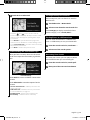
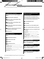
First Time Setup
These are the steps that you need to complete to
set up the system. These steps normally have to
be performed only once.
• Select a language.
• Select your current time zone.
• Select whether you want your system to auto-adjust for
daylight saving time.
• Select your preferred units of measure (statute or metric).
The first time you use your Kenwood Navigation System, you need to set up your system.
Getting Started
190-00901-00_0A.indd 9190-00901-00_0A.indd 9 1/23/2008 11:38:00 AM1/23/2008 11:38:00 AM

10 DNX5120/DNX512EX GPS Navigation Instruction Manual
Find It and Go!
Follow the instructions on the next two pages to find a place and go to it!
Finding a Restaurant
1 Touch Where To?.
2 Touch Food, Hotel….
3 Touch Food & Drink.
4 Touch a food category.
5 Touch a place.
6 Touch Go To.
190-00901-00_0A.indd 10190-00901-00_0A.indd 10 1/23/2008 11:38:00 AM1/23/2008 11:38:00 AM

English 11
Following Your Route
Follow the route to your destination using the
map. As you travel, the navigation system guides
you to your destination with voice prompts,
arrows, and directions along the top of the map.
If you depart from the original route, the
navigation system recalculates the route and
provides new route instructions.
Your route is marked with a highlighted line.
The default line color is green.
Follow the arrows.
A checkered flag marks your destination.
For more information about using the map and
the other tools, see pages 16-17.
190-00901-00_0A.indd 11190-00901-00_0A.indd 11 1/23/2008 11:38:01 AM1/23/2008 11:38:01 AM

12 DNX5120/DNX512EX GPS Navigation Instruction Manual
Finding an Address
1 From the Menu page, touch Where
To? > Address.
2 Select a state. Touch Search All Cities or
select a city.
3 Enter the address number and touch Done.
4 Enter the street name and touch Done.
5 Select the street. Select the city, if
necessary.
6 Select the address, if necessary. Touch
Go To.
Finding a Place Using the Map
1 From the Menu page, touch View Map.
You can also touch Where to? > Browse
Map. Touch anywhere on the map to
recenter the map on that location.
2 Touch any object on the map. Touch
Review.
Where To?
The Where To? menu provides several categories to help you quickly find your destination. Use the Where
To? menu to perform a simple search.
Next page 3
190-00901-00_0A.indd 12190-00901-00_0A.indd 12 1/23/2008 11:38:01 AM1/23/2008 11:38:01 AM

English 13
3 Touch Go To or Advanced.
• Touch the and icons to zoom in and out.
• Touch an object on the map. The map recenters on that
location, and an arrow appears, pointing at the object
you selected.
• Touch
Review to open the information page for the
location; for more information, see the following section.
• Touch
Save As Favorite to save the location selected by
the pointer to your Favorites.
• Touch
Back to return to the previous screen.
Understanding the Information Page
When you find a location, select it in the search
results list to open the information page for the
item.
Information Page
Touch Go To to create and follow a route to this
location.
Touch
Advanced to view other options for this
location:
• Insert in Current Route—add this point as the next
stop in your route.
•
Add As Favorite—add this location to your Favorites.
For more information, see page 14.
•
Find Near Point—find a location near this point.
•
Browse Map—view this location on the map.
Finding Recently Found Places
The last 50 places you have found are stored in
Recent Finds.
1 Touch Where To? > Recent Finds.
2 Select an item from the search results list.
Touch
Category to display recent finds from a
certain category, such as Food, Hotel….
Finding Places in a Different Area
You can search for locations in a different area,
such as a different city or near your destination.
1 From the search results list, touch Near….
2 Select one of the search options.
Narrowing Your Search
To narrow your search, you can spell part of the
name of the location you are searching for.
1 From the search results list, touch Spell.
2 Enter part of the name and touch Done.
190-00901-00_0A.indd 13190-00901-00_0A.indd 13 1/23/2008 11:38:02 AM1/23/2008 11:38:02 AM

14 DNX5120/DNX512EX GPS Navigation Instruction Manual
Saving Places You Find
After you have found a place you want to save,
select it from the results list.
1 Touch Advanced.
2 Touch Add As Favorite.
Saving Your Current Location
From the Menu page, touch View Map.
1 Touch anywhere on the map.
2 Touch Save As Favorite.
Setting a Home Location
You can set a Home Location for the place you
return to most often. From the Menu page, touch
Where To?.
1 Touch Go Home.
2 Select an option.
3 Touch Save Home.
After you set your Home Location, touch
Where
To? and then touch Go Home.
My Locations
You can save all of your favorite places in My Locations. You can also save your home location in My
Locations.
190-00901-00_0A.indd 14190-00901-00_0A.indd 14 1/23/2008 11:38:03 AM1/23/2008 11:38:03 AM

English 15
Finding Saved Places
From the Menu page, touch Where To?.
1 Touch My Locations.
2 Touch Favorites.
3 Touch a saved place.
Editing Saved Places
From the Menu page, touch Tools > My Data >
Favorites.
1 Touch Edit/Review Favorites.
2
Touch the item you want to edit.
3 Touch Edit.
4 Touch the item you want to edit.
• Name—enter a new name for the location using the on-
screen keyboard.
•
Location—edit the location of the place. You can use
the map or enter new coordinates using the keyboard.
•
Elevation—enter the elevation of the saved place.
•
Category—assign this place to a category. Touch
to view the categories.
• Symbol—select a symbol that is shown on the map for
this location.
Deleting a Saved Place
From the Menu page, touch Tool s > My Data >
Favorites.
1 Touch Delete Favorites.
2
Touch By Selection.
• By Selection—touch each location and delete it
individually.
• By Category—select one category to delete all of the
locations assigned to that category.
• Delete All—removes all saved places from your
Favorites.
3 Touch a saved location.
4 Touch Delete.
190-00901-00_0A.indd 15190-00901-00_0A.indd 15 1/23/2008 11:38:03 AM1/23/2008 11:38:03 AM

16 DNX5120/DNX512EX GPS Navigation Instruction Manual
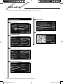
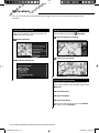
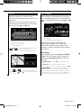
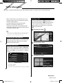
Viewing the Map Page
From the Menu page, touch View Map to
open the map. Touch an area of the map to see
additional information, as shown below. The
position icon shows your current location.
1 While navigating a route, touch the text bar
to open the Turn List. See
the next page.
2 Distance to the next turn.
3 Touch to zoom out.
4 Touch to zoom in.
5 Touch the map to view and browse a 2-D
map.
6 Touch the Speed or Arrival Time data field
to open the Trip Computer.
⁄
• A speed limit icon may appear as you travel on major
roadways. This icon displays the current speed limit of the
roadway.
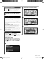
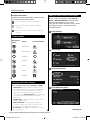
Trip Computer
The Trip Computer indicates your current speed
and provides helpful statistics about your trip.
To view the Trip Computer, select
Speed or
Arrival on the map. Or, from the Menu page,
touch To ol s > Trip Computer.
1 Current direction of travel
2 Current speed
3 Distance to your final destination
4 Total distance traveled (odometer)
5 Touch
Reset Trip to reset all information on
the Trip Computer.
6 To reset the Maximum Speed, touch Reset
Max.
1 2
3
4
5 6
1 2
3
4
5 6
The Map and Other Tools
This section provides details about the Map Page, the Trip Computer, the Turn List, and the GPS Info Page.
Map Page while Navigating a Route
1
2
3 4
5
6
6
190-00901-00_0A.indd 16190-00901-00_0A.indd 16 1/23/2008 11:38:03 AM1/23/2008 11:38:03 AM

English 17
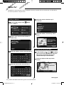
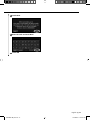
Turn List
The Turn List displays a list of turn-by-turn
instructions for your entire route, as well as arrival
information.
While navigating a route, touch the text bar on
the map page to open the Turn List. Or, from the
Menu page, touch
Tools > Turn List.
1 Direction of this turn
2 Distance to this turn
3 Turn directions
• Touch View All to see all the turns on the route. Touch
and to scroll through the list.
•
Touch a turn to see the turn on a map (the Next Turn
page).
•
Touch and to scroll through all the turns on
the route. Touch
and to zoom in and out of the
turn on the map.
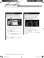
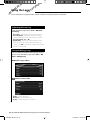
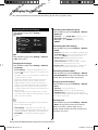
GPS Info Page
From the Menu page, touch the signal strength
bars in the upper left corner to view the GPS Info
page. Or, from the Menu page, touch
Tools > GPS
Info
.
1
2
1 Sky view
2 Satellite signal-strength bars
The sky view shows the satellites you are
receiving. The satellite signal-strength bars
indicate the strength of each satellite you are
receiving. A solid bar indicates the GPS satellite is
ready for use.
GPS Settings
From the Menu page, touch
Settings > General
> GPS. You can also access the GPS Settings by
touching the GPS Settings button on the GPS
Info page.
• Simulator Mode—touch Off to turn the GPS receiver
off.
• Set Position—set your position, if Use Indoors is
enabled. Select your location on the map and touch
OK.
• WAAS/ EGNOS—disable and enable WAAS/EGNOS.
WAAS and EGNOS are systems of satellites and ground
stations that provide GPS signal corrections, giving you
even better position accuracy. To learn about WAAS and
EGNOS, visit
www.garmin.com/aboutGPS/waas.html.
1
2
3
1
2
3
Next Turn Page
190-00901-00_0A.indd 17190-00901-00_0A.indd 17 1/23/2008 11:38:04 AM1/23/2008 11:38:04 AM

18 DNX5120/DNX512EX GPS Navigation Instruction Manual
Creating a New Saved Route
From the Menu page, touch Tools > My Data >
Routes.
1 Touch Create New Saved Route.
2 Select an option and touch Next. Select
the starting point.
3 Select an option and touch Next. Select
the ending point.
4 To add a stop, touch Ye s , then touch Next.
Select the point.
5 Select your sorting and route calculation
preferences and touch Next.
6 Touch Finish.
Editing a Saved Route
From the Menu page, touch Tools > My Data >
Routes.
1 Touch Edit/Review Routes.
2 Touch the route to edit.
3 Touch Edit.
4 Touch the item to edit.
• Rename—enter a new name for the route using the
on-screen keyboard.
•
Edit/Review Points—add, arrange, remove, reorder, and
review points in the route. For more information, see the
following section.
•
Change Preference—change your calculation
preference to Faster Time, Shorter Distance, or Off Road.
•
Delete Route—delete this route.
Adding an Intermediate Destination
Point to Your Route
You can add intermediate destination points
(stops) to your route as you create it. You can
also add points to your route when you edit the
route, as described below. Follow the steps in the
previous section to begin editing the route.
1 Touch Edit/Review Points.
2 Touch Add.
3 Touch where you want to add the point.
4 Touch a method and then select the point.
5 Add points as necessary. Touch Done when
finished.
• Auto Arrange—arranges the points to provide the
shortest route.
•
Remove—touch the point you want to remove and
then touch
Remove.
•
Re-Order—touch the point to move and touch Move
Up
or Move Down. Touch Done when finished.
• Review—allows you to view the information page for
any point along the route. For details on the information
page, see
page 13.
Saving the Active Route
From the Menu page, touch Tools > My Data >
Routes > Save Active Route.
Navigating a Saved Route
From the Menu page, touch Tools > My Data >
Routes > Navigate Saved Route. Touch the
route you want to navigate.
Recalculating the Route
From the Menu page, touch Tools > My Data >
Routes > Recalculate Route.
Creating and Editing Routes
This section describes how to create and customize your routes.
190-00901-00_0A.indd 18190-00901-00_0A.indd 18 1/23/2008 11:38:04 AM1/23/2008 11:38:04 AM

English 19
Deleting All Saved Routes
From the Menu page, touch Tools > My Data >
Routes > > Delete All Saved Routes.
Stopping Your Route
From the Menu page, touch Stop. Then touch
Ye s .
Adding a Detour to a Route
If you need to take a detour from your current
route, open the Menu page and touch Detour.
• 1/2 mile, 2 miles, or 5 miles—select the distance for
the detour. For example, if a road sign indicates that the
street is closed for the next 2 miles, touch
2 miles in the
list. The navigation system recalculates your route for the
next 2 miles.
•
Detour by Road(s) In Route—select roads on your
route to avoid. For example, if the highway ramp is
closed, select the ramp in the list of roads. The navigation
system recalculates your route to avoid that ramp.
•
Detour by Traffic Event on Route—if you are using an
FM Traffic Receiver, you can detour around traffic events.
•
Remove All Detours—touch to remove any detours
you have entered for the route.
Adding Avoidances
From the Menu page, touch Settings >
Navigation > > Avoidance Setup. Select
the road type to avoid. Touch
to view more
road types to avoid.
Creating Custom Avoids
You can enter specific areas and roads to avoid
on your routes. From the Avoidance Setup menu,
touch
two times and then touch Custom
Avoids.
1 Touch Add New Avoid Area or Add New
Avoid Road.
2 Touch the first corner and touch Next.
3 Touch the second corner and touch Next.
4 Touch Finish.
190-00901-00_0A.indd 19190-00901-00_0A.indd 19 1/23/2008 11:38:04 AM1/23/2008 11:38:04 AM

20 DNX5120/DNX512EX GPS Navigation Instruction Manual
Adjusting the Track Log
From the Menu page, touch Tools > My Data >
Track Log.
• Recording—turn the track log recorder on and off.
• Percentage Full—displays the current percentage
capacity of the track log. To clear the track log, touch
Percentage Full > Ye s > OK.
• Map Display—displays the current track log on the
map. Select a zoom setting at which the track log is
shown. Touch OK. Your track log is displayed as a narrow
dotted line on the map.
Using the Mileage Logs
You can keep four different mileage logs of your
travels. From the Menu page, touch Tools > My
Data > Mileage Log.
1 Touch a log to edit it.
2 Select an item to edit.
• Name—enter a new name.
• Distance— reset the mileage log.
• Active—make this log active or inactive.
Using the Logs
As you travel, the navigator creates a bread-crumb trail (track log) of your movement.
190-00901-00_0A.indd 20190-00901-00_0A.indd 20 1/23/2008 11:38:05 AM1/23/2008 11:38:05 AM
Page is loading ...
Page is loading ...
Page is loading ...
Page is loading ...
Page is loading ...
Page is loading ...
Page is loading ...
Page is loading ...
Page is loading ...
Page is loading ...
Page is loading ...
Page is loading ...
-
 1
1
-
 2
2
-
 3
3
-
 4
4
-
 5
5
-
 6
6
-
 7
7
-
 8
8
-
 9
9
-
 10
10
-
 11
11
-
 12
12
-
 13
13
-
 14
14
-
 15
15
-
 16
16
-
 17
17
-
 18
18
-
 19
19
-
 20
20
-
 21
21
-
 22
22
-
 23
23
-
 24
24
-
 25
25
-
 26
26
-
 27
27
-
 28
28
-
 29
29
-
 30
30
-
 31
31
-
 32
32


Kenwood DDX-512 - DVD Player With LCD monitor User manual
- Category
- Navigators
- Type
- User manual
- This manual is also suitable for
Ask a question and I''ll find the answer in the document
Finding information in a document is now easier with AI
Related papers
-
Kenwood DNX5080EX User manual
-
Kenwood DNN 9150 DAB GPS Navigation System User manual
-
-
-
Kenwood DNX891HD Navigation Manual
-
Kenwood DNX5250BT User manual
-
-
-
Kenwood DNX9980HD User manual
-
Other documents
-
Garmin Clear Channel End User License Agreement
-
Garmin fleet590 Quick start guide
-
-
-
Garmin GSN-002 (2703) User manual
-
Dodge Charger Owner's manual
-
Garmin GVN 52 Owner's manual
-
Dodge 2013 Grand Cherokee User manual
-
-
Dodge 2013 2500 User manual