
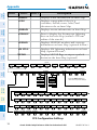
G1000
®
Integrated Flight Deck
Cockpit Reference Guide for the Beechcraft G36


FLIGHT INSTRUMENTS
ENGINE INDICATION SYSTEM
NAV/COM/TRANSPONDER/AUDIO PANEL
AUTOMATIC FLIGHT CONTROL SYSTEM
GPS NAVIGATION
FLIGHT PLANNING
PROCEDURES
HAZARD AVOIDANCE
ADDITIONAL FEATURES
ABNORMAL OPERATION
ANNUNCIATIONS & ALERTS
APPENDIX
INDEX


Copyright © 2007-2011, 2019 Garmin Ltd. or its subsidiaries. All rights reserved.
This manual reflects the operation of System Software version 0858.10 or later for the Beechcraft
G36 . Some differences in operation may be observed when comparing the information in this
manual to earlier or later software versions.
Garmin International, Inc.
1200 East 151st Street
Olathe, Kansas 66062, U.S.A.
Garmin (Europe) Ltd.
Liberty House, Hounsdown Business Park
Southampton, Hampshire SO40 9LR U.K.
Garmin AT, Inc.
2345 Turner Road SE
Salem, OR 97302, U.S.A.
Garmin Corporation
No. 68, Zhangshu 2nd Road
Xizhi District, New Taipei City, Taiwan
Contact Garmin Product Support or view warranty information at
www.flygarmin.com.
Except as expressly provided herein, no part of this manual may be reproduced, copied,
transmitted, disseminated, downloaded or stored in any storage medium, for any purpose
without the express written permission of Garmin. Garmin hereby grants permission to
download a single copy of this manual and of any revision to this manual onto a hard drive or
other electronic storage medium to be viewed for personal use, provided that such electronic
or printed copy of this manual or revision must contain the complete text of this copyright
notice and provided further that any unauthorized commercial distribution of this manual or any
revision hereto is strictly prohibited.
Garmin
®
is a registered trademark of Garmin Ltd. or its subsidiaries, and G1000
®
is a trademark
of Garmin Ltd. or its subsidiaries. These trademarks may not be used without the express
permission of Garmin.
Bendix/King
®
and Honeywell
®
are registered trademarks of Honeywell International, Inc.;
Becker
®
is a registered trademark of Becker Flugfunkwerk GmbH; NavData
®
is a registered
trademark of Jeppesen, Inc. SiriusXM Weather and SiriusXM Satellite Radio are provided by
SiriusXM Satellite Radio, Inc.

AOPA Membership Publications, Inc. and its related organizations (hereinafter collectively
“AOPA”) expressly disclaim all warranties, with respect to the AOPA information included in this
data, express or implied, including, but not limited to, the implied warranties of merchantability
and fitness for a particular purpose. The information is provided “as is” and AOPA does not
warrant or make any representations regarding its accuracy, reliability, or otherwise. Under
no circumstances including negligence, shall AOPA be liable for any incidental, special or
consequential damages that result from the use or inability to use the software or related
documentation, even if AOPA or an AOPA authorized representative has been advised of the
possibility of such damages. User agrees not to sue AOPA and, to the maximum extent allowed
by law, to release and hold harmless AOPA from any causes of action, claims or losses related
to any actual or alleged inaccuracies in the information. Some jurisdictions do not allow the
limitation or exclusion of implied warranties or liability for incidental or consequential damages
so the above limitations or exclusions may not apply to you.
AC-U-KWIK and its related organizations (hereafter collectively “AC-U-KWIK Organizations”)
expressly disclaim all warranties with respect to the AC-U-KWIK information included in this
data, express or implied, including, but not limited to, the implied warranties of merchantability
and fitness for a particular purpose. The information is provided “as is” and AC-U-KWIK
Organizations do not warrant or make any representations regarding its accuracy, reliability,
or otherwise. Licensee agrees not to sue AC-U-KWIK Organizations and, to the maximum
extent allowed by law, to release and hold harmless AC-U-KWIK Organizations from
any cause of action, claims or losses related to any actual or alleged inaccuracies in the
information arising out of Garmin’s use of the information in the datasets. Some jurisdictions
do not allow the limitation or exclusion of implied warranties or liability for incidental or
consequential damages so the above limitations or exclusions may not apply to licensee
Printed in the U.S.A

Garmin G1000 Cockpit Reference Guide for the Beechcraft G36
190-00525-05 Rev. B
Warnings, Cautions & Notes
WARNING: Do not use terrain avoidance displays as the sole source of infor-
mation for maintaining separation from terrain and obstacles. Garmin obtains
terrain and obstacle data from third party sources and cannot independently
verify the accuracy of the information.
WARNING: Always refer to current aeronautical charts and NOTAMs for
verification of displayed aeronautical information. Displayed aeronautical
data may not incorporate the latest NOTAM information.
WARNING: Do not use geometric altitude for compliance with air traffic
control altitude requirements. The primary barometric altimeter must be used
for compliance with all air traffic control altitude regulations, requirements,
instructions, and clearances.
WARNING: Do not use basemap information (land and water data) as the
sole means of navigation. Basemap data is intended only to supplement other
approved navigation data sources and should be considered only an aid to
enhance situational awareness.
WARNING: Do not rely solely upon the display of traffic information to
accurately depict all of the traffic within range of the aircraft. Due to lack
of equipment, poor signal reception, and/or inaccurate information from
aircraft or ground stations, traffic may be present that is not represented on
the display.
WARNING: Do not use data link weather information for maneuvering in,
near, or around areas of hazardous weather. Information contained within
data link weather products may not accurately depict current weather condi-
tions.
WARNING: Do not use the indicated data link weather product age to deter-
mine the age of the weather information shown by the data link weather
product. Due to time delays inherent in gathering and processing weather
data for data link transmission, the weather information shown by the data
link weather product may be older than the indicated weather product age.

Garmin G1000 Cockpit Reference Guide for the Beechcraft G36
190-00525-05 Rev. B
Warnings, Cautions & Notes
WARNING: The displayed minimum safe altitude (MSAs) are only advisory
in nature and should not be relied upon as the sole source of obstacle and
terrain avoidance information. Always refer to current aeronautical charts for
appropriate minimum clearance altitudes.
WARNING: Always obtain qualified instruction prior to operational use of
this equipment.
WARNING: Do not use GPS to navigate to any active waypoint identified as
a ‘NON WGS84 WPT’ by a system message. ‘NON WGS84 WPT’ waypoints
are derived from an unknown map reference datum that may be incompatible
with the map reference datum used by GPS (known as WGS84) and may be
positioned in error as displayed.
WARNING: Do not rely on the autopilot to level the aircraft at the MDA/DH
when flying an approach with vertical guidance. The autopilot will not level
the aircraft at the MDA/DH even if the MDA/DH is set in the altitude preselect.
WARNING: Do not rely solely upon the display of traffic information for col-
lision avoidance maneuvering. The traffic display does not provide collision
avoidance resolution advisories and does not under any circumstances or
conditions relieve the pilot’s responsibility to see and avoid other aircraft.
WARNING:
Use appropriate primary systems for navigation, and for terrain,
obstacle, and traffic avoidance. Garmin SVT is intended as an aid to situ-
ational awareness only and may not provide either the accuracy or reliability
upon which to solely base decisions and/or plan maneuvers to avoid terrain,
obstacles, or traffic.
WARNING:
Do not use the Garmin SVT runway depiction as the sole means
for determining the proximity of the aircraft to the runway or for maintaining
the proper approach path angle during landing.

Garmin G1000 Cockpit Reference Guide for the Beechcraft G36
190-00525-05 Rev. B
Warnings, Cautions & Notes
WARNING: Do not rely on information from a lightning detection system
display as the sole basis for hazardous weather avoidance. Range limitations
and interference may cause the system to display inaccurate or incomplete
information. Refer to documentation from the lightning detection system
manufacturer for detailed information about the system.
WARNING: Do not use TAWS information for primary terrain or obstacle
avoidance. TAWS is intended only to enhance situational awareness.
WARNING: Do not use a QFE altimeter setting with this system. System
functions will not operate properly with a QFE altimeter setting. Use only
a QNH altimeter setting for height above mean sea level, or the standard
pressure setting, as applicable.
CAUTION: Do not clean display surfaces with abrasive cloths or cleaners
containing ammonia. They will harm the anti-reflective coating.
C
AUTION:
Do not allow repairs to be made by anyone other than an authorized
Garmin service center. Unauthorized repairs or modifications could void both
the warranty and affect the airworthiness of the aircraft.
CAUTION: Never disconnect power to the system when loading a database.
Power interruption during the database loading process could result in
maintenance being required to reboot the system.
NOTE All visual depictions contained within this document, including screen
images of the system panel and displays, are subject to change and may not
reflect the most current system and aviation databases. Depictions of equip-
ment may differ slightly from the actual equipment.
NOTE: Do not rely solely upon data link services to provide Temporary Flight
Restriction (TFR) information. Always confirm TFR information through official
sources such as Flight Service Stations or Air Traffic Control.

Garmin G1000 Cockpit Reference Guide for the Beechcraft G36
190-00525-05 Rev. B
Warnings, Cautions & Notes
NOTE: The United States government operates the Global Positioning System
and is solely responsible for its accuracy and maintenance. The GPS system
is subject to changes which could affect the accuracy and performance of all
GPS equipment. Portions of the system utilize GPS as a precision electronic
NAVigation AID (NAVAID). Therefore, as with all NAVAIDs, information
presented by the system can be misused or misinterpreted and, therefore,
become unsafe.
NOTE
: This device complies with part 15 of the FCC Rules. Operation is
subject to the following two conditions: (1) this device may not cause harm-
ful interference, and (2) this device must accept any interference received,
including interference that may cause undesired operation.
NOTE
: Interference from GPS repeaters operating inside nearby hangars can
cause an intermittent loss of attitude and heading displays while the aircraft
is on the ground. Moving the aircraft more than 100 yards away from the
source of the interference should alleviate the condition.
NOTE
: Use of polarized eyewear may cause the flight displays to appear dim
or blank.
NOTE
: This product, its packaging, and its components contain chemicals
known to the State of California to cause cancer, birth defects, or reproductive
harm. This notice is being provided in accordance with California’s Proposition
65. If you have any questions or would like additional information, please
refer to our web site at www.garmin.com/prop65.
NOTE: Operating the system in the vicinity of metal buildings, metal struc-
tures, or electromagnetic fields can cause sensor differences that may result
in nuisance miscompare annunciations during start up, shut down, or while
taxiing. If one or more of the sensed values are unavailable, the annunciation
indicates no comparison is possible.

Garmin G1000 Cockpit Reference Guide for the Beechcraft G36
190-00525-05 Rev. B
Warnings, Cautions & Notes
NOTE: The system responds to a terminal procedure based on data coded
within that procedure in the Navigation Database. Differences in system
operation may be observed among similar types of procedures due to differ-
ences in the Navigation Database coding specific to each procedure.
NOTE: The FAA has asked Garmin to remind pilots who fly with Garmin
database-dependent avionics of the following:
• It is the pilot’s responsibility to remain familiar with all FAA regulatory and
advisory guidance and information related to the use of databases in the
National Airspace System.
• Garmin equipment will only recognize and use databases that are obtained
from Garmin or Jeppesen. Databases obtained from Garmin or Jeppesen
that have a Type 2 Letter of Authorization (LOA) from the FAA are assured
compliance with all data quality requirements (DQRs). A copy of the Type
2 LOA is available for each applicable database and can be viewed at
http://fly.garmin.com by selecting ‘Aviation Database Declarations.’
• Use of a current Garmin or Jeppesen database in your Garmin equipment
is required for compliance with established FAA regulatory guidance, but
does not constitute authorization to fly any and all terminal procedures
that may be presented by the system. It is the pilot’s responsibility to
operate in accordance with established pertinent aircraft documents and
regulatory guidance or limitations as applicable to the pilot, the aircraft,
and installed equipment.
NOTE
: The pilot/operator must review and be familiar with Garmin’s database
exclusion list as discussed in SAIB CE-14-04 to determine what data may be
incomplete. The database exclusion list can be viewed at www.flygarmin.
com by selecting ‘Database Exclusions List.’
NOTE
: The pilot/operator must have access to Garmin and Jeppesen data-
base alerts and consider their impact on the intended aircraft operation. The
database alerts can be viewed at www.flygarmin.com by selecting ‘Aviation
Database Alerts.’

Garmin G1000 Cockpit Reference Guide for the Beechcraft G36
190-00525-05 Rev. B
Warnings, Cautions & Notes
NOTE
: If the pilot/operator wants or needs to adjust the database, contact
Garmin Product Support.
NOTE: Garmin requests the flight crew report any observed discrepancies
related to database information. These discrepancies could come in the form
of an incorrect procedure; incorrectly identified terrain, obstacles and fixes; or
any other displayed item used for navigation or communication in the air or
on the ground. Go to FlyGarmin.com and select ‘Aviation Data Error Report’.
NOTE: Electronic aeronautical charts displayed on this system have been
shown to meet the guidance in AC 120-76D as a Type B Electronic Flight Bag
(EFB) for FliteCharts and ChartView. The accuracy of the charts is subject to
the chart data provider. Own-ship position on airport surface charts cannot be
guaranteed to meet the accuracy specified in AC 120-76D. Possible additional
requirements may make a secondary source of aeronautical charts, such as
traditional paper charts or an additional electronic display, necessary on the
aircraft and available to the pilot. If the secondary source of aeronautical
charts is a Portable Electronic Device (PED), its use must be consistent with
the guidance in AC 120-76D.
NOTE: The navigation databases used in Garmin navigation systems con-
tain Special Procedures. Prior to flying these procedures, pilots must have
specific FAA authorization, training, and possession of the corresponding
current, and legitimately-sourced chart (approach plate, etc.). Inclusion of
the Special Procedure in the navigation database DOES NOT imply specific
FAA authorization to fly the procedure.
NOTE
: Terrain and obstacle alerting is not available north of 89º North latitude
and south of 89º South latitude. This is due to limitations present within the
Terrain database and the system’s ability to process the data representing
the affected areas.
NOTE: The nose of the ‘own ship’ symbol represents the location of the air-
craft. The center of any traffic symbol represents the location of that traffic.
The traffic and own ship symbols are an abstract representation and do not
reflect the physical extent of the aircraft/traffic, and should not replace other
methods for identifying traffic.

Garmin G1000 Cockpit Reference Guide for the Beechcraft G36
190-00525-05 Rev. B
Warnings, Cautions & Notes
NOTE: Lamp(s) inside this product contain mercury (HG) and must be recycled
or disposed of according to local, state, or federal laws. For more informa-
tion, refer to our website at www.garmin.com/en-US/company/environment/
recycling
NOTE: When using Stormscope, there are several atmospheric phenomena in
addition to nearby thunderstorms that can cause isolated discharge points in
the strike display mode. However, clusters of two or more discharge points
in the strike display mode do indicate thunderstorm activity if these points
reappear after the screen has been cleared.
NOTE: Operate G1000 system power through at least one cycle in a period
of four days of continuous operation to avoid an autonomous system reboot.
NOTE: The purpose of this Cockpit Reference Guide is to provide the pilot a
resource with which to find operating instructions on the major features of
the system more easily. It is not intended to be a comprehensive operating
guide. Complete operating procedures for the system are found in the Pilot’s
Guide for this aircraft..

Garmin G1000 Cockpit Reference Guide for the Beechcraft G36
190-00525-05 Rev. B
Warnings, Cautions & Notes
Blank Page

Garmin G1000 Cockpit Reference Guide for the Beechcraft G36
190-00525-05 Rev. B
Software License Agreement
SOFTWARE LICENSE AGREEMENT
BY USING THE DEVICE, COMPONENT OR SYSTEM MANUFACTURED OR SOLD BY GARMIN
(“THE GARMIN PRODUCT”), YOU AGREE TO BE BOUND BY THE TERMS AND CONDITIONS
OF THE FOLLOWING SOFTWARE LICENSE AGREEMENT. PLEASE READ THIS AGREEMENT
CAREFULLY. Garmin Ltd. and its subsidiaries (“Garmin”) grants you a limited license to use the
software embedded in the Garmin Product (the “Software”) in binary executable form in the
normal operation of the Garmin Product. Title, ownership rights, and intellectual property rights
in and to the Software remain with Garmin and/or its third-party providers. You acknowledge
that the Software is the property of Garmin and/or its third-party providers and is protected
under the United States of America copyright laws and international copyright treaties. You
further acknowledge that the structure, organization, and code of the Software are valuable
trade secrets of Garmin and/or its third-party providers and that the Software in source code
form remains a valuable trade secret of Garmin and/or its third-party providers. You agree not
to reproduce, decompile, disassemble, modify, reverse assemble, reverse engineer, or reduce to
human readable form the Software or any part thereof or create any derivative works based on
the Software. You agree not to export or re-export the Software to any country in violation of
the export control laws of the United States of America.

Garmin G1000 Cockpit Reference Guide for the Beechcraft G36
190-00525-05 Rev. B
Software License Agreement
Blank Page

Garmin G1000 Cockpit Reference Guide for the Beechcraft G36
190-00525-05 Rev. B
RR-1
Record of Revisions
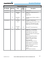
Record of Revisions
Part Number Revision Date
Page
Range
Description
190-00525-00 A August, 2005 All
Initial release.
190-00525-01 A
B
September,
2006
September,
2007
All
All
Added GDU software version 6.13
parameters.
Added TAWS
Changed system software number to
0464.08.
190-00525-02 A
B
December,
2007
December,
2007
All
All
Changed to smaller format
Added Airways, WAAS, VNAV & Charts
Updated G1000 System Messages
Added other GDU 8.10 parameters
Removed FD Formatting feature
190-00525-03 A July, 2010 All Added GDU 11.01 parameters
Added Synthetic Vision System
Added flight plan import/export
Updated procedure for entering User
Waypoints
Updated XM weather products
Updated TAWS annunciations
Added CDI operation in Dead
Reckoning mode
Added AOPA Airport Directory
Added temporary user waypoints
Added database synchronization
Added GTS 820 TAS
Removed support for non-WAAS
systems
Various clerical corrections

Garmin G1000 Cockpit Reference Guide for the Beechcraft G36
190-00525-05 Rev. B
RR-2
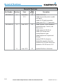
Record of Revisions
Record of Revisions
Part Number Revision Date
Page
Range
Description
190-00525-04 A September,
2011
All Added Profile View
Added new weather product symbols
and legend
Added MV DB update procedure
Added other GDU 11.12 parameters
190-00525-05 A June, 2019 All Added Software License Agreement
Updated Warnings, Cautions, and
Notes section
Added support for ADS-B out
Added User Defined Holds
Updated Approach types
Added Temperature Compensated
Altitudes
Updated TAWS-B information
Updated Transponder information
Updated Sirius XM radio information
Updated to GDU SW version13.31
B June, 2019 All Updated FliteCharts Information

Garmin G1000 Cockpit Reference Guide for the Beechcraft G36
190-00525-05 Rev. B
i
Table of Contents
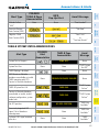
Flight Instruments ....................................................................................................................... 1
Selecting the Altimeter Barometric Pressure Setting ...................................................... 1
Selecting Standard Barometric Pressure (29.92 in Hg) .................................................... 1
Change Altimeter Barometric Pressure Setting Units ...................................................... 1
Change Navigation Sources ................................................................................................... 1
Enable/Disable OBS Mode While Navigating with GPS .................................................... 2
Generic Timer ............................................................................................................................. 2
Configure Vspeed Bugs Individually ..................................................................................... 2
Set Barometric Minimum Descent Altitude ........................................................................ 3
Displaying Wind Data .............................................................................................................. 3
Changing HSI Format ............................................................................................................... 3
Engine Indication System ........................................................................................................ 5
Engine Display ........................................................................................................................... 5
Lean Engine Display ................................................................................................................. 6
Engine System Display ............................................................................................................ 8
Nav/Com/Transponder/Audio Panel ................................................................................. 11
ADF Tuning (Optional) ............................................................................................................ 11
DME Tuning (Optional) ........................................................................................................... 11
Selecting A Transponder Mode ............................................................................................ 11
Enter a Transponder Code..................................................................................................... 11
Selecting a COM Radio .......................................................................................................... 12
Selecting a NAV Radio ........................................................................................................... 12
NAV/COM Tuning ..................................................................................................................... 12
Split COM .................................................................................................................................. 12
Digital Clearance Recorder and Player .............................................................................. 13
Intercom System (ICS) Isolation .......................................................................................... 13
Automatic Flight Control System ..................................................................................... 15
Flight Director Activation ..................................................................................................... 15
Vertical Modes ......................................................................................................................... 16
Lateral Modes .......................................................................................................................... 17
GPS Navigation ........................................................................................................................... 19
Direct-to Navigation .............................................................................................................. 19
Activate a Stored Flight Plan ............................................................................................... 20
Activate a Flight Plan Leg ..................................................................................................... 20
Stop Navigating a Flight Plan .............................................................................................. 21
Vertical Navigation (VNAV)................................................................................................... 21
Altitude Constraints ............................................................................................................... 22

Garmin G1000 Cockpit Reference Guide for the Beechcraft G36
190-00525-05 Rev. B
ii
Table of Contents
Flight Planning............................................................................................................................. 27
Trip Planning ............................................................................................................................ 27
Create a User Waypoint Defined by Latitude & Longitude ........................................... 29
Create a User Waypoint Defined by Radials from Other Waypoints ........................... 29
Create a User Waypoint Defined by a Radial & Distance from Another Waypoint .. 31
Delete a User Waypoint ......................................................................................................... 32
Create a Flight Plan ................................................................................................................ 33
Import a Flight Plan from an SD Card ................................................................................ 34
Insert a Waypoint in the Active Flight Plan ...................................................................... 35
Enter an Airway in a Flight Plan .......................................................................................... 35
Invert An Active Flight Plan .................................................................................................. 36
Entering An Along Track Offset Distance .......................................................................... 36
Remove a Departure, Arrival, Approach, or Airway from a Flight Plan ..................... 37
User Defined Holding Patterns ............................................................................................ 37
Activating Temperature Compensated Altitude .............................................................. 40
Cancelling Temperature Compensated Altitude .............................................................. 40
Store a Flight Plan .................................................................................................................. 41
Edit a Stored Flight Plan ....................................................................................................... 41
Delete a Waypoint from the Flight Plan ............................................................................ 41
Invert and Activate a Stored Flight Plan ........................................................................... 42
Copy a Flight Plan ................................................................................................................... 42
Delete a Flight Plan ................................................................................................................ 42
Graphical Flight Plan Creation ............................................................................................. 43
Export a Flight Plan to an SD Card ..................................................................................... 43
Procedures ..................................................................................................................................... 45
Load and Activate a Departure Procedure ....................................................................... 45
Activate A Departure Leg ..................................................................................................... 45
Load An Arrival Procedure .................................................................................................... 45
Activate An Arrival Leg ......................................................................................................... 46
Load and/or Activate an Approach Procedure ................................................................. 47
Approach Type and Downgrade Support .......................................................................... 48
Activate An Approach in the Active Flight Plan ............................................................... 48
Activate a Vector to Final Approach Fix ............................................................................ 48
Activate A Missed Approach in the Active Flight Plan ................................................... 49
Hazard Avoidance ...................................................................................................................... 51
Customizing the Hazard Displays on the Navigation Map ............................................ 51
STORMSCOPE® (Optional) .................................................................................................... 51
XM WX Satellite Weather (Subscription Optional) .......................................................... 53
Traffic Systems ........................................................................................................................ 55
Terrain Awareness & Warning System (TAWS-B) Display ............................................... 57
Page is loading ...
Page is loading ...
Page is loading ...
Page is loading ...
Page is loading ...
Page is loading ...
Page is loading ...
Page is loading ...
Page is loading ...
Page is loading ...
Page is loading ...
Page is loading ...
Page is loading ...
Page is loading ...
Page is loading ...
Page is loading ...
Page is loading ...
Page is loading ...
Page is loading ...
Page is loading ...
Page is loading ...
Page is loading ...
Page is loading ...
Page is loading ...
Page is loading ...
Page is loading ...
Page is loading ...
Page is loading ...
Page is loading ...
Page is loading ...
Page is loading ...
Page is loading ...
Page is loading ...
Page is loading ...
Page is loading ...
Page is loading ...
Page is loading ...
Page is loading ...
Page is loading ...
Page is loading ...
Page is loading ...
Page is loading ...
Page is loading ...
Page is loading ...
Page is loading ...
Page is loading ...
Page is loading ...
Page is loading ...
Page is loading ...
Page is loading ...
Page is loading ...
Page is loading ...
Page is loading ...
Page is loading ...
Page is loading ...
Page is loading ...
Page is loading ...
Page is loading ...
Page is loading ...
Page is loading ...
Page is loading ...
Page is loading ...
Page is loading ...
Page is loading ...
Page is loading ...
Page is loading ...
Page is loading ...
Page is loading ...
Page is loading ...
Page is loading ...
Page is loading ...
Page is loading ...
Page is loading ...
Page is loading ...
Page is loading ...
Page is loading ...
Page is loading ...
Page is loading ...
Page is loading ...
Page is loading ...
Page is loading ...
Page is loading ...
Page is loading ...
Page is loading ...
Page is loading ...
Page is loading ...
Page is loading ...
Page is loading ...
Page is loading ...
Page is loading ...
Page is loading ...
Page is loading ...
Page is loading ...
Page is loading ...
Page is loading ...
Page is loading ...
Page is loading ...
Page is loading ...
Page is loading ...
Page is loading ...
Page is loading ...
Page is loading ...
Page is loading ...
Page is loading ...
Page is loading ...
Page is loading ...
Page is loading ...
Page is loading ...
Page is loading ...
Page is loading ...
Page is loading ...
Page is loading ...
Page is loading ...
Page is loading ...
Page is loading ...
Page is loading ...
Page is loading ...
Page is loading ...
Page is loading ...
Page is loading ...
Page is loading ...
Page is loading ...
Page is loading ...
Page is loading ...
-
 1
1
-
 2
2
-
 3
3
-
 4
4
-
 5
5
-
 6
6
-
 7
7
-
 8
8
-
 9
9
-
 10
10
-
 11
11
-
 12
12
-
 13
13
-
 14
14
-
 15
15
-
 16
16
-
 17
17
-
 18
18
-
 19
19
-
 20
20
-
 21
21
-
 22
22
-
 23
23
-
 24
24
-
 25
25
-
 26
26
-
 27
27
-
 28
28
-
 29
29
-
 30
30
-
 31
31
-
 32
32
-
 33
33
-
 34
34
-
 35
35
-
 36
36
-
 37
37
-
 38
38
-
 39
39
-
 40
40
-
 41
41
-
 42
42
-
 43
43
-
 44
44
-
 45
45
-
 46
46
-
 47
47
-
 48
48
-
 49
49
-
 50
50
-
 51
51
-
 52
52
-
 53
53
-
 54
54
-
 55
55
-
 56
56
-
 57
57
-
 58
58
-
 59
59
-
 60
60
-
 61
61
-
 62
62
-
 63
63
-
 64
64
-
 65
65
-
 66
66
-
 67
67
-
 68
68
-
 69
69
-
 70
70
-
 71
71
-
 72
72
-
 73
73
-
 74
74
-
 75
75
-
 76
76
-
 77
77
-
 78
78
-
 79
79
-
 80
80
-
 81
81
-
 82
82
-
 83
83
-
 84
84
-
 85
85
-
 86
86
-
 87
87
-
 88
88
-
 89
89
-
 90
90
-
 91
91
-
 92
92
-
 93
93
-
 94
94
-
 95
95
-
 96
96
-
 97
97
-
 98
98
-
 99
99
-
 100
100
-
 101
101
-
 102
102
-
 103
103
-
 104
104
-
 105
105
-
 106
106
-
 107
107
-
 108
108
-
 109
109
-
 110
110
-
 111
111
-
 112
112
-
 113
113
-
 114
114
-
 115
115
-
 116
116
-
 117
117
-
 118
118
-
 119
119
-
 120
120
-
 121
121
-
 122
122
-
 123
123
-
 124
124
-
 125
125
-
 126
126
-
 127
127
-
 128
128
-
 129
129
-
 130
130
-
 131
131
-
 132
132
-
 133
133
-
 134
134
-
 135
135
-
 136
136
-
 137
137
-
 138
138
-
 139
139
-
 140
140
-
 141
141
-
 142
142
-
 143
143
-
 144
144


Garmin G1000: Beechcraft Bonanza A36/G36 Reference guide
- Type
- Reference guide
- This manual is also suitable for
Ask a question and I''ll find the answer in the document
Finding information in a document is now easier with AI
Related papers
-
Garmin G1000: Beechcraft Bonanza A36/G36 Reference guide
-
-
-
-
-
-
-
-
Garmin Cessna Caravan G1000 Reference guide
-