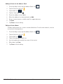
Magellan RC-9485T Operating instructions
- Category
- Navigators
- Type
- Operating instructions
This manual is also suitable for

Magellan RoadMate
RC9485T-LMB
User Manual

RC9485T-LMB User Manual ii www.magellangps.com
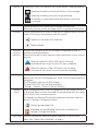
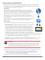
IMPORTANT SAFETY WARNINGS
The Magellan RoadMate receiver is a vehicle-navigation aid designed to assist you in arriving at
your selected destinations. When using the Magellan RoadMate receiver, these safety rules must
be followed to prevent accidents that can result in injury or death to yourself or others:
Please check the applicable regulations in your state regarding windshield mounting. Certain
states prohibit the mounting of any items on your windshield. Go to www.magellanGPS.com for
alternative mounting solutions.
When driving, the need to view the display is minimal. Voice prompts will guide you to your
destination. The driver should enter data or program the Magellan RoadMate receiver only when
the vehicle is stationary. Only a vehicle passenger should enter data or program the Magellan
RoadMate receiver while the vehicle is moving. Do not become distracted by the receiver while
driving, and always be fully aware of all driving conditions.
It is your responsibility to comply with all traffic laws and to use the Magellan RoadMate and
mounting options in such a manner that the user is in compliance with applicable laws.
Roads, points of interest (POIs), business and service locations may change over time. As a result
the database may contain inaccuracies.
The database does not include, analyze, process, consider, or reflect any of the following:
population density; neighborhood quality or safety; availability or proximity of police, emergency
rescue, medical or other assistance; construction work zones or hazards; road or lane closures;
pavement characteristics or conditions; special events. Roads, points of interest (POIs), business
and service locations may change over time. As a result the database may contain inaccuracies.
Certain Magellan devices (such as GPS for trucks and RVs) analyze and process certain legal
restrictions (such as vehicular type, weight, height, width, load and speed restrictions; road slope
or grade; bridge height, width, weight, or other limits). If your device offers this option, you must
make sure that you correctly configure your vehicle profile. When available on your device, these
legal restrictions are provided for your convenience only and it remains your responsibility to
disregard any unsafe, hazardous or illegal route suggestions.
Keep the Magellan RoadMate receiver safe from extreme temperature conditions. For example,
do not leave it exposed to direct sunlight for an extended period of time.
Take care when mounting the Magellan RoadMate receiver in your vehicle, whether using
the windshield mount or other mounts, that it does not obstruct the driver’s view of the road,
interfere with the operation of the vehicle’s safety devices such as air bags, or present a hazard to
occupants of the vehicle should the receiver be dislodged while driving. It is your responsibility to
assess the risks associated with damage to your vehicle or vehicle occupants as the result of your
choices in mounting the Magellan RoadMate receiver.
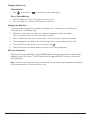
Temperature
The maximum operating temperature is 140°F (60°C).
Battery
The battery in the Magellan RoadMate receiver is rechargeable and should not be removed. In the
event that it should need to be replaced, please contact Magellan Technical Support.
Charging the Magellan RoadMate
An optional AC adapter is available as an accessory for your Magellan RoadMate . Use of another
type of AC adapter can result in malfunction and/or possible fire hazard due to battery overheating.

RC9485T-LMB User Manual iii www.magellangps.com
Only use the car charger approved for/supplied with your Magellan RoadMate receiver. Use of
another type of car charger may result in fire or electric shock.
For safety reasons, the battery in your Magellan RoadMate receiver will stop charging when the
ambient temperature is less than 32°F (0°C) or more than 113°F (45°C).
It will take approximately 4 hours of charging the Magellan RoadMate receiver through the vehicle
power adapter or optional AC adapter to obtain a full battery charge. It is recommended that you
charge the battery initially for at least 2 hours.
Use only the charger approved for your Magellan RoadMate receiver.
Estimated usage of the Magellan RoadMate on battery power is approximately 30 minutes.
Federal Communication Commission Interference Statement
This equipment has been tested and found to comply with the limits for class B digital devices,
in accordance with part 15 of the FCC Rules. These limits are designed to provide reasonable
protection against harmful interference in a residential installation. This equipment generates,
uses and can radiate radio frequency energy and, if not installed and used in accordance with
the instructions, may cause harmful interference to radio communications. However, there is
no guarantee that interference will not occur in a particular installation. If this equipment does
cause harmful interference to radio or television reception, which can be determined by turning
the equipment off and on, the user is encouraged to try to correct the interference by one of the
following measures:
Reorient or relocate the receiving antenna.
Increase the separation between the equipment and receiver.
Connect the equipment into an outlet on a circuit different from that to which the receiver is
connected.
Consult the dealer or an experienced radio/TV technician for help.
This device complies with Part 15 of the FCC Rules. Operation is subject to the following two
conditions: (1) This device may not cause harmful interference, and (2) this device must accept
any interference received, including interference that may cause undesired operation.
FCC Caution: Any changes or modifications not expressly approved by the party responsible for
compliance could void the user’s authority to operate this equipment.
IMPORTANT NOTE:
FCC Radiation Exposure Statement:
This equipment complies with FCC radiation exposure limits set forth for an uncontrolled
environment. End users must follow the specific operating instructions for satisfying RF exposure
compliance.
This transmitter must not be co-located or operating in conjunction with any other antenna or
transmitter.
In order to maintain compliance with FCC regulations, shielded cables must be used with this
equipment. Operation with non-approved equipment or unshielded cables is likely to result in
interference to radio and TV reception. The user is cautioned that changes and modifications
made to the equipment without the approval of manufacturer could void the user’s authority to
operate this equipment.

RC9485T-LMB User Manual iv www.magellangps.com
The Magellan RoadMate receiver must be installed and operated at a distance no closer than 8
inches (20 cm) from the user.
For body-worn operation, this device has been tested and meets FCC RF exposure guidelines that
positions the EUT a minimum of 8 inches (20 cm) from the body.
SAR Information: 0.009 W/kg (1g)
This Class B digital apparatus meets all requirements of the Canadian Interference-Causing
Equipment Regulations.
IC statement
Operation is subject to the following two conditions:
1. This device may not cause interference and
2. This device must accept any interference, including interference that may cause undesired
operation of the device.
IMPORTANT NOTE:
IC Radiation Exposure Statement:
This equipment complies with IC radiation exposure limits established for an uncontrolled
environment. End users must follow the specific operating instructions for satisfying RF exposure
compliance.
This transmitter must not be co-located or operated in conjunction with any other antenna or
transmitter.
Lifetime Traffic is for the lifetime of the GPS Device or until Magellan no longer receives relevant
traffic data whichever is shorter. Lifetime Traffic may not be transferred to another Magellan
device and may not be available in certain areas.
Lifetime Map Updates entitles you to receive up to four map updates per year for the lifetime of the
GPS Device or until Magellan no longer receives relevant map data, whichever is shorter. Lifetime
Map Update may not be transferred to another Magellan device. Internet connection required.
The information provided in this document is subject to change without notice. Improvements and
enhancements to the product may occur without any formal notification.

RC9485T-LMB User Manual v www.magellangps.com
© 2015 MiTAC International Corporation. The Magellan logo, Magellan, RoadMate and Quickspell
are registered trademarks of MiTAC International Corporation. SmartDetour and OneTouch
are trademarks of MiTAC International Corporation and are used under license by MiTAC
International Corporation. All rights reserved.
All other products and brand names are trademarks of their respective holders.
No part of this user manual may be reproduced or transmitted in any form or by any means,
electronic or mechanical, including photocopying and recording, for any purpose other than
the purchaser’s personal use, without the prior written permission of MiTAC International
Corporation.
MiTAC International Corporation assumes no responsibility or liability for any errors or
inaccuracies that may appear in the contents of this User Manual.
112-0082-001 A

RC9485T-LMB User Manual vi www.magellangps.com
Table of Contents
IMPORTANT SAFETY WARNINGS...............................ii
Fundamentals ..............................................1
Elements of the Map Screen 2
Install Cradle 5
Starting Up 5
Adjustments 6
My Places ..................................................9
OneTouch .................................................15
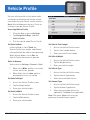
Vehicle Profile .............................................17
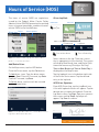
Hours of Service (HOS) ......................................18
International Fuel Tax Agreement (IFTA).......................21
Keyboard..................................................22
Magellan RoadMate Content .................................24
Syncing Content from SmartGPS Eco 25
Map Updates 26
Syncing to SmartGPS Eco with Wi-Fi 26
Routing . . . . . . . . . . . . . . . . . . . . . . . . . . . . . . . . . . . . . . . . . . . . . . . . . . .30
Bluetooth .................................................37
Settings...................................................42

Connect with us
@MagellanGPS
This user manual will give you the necessary
information on how to use the various features of the
Magellan RoadMate Commercial receiver.
Visit us at magellanGPS.com/support
MiTAC Digital Corporation
471 El Camino Real, Santa Clara, CA 95050 USA
www.magellanGPS.com

1
Chapter
RC9485T-LMB User Manual 1 www.magellangps.com
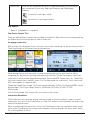
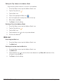
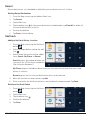
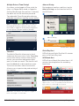
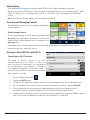
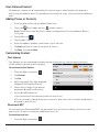
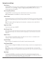
The Map Screen will be the most commonly used screen for driving and navigating to a
destination. The following will familiarize you with the icons and buttons on the device.
Data field
OneTouch Address Book Dial pad Settings
Battery
Time Wi-Fi
Bluetooth
Volume
Zoom In/Out
Slide Tile
to left
Slide Tile
to right
Vehicle
Square Tiles
Go To/My Route
SmartFind
Cancel route
Next Maneuver
Traffic Signal
AV inAudio
Home
Power ON/OFF
MicroSD
USB
Fundamentals

RC9485T-LMB User Manual 2 www.magellangps.com
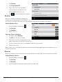
Elements of the Map Screen
Map Screen Header Bar
Time
Time is transmitted from the GPS satellites using an atomic clock as
reference. The Magellan RoadMate factors in the time zone for your
location as well as daylight savings time conditions to compute the local
time displayed. There are no settings for the time displayed.
Wi-Fi
Displays the current status of the Wi-Fi signal being received. Wi-Fi is
used to sync the device with SmartGPS Eco for content information.
Wi-Fi can be turned on or off as well as connect to a network in
Settings.
Wi-Fi is turned on in Settings and is connected to a Wi-Fi
network. The number of bars displayed (0-4) indicate the
received signal strength of Wi-Fi. Four white bars being the
strongest signal strength.
Wi-Fi is turned on in Settings but is not connected to any Wi-Fi
network.
Wi-Fi is turned off in Settings.
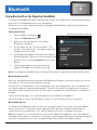
Bluetooth Displays the current pairing status of the Bluetooth connection. When
paired to a phone, the Magellan RoadMate receiver can be used as a
remote interface for your phone.
Bluetooth is paired to a phone.
Bluetooth is not paired to a phone.
Traffic
Signal
Status
This reports status of traffic reception from broadcast traffic or
(optional subscription) Internet Traffic.
For broadcast traffic, you must be in an area where traffic signals
are being transmitted and you must be using a Magellan-approved
vehicle power adapter. For Internet traffic, you must have purchased a
subscription and have an active Internet/data connection.
When the Magellan RoadMate receiver is turned on, it may take a
minute or more before any traffic information is displayed.
Traffic information is being received.
No traffic information is being received.
Subscription traffic is being received (paid)
Vehicle
Profile
When the RV icon is shown, routing will take vehicle profile into account,
such as weight, length, and width.

RC9485T-LMB User Manual 3 www.magellangps.com
Battery The battery status icon indicates the current battery charging condition.
Operating on battery, the internal battery is fully charged.
Operating on battery, with half charge remaining.
The battery is connected to an external power source and
is charging.
Zoom Level
Tap the + (zoom in) or - (zoom out) to change the map scale.
Alternately, you can use the two finger ‘pinch or spread’ to Zoom In/Out.
Volume Tap the Volume button to reveal a slider bar for volume control. Set the
slider all the way to the bottom to mute the sound.
Speaker On. Volume set by slider bar.
Speaker Muted.
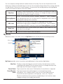
Current
Location
Indicator
Displays the current location of the Magellan RoadMate receiver in
relation to the displayed map.
Tap on the Current Location Indicator to get information on your current
location.
When the indicator is Blue, GPS signals are being
received and the current location has been computed.
When the indicator is Red, GPS signals are not being
received and the current location cannot be computed.
POI Icons
The Magellan RoadMate receiver uses various POI icons to graphically
display POIs for your surrounding area. Some of those are pointed out in
the graphic.
The POI graphic indicates the POI category.
To select which POI Icons are displayed, go to
‘Settings > Content > Points of Interest Visibility’.
Speed
Limits
While traveling on major roads the speed limit for the road you are on
is displayed. When you have exceeded the posted speed limit, the speed
limit icon will have a red warning halo.
The Speed Limit Warning Threshold for highways and other roads can
be set in ‘Settings > Navigation & Maps’.
Current posted speed limit.
Exceeding the posted speed limit by the threshold set in
Settings > Navigation & Maps.
Data Field
Contains information about your speed, elevation, or certain other
items. See “Types of Data Available” on page 6.

RC9485T-LMB User Manual 4 www.magellangps.com
Alert Icons There are two standard alerts that can be displayed on the screen when
they are present in your area, Red Light Cameras and Fixed Speed
Cameras.
Location of a red light camera.
Location of a fixed speed camera.
Map Updates
Refer to “Map Updates” on page 26.
Map Screen Content Tiles
There are eight different content tiles available on the device. When fewer tiles are displayed, tap
the Slide arrow (on the footer bar) to view all eight tiles.
Arranging content tiles
With all eight tiles displayed, touch a tile until it turns dark, then drag it to the position you want it.
The tile you drag it to will move to the vacated position.
While driving without an active route, the map can display by itself or with four tiles. While
navigating to a destination, the map can display with two tiles. The top tile displays traffic and
safety alerts, which include Yellow Warning signs, PhantomALERT, Amber Alert, etc. The bottom
tile shows content alerts and HOS states. If in Full Map mode (no visible tiles), Traffic Alerts and
HOS status appear as separate tabs.
The default (eight) tiles include: (1) Current street/maneuver, (2) Fuel, (3) PhantomALERT, Yellow
Warning Signs, Toll Plazas, Weigh Stations, (4) Weather, (5) Traffic, (6) HOS, (7) IFTA,
(8) Messages.
In Free Driving mode, four content tiles are shown on the screen.
Information Dashboard
The Dashboard screen provides driving information and instructions without a map or content
information. You can use the Home button or ‘Slide Tile’ button to switch between the map screen
and the Dashboard screen.
When a multiple-destination route is active, two Dashboard screens are available (current route/
entire route). One displays the current route segment, the other displays the entire route. Swipe
the screen up/down to select.

RC9485T-LMB User Manual 5 www.magellangps.com
Map Screen Footer Bar
Go To/My Route
SmartFind
Go To: Tap to use the keyboard and search a POI or address. Searched
items can be used as a destination or saved to the address book.
My Route: Displayed while routing. Tap to view information about the
route and for tools to delete, pause, or revise the route.
OneTouch
™
Access the OneTouch menu providing easy access to saved
destinations.
Address Book
Tap to access your address book. It contains saved addresses,
contacts, trips, and recent destinations.
You can use any or those as a destination.
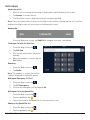
Dial Pad
Tap to bring up phone functions and access to Bluetooth settings.
Settings Tap to access setting options for the Magellan RoadMate receiver.
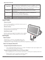
Install Cradle
Choose a location
Follow the Safety guidelines, and find a location in your car
with a clear view of the sky.
Clean the surface
Clean the area on the windshield where the device will be
mounted. Allow the surface to dry.
Install the car cradle
Hold the cradle firmly against the window surface and push
lever towards the base. Snap the device on to the cradle.
Starting Up
Connect power
The device has an internal, rechargeable battery that
charges whenever it is connected to vehicle power or a
compatible wall charger. Your device may not be fully charged when you purchase it.
Power On, Suspend, Power Off
Turning the Magellan RoadMate Receiver On
1. Press and hold the Power button for 2-3 seconds. The Magellan logo may not appear until a
few seconds after you release the button.
Turning the Magellan RoadMate Receiver Off (Suspend Mode)
If you suspend operation, the route and all information is held so you can quickly resume use.
1. Remove power or press and release the Power button.
A confirmation with countdown timer will appear.

RC9485T-LMB User Manual 6 www.magellangps.com
Tap Cancel to continue operation, otherwise the unit will suspend operation.
2. To resume, press and release the power button.
Turning the Magellan RoadMate Receiver Off (Shutdown)
1. Press and hold the Power button for 2-3 seconds and release when the Shutting Down
message is displayed.
The receiver will power off. This clears any inputs in progress, but does not cancel an active
route.
Adjustments
Adjusting the Volume
1. Tap the Volume icon.
2. Move the Volume slider to the desired level.
Muting the Volume
1. Tap the Volume icon.
2. Move the Volume slider to the bottom of the scale.
Changing the Data Field
The data field is shown on the Map screen.
1. Tap on the data field.
2. Select the desired data type from the list displayed.
Types of Data Available
Not Routing
Heading
Speed
Elevation
Routing
Estimated Time of Arrival
Amount of Time Remaining to Arrive at Destination
Total Distance Remaining
Heading
Speed
Elevation

RC9485T-LMB User Manual 7 www.magellangps.com
Changing Zoom Levels
Button Method
1. Tap to zoom in or to zoom out of the map display.
Pinch / Spread Method
1. Use two fingers to “Pinch” the map area to zoom out.
2. Use two fingers to “Spread” the map area to zoom in.
Changing the Map Style
The map can be changed to be viewed in 3-dimensional, 2-dimensional - North up or
2-dimensional - heading up style.
1. Swipe the screen over the map area, and the map options footer will appear.
This also appears when you use two fingers to zoom.
2. Select the desired style from the footer bar. (The active style is shown in Orange.)
3. The map updates according to the selected style. You can pan and zoom if you like.
4. To re-center the map on your current location, tap
5. Tap Close or press the Home button to return to the usual map footer.
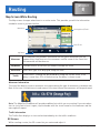
HOV Lane Preference
Optimize the route and ETA by using the HOV Lane feature when meeting the requirements
needed to travel HOV lanes. The HOV button can be toggled ON/OFF from any screen with
Routing Options.
Note: The device will notify with the exit maneuver alarm sooner than standard routing when
HOV Lane preference is selected for the route.

RC9485T-LMB User Manual 8 www.magellangps.com
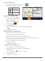
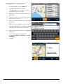
Viewing Current Location Details
1. Tap on the current location icon .
2. The Current Location screen is
displayed.
Saving Current Location
1. Tap on the current location icon .
2. The Current Location screen is
displayed.
3. Tap on the Save icon .
4. Select where to save the location (Wish
List, My Places or OneTouch).
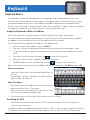
5. Use the keyboard to enter a name for
the location.
6. Tap Save.
7. Press the back arrow or the Home
button to return to the Map screen.

2
Chapter
RC9485T-LMB User Manual 9 www.magellangps.com
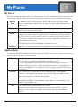
My Places
My Places can be best described as the place where all of the saved destinations and routes are
stored. There are four separate sections to My Places, each one with its own distinct purpose.
Address
Book
The Address Book stores contacts, places and trips that you have saved.
These can be used as destinations in a route or accessed using Bluetooth to
place a call.
Wish List
The Wish List are those places you found interesting and thought that you
might want to go to at some point.
Recent
Anytime you create a route, the destination is saved into your Recent places
list. This makes it easy to create a route to some place you routed to before.
* The route is saved to Recent when you create it, regardless of whether you
actually drove there or not.
** The Recent list will hold hundreds of previous routes.
OneTouch OneTouch is a customizable menu to hold destinations that you regularly use.
Address Book
The Address Book can hold places, contacts and trips. These are all user-entered and can easily
be accessed at any time to create a route.
Places
Each place has a name and stores only one address.
Once stored, the name can be edited but the address can’t.
Places is designed to hold locations that you commonly go to or need to
reference while driving. This could be anything from your local Starbucks to
a historical landmark. Think of places as your own personalized POIs (points
of interest).
Contacts
Each contact has a name and can store multiple places and numbers.
Contacts can be people, businesses, or any other thing that needs to have
more than one piece of information attached.
Each contact can have one or more addresses and can also have one or
more phone numbers. These might be home address, home number, work
address, work number, etc.
Trips
Trips contain one or several places as a route.
You can create a trip (route) in advance or save a route while it is active.
When you save a route, it includes the end point and any intermediate
points.
My Places

RC9485T-LMB User Manual 10 www.magellangps.com
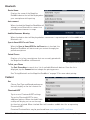
Accessing the Address Book
1. From the Map screen, tap the Address Book icon .
Three tabs are available, as below:
Places tab
Contacts Tab
Trips Tab
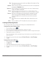
Adding a Place to the Address Book
1. From the Map screen, tap Go To...
2. You can select a POI or search an
address, as appropriate.
3. Select the POI or address to add.
4. Tap the Menu icon .
5. Tap Save to My Places.
6. Enter a name for the place or accept the default name displayed.
7. Tap Save.
8. Tap Done to finish editing.
Editing a Place Name in the Address Book
Only the descriptive name for a place can be edited.
1. From the Map screen, tap the Address Book icon.
2. Make sure that you are in the Places tab of the Address Book.
3. Tap the Edit icon, The place names then displays the item edit and item delete icons.
4. Tap on the Edit icon to the right of the place name.
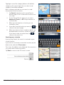
5. Use the keyboard to modify the name of the place.
6. When done, tap Save.
7. Tap Done to finish editing.
Deleting a Place from the Address Book
1. From the Map screen, tap the Address Book icon.
2. Make sure that you are in the Places tab of the Address Book.
3. Tap the Edit icon.
4. Tap the item delete icon for the place to be deleted.
5. Confirm the deletion.
6. Tap Done to finish editing.

RC9485T-LMB User Manual 11 www.magellangps.com
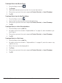
Adding a Contact to the Address Book
1. From the Map screen, tap the Address Book icon .
2. Tap the Contacts tab icon .
3. Tap the Edit icon .
4. Tap the “item add” icon .
5. Enter the address to be added.
6. When the address has been entered, tap Add.
7. Enter a contact name, or edit/accept the suggested name.
8. Tap Save.
9. Tap Done to finish editing.
Editing a Contact Name
The descriptive name for a contact can be edited here: To edit contact details, see the
instructions following these.
1. From the Map screen, tap the Address Book icon .
2. Tap the Contacts tab icon .
3. Tap the Edit icon .
4. Tap on the appropriate Edit icon
5. Use the keyboard to modify the name of the contact.
6. When done, tap Save.
7. Tap Done to finish editing.

RC9485T-LMB User Manual 12 www.magellangps.com
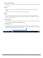
Editing Contact information
You can add, rename, or delete any phone number or place belonging to a contact.
In addition, you can edit any phone number for a contact. To do any of these operations, you
start by selecting the contact:
Selecting a contact to edit it
1. From the Map screen, tap the Address Book icon.
2. Tap the Contacts tab icon .
3. Select the contact to edit by tapping it.
4. The contact details will be listed - Tap the Edit icon.
Editing the name of a contact place
1. Once you tap the Edit icon, the Item Delete and Item Edit icons are displayed on each
contact place or number.
2. Tap the Item Edit icon on the detail to edit.
3. The keyboard is displayed so you can edit the display name.
4. Tap Save to return to the Contact Edit page.
5. Tap Done when finished editing.
Editing a contact number
1. Once you tap the Edit icon, the Item Delete and Item Edit icons are displayed on each
contact place or number.
2. Tap the Item Edit icon on the number to edit.
3. The numeric keyboard is displayed so you can edit the number.
4. Tap Done and the keyboard is displayed so you can edit the display name.
5. Tap Save to save changes and return to the Contact Edit page.
6. Tap Done when finished editing.
Adding a contact phone number
1. Once you tap the Edit icon, the Item Delete and Item Edit icons are displayed on each
contact place or number.
2. At the bottom header, the buttons + Address and + Phone are displayed.
3. Tap the + Phone button.
4. The numeric keyboard is displayed so you can input the number.
5. Tap Done and the keyboard is displayed so you can input the display name.
6. Tap Save to save changes and return to the Contact Edit page.
7. Tap Done when finished editing.
Adding a contact place
1. Once you tap the Edit icon, the Item Delete and Item Edit icons are displayed on each
contact place or number.

RC9485T-LMB User Manual 13 www.magellangps.com
2. At the bottom header, the buttons + Address and + Phone are displayed.
3. Tap the + Address button.
4. The full keyboard with POIs is displayed.
5. Locate the place to add. The full address/POI search is available.
6. Tap Done and the keyboard is displayed so you can edit the display name.
7. Tap Save to save changes and return to the Contact Edit page.
8. Tap Done when finished editing.
Deleting a Contact in the Address Book
This is to delete the entire contact. If you just want to remove or change details of the contact,
see the instructions previous.
1. From the Map screen, tap the Address Book icon.
2. Tap the Contacts tab icon .
3. Tap the Edit icon.
4. Tap the delete icon for the contact to be deleted.
5. Confirm the deletion.
6. Tap Done to finish editing.
Adding a Trip to the Address Book
1. From the Map screen, tap the Address Book icon.
2. Tap the Trip tab icon .
3. Tap the Edit icon.
4. Tap the button to add a new trip.
5. Create a trip (see
Routes
) to be added.
6. When the trip has been entered, tap Save.
7. Enter a name for the trip.
8. Tap Save.
9. Tap Done to finish editing.
Page is loading ...
Page is loading ...
Page is loading ...
Page is loading ...
Page is loading ...
Page is loading ...
Page is loading ...
Page is loading ...
Page is loading ...
Page is loading ...
Page is loading ...
Page is loading ...
Page is loading ...
Page is loading ...
Page is loading ...
Page is loading ...
Page is loading ...
Page is loading ...
Page is loading ...
Page is loading ...
Page is loading ...
Page is loading ...
Page is loading ...
Page is loading ...
Page is loading ...
Page is loading ...
Page is loading ...
Page is loading ...
Page is loading ...
Page is loading ...
Page is loading ...
Page is loading ...
Page is loading ...
Page is loading ...
Page is loading ...
Page is loading ...
-
 1
1
-
 2
2
-
 3
3
-
 4
4
-
 5
5
-
 6
6
-
 7
7
-
 8
8
-
 9
9
-
 10
10
-
 11
11
-
 12
12
-
 13
13
-
 14
14
-
 15
15
-
 16
16
-
 17
17
-
 18
18
-
 19
19
-
 20
20
-
 21
21
-
 22
22
-
 23
23
-
 24
24
-
 25
25
-
 26
26
-
 27
27
-
 28
28
-
 29
29
-
 30
30
-
 31
31
-
 32
32
-
 33
33
-
 34
34
-
 35
35
-
 36
36
-
 37
37
-
 38
38
-
 39
39
-
 40
40
-
 41
41
-
 42
42
-
 43
43
-
 44
44
-
 45
45
-
 46
46
-
 47
47
-
 48
48
-
 49
49
-
 50
50
-
 51
51
-
 52
52
-
 53
53
-
 54
54
-
 55
55
-
 56
56


Magellan RC-9485T Operating instructions
- Category
- Navigators
- Type
- Operating instructions
- This manual is also suitable for
Ask a question and I''ll find the answer in the document
Finding information in a document is now easier with AI
Related papers
-
Magellan Roadmate Commercial RC9496T-LMB User manual
-
-
Magellan Roadmate 5175 User manual
-
-
-
Mitac International P4Q-N538-5000 User manual
-
-
-
-
Other documents
-
MiTAC Magellan RoadMate 3065 Commuter User Handbook Manual
-
Prestigio GeoVision 5500 Navitel Owner's manual
-
iConnect .eTracELD LMU4230H User manual
-
 Sunwoda SWD-007 User manual
-
Columbia Magellan MX User manual
-
 PC*Miler 450 Quick Manual
-
ARRI LMB 4x5 User manual
-
 Magellan GPS Magellan HOS Compliance MGNHOS001 User manual
-
 Scanstrut LMB-F1 User manual
-
Lexmark Version 3.0 User manual


