Garmin DriveTrack 70 Owner's manual

Category
Car navigation systems
Type
Owner's manual

This manual is also suitable for

Garmin DriveTrack
70
Owner’s Manual
May 2016 190-02080-00_0A
All rights reserved. Under the copyright laws, this manual may not be copied, in whole or in part, without the written consent of Garmin. Garmin reserves the
right to change or improve its products and to make changes in the content of this manual without obligation to notify any person or organization of such
changes or improvements. Go to www.garmin.com for current updates and supplemental information concerning the use of this product.
Garmin
®
and the Garmin logo are trademarks of Garmin Ltd. or its subsidiaries, registered in the USA and other countries. These trademarks may not be used
without the express permission of Garmin.
Garmin DriveTrack
, Garmin Express
, myTrends
, nüMaps Guarantee
, and nüMaps Lifetime
are trademarks of Garmin Ltd. or its subsidiaries. These
trademarks may not be used without the express permission of Garmin.
Android
is a trademark of Google Inc. Apple
®
and Mac
®
are trademarks of Apple Inc, registered in the U.S. and other countries. The Bluetooth
®
word mark and
logos are owned by the Bluetooth SIG, Inc., and any use of such word mark or logo by Garmin is under license. Foursquare
®
is a trademark of Foursquare
Labs, Inc. in the U.S. and in other countries. HD Radio
and the HD logo are trademarks of iBiquity Digital Corporation. HD Radio Technology manufactured
under license from iBiquity Digital Corporation. U.S. and foreign patents. microSD
and the microSDHC logo are trademarks of SD-3C, LLC. Windows
®
,
Windows Vista
®
, and Windows XP
®
are registered trademarks of Microsoft Corporation in the United States and other countries.
Table of Contents
Getting Started............................................................... 1
Support and Updates.................................................................. 1
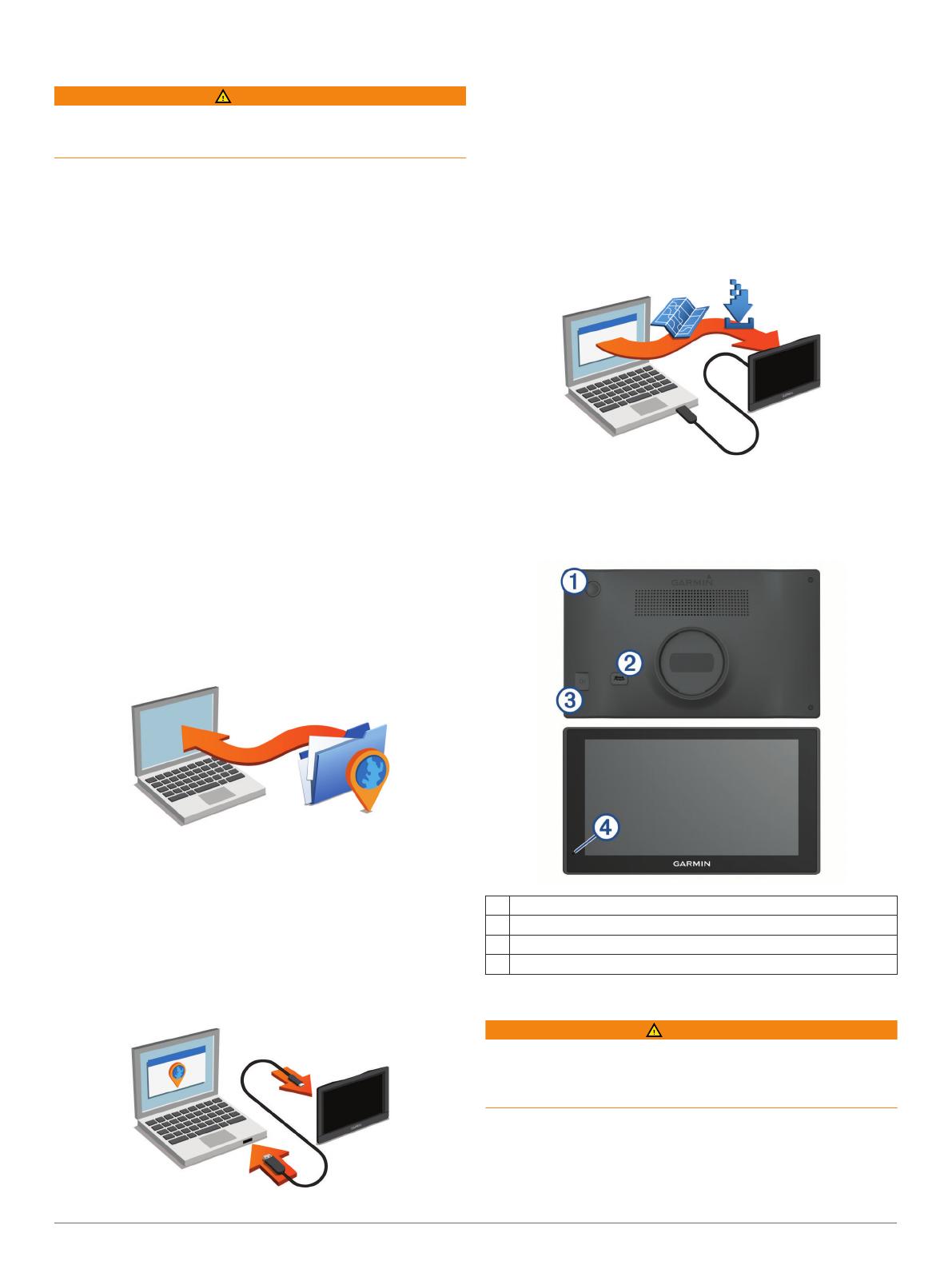
Updating Maps and Software with Garmin Express.............. 1
Garmin DriveTrack 70 Device Overview.....................................1
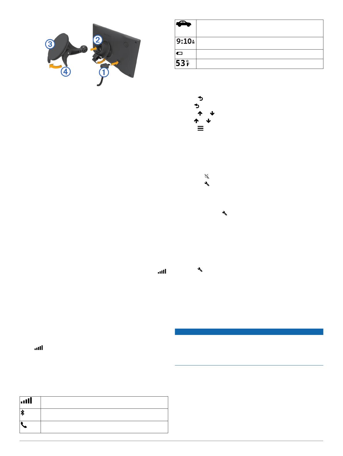
Connecting the Device to Vehicle Power................................... 1
Turning the Device On or Off...................................................... 2
Acquiring GPS Signals............................................................... 2
Status Bar Icons......................................................................... 2
Using the On-Screen Buttons..................................................... 2
Adjusting the Volume.................................................................. 2
Enabling Automatic Volume................................................... 2
Using the Audio Mixer............................................................ 2
Adjusting the Screen Brightness................................................ 2
Driver Awareness Features and Alerts........................ 2
Enabling or Disabling Audible Driver Alerts................................ 3
Red Light and Speed Cameras.................................................. 3
Navigating to Your Destination..................................... 3
Routes........................................................................................ 3
Starting a Route.......................................................................... 3
Starting a Route by Using the Map........................................ 3
Going Home........................................................................... 3
Your Route on the Map...............................................................3
Active Lane Guidance............................................................ 4
Viewing Turns and Directions................................................ 4
Viewing the Entire Route on the Map.................................... 4
Adding a Location to Your Route................................................ 4
Shaping Your Route................................................................... 4
Taking a Detour.......................................................................... 4
Stopping the Route..................................................................... 4
Changing the Route Calculation Mode....................................... 4
Trip Planner................................................................................ 5
Planning a Trip....................................................................... 5
Navigating to a Saved Trip.....................................................5
Optimizing the Order of Destinations in a Trip....................... 5
Editing and Reordering Locations in a Trip............................ 5
Editing and Saving Your Active Route................................... 5
Changing Routing Options for a Trip..................................... 5
Scheduling a Trip................................................................... 5
Using Suggested Routes............................................................ 5
Avoiding Delays, Tolls, and Areas.............................................. 5
Avoiding Traffic Delays on Your Route.................................. 5
Avoiding Toll Roads............................................................... 6
Avoiding Toll Stickers.............................................................6
Avoiding Road Features........................................................ 6
Avoiding Environmental Zones.............................................. 6
Custom Avoidances............................................................... 6
Navigating Off Road................................................................... 6
Finding and Saving Locations...................................... 6
Finding a Location Using the Search Bar................................... 6
Viewing Search Results on the Map........................................... 7
Changing the Search Area......................................................... 7
Points of Interest......................................................................... 7
Finding a Location by Category............................................. 7
Searching Within a Category................................................. 7
Navigating to Points of Interest Within a Venue.................... 7
Foursquare.............................................................................7
Search Tools...............................................................................7
Finding an Address................................................................ 7
Finding an Intersection...........................................................7
Finding a City......................................................................... 7
Finding a Location Using Coordinates................................... 8
Viewing Recently Found Locations............................................ 8
Clearing the List of Recently Found Locations...................... 8
Finding Your Last Parking Spot
.................................................. 8
Viewing Current Location Information........................................ 8
Finding Emergency Services and Fuel.................................. 8
Getting Directions to Your Current Location.......................... 8
Adding a Shortcut....................................................................... 8
Removing a Shortcut............................................................. 8
Saving Locations........................................................................ 8
Saving a Location.................................................................. 8
Saving Your Current Location................................................ 8
Editing a Saved Location....................................................... 8
Assigning Categories to a Saved Location............................ 8
Deleting a Saved Location..................................................... 8
Using the Map................................................................. 9
Map Tools................................................................................... 9
Viewing a Map Tool............................................................... 9
Enabling Map Tools............................................................... 9
Up Ahead.................................................................................... 9
Viewing Upcoming Locations................................................. 9
Customizing the Up Ahead Categories.................................. 9
Trip Information...........................................................................9
Viewing Trip Data from the Map............................................ 9
Viewing the Trip Information Page......................................... 9
Viewing the Trip Log.............................................................. 9
Resetting Trip Information......................................................9
Viewing Upcoming Traffic......................................................... 10
Viewing Traffic on the Map.................................................. 10
Searching for Traffic Incidents............................................. 10
Customizing the Map................................................................ 10
Customizing the Map Layers............................................... 10
Changing the Map Data Field.............................................. 10
Changing the Map Perspective............................................ 10
BirdsEye Imagery..................................................................... 10
Dog Tracking................................................................ 10
Receiving Data From Your Handheld Device........................... 10
Tracking Your Dogs.................................................................. 10
Dog Status Icons..................................................................10
Viewing Your Dogs on the Map................................................ 10
Viewing the Topographic Map.................................................. 10
Traffic Data.................................................................... 10
Receiving Traffic Data Using a Traffic Receiver....................... 11
About Traffic Subscriptions....................................................... 11
Viewing Traffic Subscriptions............................................... 11
Adding a Subscription.......................................................... 11
Enabling Traffic......................................................................... 11
Voice Command........................................................... 11
Setting the Wakeup Phrase...................................................... 11
Activating Voice Command.......................................................11
Voice Command Tips............................................................... 11
Starting a Route Using Voice Command.................................. 11
Muting Instructions....................................................................11
Voice Control............................................................................ 11
Configuring Voice Control.................................................... 11
Using Voice Control............................................................. 12
Voice Control Tips................................................................12
Hands-Free Calling....................................................... 12
Pairing Your Phone...................................................................12
Disconnecting a Bluetooth Device............................................ 12
Deleting a Paired Phone........................................................... 12
Using the Apps............................................................. 12
Viewing Help Files.................................................................... 12
Searching Help Topics......................................................... 12
Viewing Previous Routes and Destinations.............................. 12
Customizing the Device............................................... 12
Transportation Mode Settings.................................................. 12
Table of Contents i
Map and Vehicle Settings......................................................... 12
Enabling Maps..................................................................... 12
Navigation Settings................................................................... 12
Calculation Mode Settings................................................... 13
Setting a Simulated Location............................................... 13
Backup Camera Settings.......................................................... 13
babyCam Settings.................................................................... 13
Bluetooth Settings.....................................................................13
Disabling Bluetooth.............................................................. 13
Display Settings........................................................................ 13
Traffic Settings.......................................................................... 13
Units and Time Settings............................................................13
Setting the Time................................................................... 13
Language and Keyboard Settings............................................ 14
Proximity Alerts Settings........................................................... 14
Device and Privacy Settings..................................................... 14
Restoring Settings.................................................................... 14
Device Information....................................................... 14
Specifications............................................................................14
Power Cables........................................................................... 14
Charging the Device............................................................ 14
Device Maintenance..................................................... 14
Device Care.............................................................................. 14
Cleaning the Outer Casing...................................................14
Cleaning the Touchscreen................................................... 14
Avoiding Theft...................................................................... 14
Resetting the Device.................................................................14
Removing the Device, Mount, and Suction Cup....................... 14
Removing the Device from the Mount..................................14
Removing the Mount from the Suction Cup......................... 15
Removing the Suction Cup from the Windshield................. 15
Changing the Fuse in the Vehicle Power Cable....................... 15
Troubleshooting........................................................... 15
The suction cup will not stay on my windshield........................ 15
My device is not acquiring satellite signals............................... 15
The device does not charge in my vehicle............................... 15
My dogs do not appear on my screen...................................... 15
My battery does not stay charged for very long........................ 15
My device does not appear as a removable drive on my
computer................................................................................... 15
My device does not appear as a portable device on my
computer................................................................................... 15
My device does not appear as either a portable device or a
removable drive or volume on my computer.............................15
My phone will not connect to the device................................... 15
Appendix....................................................................... 16
Installing a Memory Card for Maps and Data........................... 16
Data Management.................................................................... 16
About Memory Cards........................................................... 16
Connecting the Device to Your Computer........................... 16
Transferring Data From Your Computer.............................. 16
Viewing GPS Signal Status...................................................... 16
Purchasing Additional Maps..................................................... 16
Purchasing Accessories........................................................... 16
Index.............................................................................. 17
ii Table of Contents
Getting Started
WARNING
See the Important Safety and Product Information guide in the
product box for product warnings and other important
information.
Update the maps and software on your device (Updating
Maps and Software with Garmin Express, page 1).
Mount the device in your vehicle and connect it to power
(Connecting the Device to Vehicle Power, page 1).
Acquire GPS signals (Acquiring GPS Signals, page 2).
Adjust the volume (Adjusting the Volume, page 2) and
display brightness (Adjusting the Screen Brightness,
page 2).
Navigate to your destination (Starting a Route, page 3).
Support and Updates
Garmin Express
(garmin.com/express) provides easy access
to these services for Garmin
®
devices.
Product registration
Product manuals
Software updates
Data uploads to Garmin Connect
Map, chart, or course updates
Vehicles, voices, and other extras
Updating Maps and Software with Garmin Express
You can use Garmin Express software to download and install
the latest map and software updates for your device. Map
updates provide the latest available mapping data to ensure
your device continues to calculate accurate and efficient routes
to your destinations. Garmin Express is available for Windows
®
and Mac
®
computers.
1
On your computer, go to www.garmin.com/express.
2
Select an option:
To install on a Windows computer, select Download for
Windows.
To install on a Mac computer, select Download for Mac.
3
Open the downloaded file, and follow the on-screen
instructions to complete the installation.
4
Start Garmin Express.
5
Connect your Garmin device to your computer using a USB
cable.
6
Click Add a Device.
The Garmin Express software detects your device.
7
Click Add Device.
8
Follow the on-screen instructions to add your device to the
Garmin Express software.
When setup is complete, the Garmin Express software
searches for map and software updates for your device.
9
Select an option:
To install all available updates, click Install All.
To install a single update, click View Details and select an
update.
The Garmin Express software downloads and installs the
updates onto your device. Map updates are very large, and this
process may take a long time on slower Internet connections.
Garmin DriveTrack 70 Device Overview
À
Power key
Á
Mini-USB power and data port
Â
Map and data memory card slot
Ã
Microphone for Voice Command or hands-free calling
Connecting the Device to Vehicle Power
WARNING
This product contains a lithium-ion battery. To prevent the
possibility of personal injury or product damage caused by
battery exposure to extreme heat, store the device out of direct
sunlight.
Before you use your device on battery power, you should charge
it.
1
Plug the vehicle power cable
À
into the USB port on the
device.
Getting Started 1
2
Press the mount
Á
onto the suction cup
Â
until it snaps into
place.
3
Press the suction cup to the windshield, and flip the lever
Ã
back toward the windshield.
4
Fit the tab on the top of the mount into the slot on the back of
the device.
5
Press the bottom of the mount into the device until it clicks.
6
Plug the other end of the vehicle power cable into a power
outlet in your vehicle.
Turning the Device On or Off
To turn the device on, press the power key, or connect the
device to power.
To put the device in power saving mode, press the power key
while the device is on.
While in power saving mode, the screen is off and the device
uses very little power, but it can wake instantly for use.
TIP: You can charge your device faster by putting it in power
saving mode while charging the battery.
To turn off the device completely, hold the power key until a
prompt appears on the screen, and select Off.
The prompt appears after five seconds. If you release the
power key before the prompt appears, the device enters
power saving mode.
Acquiring GPS Signals
When you turn on your navigation device, the GPS receiver
must collect satellite data and establish the current location.
in the status bar indicates the satellite signal strength. The time
required to acquire satellite signals varies based on several
factors, including how far you are from the location where you
last used your navigation device, whether you have a clear view
of the sky, and how long it has been since you last used your
navigation device. The first time you turn on your navigation
device, it may take several minutes to acquire satellite signals.
1
Turn on the device.
2
Wait while the device locates satellites.
3
If necessary, go outdoors to an open area, away from tall
buildings and trees.
When turns green, the device has acquired satellite signals
and is ready for navigation.
Status Bar Icons
The status bar is located at the top of the main menu. The status
bar icons display information about features on the device. You
can select some icons to change settings or view additional
information.
GPS signal status. Hold to view GPS accuracy and acquired
satellite information (Viewing GPS Signal Status, page 16).
Bluetooth
®
technology status. Select to view the Bluetooth
settings (Bluetooth Settings, page 13).
Connected to hands-free calling. Select to place a phone call
(Hands-Free Calling, page 12).
Active transportation mode. Select to change the
transportation mode (Transportation Mode Settings,
page 12).
Current time. Select to set the time (Setting the Time,
page 13).
Battery charge level.
Temperature. Select to view the weather forecast.
Using the On-Screen Buttons
On-screen buttons allow you to navigate the pages, menus, and
menu options on your device.
Select to return to the previous menu screen.
Hold to quickly return to the main menu.
Select or to scroll through lists or menus.
Hold or to scroll faster.
Select to see a context-based menu of options for the
current screen.
Adjusting the Volume
1
Select Volume.
2
Select an option:
Use the slider bar to adjust the volume.
Select to mute the device.
Select for additional options.
Enabling Automatic Volume
Your device can increase or decrease the volume automatically
based on the level of background noise.
1
Select Volume > .
2
Select Automatic Volume.
Using the Audio Mixer
You can use the audio mixer to set the volume levels for
different audio types, such as navigation prompts or phone calls.
The level for each audio type is a percentage of the master
volume.
1
Select Volume.
2
Select > Audio Mixer.
3
Use the sliders to adjust the volume for each audio type.
Adjusting the Screen Brightness
1
Select Settings > Display > Brightness.
2
Use the slider bar to adjust the brightness.
Driver Awareness Features and Alerts
NOTICE
The driver alerts and speed limit features are for information
only and do not replace your responsibility to abide by all posted
speed limit signs and to use safe driving judgment at all times.
Garmin is not responsible for any traffic fines or citations you
receive for failing to follow all applicable traffic laws and signs.
Your device provides features that can help encourage safer
driving and increase efficiency, even when you are driving in a
familiar area. The device plays an audible tone or message and
displays information for each alert. You can enable or disable
the audible tone or message for each type of alert. Not all alerts
are available in all areas.
School zone or nearby school: The device plays a tone and
displays the distance to and speed limit (if available) for an
upcoming school or school zone.
2 Driver Awareness Features and Alerts
Speed limit reduction: The device plays a tone and displays
the upcoming reduced speed limit so you can be prepared to
reduce your speed.
Speed limit exceeded: The device plays a tone and displays a
red border on the speed limit icon when you exceed the
posted speed limit for the current road.
Wrong way on a one-way street: The device plays a message
and displays a full-screen warning if you travel the wrong way
on a one-way street. The edges of the screen appear red and
an alert remains at the top of the screen until you leave the
one-way street or correct your direction of travel.
Railroad crossing: The device plays a tone and displays the
distance to an upcoming railroad crossing.
Animal crossing: The device plays a tone and displays the
distance to an upcoming animal crossing area.
Curve: The device plays a tone and displays the distance to a
curve in the road.
Slower traffic: The device plays a tone and displays the
distance to slower traffic when you approach slower traffic at
a higher speed. Your device must be receiving traffic
information to use this feature (Receiving Traffic Data Using
a Traffic Receiver, page 11).
Fatigue warning: The device plays a tone and suggests
upcoming rest stops after you have been driving for more
than two hours without stopping.
Enabling or Disabling Audible Driver Alerts
You can turn off individual audible driver alerts. The visual alert
appears even when the audible alert is disabled.
1
Select Settings > Map & Vehicle > Audible Driver Alerts.
2
Select or clear the check box next to each alert.
Red Light and Speed Cameras
NOTICE
Garmin is not responsible for the accuracy of or the
consequences of using a red light or speed camera database.
NOTE: This feature is not available for all regions or product
models.
Information about red light and speed camera locations is
available in some areas for some product models. Go to
garmin.com/speedcameras to check availability and
compatibility, or to purchase a subscription or one-time update.
You can purchase a new region or extend an existing
subscription at any time.
You can go to mygarmin.com to update the camera database on
your device. You should update your device frequently to
receive the most up-to-date camera information.
For some devices and regions, basic red light or speed camera
data may be included with your device. Included data does not
include updates or a subscription.
Navigating to Your Destination
Routes
A route is a path from your current location to one or more
destinations.
The device calculates a recommended route to your
destination based on the preferences you set, including the
route calculation mode (Changing the Route Calculation
Mode, page 4) and avoidances (Avoiding Delays, Tolls,
and Areas, page 5).
The device can automatically avoid roads that are not
appropriate for the active vehicle profile.
You can start navigating to your destination quickly using the
recommended route, or you can select an alternate route
(Starting a Route, page 3).
If there are specific roads you need to use or avoid, you can
customize the route (Shaping Your Route, page 4).
You can add multiple destinations to a route (Adding a
Location to Your Route, page 4).
Starting a Route
1
Select Where To?, and search for a location (Finding and
Saving Locations, page 6).
2
Select a location.
3
Select an option:
To start navigating using the recommended route, select
Go!.
To choose an alternate route, select , and select a route.
Alternate routes appear to the right of the map.
To edit the course of the route, select > Edit Route, and
add shaping points to the route (Shaping Your Route,
page 4).
The device calculates a route to the location and guides you
using voice prompts and information on the map (Your Route on
the Map, page 3). A preview of the major roads in your route
appears at the edge of the map for several seconds.
If you need to stop at additional destinations, you can add the
locations to your route (Adding a Location to Your Route,
page 4).
Starting a Route by Using the Map
You can start route by selecting a location from the map.
1
Select View Map.
2
Drag and zoom the map to display the area to search.
3
If necessary, select to filter the displayed points of interest
by category.
Location markers ( or a blue dot) appear on the map.
4
Select an option:
Select a location marker.
Select a point, such as a street, intersection, or address
location.
5
Select Go!.
Going Home
The first time you start a route home, the device prompts you to
enter your home location.
1
Select Where To? > Go Home.
2
If necessary, enter your home location.
Editing Your Home Location
1
Select Where To? > > Set Home Location.
2
Enter your home location.
Your Route on the Map
As you travel, the device guides you to your destination using
voice prompts and information on the map. Instructions for your
next turn or exit, or other actions appear across the top of the
map.
Navigating to Your Destination 3
À
Next action in the route. Indicates the next turn, exit, or other action
and the lane in which you should travel, if available.
Á
Distance to the next action.
Â
Name of the street or exit associated with the next action.
Ã
Route highlighted on the map.
Ä
Next action in the route. Arrows on the map indicate the location of
upcoming actions.
Å
Vehicle speed.
Æ
Name of the road on which you are traveling.
Ç
Estimated arrival time.
TIP: You can touch this field to change the information it shows
(Changing the Map Data Field, page 10).
Active Lane Guidance
As you approach a turn while navigating a route, a detailed
simulation of the road appears beside the map, if available. A
colored line
À
indicates the proper lane for the turn.
Viewing Turns and Directions
While navigating a route, you can view upcoming turns, lane
changes, or other directions for your route.
1
From the map, select an option:
To view upcoming turns and directions as you navigate,
select > Turns.
The map tool displays the next four turns or directions
beside the map. The list updates automatically as you
navigate the route.
To view the complete list of turns and directions for the
entire route, select the text bar at the top of the map.
2
Select a turn or direction (optional).
Detailed information appears. An image of the junction may
appear for junctions on major roadways, if available.
Viewing the Entire Route on the Map
1
While navigating a route, select anywhere on the map.
2
Select .
Adding a Location to Your Route
Before you can add a location to your route, you must be
navigating a route (Starting a Route, page 3).
You can add locations to the middle or end of your route. For
example, you can add a fuel station as the next destination in
your route.
TIP: To create complex routes with multiple destinations or
scheduled stops, you can use the trip planner to plan, schedule,
and save a trip (Planning a Trip, page 5).
1
From the map, select > Where To?.
2
Search for a location (Finding and Saving Locations,
page 6).
3
Select a location.
4
Select Go!.
5
Select an option:
To add the location as the next destination in your route,
select Add As Next Stop.
To add the location to the end of your route, select Add
As Last Stop.
To add the location and edit the order of destinations in
your route, select Add to Active Route.
The device re-calculates the route to include the added location
and guides you to the destinations in order.
Shaping Your Route
Before you can shape your route, you must start a route
(Starting a Route, page 3).
You can manually shape your route to change its course. This
allows you to direct the route to use a certain road or go through
a certain area without adding a destination to the route.
1
Touch anywhere on the map.
2
Select .
The device enters route shaping mode.
3
Select a location on the map.
TIP: You can select to zoom in on the map and select a
more precise location.
The device recalculates the route to travel through the
selected location.
4
If necessary, select an option:
To add more shaping points to the route, select additional
locations on the map.
To remove a shaping point, select .
5
When you are finished shaping the route, select Go!.
Taking a Detour
You can take a detour for a specified distance along your route
or detour around specific roads. This is useful if you encounter
construction zones, closed roads, or poor road conditions.
1
From the map, select > Change Route.
TIP: If the Change Route tool is not in the map tools menu,
you can add it (Enabling Map Tools, page 9).
2
Select an option:
To detour your route for a specific distance, select Detour
by Distance.
To detour around a specific road on the route, select
Detour by Road.
To find a new route, select Detour.
Stopping the Route
From the map, select > Stop.
Changing the Route Calculation Mode
1
Select Settings > Navigation > Calculation Mode.
2
Select an option:
Select Faster Time to calculate routes that are faster to
drive but can be longer in distance.
4 Navigating to Your Destination
Select Off Road to calculate point-to-point routes (without
roads).
Select Shorter Distance to calculate routes that are
shorter in distance but can take more time to drive.
Trip Planner
You can use the trip planner to create and save a trip, which you
can navigate later. This can be useful for planning a delivery
route, a vacation, or a road trip. You can edit a saved trip to
further customize it, including reordering locations, optimizing
the order of stops, adding scheduling information, and adding
shaping points.
You can also use the trip planner to edit and save your active
route.
Planning a Trip
A trip can include many destinations, and it must include at least
a starting location and one destination. The starting location is
the location from which you plan to start your trip. If you start
navigating the trip from a different location, the device gives you
the option to route to your starting location first. For a round trip,
the starting location and final destination can be the same.
1
Select Apps > Trip Planner > > Create Trip.
2
Select Select Start Location.
3
Choose a location for your starting point, and select Select.
4
Select Select Destination.
5
Choose a location for a destination, and select Select.
6
Select Add Location to add more locations (optional).
7
After you have added all the necessary locations, select Next
> Save.
8
Enter a name, and select Done.
Navigating to a Saved Trip
1
Select Apps > Trip Planner.
2
Select a saved trip.
3
Select Go!.
4
Select the first location to navigate to, and select Start.
The device calculates a route from your current location to
the selected location and then guides you to the remaining
trip destinations in order.
Optimizing the Order of Destinations in a Trip
The device can automatically optimize the order of destinations
in your trip to create a shorter, more efficient route. The starting
location and final destination are not changed when you
optimize the order.
While editing a trip, select > Optimize Order.
Editing and Reordering Locations in a Trip
1
Select Apps > Trip Planner.
2
Select a saved trip.
3
Select a location.
4
Select an option:
To move the location up or down, select , and drag the
location to a new position in the trip.
To add a new location after the selected location, select
.
To remove the location, select .
Editing and Saving Your Active Route
If a route is active, you can use the trip planner to edit and save
your route as a trip.
1
Select Apps > Trip Planner > My Active Route.
2
Edit your route using any of the trip planner features.
The route recalculates each time you make a change.
3
Select Save to save your route as a trip, which you can
navigate again later (optional).
Changing Routing Options for a Trip
You can customize how the device calculates the route when
you start your trip.
1
Select Apps > Trip Planner.
2
Select a saved trip.
3
Select the vehicle profile icon, and select the vehicle you plan
to use while navigating the trip (optional).
4
Select > Trip Settings.
5
Select an option:
To add shaping points to your trip, select Shape Route,
and follow the on-screen instructions (Shaping Your
Route, page 4).
To change the calculation mode for the trip, select Route
Preference (Changing the Route Calculation Mode,
page 4).
When you start navigating the trip, the device automatically
switches to the selected vehicle profile.
Scheduling a Trip
You can add scheduling information to each location in your trip,
including the desired arrival time and layover duration at each
location. This can help you plan your departure to reach
locations in your trip on time.
1
Select Apps > Trip Planner.
2
Select a trip.
3
Select > Trip Settings > Edit Schedule.
4
Select a location, and follow the on-screen instructions to
enter the schedule information.
TIP: If you need to schedule multiple locations in the trip, you
should start from the beginning of the trip and work toward
the end.
5
Repeat step 4 to enter schedule information for additional
locations.
6
When finished, select Save.
When you navigate the trip, you should depart by the time
shown under the starting point to reach your stops and
destinations by the scheduled time. The schedule is an estimate
only. Traffic conditions, construction, and other delays may
affect your actual arrival times.
Using Suggested Routes
Before you can use this feature, you must save at least one
location and enable the travel history feature (Device and
Privacy Settings, page 14).
Using the myTrends
feature, your device predicts your
destination based on your travel history, the day of the week,
and the time of day. After you have driven to a saved location
several times, the location may appear in the navigation bar on
the map, along with the estimated time of travel, and traffic
information.
Select the navigation bar to view a suggested route to the
location.
Avoiding Delays, Tolls, and Areas
Avoiding Traffic Delays on Your Route
Before you can avoid traffic delays, you must be receiving traffic
information (Receiving Traffic Data Using a Traffic Receiver,
page 11).
By default, the device optimizes your route to avoid traffic delays
automatically. If you have disabled this option in the traffic
settings (Traffic Settings, page 13), you can view and avoid
traffic delays manually.
Navigating to Your Destination 5
1
While navigating a route, select > Traffic.
2
Select Alternate Route, if available.
3
Select Go!.
Avoiding Toll Roads
Your device can avoid routing you through areas that require
tolls, such as toll roads, toll bridges, or congestion areas. The
device may still include a toll area in your route if no other
reasonable routes are available.
1
Select Settings > Navigation.
2
Select an option:
NOTE: The menu changes based on your area and the map
data on your device.
Select Toll Roads.
Select Tolls and Fees > Toll Roads.
3
Select an option:
To be asked each time before routing through a toll area,
select Always Ask.
To always avoid tolls, select Avoid.
To always allow tolls, select Allow.
4
Select Save.
Avoiding Toll Stickers
NOTE: This feature is not available in all areas.
The map data on your device may contain detailed toll sticker
information for some countries. You can avoid or allow toll
stickers for each country.
1
Select Settings > Navigation > Tolls and Fees > Toll
Stickers.
2
Select a country.
3
Select an option:
To be asked each time before routing through a toll area,
select Always Ask.
To always avoid tolls, select Avoid.
To always allow tolls, select Allow.
4
Select Save.
Avoiding Road Features
1
Select Settings > Navigation > Avoidances.
2
Select the road features to avoid on your routes, and select
Save.
Avoiding Environmental Zones
Your device can avoid areas with environmental or emissions
restrictions that may apply to your vehicle. This option applies to
the vehicle type in the active vehicle profile.
1
Select Settings > Navigation > Environmental Zones.
2
Select an option:
To be asked each time before routing through an
environmental zone, select Always Ask.
To always avoid environmental zones, select Avoid.
To always allow environmental zones, select Allow.
3
Select Save.
Custom Avoidances
Custom avoidances allow you select specific areas or sections
of road to avoid. When the device calculates a route, it avoids
these areas and roads unless no other reasonable route is
available.
Avoiding a Road
1
Select Settings > Navigation > Custom Avoidances.
2
Select Add Avoid Road.
3
Select the starting point of the section of road to avoid, and
select Next.
4
Select the ending point of the road section, and select Next.
5
Select Done.
Avoiding an Area
1
Select Settings > Navigation > Custom Avoidances.
2
If necessary, select Add Avoidance.
3
Select Add Avoid Area.
4
Select the upper-left corner of the area to avoid, and select
Next.
5
Select the lower-right corner of the area to avoid, and select
Next.
The selected area is shaded on the map.
6
Select Done.
Disabling a Custom Avoidance
You can disable a custom avoidance without deleting it.
1
Select Settings > Navigation > Custom Avoidances.
2
Select an avoidance.
3
Select > Disable.
Deleting Custom Avoidances
1
Select Settings > Navigation > Custom Avoidances.
2
Select an option:
To delete all custom avoidances, select .
To delete one custom avoidance, select the avoidance,
and select > Delete.
Navigating Off Road
If you are not following roadways as you navigate, you can use
Off Road mode.
1
Select Settings > Navigation.
2
Select Calculation Mode > Off Road > Save.
The next route will be calculated as a straight line to the
location.
Finding and Saving Locations
The maps loaded in your device contain locations, such as
restaurants, hotels, auto services, and detailed street
information. The Where To? menu helps you find your
destination by providing several methods to browse, search, and
save this information.
Enter search terms to quickly search all location information
(Finding a Location Using the Search Bar, page 6).
Browse or search pre-loaded points of interest by category
(Points of Interest, page 7).
Search and check into Foursquare
®
points of interest
(Searching Foursquare Points of Interest, page 7).
Use search tools to find specific locations, such as
addresses, intersections, or geographic coordinates (Search
Tools, page 7).
Search near a different city or area (Changing the Search
Area, page 7).
Save your favorite locations to find them quickly in the future
(Saving Locations, page 8).
Return to recently found locations (Viewing Recently Found
Locations, page 8).
Finding a Location Using the Search Bar
You can use the search bar to search for locations by entering a
category, brand name, address, or city name.
1
Select Where To?.
6 Finding and Saving Locations
2
Select Enter Search in the search bar.
3
Enter all or part of the search term.
Suggested search terms appear below the search bar.
4
Select an option:
To search for a type of business, enter a category name
(for example, "movie theaters").
To search for a business name, enter all or part of the
name.
To search for an address near you, enter the house
number and street name.
To search for an address in another city, enter the house
number, street name, city, and state.
To search for a city, enter the city and state.
To search for coordinates, enter latitude and longitude
coordinates.
5
Select an option:
To search using a suggested search term, select the term.
To search using the text you entered, select .
6
If necessary, select a location.
Viewing Search Results on the Map
You can view the results of a location search on the map instead
of in a list.
1
From the location search results, select .
The nearest location in your search results appears on the
map. indicates the locations of other search results.
2
Select one or more options:
To view more search results, touch and drag the map.
To select another location, select .
To view details and routes for the selected location, select
the location description at the bottom of the map.
To start navigation to the selected location, select Go!.
Changing the Search Area
By default, the device searches near your current location. You
can also search other areas, such as near your destination, near
another city, or along your active route.
1
From the main menu, select Where To?.
2
Select .
3
Select an option.
Points of Interest
A point of interest is a place that you may find useful or
interesting. Points of interest are organized by category and can
include popular travel destinations such as gas stations,
restaurants, hotels, and entertainment venues.
Finding a Location by Category
1
Select Where To?.
2
Select a category, or select Categories.
3
If necessary, select a subcategory.
4
Select a location.
Searching Within a Category
After you have performed a search for a point of interest, certain
categories may display a Quick Search list that shows the last
four destinations you selected.
1
Select Where To? > Categories.
2
Select a category.
3
Select an option:
Select a destination from the quick search list on the right
side of the screen.
The quick search list provides a list of recently found
locations in the selected category.
Select a subcategory, if necessary, and select a
destination.
Navigating to Points of Interest Within a Venue
You can create a route to a point of interest (POI) within a larger
venue, such as a store in a shopping mall or a specific terminal
in an airport.
1
Select Where To? > Enter Search.
2
Select an option:
To search for the venue, enter the name or address of the
venue, select , and go to step 3.
To search for the POI, enter the name of the POI, select
, and go to step 5.
3
Select the venue.
A list of categories appears below the venue, such as
restaurants, car rentals, or terminals.
4
Select a category.
5
Select the POI, and select Go!.
The device creates a route to the parking area or venue
entrance closest to the POI. When you arrive at the destination,
a checkered flag indicates the recommended parking area. A
labeled point indicates the location of the POI within the venue.
Exploring a Venue
You can view a list of all points of interest located within each
venue.
1
Select a venue.
2
Select > Explore this Venue.
Foursquare
Foursquare is a location-based social network. Your device
includes pre-loaded Foursquare points of interest, which are
indicated by the Foursquare logo in your location search results.
Searching Foursquare Points of Interest
You can search for Foursquare points of interest loaded on your
device.
Select Where To? > Categories > Foursquare®.
Search Tools
Search tools allow you to search for specific types of locations
by responding to on-screen prompts.
Finding an Address
NOTE: The order of the steps may change depending on the
map data loaded on your device.
1
Select Where To?.
2
If necessary, select Searching near: to change the search
area (Changing the Search Area, page 7).
3
Select Address.
4
Follow the on-screen instructions to enter address
information.
5
Select the address.
Finding an Intersection
You can search for an intersection or junction between two
streets, highways, or other roads.
1
Select Where To? > Categories > Intersections.
2
Follow the on-screen instructions to enter street information.
3
Select the intersection.
Finding a City
1
Select Where To? > Categories > Cities.
Finding and Saving Locations 7
2
Select an option:
Select a city from the list of nearby cities.
To search near another location, select Searching near:
(Changing the Search Area, page 7).
To search for a city by name, select Enter Search, enter a
city name, and select .
Finding a Location Using Coordinates
You can find a location using latitude and longitude coordinates.
This can be helpful when geocaching.
1
Select Where To? > Categories > Coordinates.
2
If necessary, select , and change the coordinate format or
datum.
3
Enter the latitude and longitude coordinates.
4
Select View on Map.
Viewing Recently Found Locations
Your device stores a history of the last 50 locations you have
found.
Select Where To? > Recent.
Clearing the List of Recently Found Locations
Select Where To? > Recent > > Clear > Yes.
Finding Your Last Parking Spot
When you disconnect the device from vehicle power while the
device is on, your current location is saved as a parking spot.
Select Apps > Last Spot.
Viewing Current Location Information
You can use the Where Am I? page to view information about
your current location. This feature is helpful if you need to tell
emergency personnel your location.
From the map, select the vehicle.
Finding Emergency Services and Fuel
You can use the Where Am I? page to find the nearest
hospitals, police stations, and fuel stations.
1
From the map, select the vehicle.
2
Select Hospitals, Police Stations, Fuel, or Roadside
Assist.
NOTE: Some service categories are not available in all
areas.
A list of locations for the selected service appears, with the
nearest locations at the top.
3
Select a location.
4
Select an option:
To navigate to the location, select Go!.
To view the phone number and other location details,
select .
Getting Directions to Your Current Location
If you need to tell another person how to get to your current
location, your device can give you a list of directions.
1
From the map, select the vehicle.
2
Select > Directions to Me.
3
Select a starting location.
4
Select Select.
Adding a Shortcut
You can add shortcuts to the Where To? menu. A shortcut can
point to a location, a category, or a search tool.
The Where To? menu can contain up to 36 shortcut icons.
1
Select Where To? > Add Shortcut.
2
Select an item.
Removing a Shortcut
1
Select Where To? > > Remove Shortcut(s).
2
Select a shortcut to remove.
3
Select the shortcut again to confirm.
4
Select Save.
Saving Locations
Saving a Location
1
Search for a location (Finding a Location by Category,
page 7).
2
From the search results, select a location.
3
Select .
4
Select Save.
5
If necessary, enter a name, and select Done.
Saving Your Current Location
1
From the map, select the vehicle icon.
2
Select Save.
3
Enter a name, and select Done.
4
Select OK.
Editing a Saved Location
1
Select Where To? > Saved.
2
If necessary, select a category.
3
Select a location.
4
Select .
5
Select > Edit.
6
Select an option:
Select Name.
Select Phone Number.
Select Categories to assign categories to the saved
location.
Select Change Map Symbol to change the symbol used
to mark the saved location on a map.
7
Edit the information.
8
Select Done.
Assigning Categories to a Saved Location
You can add custom categories to organize your saved
locations.
NOTE: Categories appear in the saved locations menu after you
have saved at least 12 locations.
1
Select Where To? > Saved.
2
Select a location.
3
Select .
4
Select > Edit > Categories.
5
Enter one or more category names, separated by commas.
6
If necessary, select a suggested category.
7
Select Done.
Deleting a Saved Location
NOTE: Deleted locations cannot be recovered.
1
Select Where To? > Saved.
2
Select > Delete Saved Places.
3
Select the box next to the saved locations to delete, and
select Delete.
8 Finding and Saving Locations
Using the Map
You can use the map to navigate a route (Your Route on the
Map, page 3) or to view a map of your surroundings when no
route is active.
1
Select View Map.
2
Touch anywhere on the map.
3
Select an option:
Drag the map to pan left, right, up, or down.
To zoom in or out, select or .
To switch between North Up and 3-D views, select .
To filter the displayed points of interest by category, select
.
To start a route, select a location on the map, and select
Go! (Starting a Route by Using the Map, page 3).
Map Tools
Map tools provide quick access to information and device
functions while you view the map. When you activate a map
tool, it appears in a panel at the edge of the map.
Stop: Stops navigation of the active route.
Change Route: Allows you to take a detour or skip locations in
your route.
Up Ahead: Displays upcoming locations along the route or the
road on which you are traveling (Up Ahead, page 9).
Turns: Displays a list of upcoming turns in your route (Viewing
Turns and Directions, page 4).
Trip Data: Displays customizable trip data, such as speed or
mileage (Viewing Trip Data from the Map, page 9).
Volume: Adjusts the master audio volume.
Brightness: Adjusts the screen brightness.
Phone: Displays a list of recent phone calls from your
connected phone, and displays in-call options while a phone
call is active.
Weather: Displays weather conditions for your area.
Viewing a Map Tool
1
From the map, select .
2
Select a map tool.
The map tool appears in a panel at the edge of the map.
3
When you are done using the map tool, select .
Enabling Map Tools
By default, only the most commonly used map tools are enabled
in the map tools menu. You can add up to 12 tools to the menu.
1
From the map, select > .
2
Select the check box next to each tool to add.
3
Select Save.
Up Ahead
The Up Ahead tool provides information about upcoming
locations along your route or the road on which you are
traveling. You can view upcoming points of interest, such as
restaurants, fuel stations, or rest areas. When traveling on a
highway, you can also view information and available services
for upcoming exits and cities, similar to the information on
highway road signs.
You can customize three categories to show in the Up Ahead
tool.
Viewing Upcoming Locations
1
From the map, select > Up Ahead.
2
Select an option:
To view the next upcoming location in each category,
select , if necessary.
To view information and available services for upcoming
highway exits or cities, select .
NOTE: This option is available only while you are traveling
on a highway or when your route includes a highway.
3
Select an item to view a list of locations for that category,
exit, or city.
Customizing the Up Ahead Categories
You can change the location categories that appear in the Up
Ahead tool.
1
From the map, select > Up Ahead.
2
Select a category.
3
Select .
4
Select an option:
To move a category up or down in the list, select and drag
the arrow next to the category name.
To change a category, select the category.
To create a custom category, select a category, select
Custom Search, and enter the name of a business or
category.
5
Select Done.
Trip Information
Viewing Trip Data from the Map
Before you can view trip data on the map, you must add the tool
to the map tools menu (Enabling Map Tools, page 9).
From the map, select > Trip Data.
Customizing the Trip Data Fields
Before you can customize the data that appears in the trip data
map tool, you must add the trip data tool to the map tools menu
(Enabling Map Tools, page 9).
1
From the map, select > Trip Data.
2
Select a trip data field.
3
Select an option.
The new trip data field appears in the trip data map tool.
Viewing the Trip Information Page
The trip information page displays your speed and provides
statistics about your trip.
NOTE: If you make frequent stops, leave the device turned on,
so it can accurately measure elapsed time during the trip.
From the map, select Speed.
Viewing the Trip Log
Your device keeps a trip log, which is a record of the path you
have traveled.
1
Select Settings > Map & Vehicle > Map Layers.
2
Select the Trip Log check box.
Resetting Trip Information
1
From the map, select Speed.
2
Select > Reset Field(s).
3
Select an option:
When not navigating a route, select Select All to reset
every data field except the speedometer, on the first page.
Select Reset Trip Data to reset the information on the trip
computer.
Select Reset Max. Speed to reset the maximum speed.
Select Reset Trip B to reset the odometer.
Using the Map 9
Viewing Upcoming Traffic
You can view traffic incidents coming up along your route or
along the road on which you are traveling.
1
While navigating a route, select > Traffic.
The nearest upcoming traffic incident appears in a panel on
the right side of the map.
2
Select the traffic incident to view additional details.
Viewing Traffic on the Map
The traffic map shows color-coded traffic flow and delays on
nearby roads.
1
From the main menu, select Apps > Traffic.
2
If necessary, select > Legend to view the legend for the
traffic map.
Searching for Traffic Incidents
1
From the main menu, select Apps > Traffic.
2
Select > Incidents.
3
Select an item in the list.
4
If there is more than one incident, use the arrows to view
additional incidents.
Customizing the Map
Customizing the Map Layers
You can customize which data appear on the map, such as
icons for points of interest and road conditions.
1
Select Settings > Map & Vehicle > Map Layers.
2
Select the layers to include on the map, and select Save.
Changing the Map Data Field
1
From the map, select a data field.
NOTE: You cannot customize Speed.
2
Select a type of data to display.
Changing the Map Perspective
1
Select Settings > Map & Vehicle > Driving Map View.
2
Select an option:
Select Track Up to display the map in two dimensions (2-
D), with your direction of travel at the top.
Select North Up to display the map in 2-D with north at
the top.
Select 3-D to display the map in three dimensions.
3
Select Save.
BirdsEye Imagery
You can download and view detailed satellite imagery on your
device using Garmin BaseCamp
software and a BirdsEye
imagery subscription. Go to garmin.com/birdseye and
garmin.com/basecamp for more information.
Your device may include a one-year BirdsEye imagery
subscription. This subscription is not available in all areas or for
all device models.
Dog Tracking
The dog tracking features allow you to see information
transmitted from your handheld device on your Garmin
DriveTrack 70 device. You can navigate to your dogs, view their
current status and location, and observe the distance they have
traveled.
Receiving Data From Your Handheld Device
Before you can receive data, you must enable broadcasting on
your handheld device. See the owner's manual for your
handheld device for more information.
Place your handheld device within 3 m (10 ft) of your Garmin
DriveTrack device.
TIP: Your Garmin DriveTrack device receives data from one
compatible handheld device at a time. Stay more than 3 m
(10 ft) away from other handheld devices or disable
broadcasting on handheld devices from which you do not
want to receive data.
The devices connect and synchronize automatically. When your
Garmin DriveTrack device receives data from a compatible
handheld device, appears on the main menu.
Tracking Your Dogs
1
Select Dogs.
The dogs connected to your handheld device appear on the
screen.
2
Select a dog.
The dog's location and track log appear on the map.
3
Select Go! to navigate to your dog.
Dog Status Icons
Icons indicate the status and location of your dogs.
Sitting
Running
On point
Treed
Unknown*
Collar battery low
Collar connection lost
Collar GPS reception lost
*The unknown status icon indicates the collar has not acquired a
satellite signal and the handheld device cannot determine the
location of the dog.
Viewing Your Dogs on the Map
1
While viewing the map, select anywhere on the map.
2
Select .
The device zooms to show all of your dogs on the screen.
Viewing the Topographic Map
From the map, select > Topo Map.
TIP: If the Topo Map map tool is not in the map tools menu,
you can add it (Enabling Map Tools, page 9).
Traffic Data
NOTICE
Garmin is not responsible for the accuracy or timeliness of the
traffic information.
Traffic data is not available in all areas or for all product models.
For information about traffic receivers and coverage areas, go to
www.garmin.com/traffic.
To avoid traffic delays, your device must receive live traffic data.
If your device includes a traffic receiver, it can receive traffic
data from an over-the-air broadcast signal, where available.
10 Dog Tracking
An FM traffic receiver is included in product models ending
with LT or LMT.
A digital traffic receiver is included in product models ending
with LMT-D or LMTHD.
The device must be connected to vehicle power using the
included power cable to receive traffic data using the traffic
receiver.
The device must be within range of a traffic data signal to
receive information using the traffic receiver.
Receiving Traffic Data Using a Traffic
Receiver
NOTICE
Heated (metallized) windshields could degrade the performance
of the traffic receiver.
If your device includes a traffic receiver, it can receive traffic
data from an over-the-air broadcast signal, where available. This
feature is not available in all areas or for all product models.
NOTE: In some areas, traffic information may be received from
FM radio stations using HD Radio
technology.
1
Verify your device includes a traffic receiver.
An FM traffic receiver is included in product models
ending with LT or LMT.
A digital traffic receiver is included in product models
ending with LMT-D or LMTHD.
2
Connect the device to vehicle power using the power cable
included with your device (Connecting the Device to Vehicle
Power, page 1).
The power cable included with your device includes an
antenna for the traffic receiver.
When you are within a traffic coverage area, your device can
display traffic information and help you avoid traffic delays.
About Traffic Subscriptions
You can purchase additional subscriptions or a renewal if your
subscription expires. Go to http://www.garmin.com/traffic.
Viewing Traffic Subscriptions
Select Settings > Traffic > Subscriptions.
Adding a Subscription
You can purchase traffic subscriptions for other regions or
countries.
1
From the main menu, select Traffic.
2
Select Subscriptions > .
3
Write down the FM traffic receiver unit ID.
4
Go to www.garmin.com/fmtraffic to purchase a subscription
and get a 25-character code.
The traffic subscription code cannot be reused. You must
obtain a new code each time you renew your service. If you
own multiple FM traffic receivers, you must obtain a new
code for each receiver.
5
Select Next on the device.
6
Enter the code.
7
Select Done.
Enabling Traffic
You can enable or disable traffic data.
1
Select Settings > Traffic.
2
Select the Traffic check box.
Voice Command
NOTE: Voice command is not available for all languages and
regions, and may not be available on all models.
NOTE: Voice Activated Navigation may not achieve desired
performance when in a noisy environment.
Voice command allows you to use your device by saying words
and commands. The voice command menu provides voice
prompts and a list of available commands.
Setting the Wakeup Phrase
The wakeup phrase is a word or phrase you can say to activate
voice command. The default wakeup phrase is Voice Command.
TIP: You can reduce the chance of accidental voice command
activation by using a strong wakeup phrase.
1
Select Apps > Voice Command > > Wake Up Phrase.
2
Enter a new wakeup phrase.
The device indicates the strength of the wakeup phrase as
you enter the phrase.
3
Select Done.
Activating Voice Command
Say your wakeup phrase.
The voice command menu appears.
Voice Command Tips
Speak in a normal voice directed at the device.
Reduce background noise, such as voices, or the radio, to
increase the accuracy of the voice recognition.
Speak commands as they appear on the screen.
Respond to voice prompts from the device as needed.
Increase the length of your wakeup phrase to reduce the
chance of accidental voice command activation.
Listen for two tones to confirm when the device enters and
exits voice command.
Starting a Route Using Voice Command
You can say the names of popular, well-known locations.
1
Say your wakeup phrase (Setting the Wakeup Phrase,
page 11).
2
Say Find Place.
3
Listen for the voice prompt, and speak the name of the
location.
4
Say the line number.
5
Say Navigate.
Muting Instructions
You can disable the voice prompts for voice command without
muting the device.
1
Select Apps > Voice Command > .
2
Select Mute Instructions > Enabled.
Voice Control
For regions where the Voice Command feature is unavailable,
the Voice Control feature is activated. Voice Control allows you
to use your voice to control the device. Before you can use the
Voice Control feature, you must configure it for your voice.
Configuring Voice Control
The Voice Control feature must be configured for a single user's
voice and does not work for other users.
1
Select Apps > Voice Control.
Voice Command 11
2
Follow the on-screen instructions to record commands for
each voice control phrase.
NOTE: You do not have to read the exact phrase on the
screen. You may say an alternative command with the same
meaning based on your preference.
To use a voice control feature, you must say the command you
recorded for the feature.
Using Voice Control
1
Say the command you recorded for the Voice Control
phrase.
The voice control menu appears.
2
Follow the on-screen instructions.
Voice Control Tips
Speak in a normal voice directed at the device.
Reduce background noise, such as voices, or the radio, to
increase the accuracy of the voice recognition.
Speak commands as they appear on the screen.
Listen for a tone to confirm when the device successfully
receives a command.
Hands-Free Calling
NOTE: While most phones are supported and can be used, it
cannot be guaranteed that a particular phone can be used. All
features may not be available for your phone.
Using Bluetooth wireless technology, your device can connect to
your mobile phone to become a hands-free device. While
connected, you can place or receive calls using your device.
Pairing Your Phone
Before you can use hands-free calling, you must pair your
device with a compatible mobile phone.
1
Place your phone and your Bluetooth device within 33 ft.
(10 m) of each other.
2
On your device, enable Bluetooth wireless technology.
3
Select Settings > Bluetooth > Search for Devices.
4
On your phone, enable Bluetooth wireless technology.
5
On your device, select OK.
A list of nearby Bluetooth devices appears.
6
Select your phone from the list, and select OK.
7
If necessary, on your phone, confirm the device is allowed to
connect.
8
If necessary, enter the device Bluetooth PIN into your phone.
Disconnecting a Bluetooth Device
You can temporarily disconnect a Bluetooth device without
deleting it from the paired devices list. The Bluetooth device can
connect to your Garmin DriveTrack device automatically in the
future.
1
Select Settings > Bluetooth.
2
Select the device to disconnect.
3
Clear the check box next to the name of your paired device.
Deleting a Paired Phone
You can delete a paired phone to prevent it from automatically
connecting to your device in the future.
1
Select Settings > Bluetooth.
2
Select the phone, and select Unpair device.
Using the Apps
Viewing Help Files
Select Apps > Help to view the full owner's manual.
Searching Help Topics
Select Apps > Help > .
Viewing Previous Routes and Destinations
Before you can use this feature, you must enable the travel
history feature (Device and Privacy Settings, page 14).
You can view your previous routes and places you have stopped
on the map.
Select Apps > Where I've Been.
Customizing the Device
Transportation Mode Settings
Select Settings > Transportation Mode.
Prompted: Prompts you to select a transportation mode when
receiving data from a handheld device.
Automobile: Enables a transportation mode for navigating
streets.
Dog Tracking: Enables a transportation mode for navigating to
dogs off road.
Map and Vehicle Settings
Select Settings > Map & Vehicle.
Dog Labels: Sets the labels that appear next to your dog's
location on the map.
Audible Dog Alerts: Enables an audible alert for dog status
changes.
Vehicle: Sets the icon that represents your position on the map.
Go to www.garmingarage.com for more icons.
Driving Map View: Sets the perspective on the map.
Map Detail: Sets the level of detail on the map. More detail may
cause the map to draw slower.
Map Theme: Changes the color of the map data.
Map Tools: Sets the shortcuts that appear in the map tools
menu.
Map Layers: Sets the data that appears on the map page
(Customizing the Map Layers, page 10).
Audible Driver Alerts: Enables an audible alert for each type of
driver alert (Driver Awareness Features and Alerts, page 2).
Auto Zoom: Automatically selects the zoom level for optimal
use of your map. When disabled, you must zoom in or out
manually.
myMaps: Sets which installed maps the device uses.
Enabling Maps
You can enable map products installed on your device.
TIP: To purchase additional map products, go to
http://buy.garmin.com.
1
Select Settings > Map & Vehicle > myMaps.
2
Select a map.
Navigation Settings
Select Settings > Navigation.
Route Preview: Shows a preview of the major roads in your
route when you start navigation.
Calculation Mode: Sets the route calculation method.
12 Hands-Free Calling
Fatigue Warning: Alerts you when you have been driving for a
long period without a break.
Avoidances: Sets road features to avoid on a route.
Custom Avoidances: Allows you to avoid specific roads or
areas.
Environmental Zones: Sets the avoidance preferences for
areas with environmental or emissions restrictions that may
apply to your vehicle.
Toll Roads: Sets preferences for avoiding toll roads.
Tolls and Fees: Sets preferences for avoiding toll roads and toll
stickers.
NOTE: This feature is not available in all areas.
Restricted Mode: Disables all functions that require significant
operator attention and could become a distraction while
driving.
GPS Simulator: Stops the device from receiving a GPS signal,
and saves battery power.
Calculation Mode Settings
Select Settings > Navigation > Calculation Mode.
The route calculation is based on road speeds and vehicle
acceleration data for a given route.
Faster Time: Calculates routes that are faster to drive but can
be longer in distance.
Shorter Distance: Calculates routes that are shorter in distance
but can take more time to drive.
Off Road: Calculates a direct line from your location to your
destination.
Setting a Simulated Location
If you are indoors or not receiving satellite signals, you can use
the GPS to set a simulated location.
1
Select Settings > Navigation > GPS Simulator.
2
From the main menu, select View Map.
3
Tap the map twice to select an area.
The address of the location appears at the bottom of the
screen.
4
Select the location description.
5
Select Set Location.
Backup Camera Settings
The backup camera settings allow you to manage paired
Garmin backup cameras and camera settings. This menu
appears on your navigation device only when the device is
connected to a wireless camera receiver cable. See the owner's
manual for your backup camera for detailed information about
pairing cameras and camera settings. Go to garmin.com
/backupcamera to purchase a Garmin backup camera.
Select Settings > Backup Camera, and select a paired camera.
Unpair: Removes the paired camera. You must pair the camera
again before you can view it using this device and cable.
Rename: Allows you to rename the paired camera.
Guidance Lines: Shows or hides guidance lines and allows you
to adjust the position of the guidance lines.
babyCam Settings
The babyCam settings allow you to manage paired Garmin
babyCam
cameras and camera settings. This menu appears
on your navigation device only when the device is connected to
a wireless camera receiver cable. See the owner's manual for
your camera for detailed information about pairing cameras and
camera settings. Go to garmin.com/babycam to purchase a
Garmin babyCam camera.
Select Settings > babyCam, and select a paired camera.
Power Settings: Allows you to set the amount of time the video
appears on the screen.
Flip Video: Allows you to flip or mirror the video.
Alignment: Displays the babyCam video to help you align the
camera.
Check Seat Reminder: Enables a reminder to check for rear
seat passengers before exiting the vehicle.
Unpair: Removes the paired camera.
Rename: Allows you to rename the paired camera.
Bluetooth Settings
Select Settings > Bluetooth.
Bluetooth: Enables Bluetooth wireless technology.
Search for Devices: Searches for nearby Bluetooth devices.
Friendly Name: Allows you to enter a friendly name that
identifies your device on other devices with Bluetooth
wireless technology.
Disabling Bluetooth
1
Select Settings > Bluetooth.
2
Select Bluetooth.
Display Settings
Select Settings > Display.
Color Mode: Allows you to select day or night color mode. If you
select the Auto option, the device automatically switches to
day or night colors based on the time of day.
Brightness: Allows you to adjust the display brightness.
Display Timeout: Allows you to set the amount of idle time
before your device enters sleep mode while using battery
power.
Screenshot: Allows you to take a picture of the device screen.
Screenshots are saved in the Screenshot folder of the device
storage.
Traffic Settings
From the main menu, select Settings > Traffic.
Traffic: Enables traffic.
Current Provider: Sets the traffic provider to use for traffic data.
The Auto option selects the best available traffic data
automatically.
Subscriptions: Lists the current traffic subscriptions.
Optimize Route: Enables the device to use optimized alternate
routes automatically or upon request (Avoiding Traffic Delays
on Your Route, page 5).
Traffic Alerts: Sets the traffic delay severity for which the
device displays a traffic alert.
trafficTrends: Enables the trafficTrends
feature.
Units and Time Settings
To open the Units and Time settings page, from the main menu,
select Settings > Units & Time.
Current Time: Sets the device time.
Time Format: Allows you to select a 12-hour, 24-hour, or UTC
display time.
Units: Sets the unit of measure used for distances.
Position Format: Sets the coordinate format and datum used
for geographical coordinates.
Setting the Time
1
From the main menu, select the time.
Customizing the Device 13
2
Select an option:
To set the time automatically using GPS information,
select Automatic.
To set the time manually, drag the numbers up or down.
Language and Keyboard Settings
To open the Language and Keyboard settings, from the main
menu, select Settings > Language & Keyboard.
Voice Language: Sets the language for voice prompts.
Text Language: Sets all on-screen text to the selected
language.
NOTE: Changing the text language does not change the
language of user-entered data or map data, such as street
names.
Keyboard Language: Enables keyboard languages.
Proximity Alerts Settings
NOTE: You must have custom points of interest (POIs) loaded
for proximity points alerts to display.
NOTE: This feature is not available in all areas.
Select Settings > Proximity Alerts.
Audio: Sets the style of alert that plays when you approach
proximity points.
Alerts: Sets the type of proximity points for which alerts are
played.
Device and Privacy Settings
To open the device settings, select Settings > Device.
About: Displays the software version number, the unit ID
number, and information on several other software features.
EULAs: Displays the end-user license agreements.
NOTE: You need this information when you update the
system software or purchase additional map data.
Position Reporting: Shares your position information with
Garmin to improve content.
Travel History: Allows the device to record information for the
myTrends, Where I’ve Been, and Trip Log features.
Clear Travel History: Clears your travel history for the
myTrends, Where I’ve Been, and Trip Log features.
Restoring Settings
You can restore a category of settings or all settings to the
factory default values.
1
Select Settings.
2
If necessary, select a settings category.
3
Select > Restore.
Device Information
Specifications
Operating
temperature range
From -20° to 55°C (from -4° to 131°F)
Charging
temperature range
From 0° to 45°C (from 32° to 113°F)
Power input Vehicle power using the included vehicle power
cable. AC power using an optional accessory
(for home and office use only).
Battery type Rechargeable lithium-ion
Power Cables
Your device can be powered various ways.
Vehicle power cable
USB cable
AC adapter (optional accessory)
Charging the Device
NOTE: This Class III product shall be powered by an LPS power
supply.
You can charge the battery in the device using any of these
methods.
Connect the device to vehicle power.
Connect the device to a computer using a USB cable.
The device may charge slowly when connected to a
computer. Some portable computers may not charge the
device.
Connect the device to an optional power adapter accessory,
such as a wall power adapter.
You can purchase an approved Garmin AC-DC adapter
suitable for home or office use from a Garmin dealer or
www.garmin.com.
Device Maintenance
Device Care
NOTICE
Avoid dropping your device.
Do not store the device where prolonged exposure to extreme
temperatures can occur, because it can cause permanent
damage.
Never use a hard or sharp object to operate the touchscreen, or
damage may result.
Do not expose the device to water.
Cleaning the Outer Casing
NOTICE
Avoid chemical cleaners and solvents that can damage plastic
components.
1
Clean the outer casing of the device (not the touchscreen)
using a cloth dampened with a mild detergent solution.
2
Wipe the device dry.
Cleaning the Touchscreen
1
Use a soft, clean, lint-free cloth.
2
If necessary, lightly dampen the cloth with water.
3
If using a dampened cloth, turn off the device and disconnect
the device from power.
4
Gently wipe the screen with the cloth.
Avoiding Theft
Remove the device and mount from sight when not in use.
Remove the residue left on the windshield by the suction cup.
Do not keep your unit in the glove compartment.
Register your device at http://my.garmin.com.
Resetting the Device
You can reset your device if it stops functioning.
Hold the power key for 12 seconds.
Removing the Device, Mount, and Suction
Cup
Removing the Device from the Mount
1
Press the release tab or button on the mount.
2
Tilt the device forward.
14 Device Information
Removing the Mount from the Suction Cup
1
Turn the device mount to the right or left.
2
Apply pressure until the socket on the mount releases the
ball on the suction cup.
Removing the Suction Cup from the Windshield
1
Flip the lever on the suction cup toward you.
2
Pull the tab on the suction cup toward you.
Changing the Fuse in the Vehicle Power
Cable
NOTICE
When replacing the fuse, do not lose any of the small pieces
and make sure they are put back in the proper position. The
vehicle power cable does not work unless it is assembled
correctly.
If your device does not charge in your vehicle, you may need to
replace the fuse located at the tip of the vehicle adapter.
1
Rotate the end piece
À
90 degrees counter clockwise to
unlock it.
TIP: You may need to use a coin to remove the end piece.
2
Remove the end piece, the silver tip
Á
, and the fuse
Â
.
3
Insert a new fast-blow fuse that has the same current, such
as 1 A or 2 A.
4
Place the silver tip in the end piece.
5
Push in the end piece and rotate it 90 degrees clockwise to
lock it back into the vehicle power cable
Ã
.
Troubleshooting
The suction cup will not stay on my
windshield
1
Clean the suction cup and windshield with rubbing alcohol.
2
Dry with a clean, dry cloth.
3
Mount the suction cup (Connecting the Device to Vehicle
Power, page 1).
My device is not acquiring satellite signals
Verify the GPS simulator is turned off (Navigation Settings,
page 12).
Take your device out of parking garages and away from tall
buildings and trees.
Remain stationary for several minutes.
The device does not charge in my vehicle
Check the fuse in the vehicle power cable (Changing the
Fuse in the Vehicle Power Cable, page 15).
Verify the vehicle is turned on and is supplying power to the
power outlet.
Verify the interior temperature of the vehicle is within the
charging temperature range indicated in the specifications.
Verify the fuse is not broken in the vehicle power outlet.
My dogs do not appear on my screen
Verify your compatible handheld device is within 3 m (10 ft) of
your Garmin DriveTrack device.
Verify broadcasting is enabled on your handheld device
(Receiving Data From Your Handheld Device, page 10).
Verify your collars are turned on and connected to your
handheld device.
For more information, see the owner's manual for your
handheld device.
My battery does not stay charged for very
long
Decrease the screen brightness (Display Settings, page 13).
Shorten the display timeout (Display Settings, page 13).
Decrease the volume (Adjusting the Volume, page 2).
Disable Bluetooth wireless technology (Disabling Bluetooth,
page 13).
Put the device in power saving mode when not in use
(Turning the Device On or Off, page 2).
Keep your device away from extreme temperatures.
Do not leave your device in direct sunlight.
My device does not appear as a removable
drive on my computer
On most Windows computers, the device connects using Media
Transfer Protocol (MTP). In MTP mode, the device appears as a
portable device and not as a removable drive. MTP mode is
supported by Windows 7, Windows Vista
®
, and Windows XP
Service Pack 3 with Windows Media Player 10.
My device does not appear as a portable
device on my computer
On Mac computers and some Windows computers, the device
connects using USB mass storage mode. In USB mass storage
mode, the device appears as a removable drive or volume, and
not as a portable device. Windows versions prior to Windows XP
Service Pack 3 use USB mass storage mode.
My device does not appear as either a
portable device or a removable drive or
volume on my computer
1
Disconnect the USB cable from your computer.
2
Turn off the device.
3
Connect the USB cable to your device and to a USB port on
your computer.
TIP: The USB cable must connect to a USB port on your
computer, not to a USB hub.
The device turns on automatically and goes into MTP mode or
USB mass storage mode. A picture of the device connected to a
computer appears on the device screen.
NOTE: If you have several network drives mapped on your
computer, Windows may have trouble assigning drive letters to
your Garmin drives. For information about assigning drive
letters, see the help file for your operating system.
My phone will not connect to the device
Select Settings > Bluetooth.
The Bluetooth field must be set to Enabled.
Enable Bluetooth wireless technology on your phone and
bring your phone within 33 ft. (10 m) of the device.
Go to www.garmin.com/bluetooth for more help.
Troubleshooting 15
Appendix
Installing a Memory Card for Maps and Data
You can install a memory card to increase the storage space for
maps and other data on your device. You can purchase memory
cards from an electronics supplier, or go to www.garmin.com
/maps to purchase a memory card with pre-loaded Garmin
mapping software. The device supports microSD
memory
cards from 4 to 32 GB.
1
Locate the map and data memory card slot on your device
(Garmin DriveTrack 70 Device Overview, page 1).
2
Insert a memory card into the slot.
3
Press it in until it clicks.
Data Management
You can store files on your device. The device has a memory
card slot for additional data storage.
NOTE: The device is not compatible with Windows 95, 98, Me,
Windows NT
®
, and Mac OS 10.3 and earlier.
About Memory Cards
You can purchase memory cards from an electronics supplier,
or purchase pre-loaded Garmin mapping software
(www.garmin.com). In addition to map and data storage, the
memory card can be used to store files such as maps, images,
geocaches, routes, waypoints, and custom POIs.
Connecting the Device to Your Computer
You can connect the device to your computer using a USB
cable.
1
Plug the small end of the USB cable into the port on the
device.
2
Plug the larger end of the USB cable into a port on your
computer.
A picture of your device connected to a computer appears on
the device screen.
Depending on your computer operating system, the device
appears as either a portable device, a removable drive, or a
removable volume.
Transferring Data From Your Computer
1
Connect the device to your computer (Connecting the Device
to Your Computer, page 16).
Depending on your computer operating system, the device
appears as either a portable device, a removable drive, or a
removable volume.
2
On your computer, open the file browser.
3
Select a file.
4
Select Edit > Copy.
5
Browse to a folder on the device.
NOTE: For a removable drive or volume, you should not
place files in the Garmin folder.
6
Select Edit > Paste.
Disconnecting the USB Cable
If your device is connected to your computer as a removable
drive or volume, you must safely disconnect your device from
your computer to avoid data loss. If your device is connected to
your Windows computer as a portable device, it is not necessary
to safely disconnect.
1
Complete an action:
For Windows computers, select the Safely Remove
Hardware icon in the system tray, and select your device.
For Mac computers, drag the volume icon to the trash.
2
Disconnect the cable from your computer.
Viewing GPS Signal Status
Hold for three seconds.
Purchasing Additional Maps
1
Go to your device product page at garmin.com.
2
Click the Maps tab.
3
Follow the on-screen instructions.
Purchasing Accessories
Go to garmin.com/accessories.
16 Appendix
1 / 1

Garmin DriveTrack 70 Owner's manual

Category
Car navigation systems
Type
Owner's manual
This manual is also suitable for

Ask a question and I''ll find the answer in the document

Finding information in a document is now easier with AI

Ask the document