
Page 1
190-00643-00 REV. A
400/500 SERIES FDE PREDICTION INSTRUCTIONS
NOTE: These instructions assume the user has experience operating the applicable 400/500 Series Unit and is familiar with the
operation of RAIM. The fi gures in this addendum are derived from the 400/500 Series units. The information in this document
applies to all 400/500 units unless otherwise stated.
FAULT DETECTION AND EXCLUSION (FDE)
The GARMIN 400/500 Series Main and GPS Software version 3.00 and higher (Figure 1) incorporate Fault Detection and
Exclusion (FDE) display interface and control, satisfying the requirements for “GPS as a Primary Means of Navigation for Oceanic/
Remote Operations” per FAA Notice N8110.60.
FDE consists of two distinct parts, fault detection and fault exclusion. The fault detection part detects the presence of an
unacceptably large pseudorange error (and presumably, position error) for a given mode of fl ight. Upon the detection, fault
exclusion follows and excludes the source of the unacceptably large pseudorange error, thereby allowing navigation to return to
normal performance without an interruption in service. To enhance safety, FDE functionality is provided for other phases of fl ight
(non-precision approach, terminal, en route). The FDE functionality for non-oceanic fl ight phases adheres to the same missed alert
probability, false alert probability, and failed exclusion probability specifi ed by N8110.60.
The following 400/500 Series Units are affected:
• GPS 400
• GNC 420/420A
• GNS 430/430A
• GPS 500 (TAWS)
• GNS 530/530A (TAWS)
Figure 1. Software Version Screen
PRE-DEPARTURE VERIFICATION OF FDE
An FDE prediction must be performed prior to departure for a fl ight plan involving:
• Oceanic/Remote operation where GPS is to be the sole source of navigation per FAA Notice 8110.60
• U.S. Area Navigation (RNAV) routes, Standard Instrument Departures (SIDs), or Standard Terminal Arrival Routes (STARs) if a
NOTAM indicates a GPS satellite (or satellites) is scheduled to be out-of-service, per FAA AC 90-100 “U.S. Terminal and En Route
Area Navigation (RNAV) Operations”
Prior to departure, the operator must use the FDE Prediction Program supplied with the 400/500 Trainer Software to
demonstrate that there are no outages in the capability to navigate on the specifi ed route of fl ight (the FDE Prediction Program
determines whether the GPS constellation is robust enough to provide a navigation solution for the specifi ed route of fl ight).
Page 2
FDE PREDICTION PROGRAM
Your 400/500 Series Trainer software includes an FDE Prediction Program to meet the requirements for GPS as a primary means
of navigation for oceanic/remote operations (reference FAA Notice 8110.60). The oceanic fl ight phase occurs on your 400/500
Series unit when you are more than 200 nautical miles from the nearest airport. All operators using the 400/500 Series unit as
primary means of navigation in oceanic/remote areas under FAR parts 91, 121, 125 and 135 must utilize the FDE Prediction
Program prior to conducting a fl ight in these areas.
All operators must also utilize the FDE Prediction Program prior to navigation on U.S. RNAV routes, SIDs, and STARs if a
NOTAM indicates a GPS satellite (or satellites) is scheduled to be out-of-service (reference FAA AC 90-100).
FDE is an acronym for Fault Detection and Exclusion. The detection function refers to the capability to detect a satellite failure
which can affect navigation. The exclusion function refers to the capability to exclude one or more failed satellites and prevent them
from affecting navigation. The FDE function is built into the 400/500 Series unit and does not require pilot interaction. In contrast,
the FDE Prediction Program does require pilot interaction and must be used prior to oceanic/remote area fl ights, and for U.S. RNAV
routes, SIDs, and STARs to predict FDE availability. The FDE Prediction Program allows you to specify the planned ground speed,
route space, and maximum allowable outage. When provided through NOTAM or other sources, satellites with known failures can
be excluded through the program's setup function.
To use the FDE Prediction Program, begin by entering the intended fl ight plan into the 400/500 Series Trainer software. The
FDE Prediction Program uses this information to analyze satellite coverage along your intended route of fl ight.
To create a fl ight plan prior to using the FDE Prediction Program:
1. With the 400/500 Series Trainer running and the simulated
400/500 Series unit
on, click on the unit’s FPL button to display the fl ight
plan pages.
2. Click on the clockwise arrow of the unit's small right knob to display the list of saved fl ight plans.
3. Click on the unit's MENU button, then click on the clockwise arrow of the unit's large right knob to highlight "Create New Flight
Plan?". Click on the unit's ENT button to begin creating a new fl ight plan.
4. Use the unit's small and large right knobs to enter the identifi er of the fi rst fl ight plan waypoint. Click on the unit's ENT button once
the identifi er for the desired waypoint is displayed.
5. Repeat step #4 to enter each additional fl ight plan waypoint, ending at the fi nal destination airport.
Prior to running the FDE Prediction Program, the fl ight plan created in the preceding steps needs to be activated. The FDE
Prediction Program only works with the currently active fl ight plan.
To activate a saved fl ight plan:
1. With the 400/500 Series Trainer running and the simulated
400/500 Series unit on, click on the unit’s FPL button to display
the fl ight plan pages.
2. Click on the clockwise arrow of the unit's small right knob to
display the list of saved fl ight plans.
3. Click on the unit's small right knob to enable the cursor, then click
on the clockwise arrow of the large right knob to highlight the
desired saved route.
4. Click on the unit's MENU button, then click on the clockwise
arrow of the unit's large right knob to highlight "Activate Flight
Plan?". Click on the unit's ENT button to activate the fl ight plan.
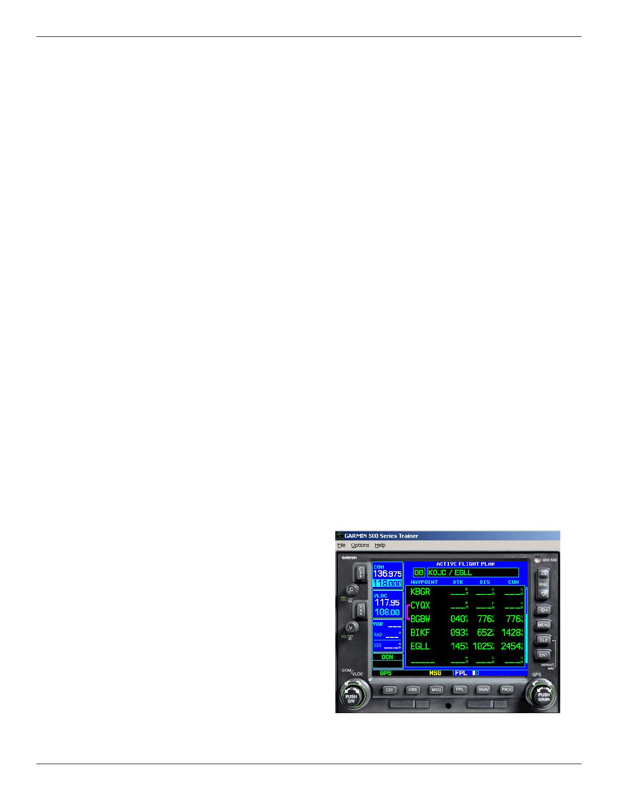
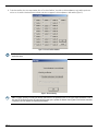
The active fl ight plan page will be displayed (Figure 2).
190-00643-00 REV. A
Figure 2. Active Flight Plan Page

Page 3
To run the FDE Prediction Program:
1. With the 400/500 Series Trainer running, the simulated
400/500 unit
on, and the desired fl ight plan active, select the ‘Options’ menu
in the upper left corner (Figure 2).
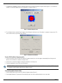
2. Select ‘Fde Prediction Program’. The FDE Prediction Program window will appear (Figure 3), listing the fl ight plan waypoints and the
current time as the departure time.
Figure 3. FDE Prediction Window
3. To change the departure date, click on the down arrow adjacent to the ‘Date (UTC)’ fi eld. A calendar window appears. Click on the left
or right arrows to select a different month (if desired), then click on the desired date.
4. To change the departure time, click on the hours, minutes or seconds fi elds adjacent to the ‘Time (UTC)’ fi eld. Click on the up or down
arrows to change the displayed time.
5. To change the planned ground speed, route space or maximum allowed outage, click on the ‘Setup button’. A setup window is
displayed (Figure 4). Click on the fi eld for the desired item, then enter the desired value.
Figure 4. Flight Setup Window
NOTE: Although the Flight Setup window refers to Oceanic Phase of Flight, the prediction will be correct even when Route Space
of 1 or 2 NM is selected for U.S. RNAV routes, SIDs, or STARs.
190-00643-00 REV. A

Page 4
6. To deselect satellites from the setup window, click on ‘De-select Satellites’, then click on the box adjacent to any satellite you do not
wish to use. A satellite is deselected when a check mark does not appear in the box adjacent to that satellite (Figure 5).
Figure 5. Selected Satellites Window
NOTE: Satellites that are unavailable will be ‘greyed-out’, with no check marks. Satellites labeled as ‘Poor Health’ will default to
unchecked status.
Figure 6. Almanac Warning
NOTE: To ensure accuracy of results, the almanac data used for FDE prediction needs to be recent. If the information is out of
date, the FDE Prediction Program will automatically prompt you to update the almanac data (Figure 6). An internet connection
is required to use this feature (see following instructions).
190-00643-00 REV. A

Page 5
7. To calculate FDE availability, select the ‘Calculate’ button from the main FDE Prediction Program window (Figure 3). A ‘Calculation is
complete’ message will appear when the FDE prediction is complete (Figure 7).
Figure 7. Calculation Complete Screen
8. The Calculation Results window (Figure 8) appears after clicking the OK button on the ‘Calculation is complete’ message screen. The
results can be viewed, or printed for later reference.
Figure 8. Calculations Results Window
To view FDE Prediction Program results:
1. Select the View menu from the main FDE Prediction Program window (the results also appear automatically after clicking the OK
button on the ‘Calculation is complete’ message screen).
2. Select Results. A window will appear, showing the calculation results (Figure 8).
3. To print the calculation results, click on the Print button.
NOTE: The ‘FDE is available for this route’ result must be displayed for Oceanic, and U.S. RNAV routes, SIDs, or STARs navigation
in compliance with FAA Notice N8110.60 and FAA AC 90-100.
To manually update almanac data:
1. Select the Help menu from the main FDE Prediction Program window (Figure 3).
2. Select Update Alamanac. The program will automatically search the internet and download the most recent data.
190-00643-00 REV. A

© Copyright 2005
Garmin Ltd. or its subsidiaries
c/o Garmin International, Inc.
1200 East 151st Street
Olathe, Kansas 66062, U.S.A.
Garmin (Europe) Ltd.
Unit 5, The Quadrangle, Abbey Park Industrial Estate, Romsey, SO51 9AQ, U.K.
Garmin Corporation
No. 68, Jangshu 2nd Road, Shijr, Taipei County, Taiwan
-
 1
1
-
 2
2
-
 3
3
-
 4
4
-
 5
5
-
 6
6


Ask a question and I''ll find the answer in the document
Finding information in a document is now easier with AI
Related papers
-
Garmin G1000 Operating instructions
-
Garmin GPS Receiver User manual
-
Garmin GNS 480 User guide
-
Garmin GAD™ 42 Installation guide
-
-
Garmin GPS 400W Owner's manual
-
Garmin SA01933LA_D Airplane Flight Manual Supplement
-
Garmin GPS 500W Owner's manual
-
-
Garmin G1000 Nxi - Piper PA-46 Meridian Owner's manual

