Garmin BMW Motorrad Navigator V Owner's manual
- Category
- Car navigation systems
- Type
- Owner's manual


All rights reserved. Under the copyright laws, this manual may not be copied, in whole or in part, without the written consent of Garmin. Garmin reserves the
right to change or improve its products and to make changes in the content of this manual without obligation to notify any person or organization of such
changes or improvements. Go to www.garmin.com for current updates and supplemental information concerning the use of this product.
Garmin
®
and the Garmin logo are trademarks of Garmin Ltd. or its subsidiaries, registered in the USA and other countries. nüMaps Lifetime
™
and TracBack
®
are
trademarks of Garmin Ltd. or its subsidiaries. These trademarks may not be used without the express permission of Garmin.
The Bluetooth
®
word mark and logos are owned by the Bluetooth SIG, Inc., and any use of such name by Garmin is under license. microSD
™
is a trademark of
SD-3C.
BMW
®
is a registered trademark of BMW AG.
This Class III product shall be powered by a limited power supply (LPS).

Table of Contents
Getting Started............................................................... 1
Contact Information.................................................................... 1
Installing the Battery................................................................... 1
Turning On the Device................................................................ 1
Turning Off the Device................................................................ 1
Resetting the Device.............................................................. 1
Removing the Battery................................................................. 1
Installing Your Device in the Motorcycle Mount.......................... 1
Removing Your Device from the Motorcycle Mount...............2
About the Motorcycle Mount....................................................... 2
Mounting Your Device in an Automobile.................................... 2
Support and Updates.................................................................. 2
Setting Up Garmin Express................................................... 2
Activating Lifetime Maps........................................................ 2
About Sleep Mode...................................................................... 2
Entering Sleep Mode............................................................. 2
Exiting Sleep Mode................................................................ 2
Adjusting the Screen Brightness................................................ 2
Adjusting the Volume.................................................................. 3
Status Bar Icons......................................................................... 3
Choosing a Transportation Mode.......................................... 3
Battery Information..................................................................... 3
Setting the Time..........................................................................3
Using the On-Screen Buttons..................................................... 3
Using the On-Screen Keyboard.................................................. 3
About Shortcuts.......................................................................... 3
Adding a Shortcut.................................................................. 3
Removing a Shortcut............................................................. 3
About Locations............................................................. 3
Finding BMW Dealers................................................................. 3
Contact Information................................................................3
Finding Locations........................................................................3
Finding a Location by Category............................................. 3
Searching Within a Category............................................ 3
Finding a Location Using the Search Bar.............................. 3
Changing the Search Area.................................................... 4
Finding a Location by Browsing the Map............................... 4
Finding an Address................................................................ 4
Finding Recently Found Destinations.................................... 4
Clearing the List of Recently Found Locations................. 4
Finding Parking...................................................................... 4
Finding Your Last Parking Spot........................................ 4
Search Tools.......................................................................... 4
Finding an Intersection...................................................... 4
Finding a City.................................................................... 4
Finding a Location Using Coordinates.............................. 4
Setting a Simulated Location................................................. 4
Saving Locations....................................................................4
Saving a Location..............................................................4
Saving Your Current Location........................................... 4
Starting a Route to a Saved Location............................... 4
Editing a Saved Location.................................................. 4
Assigning Categories to a Saved Location....................... 5
Deleting a Saved Location................................................ 5
Saving a Home Location................................................... 5
Finding Recently Found Destinations.................................... 5
Clearing the List of Recently Found Locations...................... 5
Navigation....................................................................... 5
Starting a Route.......................................................................... 5
Previewing Multiple Routes....................................................5
Changing the Route Calculation Mode.................................. 5
Navigating Off Road.......................................................... 5
Taking a Route Using Curvy Roads.................................. 5
Starting a Route to a Saved Location
.................................... 5
Your Route on the Map...............................................................5
Using the Navigation Map...................................................... 5
Adding a Point to a Route...................................................... 6
Skipping a Point in Your Route......................................... 6
Taking a Detour..................................................................... 6
Stopping the Route................................................................ 6
Using Suggested Routes....................................................... 6
About Exit Services.....................................................................6
Finding Exit Services............................................................. 6
Navigating to an Exit.............................................................. 6
Map Pages....................................................................... 6
Customizing the Map.................................................................. 6
Customizing the Map Layers................................................. 6
Viewing the Trip Log.............................................................. 6
Changing the Map Data Field................................................ 6
Customizing Map Buttons...................................................... 6
Removing Buttons from the Map.......................................6
Changing the Map Dashboard............................................... 6
Changing the Map Perspective.............................................. 6
Viewing Route Activity................................................................ 6
Viewing a List of Turns...........................................................6
Viewing the Entire Route on the Map............................... 7
Viewing the Next Turn............................................................7
Viewing Junctions.................................................................. 7
Viewing Traffic Alerts............................................................. 7
Viewing the Trip Computer.................................................... 7
Resetting Trip Information................................................. 7
Viewing Current Location Information........................................ 7
Finding Nearby Services........................................................ 7
Getting Directions to Your Current Location.......................... 7
Hands-Free Voice Prompts........................................... 7
About Wireless Headsets........................................................... 7
Enabling Bluetooth Wireless Technology.............................. 7
Pairing a Wireless Headset........................................................ 7
Deleting a Paired Headset..................................................... 7
Disconnecting Your Headset................................................. 7
Tips After Pairing the Devices................................................7
Using the Apps............................................................... 7
Using Help.................................................................................. 7
Searching Help Topics........................................................... 7
Smartphone Link.........................................................................8
Downloading Smartphone Link.............................................. 8
Connecting to Smartphone Link........................................ 8
Sending a Location from Your Phone to Your Device........... 8
Disabling Calls While Connected to Smartphone Link.......... 8
About Garmin Live Services....................................................... 8
Subscribing to Garmin Live Services..................................... 8
Viewing the Weather Forecast....................................................8
Viewing Weather Near a Different City.................................. 8
Viewing the Weather Radar................................................... 8
Viewing Weather Alerts..........................................................8
Checking Road Conditions.................................................... 8
Trip Planner................................................................................ 8
About Via Points.................................................................... 8
About Shaping Points............................................................ 8
Planning a Trip to Destination................................................ 9
Adding Points to a Trip...........................................................9
Scheduling a Trip................................................................... 9
Changing Transportation Modes in a Trip............................. 9
Navigating to a Saved Trip.....................................................9
Editing a Saved Trip...............................................................9
Tracks......................................................................................... 9
Viewing Track Information..................................................... 9
TracBack®.................................................................................. 9
Table of Contents i

Following Your Recent Track................................................. 9
Saving Your Recent Track as a Trip...................................... 9
Using the Compass.................................................................... 9
Viewing Previous Routes and Destinations................................ 9
Using the World Clock.............................................................. 10
Viewing the World Map........................................................ 10
Setting an Alarm....................................................................... 10
Using the Calculator................................................................. 10
Converting Units....................................................................... 10
Setting Currency Conversion Rates.....................................10
About the Media Player............................................................ 10
Supported File Types........................................................... 10
Playing Music....................................................................... 10
Creating a Playlist................................................................ 10
Creating a Playlist on a Computer.................................. 10
Editing the Current Playlist...................................................10
Traffic............................................................................ 10
About Traffic on Your Route..................................................... 10
Viewing Upcoming Traffic.................................................... 10
Manually Avoiding Traffic on Your Route............................ 10
Taking an Alternate Route................................................... 11
Viewing Traffic on the Map.................................................. 11
Traffic in Your Area................................................................... 11
Searching for Traffic Incidents............................................. 11
Viewing a Traffic Incident on the Map.................................. 11
Searching for Traffic Incidents............................................. 11
Understanding Traffic Data....................................................... 11
Disabling Traffic........................................................................ 11
Data Management......................................................... 11
File Types................................................................................. 11
About Memory Cards................................................................ 11
Installing a Memory Card..................................................... 11
Connecting the Device to Your Computer................................ 11
Transferring Data From Your Computer................................... 11
Disconnecting the USB Cable..............................................11
Customizing the Device............................................... 11
Map and Vehicle Settings......................................................... 11
Enabling Maps..................................................................... 12
Navigation Settings................................................................... 12
Calculation Mode Settings................................................... 12
Display Settings........................................................................ 12
Bluetooth Settings.....................................................................12
Disabling Bluetooth.............................................................. 12
Traffic Settings.......................................................................... 12
Units and Time Settings............................................................12
Language and Keyboard Settings............................................ 12
Proximity Alerts Settings........................................................... 12
Device and Privacy Settings..................................................... 12
Restoring Settings.................................................................... 12
Appendix....................................................................... 13
Power Cables........................................................................... 13
Charging the Device............................................................ 13
Device Care.............................................................................. 13
Cleaning the Outer Casing...................................................13
Cleaning the Touchscreen................................................... 13
Avoiding Theft...................................................................... 13
Extending the Battery Life.................................................... 13
Replacing the Battery...........................................................13
Locking the Device...............................................................13
Changing the Fuse in the Vehicle Power Cable....................... 13
Purchasing Additional Maps..................................................... 13
Safety Cameras........................................................................ 13
Custom Points of Interest......................................................... 14
Installing POI Loader........................................................... 14
Using the POI Loader Help Files......................................... 14
Finding Custom POIs
........................................................... 14
Purchasing Accessories........................................................... 14
Troubleshooting........................................................... 14
My device is not acquiring satellite signals............................... 14
The device does not charge in my vehicle............................... 14
The touchscreen is not responding to my touches................... 14
The suction cup will not stay on my windshield........................ 14
My battery does not stay charged for very long........................ 14
The battery gauge does not seem accurate............................. 14
My device does not appear as a removable drive on my
computer................................................................................... 14
My device does not appear as a portable device on my
computer................................................................................... 14
My device does not appear as either a portable device or a
removable drive or volume on my computer.............................14
My phone will not connect to the device................................... 14
My device is locked up or frozen.............................................. 14
I need to erase all my user data............................................... 14
Specifications............................................................... 14
Index.............................................................................. 16
ii Table of Contents

Getting Started
WARNING
See the Important Safety and Product Information guide in the
product box for product warnings and other important
information.
Contact Information
If you encounter any difficulty while using your BMW Navigator
V, or if you have any questions, contact your BMW Motorrad
dealer.
Installing the Battery
1
Locate the screwdriver
À
that came in the product box.
2
Locate the lithium-ion battery in the product box.
3
Loosen the screws and remove the battery compartment
cover.
4
If necessary, insert a microSD
™
card
Á
into the device.
5
Insert the battery with its cable on top.
6
Insert the battery connector
Â
into the battery port
Ã
.
7
Insert the battery cover, top side first
Ä
.
8
Close the battery cover
Å
and tighten the screws.
NOTE: Do not over-tighten the screws.
Turning On the Device
NOTE: The device turns on automatically if it is in the optional
motorcycle or automotive mount and external power is
connected and turned on.
Press the power key.
Turning Off the Device
1
Hold the power key until a prompt appears on the screen.
The prompt appears after five seconds. If you release the
power key before the prompt appears, the device enters
sleep mode.
2
Select Off.
Resetting the Device
You can reset your device if it stops functioning.
Hold the power key for 10 seconds.
Removing the Battery
You can remove the battery if you do not plan on using the
device for an extended period of time.
1
Loosen the screws and remove the battery compartment
cover.
2
Press and hold the release tab on the battery connectory
while gently pulling the connector away from the device.
Installing Your Device in the Motorcycle
Mount
CAUTION
Before driving, ensure the top of the latch is flat and even with
the top of the device and the mount.
NOTE: The motorcycle mount is not included in all kits.
1
Fit the bottom of your device into the cradle.
Getting Started 1

2
Tilt your device back until it snaps into place and the top of
the latch is flat.
NOTE: Remove the device from the motorcycle mount before
connecting a battery charger to your motorcycle.
Removing Your Device from the Motorcycle Mount
1
Press the release button
À
on the side of the mount.
2
Lift out the device.
About the Motorcycle Mount
You can access specific device features using the buttons on
the motorcycle mount.
À
Select to zoom in and out on the map.
Select to use functionality marked with a or .
Á
Select to view the map, compass, trip computer, and media player.
Hold to open the brightness settings.
Â
Select to hear the current prompt when you have a Bluetooth
®
helmet or headset connected.
Hold to open the volume settings.
Mounting Your Device in an Automobile
NOTE: The automotive mount is included with the optional car
kit.
NOTICE
Before mounting the device, check the local laws pertaining to
windshield mounting.
WARNING
This product contains a lithium-ion battery. To prevent the
possibility of personal injury or product damage caused by
battery exposure to extreme heat, store the device out of direct
sunlight.
Do not use the suction cup mount on a motorcycle.
See the Important Safety and Product Information guide in the
product box for product warnings and other important
information.
1
Plug the small end of the automotive power cable
À
into the
port on the side of the automotive mount
Á
.
2
Remove the clear plastic from the suction cup.
3
Clean and dry your windshield and the suction cup with a lint-
free cloth.
4
Press the suction cup
Â
to the windshield, and flip the lever
Ã
back toward the windshield.
5
Snap the mount onto the suction cup arm.
6
Fit the bottom of your device into the cradle.
7
Tilt the device back until it snaps into place.
8
Plug the other end of the automotive power cable into a
power source.
Support and Updates
Garmin
®
Express provides easy access to these services for
your device.
• Product registration
• Software and map updates
• Product manuals
• Vehicles, voices, and other extras
Setting Up Garmin Express
1
Plug the small end of the USB cable into the port on the
device.
2
Plug the larger end of the USB cable into an available USB
port on your computer.
3
Go to www.garmin.com/express.
4
Follow the on-screen instructions.
Activating Lifetime Maps
NOTE: Lifetime Maps are not applicable to products that do not
have pre-loaded maps.
NOTE: Lifetime Maps entitle you to receive map updates when
and as such updates are made available by Garmin during the
useful life of one compatible Garmin product or as long as
Garmin receives map data from a third party supplier, whichever
is shorter. For the meaning of a product’s “useful life” and for
other important terms and conditions, go to www.garmin.com
/numapslifetime.
1
Go to www.garmin.com/express.
2
Follow the on-screen instructions.
NOTE: If you register the device, you can receive e-mail
notifications when a map update is available.
About Sleep Mode
Use sleep mode to conserve battery power when your device is
not in use. Sleep mode uses very little power, and a battery
charge lasts for weeks when your device is in sleep mode.
Entering Sleep Mode
Press the Power key.
Exiting Sleep Mode
While the device is in sleep mode, press the Power key.
Adjusting the Screen Brightness
1
Select Settings > Display > Brightness.
2 Getting Started

2
Select or to adjust the screen brightness.
Adjusting the Volume
1
Select Volume.
2
Select an option:
• Select or to adjust the volume.
• Select to mute the device.
• Select for additional options.
Status Bar Icons
The status bar is located at the top of the main menu. The status
bar icons display information about features on the device. You
can select some icons to change settings or view additional
information.
GPS signal status.
Bluetooth technology status (appears when Bluetooth is
enabled).
Connected to Smartphone Link.
Transportation mode indicator. Allows you to select
automobile, motorcycle, or off road mode.
Current time.
Battery status.
Choosing a Transportation Mode
Select .
Battery Information
After the device is connected to power, it begins to charge.
in the status bar indicates the status of the internal battery.
Setting the Time
NOTE: You can select Automatic to automatically set the time
each time the device is powered on.
1
Select .
2
Scroll the numbers to set the time.
Using the On-Screen Buttons
• Select to return to the previous menu screen.
• Hold to quickly return to the main menu.
• Select or to see more choices.
• Hold or to scroll faster.
• Select to see a menu of options for the current screen.
Using the On-Screen Keyboard
See "Language and Keyboard Settings" to change the keyboard
layout (Language and Keyboard Settings).
• Select to delete a search entry.
• Select to delete a character.
• Select to change the keyboard language mode.
• Select to enter special characters, such as punctuation
marks.
• Select to change character capitalization.
About Shortcuts
Adding a Shortcut
You can add shortcuts to the Where To? menu. A shortcut can
point to a location, a category, or a search tool.
The Where To? menu can contain up to 36 shortcut icons.
1
Select Where To? > Add Shortcut.
2
Select an item.
Removing a Shortcut
1
Select Where To? > > Remove Shortcut(s).
2
Select the shortcut to remove.
3
Select the shortcut again to confirm.
About Locations
The maps loaded in your device contain locations, such as
restaurants, hotels, auto services, and street information. You
can use categories to browse for nearby businesses and
attractions. You can also search for addresses, coordinates,
cities, and intersections.
Finding BMW Dealers
You can find a BMW dealer closest to your location.
Select Where To? > BMW Motorrad.
Contact Information
If you encounter any difficulty while using your BMW Navigator
V, or if you have any questions, contact your BMW Motorrad
dealer.
Finding Locations
Finding a Location by Category
1
Select Where To?.
2
Select a category, or select Categories.
3
If necessary, select a subcategory.
4
Select a location.
Searching Within a Category
After you have performed a search for a point of interest, certain
categories may display a Quick Search list that shows the last
three destinations you selected.
1
Select Where To?.
2
Select a category, or select Categories.
3
Select a category.
4
If applicable, select a destination from the Quick Search list.
5
If necessary, select the appropriate destination.
Finding a Location Using the Search Bar
You can use the search bar to search for locations by entering a
category, brand name, address, or city name.
1
Select Where To?.
2
Select Enter Search in the search bar.
3
Enter all or part of the search term.
Suggested search terms appear below the search bar.
4
Select an option:
• To search for a type of business, enter a category name
(for example, "movie theaters").
• To search for a business name, enter all or part of the
name.
• To search for an address near you, enter the street
number and street name.
• To search for an address in another city, enter the street
number, street name, city, and state.
• To search for a city, enter the city and state.
• To search for coordinates, enter latitude and longitude
coordinates.
5
Select an option:
• To search using a suggested search term, select the term.
• To search using the text you entered, select .
About Locations 3

6
If necessary, select a location.
Changing the Search Area
1
From the main menu, select Where To?.
2
Select Searching Near.
3
Select an option.
Finding a Location by Browsing the Map
Before you can find places included in the map data, such as
restaurants, hospitals, and fuel stations, you must enable the
map layer for places along the road (Customizing the Map
Layers).
1
Select View Map.
2
Drag and zoom the map to display the area to search.
3
If necessary, select , and select a category icon to view
only a specific category of places.
Location markers ( or a blue dot) appear on the map.
4
Select an option:
• Select a location marker.
• Select a point, such as a street, intersection, or address
location.
5
If necessary, select the location description to view additional
information.
Finding an Address
NOTE: The order of the steps may change depending on the
map data loaded on your device.
1
Select Where To? > Address.
2
Enter the address number, and select Done.
3
Enter the street name, and select Next.
4
If necessary, select Searching Near to change the city,
state, or province.
5
If necessary, select the city, the state, or the province.
6
If necessary, select the address.
Finding Recently Found Destinations
Your device stores the last 50 destinations you have found.
1
Select Where To? > Recent.
2
Select a location.
Clearing the List of Recently Found Locations
Select Where To? > Recent > > Clear > Yes.
Finding Parking
1
Select Where To? > Categories > Parking.
2
Select a parking location.
Finding Your Last Parking Spot
When you disconnect the device from vehicle power while the
device is on, your current location is saved as a parking spot.
Select Apps > Last Spot.
Search Tools
Search tools allow you to search for specific types of locations
by responding to on-screen prompts.
Finding an Intersection
1
Select Where To? > Categories > Intersections.
2
Select an option:
• Select a state or province.
• To change the country, state, or province, select State or
Country, and enter a name.
3
Enter the first street name, and select Next.
4
If necessary, select the street.
5
Enter the second street name, and select Next.
6
If necessary, select the street.
7
If necessary, select the intersection.
Finding a City
NOTE: Selecting a city navigates you near the city center.
1
Select Where To? > Categories > Cities.
2
Select Enter Search.
3
Enter a city name, and select .
4
Select a city.
Finding a Location Using Coordinates
You can find a location using latitude and longitude coordinates.
This can be helpful when geocaching.
1
Select Where To? > Categories > Coordinates.
2
If necessary, select , and change the coordinate format or
datum.
3
Select the latitude coordinate.
4
Enter the new coordinate, and select Done.
5
Select the longitude coordinate.
6
Enter the new coordinate, and select Done.
7
Select View on Map.
Setting a Simulated Location
If you are indoors or not receiving satellite signals, you can use
the GPS to set a simulated location.
1
Select Settings > Navigation > GPS Simulator.
2
From the main menu, select View Map.
3
Tap the map twice to select an area.
The address of the location appears at the bottom of the
screen.
4
Select the location description.
5
Select Set Location.
Saving Locations
Saving a Location
1
Search for a location (Finding a Location by Category).
2
From the search results, select a location.
3
Select .
4
Select > Save.
5
If necessary, enter a name, and select Done.
Saving Your Current Location
1
From the map, select the vehicle icon.
2
Select Save.
3
Enter a name, and select Done.
4
Select OK.
Starting a Route to a Saved Location
1
Select Where To? > Saved.
2
If necessary, select a category, or select All Saved Places.
3
Select a location.
4
Select Go!.
Editing a Saved Location
1
Select Where To? > Saved.
2
If necessary, select a category.
3
Select a location.
4
Select .
5
Select > Edit.
6
Select an option:
• Select Name.
• Select Phone Number.
• Select Categories to assign categories to the saved
location.
4 About Locations

• Select Change Map Symbol to change the symbol used
to mark the saved location on a map.
7
Edit the information.
8
Select Done.
Assigning Categories to a Saved Location
You can add custom categories to organize your saved
locations.
NOTE: Categories appear in the saved locations menu after you
have saved at least 12 locations.
1
Select Where To? > Saved.
2
Select a location.
3
Select .
4
Select > Edit > Categories.
5
Enter one or more category names, separated by commas.
6
If necessary, select a suggested category.
7
Select Done.
Deleting a Saved Location
NOTE: Deleted locations cannot be recovered.
1
Select Where To? > Saved.
2
Select > Delete Saved Places.
3
Select the box next to the saved locations to delete, and
select Delete.
Saving a Home Location
You can set your home location for the location you return to
most often.
1
Select Where To? > > Set Home Location.
2
Select Enter My Address, Use Current Location, or
Recently Found.
The location is saved as "Home" in the Saved menu.
Going Home
Select Where To? > Go Home.
Editing Your Home Location Information
1
Select Where To? > Saved > Home.
2
Select .
3
Select > Edit.
4
Enter your changes.
5
Select Done.
Finding Recently Found Destinations
Your device stores the last 50 destinations you have found.
1
Select Where To? > Recent.
2
Select a location.
Clearing the List of Recently Found Locations
Select Where To? > Recent > > Clear > Yes.
Navigation
Starting a Route
1
Search for a location.
2
Select a location.
3
Select Go!.
Previewing Multiple Routes
1
Search for a location.
2
From the search results, select a location.
3
Select Routes.
4
Select a route.
Changing the Route Calculation Mode
1
Select Settings > Navigation > Calculation Mode.
2
Select an option:
• Select Faster Time to calculate routes that are faster to
drive but can be longer in distance.
• Select Curvy Roads to calculate routes that prefer curvy
roads.
• Select Off Road to calculate point-to-point routes (without
roads).
• Select Shorter Distance to calculate routes that are
shorter in distance but can take more time to drive.
Navigating Off Road
If you are not following roadways as you navigate, you can use
Off Road mode.
1
Select Settings > Navigation.
2
Select Calculation Mode > Off Road > Save.
The next route will be calculated as a straight line to the
location.
Taking a Route Using Curvy Roads
Your device can calculate routes that prefer curvy roads. This
feature can provide a more enjoyable ride, but it may increase
the time or distance to your destination.
NOTE: This feature is not available on all device models. This
feature is dependent on your map region.
1
Select Settings > Navigation > Calculation Mode > Curvy
Roads > Save.
2
Select Settings > Navigation > Avoidances > Highways to
avoid highways on your route (optional).
This can increase the use of curvy roads in routes but may
add substantial time or distance for longer routes.
3
Start a route.
Starting a Route to a Saved Location
1
Select Where To? > Saved.
2
If necessary, select a category, or select All Saved Places.
3
Select a location.
4
Select Go!.
Your Route on the Map
NOTICE
The speed limit feature is for information only and does not
replace your responsibility to abide by all posted speed limit
signs and to use safe driving judgment at all times. Garmin will
not be responsible for any traffic fines or citations you receive for
failing to follow all applicable traffic laws and signs.
The route is marked with a magenta line. A checkered flag
marks your destination.
As you travel, the device guides you to the destination with voice
prompts (when the device is in the automotive mount or
connected to a Bluetooth headset), arrows on the map, and
directions at the top of the map. Depending on recalculation
settings, if you depart from the original route, the device
recalculates the route and provides new directions.
A data field displaying the current speed limit may appear as
you travel on major roadways.
Using the Navigation Map
1
Select View Map.
2
Select anywhere on the map.
3
Select an option:
• To zoom in or out, select or .
Navigation 5

• To switch between North Up and 3-D views, select the
map and then select .
• To view specific categories when not navigating a route,
select .
• To center the map on your current location, select .
Adding a Point to a Route
Before you can add a stop, you must be navigating a route.
1
From the map, select > Where To?.
2
Search for the extra stop.
3
Select the stop from the search results.
4
Select Go!.
5
Select Add to Active Route.
Skipping a Point in Your Route
If you decide not to go to the next point in your route, you can
skip the point. This prevents the device from attempting to route
you back to the missed point. This feature is not available if the
next point is your final destination.
From the map, select > Skip.
Taking a Detour
While navigating a route, you can use detours to avoid obstacles
ahead of you, such as construction zones.
While navigating, select > Detour.
The device creates a detour around the next 0.5 miles or
0.5 km of your current route using the nearest viable roads.
Stopping the Route
From the map, select > .
Using Suggested Routes
Before you can use this feature, you must save at least one
location and enable the travel history feature.
Using the myTrends
™
feature, your device predicts your
destination based on your travel history, the day of the week,
and the time of day. After you have driven to a saved location
several times, the location may appear in the navigation bar on
the map, along with the estimated time of travel, and traffic
information.
Select the navigation bar to view a suggested route to the
location.
About Exit Services
While you navigate a route, you can find gas, food, lodging, and
restrooms near upcoming exits.
Services are listed under tabs by category.
Gas
Food
Lodging
Restrooms
Finding Exit Services
1
From the map, select > Exit Services.
2
Use the arrows to select an upcoming exit.
3
Select an exit service tab.
4
Select a point of interest.
Navigating to an Exit
1
From the map, select > Exit Services > .
2
Select Go!.
Map Pages
Customizing the Map
Customizing the Map Layers
You can customize which data appear on the map, such as
icons for points of interest and road conditions.
1
Select Settings > Map & Vehicle > Map Layers.
2
Select the layers to include on the map, and select Save.
Viewing the Trip Log
Your device keeps a trip log, which is a record of the path you
have traveled.
1
Select Settings > Map & Vehicle > Map Layers.
2
Select the Trip Log check box.
Changing the Map Data Field
1
From the map, select a data field.
NOTE: You cannot customize Speed.
2
Select a type of data to display.
3
Select Save.
Customizing Map Buttons
You can include up to two icons on the right side of the main
map.
1
Select Settings > Map & Vehicle > Map Buttons.
2
Select an icon, and select OK.
3
Select .
4
Select a different icon.
Removing Buttons from the Map
You can remove all buttons from the right side of the map.
1
Select Settings > Map & Vehicle > Map Buttons.
2
Select an icon, and select OK.
3
Select Save.
Changing the Map Dashboard
The dashboard displays trip information at the bottom of the
map. You can select different dashboards to change the style
and the layout of the information.
1
Select Settings > Map & Vehicle > Dashboards.
2
Use the arrows to select a dashboard.
3
Select Save.
Changing the Map Perspective
1
Select Settings > Map & Vehicle > Driving Map View.
2
Select an option:
• Select Track Up to display the map in two dimensions (2-
D), with your direction of travel at the top.
• Select North Up to display the map in 2-D with north at
the top.
• Select 3-D to display the map in three dimensions.
Viewing Route Activity
Viewing a List of Turns
While navigating a route, you can view all of the turns and
maneuvers for your entire route and the distance between turns.
1
While navigating a route, select the text bar on the top of the
map.
2
Select a turn.
The details for the turn appear. If available, an image of the
junction appears for junctions on major roadways.
6 Map Pages

Viewing the Entire Route on the Map
1
While navigating a route, select the navigation bar at the top
of the map.
2
Select > Map.
Viewing the Next Turn
While navigating an automobile route, a preview of the next turn,
lane change, or other maneuver appears in the upper-left corner
of the map.
The preview includes the distance to the turn or maneuver and
the lane in which you should be traveling, if available.
From the map, select to view the next turn on the map.
Viewing Junctions
While navigating a route, you can view the junctions on major
roadways. When you approach a junction in a route, the image
of that junction appears briefly, if available.
From the map, select to view the junction, if available.
Viewing Traffic Alerts
While navigating a route, a traffic alert may appear in the
navigation bar.
Select the alert to view more information.
Viewing the Trip Computer
The trip information page displays your present speed and
provides statistics about your trip.
NOTE: If you make frequent stops, leave the device turned on,
so it can accurately measure elapsed time during the trip.
From the map, select Speed.
Resetting Trip Information
1
From the map, select Speed.
2
Select > Reset Field(s).
3
Select an option:
• When not navigating a route, select Select All to reset
every data field except the speedometer, on the first page.
• Select Reset Trip Data to reset the information on the trip
computer.
• Select Reset Max. Speed to reset the maximum speed.
• Select Reset Trip B to reset the odometer.
Viewing Current Location Information
You can use the Where Am I? page to view information about
your current location. This feature is helpful if you need to tell
emergency personnel your location.
From the map, select the vehicle.
Finding Nearby Services
You can use the Where Am I? page to find nearby services,
such as fuel, hospitals or police stations.
1
From the map, select the vehicle.
2
Select a category.
Getting Directions to Your Current Location
If you need to tell another person how to get to your current
location, your device can give you a list of directions.
1
From the map, select the vehicle.
2
Select > Directions to Me.
3
Select a starting location.
4
Select Select.
Hands-Free Voice Prompts
About Wireless Headsets
NOTE: To listen to high-quality audio wirelessly, you can
connect to a Bluetooth headset that supports the A2DP profile.
Using wireless technology, your device can send audio
navigation prompts to a wireless headset.
Enabling Bluetooth Wireless Technology
1
Select Settings > Bluetooth.
2
Select Bluetooth.
Pairing a Wireless Headset
NOTE: Only one headset can be active at a time.
Before you can receive navigation prompts through your
headset, you must pair your device with a compatible mobile
headset.
1
Place your headset and your Bluetooth device within 33 ft.
(10 m) of each other.
2
On your device, enable Bluetooth wireless technology.
3
On your headset, enable Bluetooth wireless technology and
make it visible to other Bluetooth devices.
4
Select Settings > Bluetooth > Scan for Devices.
A list of nearby Bluetooth devices appears.
5
Select your headset from the list.
6
Select OK.
Your device sends navigation prompts to your headset as you
navigate a route.
Deleting a Paired Headset
You can delete a paired headset to prevent it from automatically
connecting to your device in the future.
1
Select Settings > Bluetooth.
2
Select the device you want to delete.
3
Select Unpair Device.
Disconnecting Your Headset
1
Select Settings > Bluetooth.
2
Select the device you want to disconnect.
3
Clear the device check box.
Your headset is disconnected from your device but remains
paired with your device.
Tips After Pairing the Devices
• After the initial pairing, the two devices can connect
automatically each time you turn them on.
• When your phone is connected to your device in the
automotive mount or to a Bluetooth headset, you are ready to
receive voice calls.
• When you turn on the device, it tries to connect to the last
phone or Bluetooth device to which it was connected.
• You might need to set your phone to connect to the device
automatically when the device is turned on.
Using the Apps
Using Help
Select Apps > Help to view information about using the
device.
Searching Help Topics
Select Apps > Help > .
Hands-Free Voice Prompts 7

Smartphone Link
Smartphone Link is a phone application that allows you to
synchronize location data with your phone and access live
information using your phone data connection. Your device
transfers data from Smartphone Link using Bluetooth wireless
technology. Live information is available through free and
subscription-based plans from Garmin Live Services.
Saved locations and recently found locations are synchronized
with your phone each time your device connects to Smartphone
Link.
Downloading Smartphone Link
Smartphone Link is available for some smartphones. See the
application store for your phone for compatibility and availability
information.
Download Smartphone Link from the application store on
your supported phone.
See your phone owner's manual for information on
downloading and installing applications.
Connecting to Smartphone Link
Before you can connect to Smartphone Link, you must
download and install the Smartphone Link app on your phone.
See your phone owner's manual for more information.
1
Start Smartphone Link on your phone.
2
From your device, select Settings > Bluetooth.
3
Select the Bluetooth check box.
4
Select the Discoverable check box.
5
From your phone, select Bluetooth.
6
From your phone, enable Bluetooth wireless technology, and
scan for nearby Bluetooth devices.
7
From your phone, select your device from the list of nearby
devices.
8
Follow the on-screen instructions on your phone and on your
device to confirm the pairing request.
appears in the status bar on your device when
Smartphone Link is connected.
Sending a Location from Your Phone to Your Device
Smartphone Link is registered as a navigation application on
your phone.
1
From your phone, select the button to start navigating to a
location (see the owner's manual for your phone).
2
From the application menu, select Smartphone Link.
The next time you connect your device to your phone, the
location is transferred to the recently found items on your
device.
Disabling Calls While Connected to Smartphone Link
While the device is connected to the phone and receiving
Garmin Live Services, you can disable hands-free calling.
1
Select Settings > Bluetooth.
2
Select your phone.
3
Clear the Phone Calls check box.
About Garmin Live Services
Before you can use Garmin Live Services, your device must be
connected to a supported phone running Smartphone Link.
Some services, like weather, are available as separate apps on
your device. Other services, like traffic, enhance the existing
navigation features on your device. Features that require access
to Garmin Live Services display the Smartphone Link symbol
and appear only when the device is connected to a supported
phone running Smartphone Link.
Subscribing to Garmin Live Services
Before you can subscribe to Garmin Live Services, you must
install the Smartphone Link app on your phone.
1
Start the Smartphone Link app on your phone.
2
Select Garmin Live Services.
A list of services and subscription prices appears.
3
Select a service.
4
Select the price.
5
Select Subscribe.
6
Follow the on-screen instructions.
Viewing the Weather Forecast
Before you can use this feature, you must connect your device
to a supported phone running Smartphone Link. This feature is
not available in all areas.
1
Select Apps > Weather.
2
Select a day.
The detailed forecast for that day appears.
Viewing Weather Near a Different City
1
Select Apps > Weather > Current Location.
2
Select an option:
• To view weather for a favorite city, select a city in the list.
• To add a favorite city, select Add City, and enter a city
name.
Viewing the Weather Radar
You can view an animated, color-coded radar map of current
weather conditions, as well as a weather icon on the map. The
weather icon changes to show weather in the vicinity, such as
rain, snow, and thunderstorms.
1
Select Apps > Weather.
2
If necessary, select a city.
3
Select > Weather Radar.
Viewing Weather Alerts
While you are traveling with your device, weather alerts may
appear on the map. You can also view a map of weather alerts
near your current location or near a selected city.
1
Select Apps > Weather.
2
If necessary, select a city.
3
Select > Weather Alerts.
Checking Road Conditions
1
Select Apps > Weather.
2
If necessary, select a city.
3
Select > Road Conditions.
Trip Planner
A trip can consist of up to 29 via points and one final destination.
Up to 50 shaping points can be included between each via point.
About Via Points
Via points are intermediate destinations within a trip. An orange
flag indicates a via point on the map. A trip can contain up to 29
via points and one final destination. While navigating a trip, the
device announces your arrival at each via point.
About Shaping Points
Shaping points are intermediate points between destinations or
via points that can be used to shape the direction of your route.
A blue dot indicates a shaping point on the map. You can have
up to 50 shaping points between each destination or via point.
While navigating, the device does not announce your arrival at
each shaping point.
8 Using the Apps

Planning a Trip to Destination
You can use the trip planner to create a trip with a single or
multiple destinations.
1
Select Apps > Trip Planner.
2
Select New Trip.
3
Select Select Start Location.
4
Search for a location (Finding a Location by Category).
5
Select Select.
6
To add a final destination, select .
7
Select Next.
8
Enter a name, and select Done.
Adding Points to a Trip
NOTE: Before you can add a shaping point, your trip must
contain a start location, at least one via point, and a final
destination.
While creating or editing a trip, any via point can be changed to
a shaping point and any shaping point can be changed into a via
point.
1
Select Apps > Trip Planner.
2
Select New Trip.
3
Select Select Start Location.
4
Search for a location (Finding a Location by Category).
5
Select Select.
6
Select to add a final destination.
7
Select to add at least one via point.
Via points are indicated by an orange flag.
8
If necessary, select the orange flag next to a via point to
change it to a shaping point.
Shaping points are indicated by a blue dot.
9
Select Next.
10
Enter a name, and select Done.
Scheduling a Trip
You can use the trip planner to create and save a trip with
multiple destinations.
1
Select Apps > Trip Planner.
2
Select a trip.
3
Select a location.
4
Select an option:
• Select Departure Time.
• Select Arrival Time.
5
Select a date and time, and select Save.
6
Select Duration.
7
Select the amount of time you will spend at the location, and
select Save.
8
If necessary, repeat steps 3–7 for each location.
Changing Transportation Modes in a Trip
You can change the transportation modes used to travel in a
saved trip.
1
Select Apps > Trip Planner.
2
Select a trip.
3
Select > Transportation Mode.
4
Select a transportation mode.
5
Select Save.
Navigating to a Saved Trip
1
Select Apps > Trip Planner.
2
Select a saved trip.
3
Select Go!.
4
If prompted, select a route.
Editing a Saved Trip
1
Select Apps > Trip Planner.
2
Select a saved trip.
3
Select .
4
Select an option:
• Select Rename Trip.
• Select Edit Destinations to add and delete a location, or
to change the order of locations.
• Select Delete Trip.
• Select Optimize Order to arrange the stops on your trip in
the most-efficient order.
Tracks
A track is a recording of your path. The track log contains
information about the recorded path, including time, location,
and elevation information.
Viewing Track Information
1
Select Apps > Tracks > Active.
2
Select a track.
The track is displayed on the map.
3
Select .
4
Select an option:
• To save the track, select Save Track.
• To save the track as a trip, select Save as Trip.
• To view an elevation plot of the track, select Elevation
Profile.
TracBack
®
Following Your Recent Track
The TracBack feature records a track of your recent movement.
You can retrace your recent track back to where you started.
1
Select TracBack.
Your recent track appears on the map.
2
Select Go!.
Saving Your Recent Track as a Trip
You can save your recent track as a trip, which you can navigate
later using the trip planner.
1
Select TracBack.
Your recent track appears on the map.
2
Select Save as Trip.
3
Enter a name, and select Done.
Using the Compass
NOTE: You must be moving for the compass to determine your
direction.
You can navigate using a GPS compass.
Select Apps > Compass.
Viewing Previous Routes and Destinations
Before you can use this feature, you must enable the travel
history feature.
You can view your previous routes and locations where you
have stopped on the map.
Select Apps > Where I've Been.
Using the Apps 9

Using the World Clock
1
Select Apps > World Clock.
2
If necessary, select a city, enter a city name, and select
Done.
Viewing the World Map
Select Apps > World Clock > .
Nighttime hours appear in the shaded area of the map.
Setting an Alarm
1
Select Apps > Alarm Clock.
2
Set a time.
3
Select the Alarm On check box.
Using the Calculator
Select Apps > Calculator.
Converting Units
1
Select Apps > Unit Converter.
2
If necessary, select the button next to Convert, select a
measurement category, and select Save.
3
If necessary, select a unit button, select a unit of
measurement, and select Save.
4
Select the field below the unit you want to convert.
5
Enter the number, and select Done.
Setting Currency Conversion Rates
This feature is not available in all areas.
You can update the currency conversion rates for the unit
converter.
1
Select Apps > Unit Converter.
2
Select the button next to Convert.
3
Select Currency, and select Save.
4
If necessary, select a currency button, select a different
currency, and select Save.
5
Select the button at the bottom of the screen that displays the
currency conversion rates.
6
Select the box next to a currency.
7
Enter a value, and select Done.
8
Select OK.
About the Media Player
The media player can be used only when music can be played
in good stereo quality. When a non-A2DP headset is used, the
media player cannot be started.
Select to play the current track.
Select to adjust the volume.
Select to play the current song from the beginning.
Select twice to play the previous song on the playlist.
Select to skip to the next track.
Select to pause the current track.
Select to repeat the playlist.
Select to shuffle the playlist.
Supported File Types
NOTE: When your phone is paired with the device using
Bluetooth, you cannot play MP3s on your phone through the
device.
The device supports MP3 music files, and M3U and M3U8
playlist files.
Playing Music
Before you can play music, you must load music files to the
internal memory on the device or on a memory card (Data
Management).
1
Select Apps > Media Player > Browse.
2
If necessary, select a category or subcategory.
3
If necessary, select Play All to play the entire category from
the beginning of the list.
Creating a Playlist
1
Select Browse > Playlist > New Playlist.
2
Select the tracks to add to the playlist.
3
Select Back after you are done adding tracks to the playlist.
Creating a Playlist on a Computer
1
Using your computer and an audio program, create a playlist
of music files.
2
Save the playlist or M3U8 file, in the same location as the
music files.
3
If necessary, use a text editor application to remove the path
to the file names in the M3U file.
4
Transfer the playlist and the music files to the device.
Editing the Current Playlist
You must be listening to music in the media player to edit the
current playlist.
1
Select a playlist.
2
Select an option:
• Select Add to add a track to the end of the playlist.
• Select a track, and select Remove Tracks to remove the
track from the playlist.
Traffic
NOTICE
Garmin is not responsible for the accuracy or timeliness of the
traffic information.
Traffic information is available only through Smartphone Link.
About Traffic on Your Route
When a traffic delay occurs on your route, an alert appears on
the map, and the device calculates an alternate route to avoid
the delay. You can choose whether to use alternate routes
automatically, or upon request. Your device may route you
through a traffic delay if a better alternative route does not exist.
The delay time is added into your estimated time of arrival
automatically.
Viewing Upcoming Traffic
You can view traffic incidents coming up along your route or
along the road on which you are traveling.
1
While navigating a route, select > Traffic.
The nearest upcoming traffic incident appears in a panel on
the right side of the map.
2
Select the traffic incident to view additional details.
Manually Avoiding Traffic on Your Route
1
From the map, select .
2
Select Traffic on Route.
3
If necessary, use the arrows to view other traffic delays on
your route.
4
Select > Avoid.
10 Traffic

Taking an Alternate Route
If you do not have your device set to use alternate routes
automatically, you can manually start an alternate route to avoid
a traffic delay.
1
While navigating a route, select > Traffic.
2
Select Alternate Route.
3
Select Go!.
Viewing Traffic on the Map
The traffic map shows color-coded traffic flow and delays on
nearby roads.
1
From the map, select > Traffic.
2
If necessary, select > Traffic Legend to view the legend
for the traffic map.
Traffic in Your Area
Searching for Traffic Incidents
1
From the main menu, select Apps > Traffic.
2
Select > Traffic Conditions.
3
Select an item in the list.
4
If there is more than one incident, use the arrows to view
additional incidents.
Viewing a Traffic Incident on the Map
1
From the traffic map, select .
2
Select an incident.
Searching for Traffic Incidents
1
From the map, select > Traffic.
2
Select Traffic Conditions.
3
Select an item.
Understanding Traffic Data
The traffic legend explains the icons and colors used on the
traffic map.
1
From the map, select > Traffic.
2
Select Traffic Legend.
Disabling Traffic
1
Select Settings > Traffic.
2
Clear the Traffic check box.
Data Management
You can store files on your device. The device has a memory
card slot for additional data storage.
NOTE: The device is not compatible with Windows
®
95, 98, Me,
Windows NT
®
, and Mac
®
OS 10.3 and earlier.
File Types
The device supports these file types.
• Maps and GPX waypoint files from myGarmin
™
mapping
software, including MapSource
®
, BaseCamp
™
, and
HomePort
™
(Custom Points of Interest).
• GPI custom POI files from Garmin POI Loader (Installing POI
Loader).
About Memory Cards
You can purchase memory cards from an electronics supplier,
or purchase pre-loaded Garmin mapping software
(www.garmin.com). In addition to map and data storage, the
memory card can be used to store files such as maps, images,
geocaches, routes, waypoints, and custom POIs.
Installing a Memory Card
NOTE: The device supports microSD, microSDHC, and
microSDXC memory cards. It does not support exFAT. Memory
cards must be formatted as FAT32.
1
Remove the back cover and the battery from the device.
2
Insert a memory card into the slot on the device.
3
Press it in until it clicks.
Connecting the Device to Your Computer
You can connect the device to your computer using the USB
cable included with your device.
1
Plug the small end of the USB cable into the port on the
device.
2
Plug the larger end of the USB cable into a port on your
computer.
A picture of your device connected to a computer appears on
the device screen.
Depending on your computer operating system, the device
appears as either a portable device, a removable drive, or a
removable volume.
Transferring Data From Your Computer
1
Connect the device to your computer (Connecting the Device
to Your Computer).
Depending on your computer operating system, the device
appears as either a portable device, a removable drive, or a
removable volume.
2
On your computer, open the file browser.
3
Select a file.
4
Select Edit > Copy.
5
Browse to a folder on the device.
NOTE: For a removable drive or volume, you should not
place files in the Garmin folder.
6
Select Edit > Paste.
Disconnecting the USB Cable
If your device is connected to your computer as a removable
drive or volume, you must safely disconnect your device from
your computer to avoid data loss. If your device is connected to
your Windows computer as a portable device, it is not necessary
to safely disconnect.
1
Complete an action:
• For Windows computers, select the Safely Remove
Hardware icon in the system tray, and select your device.
• For Mac computers, drag the volume icon to the trash.
2
Disconnect the cable from your computer.
Customizing the Device
Map and Vehicle Settings
To open the Map and Vehicle settings, from the main menu,
select Settings > Map & Vehicle.
Vehicle: Sets the icon that represents your position on the map.
Go to www.garmingarage.com for more icons.
Driving Map View: Sets the perspective on the map.
Map Detail: Sets the level of detail on the map. More detail may
cause the map to draw slower.
Map Theme: Changes the color of the map data.
Map Buttons: Sets the shortcuts that appear in the map tools
menu.
Map Layers: Sets the data that appears on the map page
(Customizing the Map Layers).
Data Management 11

Dashboards: Sets the map dashboard layout.
Auto Zoom: Automatically selects the zoom level for optimal
use of your map. When disabled, you must zoom in or out
manually.
myMaps: Sets which installed maps the device uses.
Enabling Maps
You can enable map products installed on your device.
TIP: To purchase additional map products, go to
http://buy.garmin.com.
1
Select Settings > Map & Vehicle > myMaps.
2
Select a map.
Navigation Settings
To open the Navigation settings page, from the main menu,
select Settings > Navigation.
Calculation Mode: Sets the route calculation method.
Off-Route Recalculation: Sets recalculation preferences when
navigating away from an active route.
Avoidances: Sets road features to avoid on a route.
Custom Avoidances: Allows you to avoid specific roads or
areas.
Advanced Detours: Sets the length of the detour.
Safe Mode: Disables all functions that require significant
operator attention and could become a distraction while
driving.
GPS Simulator: Stops the device from receiving a GPS signal,
and saves battery power.
Calculation Mode Settings
Select Settings > Navigation > Calculation Mode.
The route calculation is based on road speeds and vehicle
acceleration data for a given route.
Faster Time: Calculates routes that are faster to drive but can
be longer in distance.
Shorter Distance: Calculates routes that are shorter in distance
but can take more time to drive.
Off Road: Calculates a direct line from your location to your
destination.
Curvy Roads: Calculates routes that prefer curvy roads.
NOTE: This feature is not available in all areas.
Display Settings
To open the Display settings page, from the main menu, select
Settings > Display.
Orientation: Sets the display to portrait (vertical) or landscape
(horizontal).
Color Mode: Sets the device to display day or night colors. You
can select Auto to allow the device to automatically set day or
night colors based on the time of day.
Brightness: Adjusts the display brightness.
Display Timeout: Sets the amount of idle time before your
device enters sleep mode.
Screenshot: Allows you to take a picture of the device screen.
Screenshots are saved in the Screenshot folder of the device
storage.
Bluetooth Settings
To open the Bluetooth settings, from the main menu, select
Settings > Bluetooth.
Bluetooth: Enables Bluetooth wireless technology.
Discoverable: Allows wireless headsets and phones to find the
device.
Friendly Name: Allows you to enter a friendly name that
identifies your devices with Bluetooth wireless technology.
Disabling Bluetooth
1
Select Settings > Bluetooth.
2
Select Bluetooth.
Traffic Settings
Select Settings > Traffic.
Traffic: Enables traffic.
trafficTrends™: Enables the trafficTrends
™
feature.
Units and Time Settings
To open the Units and Time settings page, from the main menu,
select Settings > Units & Time.
Current Time: Sets the device time.
Time Format: Allows you to select a 12-hour, 24-hour, or UTC
display time.
Units: Sets the unit of measure used for distances.
Position Format: Sets the coordinate format and datum used
for geographical coordinates.
Language and Keyboard Settings
To open the Language and Keyboard settings, from the main
menu, select Settings > Language & Keyboard.
Voice Language: Sets the language for voice prompts.
Text Language: Sets all on-screen text to the selected
language.
NOTE: Changing the text language does not change the
language of user-entered data or map data, such as street
names.
Keyboard Language: Enables keyboard languages.
Keyboard Layout: Sets the keyboard layout.
Proximity Alerts Settings
NOTE: You must have custom points of interest (POIs) loaded
for proximity points alerts to display.
Select Settings > Proximity Alerts.
Audio: Sets the style of alert that plays when you approach
proximity points.
Alerts: Sets the type of proximity points for which alerts are
played.
Device and Privacy Settings
To open the device settings, select Settings > Device.
About: Displays the software version number, the unit ID
number, and information on several other software features.
Garmin Lock: Allows you to lock your device by entering a 4-
digit PIN and setting a security location.
EULAs: Displays the end-user license agreements.
NOTE: You need this information when you update the
system software or purchase additional map data.
Position Reporting: Shares your position information with
Garmin to improve content.
Travel History: Allows the device to record information for the
myTrends, Where I’ve Been, and Trip Log features.
Clear Travel History: Clears your travel history for the
myTrends, Where I’ve Been, and Trip Log features.
Restoring Settings
You can restore a category of settings or all settings to the
factory default values.
12 Customizing the Device

1
Select Settings.
2
If necessary, select a settings category.
3
Select > Restore.
Appendix
Power Cables
Your device can be powered various ways.
• Vehicle power cable
• USB cable
• AC adapter (optional accessory)
Charging the Device
You can charge the battery in the device using any of these
methods.
• Connect the device to the vehicle power cable when it is in
the automotive mount.
• Connect the device to a computer using the included USB
cable.
• Connect the device to an optional power adapter accessory,
such as a wall power adapter.
Device Care
NOTICE
Avoid dropping your device.
Do not store the device where prolonged exposure to extreme
temperatures can occur, because it can cause permanent
damage.
Never use a hard or sharp object to operate the touchscreen, or
damage may result.
Your device contains sensitive electronic components that can
be permanently damaged when exposed to excessive shock or
vibration that exceeds normal motorcycle or automobile use. To
minimize the risk of damage to your device, avoid dropping and
operating it in extreme high-shock and high vibration
environments.
Cleaning the Outer Casing
NOTICE
Avoid chemical cleaners and solvents that can damage plastic
components.
1
Clean the outer casing of the device (not the touchscreen)
using a cloth dampened with a mild detergent solution.
2
Wipe the device dry.
Cleaning the Touchscreen
1
Use a soft, clean, lint-free cloth.
2
If necessary, lightly dampen the cloth with water.
3
If using a dampened cloth, turn off the device and disconnect
the device from power.
4
Gently wipe the screen with the cloth.
Avoiding Theft
• Remove the device and mount from sight when not in use.
• Remove the residue left on the windshield by the suction cup.
• Do not keep your unit in the glove compartment.
• Register your device at http://my.garmin.com.
Extending the Battery Life
• Keep your device away from extreme temperatures.
• Put the device in sleep mode (Entering Sleep Mode).
• Decrease the screen brightness.
• Do not leave your device in direct sunlight.
• Disable Bluetooth (Disabling Bluetooth).
• Shorten the display timeout time.
Replacing the Battery
If you need to replace the battery in the device, contact your
BMW Motorrad dealer. Contact your local waste disposal
department for information about proper disposal of the battery.
Locking the Device
Garmin Lock is a theft-deterrent system that locks your device.
Each time you turn on the device, enter the 4-digit PIN or drive
to the security location.
1
Select Settings > Device > Garmin Lock.
2
Select Lock Device.
Changing the Fuse in the Vehicle Power
Cable
NOTE: The vehicle power cable is an optional accessory.
NOTICE
When replacing the fuse, do not lose any of the small pieces
and make sure they are put back in the proper position. The
vehicle power cable does not work unless it is assembled
correctly.
If your device does not charge in your vehicle, you may need to
replace the fuse located at the tip of the vehicle adapter.
1
Unscrew the end piece
À
.
2
Remove the end piece, the silver tip
Á
, and the fuse
Â
.
3
Install a 3 A fast-blow fuse.
4
Place the silver tip in the end piece.
5
Screw the end piece back into the vehicle power cable
Ã
.
Purchasing Additional Maps
1
Go to your device product page at (www.garmin.com).
2
Click the Maps tab.
3
Follow the on-screen instructions.
Safety Cameras
NOTICE
Garmin is not responsible for the accuracy of or the
consequences of using a custom point of interest or a safety
camera database.
Safety camera information is available in some locations. Check
www.garmin.com/safetycameras for availability. For these
locations, you can purchase a subscription for safety camera
information. The subscription includes the locations of hundreds
of safety cameras. Your device alerts you when you are
approaching a safety camera and can warn you if you are
driving too fast. The data is updated at least weekly, so you can
update your device regularly to receive the most up-to-date
information.
You can purchase a new region or extend an existing
subscription at any time. Each region that you purchase has an
expiration date.
Appendix 13

Custom Points of Interest
Custom POIs are customized points on the map. They can
contain alerts that let you know if you are near a designated
point or if you are traveling faster than a specified speed.
Installing POI Loader
You can create or download custom POI lists on your computer
and install them on your device using POI Loader software.
1
Go to www.garmin.com/poiloader.
2
Follow the on-screen instructions.
Using the POI Loader Help Files
For more information on the POI loader, refer to the Help file.
With the POI loader open, click Help.
Finding Custom POIs
Before you can find custom POIs, you must load custom POIs
on your device using the POI Loader software (Installing POI
Loader).
1
Select Where To? > Categories.
2
Scroll to the Other Categories section, and select a category.
Purchasing Accessories
Go to http://buy.garmin.com.
Troubleshooting
My device is not acquiring satellite signals
• Verify the GPS simulator is turned off.
• Take your device out of parking garages and away from tall
buildings and trees.
• Remain stationary for several minutes.
The device does not charge in my vehicle
• Check the fuse in the vehicle power cable.
• Verify the vehicle is turned on and is supplying power to the
power outlet.
• Verify the interior temperature of the vehicle is between 32°
and 113°F (between 0° and 45°C).
• Verify the fuse is not broken in the vehicle power outlet.
The touchscreen is not responding to my
touches
1
Turn off the device.
2
Hold your finger on the upper-left corner of the screen.
The calibration screen appears.
3
Follow the on-screen instructions.
The suction cup will not stay on my
windshield
1
Clean the suction cup and windshield with rubbing alcohol.
2
Dry with a clean, dry cloth.
3
Mount the suction cup.
My battery does not stay charged for very
long
• Decrease the screen brightness.
• Shorten the display timeout.
• Disable Bluetooth wireless technology (Disabling Bluetooth).
• Put the device in sleep mode when not in use (Entering
Sleep Mode).
• Keep your device away from extreme temperatures.
• Do not leave your device in direct sunlight.
The battery gauge does not seem accurate
1
Allow the device to fully discharge.
2
Fully charge the device without interrupting the charge cycle.
My device does not appear as a removable
drive on my computer
On most Windows computers, the device connects using Media
Transfer Protocol (MTP). In MTP mode, the device appears as a
portable device and not as a removable drive. MTP mode is
supported by Windows 7, Windows Vista
®
, and Windows XP
Service Pack 3 with Windows Media Player 10.
My device does not appear as a portable
device on my computer
On Mac computers and some Windows computers, the device
connects using USB mass storage mode. In USB mass storage
mode, the device appears as a removable drive or volume, and
not as a portable device. Windows versions prior to Windows XP
Service Pack 3 use USB mass storage mode.
My device does not appear as either a
portable device or a removable drive or
volume on my computer
1
Disconnect the USB cable from your computer.
2
Turn off the device.
3
Plug the USB cable into a USB port on your computer and
into your device.
TIP: Your device should be connected directly to a USB port
on your computer and not to a USB hub.
The device automatically turns on and goes into MTP mode or
USB mass storage mode. A picture of the device connected to a
computer appears on the device screen.
My phone will not connect to the device
• Select Settings > Bluetooth.
The Bluetooth field must be set to Enabled.
• Enable Bluetooth wireless technology on your phone and
bring your phone within 33 ft. (10 m) of the device.
• Go to www.garmin.com/bluetooth for more help.
My device is locked up or frozen
1
Hold the power key for 10 seconds.
The device powers off.
2
Turn on the device (Turning On the Device).
I need to erase all my user data
1
Connect the device to your computer.
2
Using the file browser on your computer, open the device,
drive, or volume, and open the Internal Storage folder.
3
In the Internal Storage folder, delete the GPX folder.
4
Disconnect the device from your computer and wait 10
seconds.
5
Turn on the device.
6
When the copyright information appears, hold the lower-right
corner of the device screen.
7
Hold the screen until a message appears.
8
Select Yes to erase all user data.
Specifications
14 Troubleshooting

Physical size (W × H ×
D)
136 × 83.4 × 24 mm (5.35 × 3.28 × 0.94 in.)
Weight 288 g (10.159 oz.)
Display 127 mm (5 in.) diagonal
800 × 480 pixels
TFT display with white backlight and
touchscreen
Case Water resistant to IPX7
Operating temperature
range
-20° to 55°C (-4° to 131°F)
Charging temperature
range
0° to 45°C (32° to 113°F)
Data storage Internal memory and optional removable
memory card. Data stored indefinitely.
Computer interface MTP over USB
USB mass storage, plug-and play
Charge time Up to 4 hours depending on the power
source.
Power input 8–28 Vdc
Usage 10 Wmax.
Battery life Up to 4 hours depending on usage and
settings
Battery type Removable lithium-ion battery
Specifications 15

Index
Symbols
2-D map view 6
3-D map view 6
A
accessories 14
adding stops 6
addresses, finding 4
alarm 10
alerts, traffic 7
audio, proximity points 12
B
battery 1, 13
charging 3, 13, 14
installing 1
maximizing 13, 14
problems 14
Bluetooth technology 14
disabling 12
disconnecting a headset 7
enabling 7
settings 12
brightness 2
C
cables, power 13
calculator 10
calls, disabling 8
cameras, safety 13
changing search area 4
charging the device 3, 13, 14
cleaning the device 13
cleaning the touchscreen 13
clock 10
compass 9
computer, connecting 11, 14
contact information 1, 3
converting
currency, converting 10
units 10
coordinates 4
current location 7
custom POIs 14
customizing the device 11
D
deleting
paired headset 7
trips 9
destinations. See locations
detours 6
device care 13
directions 6
display settings 12
driving directions 6
E
EULAs 12
exit services 6
finding 6
extras
custom points of interest 14
safety cameras 13
F
files
supported types 11
transferring 11
finding locations. 3 See also locations
addresses 4
browsing the map 4
categories 3
cities 4
coordinates 4
intersections 4
using the map 4
fuse, changing 13
G
Garmin Express 2
registering the device 2
updating software 2
Garmin Live Services 8
subscribing to 8
geocaching 4
going home 5
H
headset
disconnecting 7
pairing 7
help. 7 See also product support
home
editing location 5
going 5
setting locations 5
I
ID number 12
intersections, finding 4
J
junction view 7
K
keyboard 3
language 12
layout 12
L
language
keyboard 12
voice language 12
latitude and longitude 4
lifetime maps 2
locations 3, 4, 9
current 4, 7
recently found 4, 5
saving 4
searching for 4
setting home 5
simulated 4
M
map, data field 6
map layers, customizing 6
map perspective 6
map view
2-D 6
3-D 6
maps 5, 12
browsing 4
data layout 6
detail level 11
layers 6
lifetime 2
purchasing 13
theme 11
updating 2
viewing routes 7
media player 10
playing music 10
playlists 10
supported file types 10
memory card 11
installing 11
microSD card. 11 See also memory card
installing 11
motorcycle mount 1
mounting the device
automobile 2
removing from mount 2
myTrends, routes 6
N
navigation 5
off-road 5
previewing routes 5
settings 12
next turn 7
O
off-road navigation 5
on-screen buttons 3
P
pairing 7
deleting paired headset 7
headset 7
phone 14
parking 4
last spot 4
phone, pairing 14
POI. 14 See also point of interest (POI)
POI Loader 14
points of interest (POI Loader) 14
points of interest (POI)
custom 14
extras 14
POI Loader 14
power cables 13
changing the fuse 13
power key 1
product registration 2
product support 7
proximity points alerts, settings 12
Q
Quick Search 3
R
recently found locations 4, 5
registering the device 2
renaming trips 9
resetting
device 1
trip data 7
restoring settings 12
road conditions, weather 8
routes
calculating 5
calculation mode 5, 12
myTrends 6
previewing 5
skipping a point 6
starting 4, 5
stopping 6
suggested 6
viewing on the map 7
S
safety cameras, database 13
saved locations 4, 5, 9
categories 5
deleting 5
editing 4
saving, current location 4
screen, brightness 2
screenshots 12
search bar 3
settings 12
shortcuts 3
adding 3
deleting 3
simulated locations 4
sleep mode 2
entering 2
exiting 2
Smartphone Link 8
connecting 8
disabling calls 8
Garmin Live Services 8
software
updating 2
version 12
specifications 14
stops, adding 6
subscriptions, Garmin Live Services 8
16 Index
Page is loading ...
Page is loading ...
-
 1
1
-
 2
2
-
 3
3
-
 4
4
-
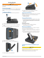 5
5
-
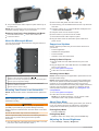 6
6
-
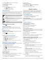 7
7
-
 8
8
-
 9
9
-
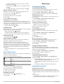 10
10
-
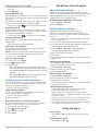 11
11
-
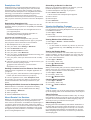 12
12
-
 13
13
-
 14
14
-
 15
15
-
 16
16
-
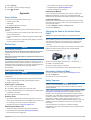 17
17
-
 18
18
-
 19
19
-
 20
20
-
 21
21
-
 22
22


Garmin BMW Motorrad Navigator V Owner's manual
- Category
- Car navigation systems
- Type
- Owner's manual
Ask a question and I''ll find the answer in the document
Finding information in a document is now easier with AI
Related papers
-
BMW Motorrad Navigator Street Owner's manual
-
Garmin Fleet fleet660 Owner's manual
-
Garmin Nüvi 56 Owner's manual
-
 Garmin Zumo Zumo 590 User manual
-
Garmin Zumo ZUMO 340LM Owner's manual
-
Garmin zūmo® 590LM Owner's manual
-
Garmin Camper 660LMT-D Owner's manual
-
Garmin zūmo® 395LM Owner's manual
-
 Garmin Zumo Zumo 395 Owner's manual
-
Garmin Zumo 010-01603-00 User manual


Other documents
-
BMW Navigation Portable Pro User manual
-
-
Trident AMS-WINDSHIELD Datasheet
-
N-Com B602 and Garmin BMW Navigator VI Operating instructions
-
N-Com B902 and Garmin BMW Navigator VI Operating instructions
-
CTA Digital PAD-SST Datasheet
-
Mio H610 User manual
-
-
 IKU Curvy C40i 3G User manual
-
CTA Digital PAD-SMT Datasheet
